DOC NOSS-Victorio Peak OR The Caballo Mountains

treasminder2

Banned
Oct 9, 2011
799
663
here ya go viewers
I snatched this image off the web of a Camera exactly like my Dad's that I used to take
the photo's of the content of the Treasure Cavern where the Oryx was crushed by
the Dead Fall Trap
this is the type of camera use for that Photo I took

NOT Rob Kryder or KX member , both of which never saw that Oryx insitu

camera

View attachment 1205249

That is the exact type of Camera that i took the photo's with
Dad's 1950's Yashika 35mm

I as well used a Kodak 110 for some of the shots
 

markmar

Silver Member
Oct 17, 2012
4,120
6,263
Primary Interest:
All Treasure Hunting
treasminder 2

When you say " Treasure cavern " what you mean ? Have you or your dad found there a treasure ?
 

gollum

Gold Member
Jan 2, 2006
6,729
7,598
Arizona Vagrant
Detector(s) used
Minelab SD2200D (Modded)/ Whites GMT 24k / Fisher FX-3 / Fisher Gold Bug II / Fisher Gemini / Schiebel MIMID / Falcon MD-20
Primary Interest:
All Treasure Hunting
Hey Rog,

Funny thing, Casitas de Adobe is no longer open. Both phone numbers I found for them have been disconnected. Maybe the government murdered them???

Mike
 

treasminder2

Banned
Oct 9, 2011
799
663
I was afraid of that
if it's closed , then Gabe passed away as I suspected
he was Obese with a lot of health problems

I am going to guess they went in about 1900 to 19 teens sometime

Beasley's escorted them through the Canyon

it was Gabes G-G Father with a few other town folks

an Old Old Man was leading them to the Tomb , he knew of it from his elders that
were in a party of people who lived in the mountains . The old man was probably a descendent
of the Aguires <----<< however you spell that name .

I'll find out from Sam if Gabe is gone

Gabe tripped out when Sam Introduced me and said : Rog' here is descended from the Man your G-Grampa
took to rebury in Messilia
he said : so you know the Knights Templar were here before Columbus sailed

Gabe said no one in town believed the crew that His G-G Father was with .
 

gollum

Gold Member
Jan 2, 2006
6,729
7,598
Arizona Vagrant
Detector(s) used
Minelab SD2200D (Modded)/ Whites GMT 24k / Fisher FX-3 / Fisher Gold Bug II / Fisher Gemini / Schiebel MIMID / Falcon MD-20
Primary Interest:
All Treasure Hunting
I was afraid of that
if it's closed , then Gabe passed away as I suspected
he was Obese with a lot of health problems

I am going to guess they went in about 1900 to 19 teens sometime

Beasley's escorted them through the Canyon

it was Gabes G-G Father with a few other town folks

an Old Old Man was leading them to the Tomb , he knew of it from his elders that
were in a party of people who lived in the mountains . The old man was probably a descendent
of the Aguires <----<< however you spell that name .

I'll find out from Sam if Gabe is gone

Gabe tripped out when Sam Introduced me and said : Rog' here is descended from the Man your G-Grampa
took to rebury in Messilia
he said : so you know the Knights Templar were here before Columbus sailed

Gabe said no one in town believed the crew that His G-G Father was with .

Was his name Gabe or Gil. The only contact information I could find for the business was named Gil Hernandez.

Mike
 

treasminder2

Banned
Oct 9, 2011
799
663
THANKS , yes , Gil
Memory is crap anymore

I think Sylvester or something like that is a brother or cousin .

about time line on the recovery

I know Great great Grand Dad
had to be in the area from over in Quitman Georgia at the time
and Staying at the Sinclair ranch in Bar Canyon .

so that was early in 1900's
 

Treasure_Hunter

Administrator
Staff member
Jul 27, 2006
48,542
55,118
Florida
Detector(s) used
Minelab_Equinox_ 800 Minelab_CTX-3030 Minelab_Excal_1000 Minelab_Sovereign_GT Minelab_Safari Minelab_ETrac Whites_Beach_Hunter_ID Fisher_1235_X
Primary Interest:
All Treasure Hunting
Treasminder keep politics out of thread....
 

Jan 16, 2011
5,010
5,037
By, By Have fun.
Detector(s) used
Time to move on. Good luck everyone .
Primary Interest:
All Treasure Hunting
Thanks treasminder2 for that Rascione name,Its in the area that i believe is a Templar site. It has helped me to see what some of there signs are.Hopefully i can get inside one,and back out. Those guys got around,thats for sure. If those signs that i have found are Templars, I cant say for sure yet., but iam sure treasminder2 would know. Iam sadden again on his loss of being able to post.
 

gollum

Gold Member
Jan 2, 2006
6,729
7,598
Arizona Vagrant
Detector(s) used
Minelab SD2200D (Modded)/ Whites GMT 24k / Fisher FX-3 / Fisher Gold Bug II / Fisher Gemini / Schiebel MIMID / Falcon MD-20
Primary Interest:
All Treasure Hunting
I missed it dangit. Did Rog get a timeout or banned again?

Well.......................... see ya when ya get reinstated!

Mike
 

whiskeyrat

Hero Member
May 7, 2012
539
1,246
mid Michigan
Primary Interest:
Prospecting
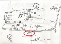
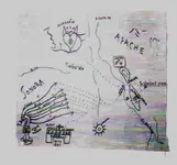
this symbol appears twice on the map said to be "willies map".
anybody care to enlighten me what it might mean?

to me it might mean a mission site. but at the top of the map the symbol is inside the setting sun (above the ground) so that a mission location does not make sense.

symbol on willie map.jpg

thanks
wr
 

markmar

Silver Member
Oct 17, 2012
4,120
6,263
Primary Interest:
All Treasure Hunting
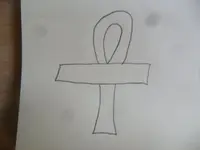
The Ankh Cross

also known as the Ansata Cross (crux ansata - 'Cross with handles') and the Egyptian Cross

ankh.png

Ankh Cross

ankh02.png

Ankh Cross
Looking like a person standing with outstretched arms, the Ankh Crossis a looped Tau Cross and an old Egyptian hieroglyph meaning 'life'. It sometimes goes by the exotic name Key of the Nile.
 

mdog

Bronze Member
Mar 22, 2011
2,363
4,416
.........another possible reason for bringing all that gold/silver that far North would be that maybe they were hooking up with French Jesuits to take to the NorthEast, then across the Atlantic to Rome.

Just a thought.

Mike

I was looking at the trail going toward the NE and google earth shows Starvation Peak at about that spot SE of Santa Fe. The second picture in this link shows the peak and it seems similar to the drawing on NP's map.

Starvation Peak - New Mexico, United States ? peakery

If the map's drawing is indicating Starvation Peak, that would put the end of that trail right by the network of trails known as the Santa Fe Trail. I know from my research that the Santa Fe Trail links up with important trails in the upper Midwest that continue on to the Detroit, Michigan area and from there it's a water trip to Quebec.

I've been studying the possibility of a smuggling route from the SW to New France for several years and I don't think the idea is too far fetched.
 

whiskeyrat

Hero Member
May 7, 2012
539
1,246
mid Michigan
Primary Interest:
Prospecting
The Ankh Cross

also known as the Ansata Cross (crux ansata - 'Cross with handles') and the Egyptian Cross

ankh.png

Ankh Cross

ankh02.png

Ankh Cross
Looking like a person standing with outstretched arms, the Ankh Crossis a looped Tau Cross and an old Egyptian hieroglyph meaning 'life'. It sometimes goes by the exotic name Key of the Nile.

Thanks, good info but dang that does not help with solving the map at all.
Need something on the map that is a recognizable land mark to give it a location or at least a starting point. eternal life does not lend itself to anchoring a map in the physical world very well.
wr
 

gollum

Gold Member
Jan 2, 2006
6,729
7,598
Arizona Vagrant
Detector(s) used
Minelab SD2200D (Modded)/ Whites GMT 24k / Fisher FX-3 / Fisher Gold Bug II / Fisher Gemini / Schiebel MIMID / Falcon MD-20
Primary Interest:
All Treasure Hunting
this symbol appears twice on the map said to be "willies map".
anybody care to enlighten me what it might mean?

to me it might mean a mission site. but at the top of the map the symbol is inside the setting sun (above the ground) so that a mission location does not make sense.

View attachment 1206004

thanks
wr

WR,

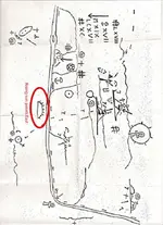
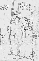
I will give you a bit of help here; On maps, West is shown as a setting sun. A setting sun is ALWAYS shown as a half circle with a line underneath and NO RAYS FROM THE HALF CIRCLE. East is shown as a half circle with a line underneath and MULTIPLE RAYS EMANATING FROM THE HALF CIRCLE. Usually, the number of rays means something (typically days of travel). A perfect example is on Willie's Map:

If you orient it so you can read it, it is not oriented North-South. If you look at the half circle with seven rays, you will see that it is aiming to the (actual) East. Now, if you hold the map so that the top long side is on the right side, you will see that the map is oriented correctly North-South. The Rio Grand is N-S, and all the mountain ranges are N-S like they should be. Now you just need to figure the math and the symbols.

williemap2.jpg williemaporiented.jpg

Don't say I never gave you anything! HAHAHA

Mike
 

Last edited:

gollum

Gold Member
Jan 2, 2006
6,729
7,598
Arizona Vagrant
Detector(s) used
Minelab SD2200D (Modded)/ Whites GMT 24k / Fisher FX-3 / Fisher Gold Bug II / Fisher Gemini / Schiebel MIMID / Falcon MD-20
Primary Interest:
All Treasure Hunting
Mike mi bosum buddy. you 'rh' map is oriented in reverse. It shows the rising sun in the west etc..
merely rotate the first map 90 degrees counterclockwise. or the second 180 degrees also counterlockwise.

Don Jose,

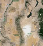
Sorry mi amigo, but you are mistaken here. There are landmarks on the map that when oriented as I have it on the "RH" are correct. The most predominant of which is the Malpais and small volcanic smokers (go to Google Maps and search for "Malpais-Valley of Fires, Carrizozo, NM) There is only one significant lava flow in the area, and that is it:

MAP.jpg WilliesMapPicture.jpeg

The Google Maps Screenshot is accurate against Willie's Map. The flow of the Rio Grande, the North-South Fra Cristobals and Caballos, The Organs, The Malpais, and the Ruidoso Mts (where there is another treasure cave on the Mescalero Apache Reservation). Even down to the little island in the Rio Grande near Paloma Pass:

RioGrandeIsland.jpeg

Mike
 

Last edited:

gollum

Gold Member
Jan 2, 2006
6,729
7,598
Arizona Vagrant
Detector(s) used
Minelab SD2200D (Modded)/ Whites GMT 24k / Fisher FX-3 / Fisher Gold Bug II / Fisher Gemini / Schiebel MIMID / Falcon MD-20
Primary Interest:
All Treasure Hunting
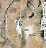
Here is Willie's Map with sections overlaid onto a Google Maps Screenshot:

WilliesMapPicture1.jpg

I assume its the Rio Grande because it shows an island in the middle of it. An island which is actually on the map in the same location. I double dare you to find me volcanic lava flows like the Malpais anywhere else that the map shows.

Mike
 

Last edited:

Top Member Reactions

Users who are viewing this thread

Latest Discussions

Top