Highmountain
Hero Member
During the early 1990s I spent a lot of time for a couple of years examining the area mentioned. It's an area rich in unwritten history and hasn't had much interest or visitation by folk of recent times because of difficult accessibility.
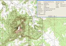
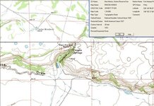
Fort Atarque: This is located on NM State land and there's a two-track that was once a country road going not-too-far from it. My guess is the worse two-track that leads from the once-county-road to the ruin is also legal even though across private ranch land by virtue of a peremptoral easement, whatever the Atarque Ranch owner policy might be these days. It resembles a fort, but is actually an ancient NA ruin along the Zuni Salt Trail.
The ruin sits atop the west side of a lava cliff face with springs about 100-150 feet below. The cliff face has hundreds of petroglyphs of all sorts, though difficult to reach. The cliff-face has peeled off in places to remove the ancient path from the ruin down to the water, but it's easy to follow what's left of the path by the trails of potsherds, and possible to climb around if you want to visit the springs below. Interesting and fascinating site, though not one where artifact collecting is advised. The springs below are on private land belonging to Atarque Ranch.
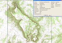
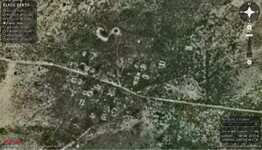
Atarque ghost town is one of the most undisturbed I've ever visited. If it's still accessible at all it will require some sweet-talking with the ranch manager because it's on private land. Last I heard the ranch is owned by an oil-magnate in Roswell who has ranches all over New Mexico. That puts the ranch manager into a position of having to officially walk the party line as to what's allowed and what isn't, but if it's the same one as managed it in the 90s he'd occasionally make exceptions to the rules.
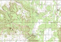
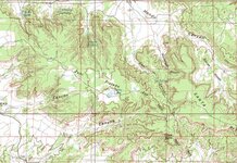
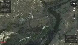
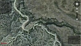
Jaralosa Canyon is mostly private but access can be achieved, or could be last I was there, though it requires study of the maps and some innovative approaches. But the north face of the canyon has dozens of fascinating ruin sites where there's water, and the biggest petroglyph complex I've ever seen about mid-way between Fort Atarque and Alamo Canyon on the north face of Santa Rita Mesa.
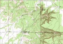
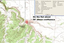
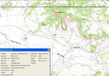
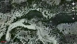
Alamo Canyon is possible to access legally by going in from the Santa Rita Mesa side, hopping a fence from public road to public land, and hiking along the watercourse downward to the north. But it's worth it. There's what appears to be a hideout ruin above the cliffs between the confluence of the two branches of Alamo Canyon watercourse.
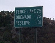
Santa Rita Mesa access is difficult but the top of the mesa is partly private, part public. Last I heard it was ranched by one of the Cox brothers out of Quemado who'd built a home in Rincon Canyon [which might have changed a number of things about how a person might approach access questions for the entire area]. If the store in Fence Lake is still operating the lady running the place has always been hungry for conversation and might fill you in on the current situation concerning ownership and access.
If anyone's interested in poking around the area I can provide you with a lot of detail of where things are located and how things were in the 90s, but I haven't been there in a decade.
Jack
Fort Atarque: This is located on NM State land and there's a two-track that was once a country road going not-too-far from it. My guess is the worse two-track that leads from the once-county-road to the ruin is also legal even though across private ranch land by virtue of a peremptoral easement, whatever the Atarque Ranch owner policy might be these days. It resembles a fort, but is actually an ancient NA ruin along the Zuni Salt Trail.
The ruin sits atop the west side of a lava cliff face with springs about 100-150 feet below. The cliff face has hundreds of petroglyphs of all sorts, though difficult to reach. The cliff-face has peeled off in places to remove the ancient path from the ruin down to the water, but it's easy to follow what's left of the path by the trails of potsherds, and possible to climb around if you want to visit the springs below. Interesting and fascinating site, though not one where artifact collecting is advised. The springs below are on private land belonging to Atarque Ranch.
Atarque ghost town is one of the most undisturbed I've ever visited. If it's still accessible at all it will require some sweet-talking with the ranch manager because it's on private land. Last I heard the ranch is owned by an oil-magnate in Roswell who has ranches all over New Mexico. That puts the ranch manager into a position of having to officially walk the party line as to what's allowed and what isn't, but if it's the same one as managed it in the 90s he'd occasionally make exceptions to the rules.
Jaralosa Canyon is mostly private but access can be achieved, or could be last I was there, though it requires study of the maps and some innovative approaches. But the north face of the canyon has dozens of fascinating ruin sites where there's water, and the biggest petroglyph complex I've ever seen about mid-way between Fort Atarque and Alamo Canyon on the north face of Santa Rita Mesa.
Alamo Canyon is possible to access legally by going in from the Santa Rita Mesa side, hopping a fence from public road to public land, and hiking along the watercourse downward to the north. But it's worth it. There's what appears to be a hideout ruin above the cliffs between the confluence of the two branches of Alamo Canyon watercourse.
Santa Rita Mesa access is difficult but the top of the mesa is partly private, part public. Last I heard it was ranched by one of the Cox brothers out of Quemado who'd built a home in Rincon Canyon [which might have changed a number of things about how a person might approach access questions for the entire area]. If the store in Fence Lake is still operating the lady running the place has always been hungry for conversation and might fill you in on the current situation concerning ownership and access.
If anyone's interested in poking around the area I can provide you with a lot of detail of where things are located and how things were in the 90s, but I haven't been there in a decade.
Jack
Amazon Forum Fav 👍


Attachments
-
 Santa Rita Mesa - hideout.jpg84.5 KB · Views: 1,721
 -
 Fort Atarque Ruin FE.jpg41.6 KB · Views: 1,415
 -
 Fort Atarque Ruin 1.jpg64.5 KB · Views: 2,643
 -
 Atarque Ghost Town Ruin FE.jpg135.3 KB · Views: 2,369
 -
 Atarque ghost town 34 44 5.51N 108 42 7.46W2.jpg78.9 KB · Views: 1,579
 -
 Atarque Santa Rita Mesa hideout ruin FE 2.jpg53.3 KB · Views: 1,431
 -
 Atarque Santa Rita Mesa hideout ruin FE.jpg89.2 KB · Views: 1,688
 -
 Enjoy the Fence lake for 8 bits Reserve aint worth a buck 31.jpg27.1 KB · Views: 1,330