treasure1822
Hero Member
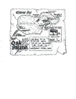
Okay, the problem lies with me. I am not being clear enough. This map is from Harold T. Wilkins book, "Captain Kidd and his skeleton Island". It was drawn by Harold T. Wilkins in the early 1900's taken from a map that he said he had seen in the British museum. The rough Shape of the island, the text describing distance and direction, and the reference to North, South, East and West are what I believe to be a part of the original map. Everything else was probably added by Wilkins or the publisher to enhance the book. Gilbert Hedden had the island surveyed and it is known as the "Roper" survey. When they surveyed they found that the "Money Pit" was 14 rods North of the "Stone Triangle". They also found the 2 white granite stones with the 1/4 inch holes on the top of them and they were 25 rods apart. They found that if marked 7 rods west of the Eastern stone the "Stone triangle" was roughly 30 rods southwest of that point. The only thing that Hedden couldn't understand was the "7 by 8 by 4"-....Jean Lafitte had made a statement that A parrot will repeat what it hears, a monkey will imitate the movements of man, you can lure furred animals in to traps with shiny objects and man can be lead down bad or false paths. He also believed in one particular piece of the Bible, PROVERBS-14:15 and it reads something like "A simple man believes every word, the intelligent man gives thought to his steps". Think about it; remove everything except the shape of the Island, and the text (18 W by 7 E on rock, 30SW, 14N, Tree, 7 by 8 by 4 and the reference to North South East and West. Now orient the map so North is "UP" (and I know that it is not a "true" representation of true North to the position of the island) If you notice the words now will be "upside down". If I told you to read the directions again I believe everyone would say (18 W by 7 E on rock, 30SW, 14N, Tree, 7 by 8 by 4) because everyone has already read it. The problem with that is to be correct you have to start at the top and work your way down reading from left to right. So do me a favor, I want everyone to rotate each word 180 degrees just like taking a pin and putting it in the center of each word then rotate it so you can read it. What you have just done is change directions or go backwards. Now if you read it, it says to (7 by 8 by 4, Tree, 14N, 30SW, 18W by 7E on Rock) Now that doesn't make sense to the island but we are forgetting one important thing and that is the "Key" to this. "CHANGE DIRECTION" (7 BY 8 BY 4, TREE, 14 SOUTH 30 NORTHEAST, 18 EAST BY 7 WEST ON ROCK) There was a Stone found by Dan Blankenship and it had the letter "G" on it and it was found as close as I can figure was "Near the Cave-In Pit". That's where the map takes us and as I have said since before this forum, "The Templar's and the Masons are the same", the Masons are just a refined order of the templar's. So, where is the Letter "G"' found to a Mason, well besides in the center of the square and compass, On the Eastern Wall or "ABOVE THE ENTRANCES TO ANY MASONIC STRUCTURE". So, if any of you are wondering about the 7 by 8 by 4, stop and think out if you had to give someone directions. What are two things that have to definitely be given? How about a “START” and a “FINISH” point. The finish point is given on the map but the start is no so easy. Granted the map says 7 by 8 by 4, and Gilbert Hedden was thinking dimensional like triangle but is it possible to write it another way to sat it? Yes, the answer is 784. The 7 is by the 8 which is by the 4. Now this is the only ”Error” that I believe Wilkins made when he copied the map. I believe that Wilkins misread the number 7 and it should have been 1. The only reason I say that is because of the “Boat Stone” found in Westford Massachusetts found 30+ years ago. It has a “BOAT” and a “ARROW” which I would say it is pointing down and the number 184. And believe me that people who have actually view this up close said “184”. I am taking their word because hey, they were there not me. Break down the meaning of each thing on the stone. “BOAT”, which at looking at it is not a small dory or small fishing boat. It is a representation of a larger boat or sea going vessel. Where do you find these boats? On the sea, or in this case along the sea coast. “ARROW” which is what I would presume to be self-explanatory, it shows direction. But in this case since we do not know how the stone was oriented I cannot prove which way it pointed. The best that I can do is refer back to my maps directions and assume that the “ARROW” was pointing south and I am to reverse directions go backwards which means I head north. “184”, has to be distance, but they didn’t use miles or kilometers, they measured distance in what was known as a “LEAGUE” which is a unit of measure that is based on how far a person could walk in an hour and it ranges from 2.4 to 4.6 miles per hour. Now think about this, “SEA COAST” + “NORTH” + “184 LEAGUES” or 441.6 to 846.4 miles away. Does the location of Oak Island fall within those parameters? Oh yeah. But wait, with such a large difference between 441 to 846 mile, how do I know that it the right area? Remember how I have said that it was “Sinclair” and his men. That less than two miles from where they found the “Boat Stone” lies a carving of what they call the “Westford Knight”, supposedly Sir James Gunn a member of Sinclair’s party. They say that it has properties of “Viking” carving but the sword on the carving was 1400’s. Anyways, follow the shoreline on the southeastern side of Nova Scotia on the southern shores of Mahone Bay on what is now known as 2[SUP]nd[/SUP] peninsula. There is the “The Norumbega Vinland Stone” a memorial stone to immortalize the achievements of a person or people in their lifetime. The only problem, it’s not complete and it doesn’t make sense. If you are viewing the writing on the stone, you are also looking at Mahone Bay. Find the island that matches the maps. What do you do when you land on the island? You do exactly what McGinnis and his two friends did by accident, “FIND THE TREE” the starting point on the island. Please do not tell me that this was too complicated to figure out because more work to design the money pit and it’s nothing more than a false path. I have put a lot of time in this…..so where is the treasure. From the first marker in Westford Massachusetts follow the coast north walking for about 23 days. When you find the second marker look for the island that matches the map. Once on the island find the tree that sticks out. From there move 14 rods south to the stone triangle, then northeast so the 30 rod straight line goes from the stone triangle and thru the point that lies 7 rods west from the east stone and 18 rods east of the west stone. There you will find a stone with a “G” marking the entrance of the Vault. I theorize that this map was created not for just anyone, maybe it was meant for Sinclair’s family but they couldn’t put the pieces together and later the map and charts were donated to the British museum.


