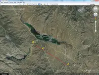
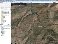
Is my mine the LDM?

Why i searched in the north-east range in the supersititon mountains…
Bicknell wrote: 56 miles from Phoenix and some 18 miles south-east of goldfield.
Why he wrote 56 miles? In his second article he wrote more than 50 miles – that makes sense for me. How he came to 56 not 55? I think it is a true first hand clue. (56 miles is the yellow circle)
He wrote 18 miles east of goldfield. Goldfield? He wrote the article in 1894. Goldfield area was discovered 1892. Waltz died 1891. I think this area was named with the discovery of the gold veins. So in 1891 it didn’t have any name. in some stories I read that the Dutchman was often seen in the pub of tortilla flat. Same question – why he wrote 18 miles not 20 or 15? The Dutchman couldn’t give the clue from goldfield, but where does the 18 miles come from? IMO the Dutchman gave the hint 18 miles to mrs. thomas but from his pub and not from goldfield. (18 miles is the purple circle)
In the holmes manuscript he said that he bought new equipment in Superior (picked post). After 15 miles he met the Indians. (15 miles is the green circle) on second day he didn’t go far. (4 miles is the red circle). IMO the mine can’t be in this area, because he discovered it on his 3rd day. What would I do after 2 days alone in the desert? I had no water… what is the fastest way to get out of the desert? I live in phoenix. I know north of me is the salt river. I would go straight north and I would look for a bushy canyon. I would search for some timber and would swim with the flow of the river directly to my home or tortilla flat.
If the 56 miles clue is right then it cant be in the south-east direction, because it contradicts with the holmes manuscript.
I don’t say that this clues are proven, but so I was able to narrow the search. In this area I searched for the two major clues the 3 hills and north-south tending canyon. Then I fit the locator map and some other clues. I flew to Arizona. I went out and found at this spot the marked cactus, the big quartz vein, the quartz hanging wall and the sealed mine. How big was the possibility that I found anything at?
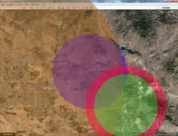
distance.jpg
 

Last edited:
markmar! man whats wrong? it isnt a try... its my research result. thats why i create a new thread. everyone that dont like it, read it, laugh and have fun but dont offend me only cause i had my own thinkwise. go out make your own thread, have fun, enjoy the hunting. if any citizen wants to help me plz contact me.

My apologies if i have offended you . Was not my intent .
Good luck with your thread and theory .
 

My apologies if i have offended you . Was not my intent .
Good luck with your thread and theory .

your opinion is always welcome. my statement of goldfield is so wrong ;) waltz worked a mine in the goldfields. only the town was founded in 1892. i think every distance indication make sense with fix points. phoenix, tortilla flat and superior. it also make no sense to count your foot steps and tell it anybody. they will never know which trail you used and have not your foot step length.
 

BlackLine

Also , Bicknell never found the LDM .
 

BlackLine

Also , Bicknell never found the LDM .

he had not the technical equipment. thermal camera, maps (google earth), gps, metal detector. i think today should it be easier. :blackbeard:
 

he had not the technical equipment. thermal camera, maps (google earth), gps, metal detector. i think today should it be easier. :blackbeard:

Today, if you have the access, infrared spectroscopy from satellite will give you not only the old river channel's but old unused trails no longer visible on GE or by aerial photo. You could literally turn back time and see where Jacobs and the old military trail's were.
Human trails look just like animal trails when use very little or not at all. It would take a team of people quite some time to go over every square inch of that whole range. As for trail markers in the field, Secret Walkers Royal Trails are what you follow. No other maps matter. If you know how to follow that trail you'll get to the mountain of the Gold Mine. There're clues in the entrances from south and east carved into the cliffs. For Walkers trails, which are or can be high trails, they're marked very far apart so a compass and GPS with GE on a computer or tablet. A Hot Spot Satellite phone would help.

I think all these maps over the years are just confusing which is what they're intended too be. None of the Thunters around there want anyone to find it.

You'll need to be an expert on the abstracts they used. The Free Mason's abstracts that is. None of this was done with out Masonry. It's a very complicated and timed system. In other words it takes time to decode the end game once you find it. If you can ever find it. It'll have to be done in the mountains on foot. Just like you did when you were here BlackLine.
 

Last edited:
i love hikearizona.com
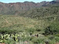
found a beautiful photograph of my mine site. think now you can see waltz cave.

View attachment 1348830

Peak 3940 - Roosevelt Dam Quad Photo #18 ? CannondaleKid ? 2014-09-14 ? HikeArizona.COM

is anybody a good drone pilot and have nothing to do? plz take a vid from the cave.

How do you know the cave clue or the face clue are real? From what's been going on lately I would say none of the clues are real and only a small fraction if any are known publicly.
With that being the case the only thing that matters is the ore. If the Ore assays out rich beyond belief I would dare say you've just found it. Other than that its sort of like a game
in which there're no winners only players.
 

how runs the gold vein? the nearest gold claims i found are on the satelite pic. i connected them only because i want to see how far it is away from my site.

gold-claims.jpg
 

How do you know the cave clue or the face clue are real? From what's been going on lately I would say none of the clues are real and only a small fraction if any are known publicly.
With that being the case the only thing that matters is the ore. If the Ore assays out rich beyond belief I would dare say you've just found it. Other than that its sort of like a game
in which there're no winners only players.

i can only offer my indicators. i am sure anyone anytime will check it and assay the ore. i have only fun to give you my results. i have here nobody that is intresting in the legend and it is a good feeling to lose the load.
i dont know if any clue is right or not, but if I do not contemplate it, i will not find anything. i would go out and hike and hike and hike without any trace.
 

Years back, I read a story in the Florence, Arizona Ladies library. I was waiting for my Dad who was playing bridge there. It had a story about Waltz and Wiesner sinking a shaft on a low grade outcrop. Supplies were getting low so Waltz went to Queen Creek trading post for supplies. That told me that he came out of the Supes from the Peralta Trail head. Closer to Queen Creek as First Water would be closer to Phoenix. When he got almost back to the camp, he stopped and went up a ridge so he could look down at the camp. There he saw Wiesner staked out with burning slivers stuck in him. He slid down the slope back away from the camp and took off for Phoenix, leaving the horses. He staggered into Phoenix about 2 weeks later almost dead from exhaustion. He would not go back out until about 3 months had passed as he was scared of the Indians. When he went back he put Wiesner's remains into the shaft and covered it with logs for a grave.
Now he talke about his "mine" as being covered with logs. (Wiesner's grave) When did he start talking about having a "rich mine"? After Waltzr turned in $18,000 in gold in Tucson? That is what I believe.
 

i can only offer my indicators. i am sure anyone anytime will check it and assay the ore. i have only fun to give you my results. i have here nobody that is intresting in the legend and it is a good feeling to lose the load.
i dont know if any clue is right or not, but if I do not contemplate it, i will not find anything. i would go out and hike and hike and hike without any trace.

A lot of us like the legend. Although Waltz himself was a confessed murderer and known liar he had some proof, not much. The legend itself has been hashed over so many times on here and other sites it becomes monotonous. You're right though contemplation is a good motivator. The area you're showing is near Roosevelt Lake. I never knew there was a gold vein there. Indicators are all over those ranges. Mining has been part of the region for centuries. Your research is very good and your in the field videos showing the places of your ventures. Keep up the good work I like it.
 

A lot of us like the legend. Although Waltz himself was a confessed murderer and known liar he had some proof, not much. The legend itself has been hashed over so many times on here and other sites it becomes monotonous. You're right though contemplation is a good motivator. The area you're showing is near Roosevelt Lake. I never knew there was a gold vein there. Indicators are all over those ranges. Mining has been part of the region for centuries. Your research is very good and your in the field videos showing the places of your ventures. Keep up the good work I like it.

oh you cant find it with the map search from the mindat.org or minedata.azgs.az.gov
Christmas and Good Luck Lodes, M.S. 4587 | Arizona Geological Survey Mining Data
Christmas Gift MS 4587 claim (Good Luck MS 4587 claim), Roosevelt, Gila Co., Arizona, USA

i checked all gold claims from pinal, maricopa and gila until i found it. nobody would search outside of the wilderness, but as i began my research i didnt know the borders of the wilderness :) so for me it had no weight.
as i connect the mine entrance and the vein and draw the line further then i land at the site of my burbridge/peralta map interpretation. then i take the minas del oro map which match with camp (bottom) from the burbridge map. on the minas del oro map right bottom is the "placeres del oro" in this creek i would check the soaps for placer gold. hope you can follow me :D

placer-gold.jpg

the owner of the mining claim William H. Passey was in 1948-1949 president of Mesa Rotary Club. he named his claim Christmas and good luck lodes. intresting that he named his claim like the feast of charity ;)
 

Last edited:
oh you cant find it with the map search from the mindat.org or minedata.azgs.az.gov
Christmas and Good Luck Lodes, M.S. 4587 | Arizona Geological Survey Mining Data
Christmas Gift MS 4587 claim (Good Luck MS 4587 claim), Roosevelt, Gila Co., Arizona, USA

i checked all gold claims from pinal, maricopa and gila until i found it. nobody would search outside of the wilderness, but as i began my research i didnt know the borders of the wilderness :) so for me it had no weight.
as i connect the mine entrance and the vein and draw the line further then i land at the site of my burbridge/peralta map interpretation. then i take the minas del oro map which match with camp (bottom) from the burbridge map. on the minas del oro map right bottom is the "placeres del oro" in this creek i would check the soaps for placer gold. hope you can follow me :D

View attachment 1349066

the owner of the mining claim William H. Passey was in 1948-1949 president of Mesa Rotary Club. he named his claim Christmas and good luck lodes. intresting that he named his claim like the feast of charity ;)

I looked at that area. It seems it's been designated as the "Fictitious Arizona Trail" so no mining of any kind can be done.

It also looks like extensive hydraulic mining was done there you can tell by the dirt over the bed rock facing being stripped off. Just like Greaterville down here south of Tucson. If it's not closed off for vehicle travel, you could get there fairly easy with a 4x4. Sampling around with a dry washer you may find some flakes. Close to Apache Lake and Roosevelt Lake Marina. Not to hard a place. You could drive to it. Just like Frank likes.

The Bat Cave on the other hand would be much easier by pontoon boat which I have ready for a trip. Just waiting for the procedure on my left knee to be finished. I hiked last year all year with a swollen left knee. Sometimes I didn't know if I would make it back because of this. Now, I can't even climb stairs mush less hike or pan gold.

The same thing happened to my right knee only I suffered with that for almost 40 years. I'm not going through that again on my left knee.

I haven't got that much time left!!

Nice area!

what a f...! no mining allowed!? how far from the trail? :BangHead:
isnt it a treasure from national importance? nice endpoint for all arizona trail hikers.
 

Hi Bill, getting a lil wobbly my self these days, so no more hi sierras for me, that includes Tayopa --- sniff.

Quitcha belly aching, how are you going to be at my 150 th birthday party ' NOT ENOUGH TIME" humph.
 

Last edited:
A pontoon boat? Not unless you want to swim in.

It ain't so big Frank.

00I0I_ivRJ1iFr6TM_1200x900.jpg


"I for the life of me have no pictures of me boat and it's in storage but it's identical to this Pontoon".

I have a rubber dingy thingy (Raft) for the landing. I just park it out with quad anchors and off I go!

Swimming? Not a bad idea if it's hot! Just went a few weeks back down in Patagonia Lake. Had a lot of slime in it. It rained a little and cleared the lake of all other boats so we swam and swam all over that damn place. Anchored that Party Cruiser and dove off the roof all day. Searching for a port has never been a problem. It'll go in less than two foot of water. Perfect for diving or dredging. Sort of a "Redneck Deck Party". The lake was so full the islands in the middle were almost submerged. I've camped at Canyon Lake many years ago. Saguaro Lake, Apache Lake, too. I've had many boats in Roosevelt. My favorite is the big pontoons. Big large v bottoms & cabin cruiser's are great also.

My Toon is not Pristine by any means I had to fix it once I bought it. But the fun factor is always there and if you need a good place to sleep for the night it has heat and cool with beds.
 

Top Member Reactions

Users who are viewing this thread

Back
Top