Aric
Jr. Member
- Feb 20, 2015
- 35
- 33
- Detector(s) used
- Currently using the Gepard GPR.
- Primary Interest:
- Prospecting
At that time I believe Jacob Waltz always took the trail in coming from the north. I think this was a advantage that Jacob Waltz knew he had cover on both sides of him. When Jacob Waltz left the trail to take a short cut to the mine his heading was 137 degrees just like it is today. This is about one mile from the mine. After leaving the trail it would take Jacob Waltz about one hour to get to the mine in this box canyon. I also believe this is the reason where I have read where Jacob Waltz was either coming back from the mine from the north or leaving town and heading north to the mine. If Jacob Waltz thought he was being followed he could circle around and wait and still return to the trail to the mine. I think Jacob Waltz always thought you can never be to careful.
After Jacob Waltz would leave the trail it would take him about 30 minutes before he would have to make a right turn and headed south at this point he could look down and see if any person or persons were lurking near his mine. This point is about 300 feet higher than the mine entrance. In my opinion this is the only trail that Jacob Waltz could take or would take to his mine. There is no way that Jacob Waltz came in from the east or west because he would be wide open for any person to see him and I think Jacob Waltz knew this very well. If Jacob Waltz came in from the south he would have been ambushed very easily. The only safest way into the mine was from the north.
Many years ago in my home country which is southern Germany not far from the border of France there was a rumor and maybe still to this day that Jacob Waltz had built a stone house in a canyon. They say Jacob Waltz had built this stone house over the portal or entrance to his mine. The reason I would bring this up is because earlier this year I came across a small foundation measuring 22 feet x 35 feet which equals to a total of 770 square feet. The foundation faced the northwest. I don't know who built this small house. I thought it was weird to have built a house in this box canyon with only one way out. In those days I would think that would be suicide unless you had a very good reason to build a house right there. The stones laying around this foundation don't match the surrounding stones. These stones are a lot smaller in size. The only thoughts I have is they might have come from digging/tunneling. What better way to remove and hide tunneling rock by building a stone house right over the mine. By the way there is a rather large stone heart that measures almost 10 feet across and almost 10 feet long. This stone heart lays behind the old foundation, the heart is cracked on the left as you look at it. You can only see it is a heart by looking at it from one angle and of course the heart faces west. This heart would have taken several men to move into this position. I doubt if it has ever been moved since. I would think the stone house would have covered up the stone heart if the stone house had walls 6 feet or higher. I have not found any logs laying around. If you climb up about 80 feet above the old foundation you can see Weavers Needle to the south south east. To the west is a small cave about 200 feet away. What really makes me wonder about this place is this. If you walk across to the west climb up on the cliff across from the foundation and look down at the area around the foundation area you can clearly see that vegetation doesn't grow very well.
Where you have read or may have not read this quote by Jacob Waltz. " If you pass three red hills you have gone to far ". This quote is true. It takes about 30 minutes to walk pass these three hills on a down ward slope. The red hills will be on you're right as you walk pass them. Once you have passed the three hills you should be 15 minutes or less from the gold mine. It's easier going walking in on the right side than if is on the left. This is very rough ground. Once you have reached the front of the gold mine when you're standing there you will think you're standing at the bottom of a funnel when you look up and all round. And you will understand why Jacob Waltz only went to the gold mine when he thought the Apache were not in the area. During the Fall & Winter season you will not have sunshine on the gold mine entrance after 4:30pm because of the hill to the west.
What I know to be the truth to me is this. I know the Peralta stone maps are a copy from a original map that the Peralta family once owned and had in it's possession exclusively. On one of the stone maps toward the bottom it has the numbers 2=3-O (doughnut looking zero or the circle within the circle) this is telling me that the gold mine is in the funnel shape box canyon. This also tells me that if you leave the trail and make two turns and then you stop in the third turn you will find the gold mine. The number " 18 " on the Peralta stone map I will not discuss. The number 7 on the stone map is what the Peralta family called this gold mine. The mine was called this to honor the seven Peralta family members had lost their lives while the family was working the mine. This must have been some gold mine. After all of the death in the family the gold mine was given up and the new owner was to become Jacob Waltz. What I have just mentioned above can not be made up. I have physically been there time and again. I have stood there inside the funnel shaped box canyon and wondered if and where I have I miscalculated anything at all. Is this where the trail ends ? I think it does. This has been a long time coming. From the old spent cartridge rounds I have found inside this box canyon some one or some people were protecting something for a reason. One other thing that I have thought about for some time is this. How could Jacob Waltz come and go from the gold mine without being attacked by the Apache Indians ? The Apache's did shoot Jacob Waltz in the left shoulder with a arrow. At that time I think that the Apache's thought they had killed Jacob Waltz. I think that the Apache's found out later Jacob Waltz was still alive and the Apache's were scared of Jacob Waltz because the Apache's could not kill this white man and from that point on they would not bother Jacob Waltz because maybe he could kill them instead.
I believe that the Peralta family was in the Superstition mountains long before 1847. I would guess they arrived around 1840 or so.
I think the reason that the person made the Peralta Stone maps for the Peralta family was due to the large gold discovery of what we call the Lost Dutchman Mine today. I also think that the Apache Indians main camp was not to far the south of Weavers Needle. This way the Apaches could keep watch on the Peralta miners. If the Peralta's were packing gold out of the Superstition Mountains the Apache were going to make sure it never made it to Mexico. The Peralta's would have to pass by the Apaches sooner or later. I don't think the Apaches were going to let Peralta miners leave the Superstition Mountains dead or alive. The Apaches knew the Peralta's were weighted down heavy with gold and were going nowhere fast.
I stated earlier that I didn't want to discuss the number 18 because I didn't know the answer. The 18 holes on the Peralta Stones represents 18 mines I believe. I think most of these mines were small mines. I think the person that made the Peralta Stone maps wanted to make people think it was a trail if the Peralta Stones fell into the wrong hands. The 18 holes in a trail as far as I can see lead to nowhere. It just doesn't make any sense. Like I stated before the number " 7 " on the Peralta Stones represents the Lost Dutchman Mine. The Peralta Stones states this place is dangerous. The Peralta Stone map that has a Priest standing on top of what it looks like to be on top of stairs. I believe the " 7" gold mine was blessed by a Catholic Priest at some point in time and Weavers Needle over looks the number " 7 " gold mine. The Priest is wearing a sombrero which looks like Weavers Needle.
Of all the maps that I have ever looked over. This is one interesting map. I believe this map is a real Peralta map. The salt river is to the north and map also has the four peaks above the salt river and Weaver's Needle is to the south.
At the top of the map it says " El Terrot of de los mine oro apache " and translates to " The Terror of the Apache gold mine ".
At the bottom right of the map it is signed " es ti augo " which translates to " is your friend " Manuel Peralta and has a date of 1848.

If you look at the Peralta Stone Map that has ten holes that are connected together. To the right of these connected holes you'll see a large looking " F ". In my opinion this is " Weavers Needle " up right. If you tilt you're head to the left and look at this figure it looks like " Weavers Needle ". Also this is located on the right side of the Peralta Stone Map as you look at it, which to me means it would represent being to the south. If this is Weavers Needle the myth holds true that the Lost Dutchman Mine is located north of Weavers Needle according to the Peralta Stone Map. To the left of the " F " AKA Weavers Needle is a pair of zeros together at a angle that look like eyes looking down from Weavers Needle. To the left of the eyes looks to me as this figure represents mountains and then to the left of this is a T-Pee. All of this reversed and combined tells me that the Apache are watching from the mountains to the south by or on Weavers Needle.
The image below was supposedly drawn by Jacob Waltz before he died. If this true, I believe I'm in the correct area of the Lost Dutchman's Mine. There is only one Weaver's Needle in the Superstition Mountains. The drawing shows a tall point to the south which would be Weaver's Needle and that could only be the right side of the drawing, which the drawing is. The gap to north of Weaver's Needle must be the Military Trail that travels north & south. In front of Weavers needle and to the left of the Military Trail Weavers Needle in the drawing has to be Bull's Pass if am reading the drawing correct. The Lost Dutchman Mine should be just north of Bulls Pass.

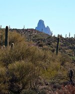
In my opinion the photo below might be very close to the view of Weavers Needle that Jacob Waltz once had from his gold mine. The photo was taken with no zoom.

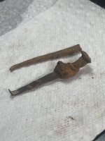
In November of 2015 I was 4 meters underground in a cavity, this what I found.
Not every legend is a myth. 10/12/2016
After Jacob Waltz would leave the trail it would take him about 30 minutes before he would have to make a right turn and headed south at this point he could look down and see if any person or persons were lurking near his mine. This point is about 300 feet higher than the mine entrance. In my opinion this is the only trail that Jacob Waltz could take or would take to his mine. There is no way that Jacob Waltz came in from the east or west because he would be wide open for any person to see him and I think Jacob Waltz knew this very well. If Jacob Waltz came in from the south he would have been ambushed very easily. The only safest way into the mine was from the north.
Many years ago in my home country which is southern Germany not far from the border of France there was a rumor and maybe still to this day that Jacob Waltz had built a stone house in a canyon. They say Jacob Waltz had built this stone house over the portal or entrance to his mine. The reason I would bring this up is because earlier this year I came across a small foundation measuring 22 feet x 35 feet which equals to a total of 770 square feet. The foundation faced the northwest. I don't know who built this small house. I thought it was weird to have built a house in this box canyon with only one way out. In those days I would think that would be suicide unless you had a very good reason to build a house right there. The stones laying around this foundation don't match the surrounding stones. These stones are a lot smaller in size. The only thoughts I have is they might have come from digging/tunneling. What better way to remove and hide tunneling rock by building a stone house right over the mine. By the way there is a rather large stone heart that measures almost 10 feet across and almost 10 feet long. This stone heart lays behind the old foundation, the heart is cracked on the left as you look at it. You can only see it is a heart by looking at it from one angle and of course the heart faces west. This heart would have taken several men to move into this position. I doubt if it has ever been moved since. I would think the stone house would have covered up the stone heart if the stone house had walls 6 feet or higher. I have not found any logs laying around. If you climb up about 80 feet above the old foundation you can see Weavers Needle to the south south east. To the west is a small cave about 200 feet away. What really makes me wonder about this place is this. If you walk across to the west climb up on the cliff across from the foundation and look down at the area around the foundation area you can clearly see that vegetation doesn't grow very well.
Where you have read or may have not read this quote by Jacob Waltz. " If you pass three red hills you have gone to far ". This quote is true. It takes about 30 minutes to walk pass these three hills on a down ward slope. The red hills will be on you're right as you walk pass them. Once you have passed the three hills you should be 15 minutes or less from the gold mine. It's easier going walking in on the right side than if is on the left. This is very rough ground. Once you have reached the front of the gold mine when you're standing there you will think you're standing at the bottom of a funnel when you look up and all round. And you will understand why Jacob Waltz only went to the gold mine when he thought the Apache were not in the area. During the Fall & Winter season you will not have sunshine on the gold mine entrance after 4:30pm because of the hill to the west.
What I know to be the truth to me is this. I know the Peralta stone maps are a copy from a original map that the Peralta family once owned and had in it's possession exclusively. On one of the stone maps toward the bottom it has the numbers 2=3-O (doughnut looking zero or the circle within the circle) this is telling me that the gold mine is in the funnel shape box canyon. This also tells me that if you leave the trail and make two turns and then you stop in the third turn you will find the gold mine. The number " 18 " on the Peralta stone map I will not discuss. The number 7 on the stone map is what the Peralta family called this gold mine. The mine was called this to honor the seven Peralta family members had lost their lives while the family was working the mine. This must have been some gold mine. After all of the death in the family the gold mine was given up and the new owner was to become Jacob Waltz. What I have just mentioned above can not be made up. I have physically been there time and again. I have stood there inside the funnel shaped box canyon and wondered if and where I have I miscalculated anything at all. Is this where the trail ends ? I think it does. This has been a long time coming. From the old spent cartridge rounds I have found inside this box canyon some one or some people were protecting something for a reason. One other thing that I have thought about for some time is this. How could Jacob Waltz come and go from the gold mine without being attacked by the Apache Indians ? The Apache's did shoot Jacob Waltz in the left shoulder with a arrow. At that time I think that the Apache's thought they had killed Jacob Waltz. I think that the Apache's found out later Jacob Waltz was still alive and the Apache's were scared of Jacob Waltz because the Apache's could not kill this white man and from that point on they would not bother Jacob Waltz because maybe he could kill them instead.
I believe that the Peralta family was in the Superstition mountains long before 1847. I would guess they arrived around 1840 or so.
I think the reason that the person made the Peralta Stone maps for the Peralta family was due to the large gold discovery of what we call the Lost Dutchman Mine today. I also think that the Apache Indians main camp was not to far the south of Weavers Needle. This way the Apaches could keep watch on the Peralta miners. If the Peralta's were packing gold out of the Superstition Mountains the Apache were going to make sure it never made it to Mexico. The Peralta's would have to pass by the Apaches sooner or later. I don't think the Apaches were going to let Peralta miners leave the Superstition Mountains dead or alive. The Apaches knew the Peralta's were weighted down heavy with gold and were going nowhere fast.
I stated earlier that I didn't want to discuss the number 18 because I didn't know the answer. The 18 holes on the Peralta Stones represents 18 mines I believe. I think most of these mines were small mines. I think the person that made the Peralta Stone maps wanted to make people think it was a trail if the Peralta Stones fell into the wrong hands. The 18 holes in a trail as far as I can see lead to nowhere. It just doesn't make any sense. Like I stated before the number " 7 " on the Peralta Stones represents the Lost Dutchman Mine. The Peralta Stones states this place is dangerous. The Peralta Stone map that has a Priest standing on top of what it looks like to be on top of stairs. I believe the " 7" gold mine was blessed by a Catholic Priest at some point in time and Weavers Needle over looks the number " 7 " gold mine. The Priest is wearing a sombrero which looks like Weavers Needle.
Of all the maps that I have ever looked over. This is one interesting map. I believe this map is a real Peralta map. The salt river is to the north and map also has the four peaks above the salt river and Weaver's Needle is to the south.
At the top of the map it says " El Terrot of de los mine oro apache " and translates to " The Terror of the Apache gold mine ".
At the bottom right of the map it is signed " es ti augo " which translates to " is your friend " Manuel Peralta and has a date of 1848.
If you look at the Peralta Stone Map that has ten holes that are connected together. To the right of these connected holes you'll see a large looking " F ". In my opinion this is " Weavers Needle " up right. If you tilt you're head to the left and look at this figure it looks like " Weavers Needle ". Also this is located on the right side of the Peralta Stone Map as you look at it, which to me means it would represent being to the south. If this is Weavers Needle the myth holds true that the Lost Dutchman Mine is located north of Weavers Needle according to the Peralta Stone Map. To the left of the " F " AKA Weavers Needle is a pair of zeros together at a angle that look like eyes looking down from Weavers Needle. To the left of the eyes looks to me as this figure represents mountains and then to the left of this is a T-Pee. All of this reversed and combined tells me that the Apache are watching from the mountains to the south by or on Weavers Needle.
The image below was supposedly drawn by Jacob Waltz before he died. If this true, I believe I'm in the correct area of the Lost Dutchman's Mine. There is only one Weaver's Needle in the Superstition Mountains. The drawing shows a tall point to the south which would be Weaver's Needle and that could only be the right side of the drawing, which the drawing is. The gap to north of Weaver's Needle must be the Military Trail that travels north & south. In front of Weavers needle and to the left of the Military Trail Weavers Needle in the drawing has to be Bull's Pass if am reading the drawing correct. The Lost Dutchman Mine should be just north of Bulls Pass.
In my opinion the photo below might be very close to the view of Weavers Needle that Jacob Waltz once had from his gold mine. The photo was taken with no zoom.
In November of 2015 I was 4 meters underground in a cavity, this what I found.
Not every legend is a myth. 10/12/2016
Amazon Forum Fav 👍


Attachments
Last edited: