You are using an out of date browser. It may not display this or other websites correctly.
You should upgrade or use an alternative browser.
You should upgrade or use an alternative browser.
Just Drill Holes
- Thread starter dsty
- Start date
.webp")

.webp")
.webp")
.webp")
.webp")
.webp")
.webp")
.webp")
")


dsty
Bronze Member
- #102
Thread Owner
Hello eve, Very Good Post, looks like you have found a yard ( bunch of stuff in one area ) I think those type things are meant to confuse, the ones that I have seen are between the Windrose's so if it was me I think I would get a cool drink of water and just sit down and see what looks strange a couple hundred yards down hill, I would look toward the South East first, perhaps a triangle, square, rectangle, they probably will be different sizes, one may be sitting where its on level ground with a 4 inch drop off on the down hill side ( kinda like it will sitting on a ledge ) ( trap if you are standing in front of it it will get in your lap real quick ) the distances between them should be a cordell ( 190 ft ) or portions + or - kinda like 1 1/2 cordel,
Shortstack
Silver Member
- Joined
- Jan 22, 2007
- Messages
- 4,305
- Reaction score
- 419
- Golden Thread
- 0
- Detector(s) used
- Tesoro Bandido II and DeLeon. also a Detector Pro Headhunter Diver, and a Garrett BFO called The Hunter & a Garrett Ace 250.
- Primary Interest:
- All Treasure Hunting
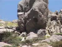
This has a bible verse on it. It reads J 10-2 or John 10-2. The two rocks laying just right and high of center on the skyline make it up.
They first make the number 10. The shadows on them also make the J and number 2.
So it may not help you any, but here is J 10-2 :
"But he that entereth in by the door is the shepherd of the sheep."
There is a small shadow "dash" or line to a very large "5" below that, so it is telling you verses 2-5. So you have these verses as well:
To him the porter openeth; and the sheep hear his voice: and he calleth his own sheep by name, and leadeth them out.[SUP]4 [/SUP]And when he putteth forth his own sheep, he goeth before them, and the sheep follow him: for they know his voice.
[SUP]5 [/SUP]And a stranger will they not follow, but will flee from him: for they know not the voice of strangers.
There are other signs telling you to do things in this pic as well , and in the other pictures, but it would be a bit to figure it, and you need to have a wider view of what is going on.
These are called "John" sites, and you are in a yard. They are difficult if not impossible to figure out.
I'm thinking that that large "X" figure just to the left of center has distance and depth values associated with it. It is made in a sensationalized manner, so the 4 "V" sections would equal "20" then add the "X" value of "10" for a total of "30" for the distance. Then, the three sections formed by stone give a value of "15" for depth. Now, I could be totally WRONG or at least partially right........not sure, but it sure seems logical. The 2 lower "legs" of the "X" are exaggerated and meant to draw attention. They could have just chiseled a whole, segmented "X" on to the face of that larger rock, but didn't because it was easier to do it this way with the added depth value being obvious. Again, I could be wrong, but it just "feels" right.

dsty
Bronze Member
- #105
Thread Owner
Hello Eve, that opening that your looking into looks simular to some that I've seen that had a statue of the Virgin Mary in it, if it is it may look toward the South East and there may have been a removed statue in it, by the church, may have been buried, ( theres a couple of places to look ). If you wish to get serious with it a PM will work, I have a couple of ideas
Last edited:


dsty
Bronze Member
- #107
Thread Owner
Hello Eve, from what I believe what's avaiable on some of the sites thatI have seen is that, size matters for distance and directions, I would group and size them as seperate directional indicators, its my belief that 70 inches = 1 league / 2.5 miles, if you have something thats 24 ft high / long then its telling you 10 miles in the direction it shows ( this is where a county map comes in handy ) and I would think that something may be in the area such a cache, cache sites seem to have knee high, waist high seem to indicate 1320 feet, ( 1/4 mile or seven cordels ) 14 cordels = 1 1/4 mile or 1/2 of a league, windrose are important and the ones that I have seen are 3 cordels and less ( 600 feet ) and fractions of cordells between the corners and use the perfered compass directions such as 320 degrees is one that I have found a lot of. Kim (Desert Moon ) has a lots of large monuments along with lots of others Thom, Rangler for a couple more, I wish someone would verify that thought. Anyway I will look at the new ones posted, I believe that I have had one person that verfied a distance / direction when they posted a marker. Thanks
dsty
Bronze Member
- #109
Thread Owner
Hello Folks, well Tinhorn came by and we had a couple of good evenings just visiting about things that seem to be working toward some things of a historical nature, we agreed on several points lots of you guys and gals entered into the conservation in a good way and especially those that have helped to make this site helpful in so many ways to a lot of folks, most of all, the markers that's been posted. His father-in-law sure makes some GOOD hot links. I'll think of everybody when I get the grill fired up. Would sure help if we had some compass degrees and height, length width. There's a good chance that lots of information can be gleaned from them for the good of all.
Last edited:
dsty
Bronze Member
- #110
Thread Owner
Sometimes theres lots of things in the field that match what the Spanish left and what we changed around to fit our needs, sometimes I ask silly questions but I do believe those that came before us left information for us to follow, Gale Shaffer, Kenworthy, and others that found initials that was joined together to mark the section and to give it a number, I do not believe that initals were those that was in charge of the expedition,rather I have found two, one was south of Ringling Oklahoma, it was a U l , the u was laying horzional to make a P. the other one was about 80 miles north and it was a H U which horzional the U made a P, H=8 and U = 21 or 821 for a section number, the one south of Ringling was a l U, to make a P l = 921, I do believe that they used Bible verses out of the Old Testement to indicate something, I believe you can walk around trying to figger what they done and have lots of fun, they left maps for us to follow, Thom, Rangler, Uncle Matt, and lots of others that have shown us, some are a series of dots, some are series of initals, and some are hidden in caves, and its hard to have an opinion if you can't see the symbol very good or just show a portion of something and ask what is this, Lost Horse can I bring your turtle back just so folks can see, Uncle Matt can you send a photo of the entire rock that has the measage on it and its not cattle brands. Time is up gotta go good luck folks

Shortstack
Silver Member
- Joined
- Jan 22, 2007
- Messages
- 4,305
- Reaction score
- 419
- Golden Thread
- 0
- Detector(s) used
- Tesoro Bandido II and DeLeon. also a Detector Pro Headhunter Diver, and a Garrett BFO called The Hunter & a Garrett Ace 250.
- Primary Interest:
- All Treasure Hunting
Wanadig:
Dsty was the first person on this forum to "teach" about drill holes and rangler said that he had not heard of that info before and thanked dsty, as the rest of us did, for bringing out this area of trail following. You'll notice that rangler was posting many, many posts left by dign that included HIS info about drill holes. NOW, was rangler BSing about his lack of knowledge concerning drill holes?..........or, did he go back and "adjust" that previous post?........or..............
Anyway, dsty figured out the drill hole codes, not rangler/dign.
EDIT: And, if you will notice; in that quote of rangler's that you used, he made NO mention of dsty's information or the fact that he schooled rangler along with the rest of us on that subject. Kinda of disrespectful wasn't it??
Last edited:
dsty
Bronze Member
- #115
Thread Owner
Thanks Bill, Theres still so much to learn, as the one that pearl posted it seems that it goes down aways and then changes width which changes everything and I know they carved information in the bottom, around the top edge in a series of pecks and in order to see them you have to use that reverse immaging and paint to enhance what they left, there's so many different types, its very important to carry a can of air ( be careful about your face and especially eyes ) they also used features of the profile of the boulder such as an egg, eagle head, round bottom has a meaning, flat bottom has a meaning, a 3mm drill hole in the botton ( never seen one in the side ) 1 inch in the bottom has a meaning, bottom comes to a sharp point 3 inches across the bottom has a meaning, as far a distance goes its basicly the same pattern as as trail markers monuments, small = short distance, big = long distance, they did use feet, yard, fractions of a cordel, fractions of a league, 7 cordels = aprox 1/4 mile was used on the square league borders, if you are able to see the profile from both sides then its seprerating two square leagues one for each side, if it can only be viewed from one side then thats the one it represents. Its not hard to figure out the property borders that I have seen had waist high flat ( standing on edge ) and waist high boulders that were carved with a profile going both ways and some that have only one way, I think that the heigth ( length if its flat on the ground ) will tell a story of its own or has a reason for being where its at and for what it will tell you, they will put so much in a small and its very confusing for a reason, in my opinion the ones that have E /W / N/ S headings are the ones that very possibly are the ones that you can use, when you find those that are knee high ( horzional / vertical ) may be windrose markers and yes its very possible that the will be included in a yard. I can't get any feed back on what folks find in the field to support what I have seen. It may be too doggone hot, lots of critters, finances, and other matters.
Shortstack
Silver Member
- Joined
- Jan 22, 2007
- Messages
- 4,305
- Reaction score
- 419
- Golden Thread
- 0
- Detector(s) used
- Tesoro Bandido II and DeLeon. also a Detector Pro Headhunter Diver, and a Garrett BFO called The Hunter & a Garrett Ace 250.
- Primary Interest:
- All Treasure Hunting
Dsty:
Is it possible that when there are drill holes in a yard, that if you put straight staffs into each hole, the extended lines of sight could give a dig location. I've read that there are normally no "dig here" signs, but the extended sight lines from drill holes would still support that idea.
Is it possible that when there are drill holes in a yard, that if you put straight staffs into each hole, the extended lines of sight could give a dig location. I've read that there are normally no "dig here" signs, but the extended sight lines from drill holes would still support that idea.
dsty
Bronze Member
- #117
Thread Owner
One that comes to mind that is a corner marker for a windrose that two 3mm holes lined up and was a directional indicator, you can see it at old photos theres lots that I have not seen tho the ones that I have seen in a yard seem to have helpful information such as " here " ( one of the corner markers if its knee high distance, if the direction is in question then something on the rock will indicate that fact. if theres two close together 6 inches between ( 3 mm across ) sometimes they are directional and also depth indicator such as 23 cm / 23 mm indicating 230 cm or 7'7" deep, just a regular 4 inch across / 4 inches deep = 2 or a multiplier and that one will be 34.5 inches around the top X 2 = 69 paces or a cordel ( 189.5 ) I use 190 feet. Most of the first drill holes that I seen was I was with Danny and Don both and they were the 1st ones kick start me and got me thinking about methods and reasons for them. I guess what I'm saying is they were the ones that got me started on drill holes
Shortstack
Silver Member
- Joined
- Jan 22, 2007
- Messages
- 4,305
- Reaction score
- 419
- Golden Thread
- 0
- Detector(s) used
- Tesoro Bandido II and DeLeon. also a Detector Pro Headhunter Diver, and a Garrett BFO called The Hunter & a Garrett Ace 250.
- Primary Interest:
- All Treasure Hunting
Some folks have commented that the Jesuit Codes have not been broken and Old Dog mentioned that whoever DOES figure them out will not have to ever "work" again. Since the drill holes are so unique and have such in-depth coding; do you think that maybe they are a big part of the Jesuits' coding system and techniques or perhaps the center point of their system?? I just have the good feeling that they are NOT part of the original Spanish code book from the King and also, too technical for the different hacienda groups.
dsty
Bronze Member
- #119
Thread Owner
Hello Bill I agree with Thom, It is my opinion that the Jesuit Priest may have used the Kings method, then along came the other folks and used Vikings method with the Drill holes and they are in Fact, Viking Mooring Holes and do not fit with anything the Spanish had going, just they may have sliped in a few drill holes, changed things a little and presto things get all messed up. Just a thought / guess
dsty
Bronze Member
- #120
Thread Owner
Well it seems that after going back and looking at the sites ( from memory ) at the cache sites that are in the NW corner of the league square there some that have 0 drill holes some with 1/ some with 2 / some with 3 / and some that have 4, and the Viking Baths have east of Stoneburg Tx have several, the one that has 1 in a symbol that has a 3/4 boot ( side view )carved aprox 3 inches deep into the profile and the drill hole is at the back side of the boot, My thoughts are that perhaps they are directional when theres more than 1, I guess the 1 would be considered directional using the toe as the direction, at this point it would not supprise me if it indicated an extention of sorts this direcional X 2 or 3 or 4, good grief, Im headed to the liquor store
Top Member Reactions
-
 2193
2193 -
 1599
1599 -
 1392
1392 -
 1234
1234 -
 1212
1212 -
 1058
1058 -
 1007
1007 -
 791
791 -
 772
772 -
 609
609 -
 565
565 -
 539
539 -
 512
512 -
 498
498 -
 483
483
Similar threads
Users who are viewing this thread
Total: 1 (members: 0, guests: 1)
