You are using an out of date browser. It may not display this or other websites correctly.
You should upgrade or use an alternative browser.
You should upgrade or use an alternative browser.
Just Drill Holes
- Thread starter dsty
- Start date


 ??
??dsty
Bronze Member
- #84
Thread Owner
One thing that I have noticed on most all the drill holes that I have seen is that the dirt,-gravel,-covering, has been removed indicating that most have been worked, the ones that are still there will have grass, something growing out of them, I've only seen two and believe me there's lots to know when you find them to get on the trail, if you see a flat rock on top of a larger one look it over, small tuff of grass growing out of a boulder dig it out, it seems that they would conceal the ones they made, much like the depth of a cache takes several measurement to make the depth using the Kings method
Last edited:
dsty
Bronze Member
- #88
Thread Owner
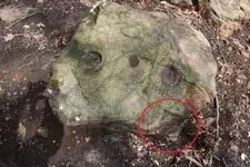
Hello Tinhorn, to me the V that you have circled is a vertical mouth and is probably the best indicator of something postive in the area,all that I have seen is a VERY directional and WILL NOT show anything except either a hole in the ground or a very likely a place that should have a hole in the ground, lots of information needs to be gathered or if you have a light metal detector and enough energy to operate it that will detect ground mineral ( or the Lack of ground mineral makes it null, size of the null should be sommewhere around 7/8 foot across and should be a circle ), and it could be as far as 1200 feet. Those are good drill holes and I would work them from large hole to small hole ( they may be fake / trick also to bring you chaseing your tail ), two directions one goes right and one goes left, measure by the foot looks to be indicated. Need the depth and size of the holes to have any thoughts about distance. The drill holes may be for distance and the V for direction. Good luck
Last edited:
dsty
Bronze Member
- #90
Thread Owner
For those that may be interested, I was looking / researching for a place to look for Gems several years ago and found a place on the internet ( the area may have been in Canada ) and using Google Earth I found a round circle that matched those in Canada just south of Cimmaron N.M. ( may have a few miles 6/ 7 ) on the Boy Scout Ranch. But soon lost interest due to another venture, someone who who may be interested might look for Gem stones in Canada and what I found was that were found in what they called a "pipe", circle that goes stright down into the earth and they were working the ground with huge earth moving equipment, my thoughts were that the "pipe" don't have to be 2 miles across, just 50 feet might yeild some interesting, it would be a good place to get some investors and try, first I would go to a University and talk to someone in the field.( I'm having a slow day )
dsty
Bronze Member
- #91
Thread Owner
There's things that I wonder about in the quest to understand methods / how they put things together when placing the trail markers especially when you follow them from a corner marker, such as methods when a waist high marker is found that may indicate a change of direction just to throw you off the trail but when you follow the required distance also it all fits together. Possibly there will be a a marker thats half way, 1/2 of a league = 1 1/4 mile to indicate the center / middle
dsty
Bronze Member
- #92
Thread Owner
Has anyone out there found a triangle / square / rectangle, layed out and they believe its 1/2 of a windrose, I believe I may have a clue as to how to find the other half really easy distane and direction. I have worked out two that I have, a rectangle and a triangle and found the end with the cache using information off the info of the known half, will PM only, I will not post this information
Last edited:
dsty
Bronze Member
- #93
Thread Owner
These are some of the things that roll around in my head it may help don't know yet and they are just what I have seen and worked out, They did mark a square league at each corner and had waist high markers along the trail between the corners, they had cache sites at each one that I have seen, the league is numbered, thed have a windrose on that I have worked from top to bottom, sites are layed out in a triangle / square / and rectangle, the NW corner seems to be the perfered corner. They marked the corners with useful information, the south east corner seem to have information to the layout of the site, the north east corner seem to have info the depth and how its placed in the ground, the north west corner shows the direction and distance to travel and its verivied by information between the corners, add all the distances between the corner markers they will be measured by cordel or portions of cordel, 190 feet / 95 feet and so forth, using direction indicators at the nw corner ( regardless if its a triangle / rectangle / square. an example is 95 ft / 189.5 ft / and 189.5 feet using the direction at the nw corner you will find the first symbol of the windrose, there will only be two and you must locate the others using info off those that you have found, everything works the same regardless if its a trtiangle / square / rectangle, they did use numbers and letters also XX= 1010 feet fron windrose to windrose one is easy and can be measured to use to work the other one, when you find a marker thats knee high look aruund, under, on top, sides, and bottom if two men can turn itover , NEVER pull one standing on the down hill side. OK I changed my mind about not posting this, everything they did using the different layout they could change the distances pretty good. Thats not all but my finger is tired
dog the treasure hunter
Gold Member
- Joined
- Jan 16, 2011
- Messages
- 5,010
- Reaction score
- 5,039
- Golden Thread
- 0
- Location
- By, By Have fun.
- Detector(s) used
- Time to move on. Good luck everyone .
- Primary Interest:
- All Treasure Hunting
very good info. dsty. thanks for posting it. I like your style of searching out of all the different methods used. its the one I want to learn to use. iam sure others are good too, and will get you there. I just prefer your system, for some reason, iam drawn to it. iam always saying to my self, man that's good and makes sense. even though iam a long ways away from taken it full circle and coming home with it. I believe you are right about the cache sites being at each league. I believe there are a lot of cache sites out there, I know I have found a lot of them, i just haven't got good enough yet to pin point the X spot. and they are about that distance apart in the mining areas I search in.so don't give up guys, its there, more then what a lot of people think. yes some is gone. but still ALOT LEFT, i believe anyways. whats your thought on a square or rectangle that is propped up verses one set flat, dsty? its ok if you don't want to say. you have given a lot away for free already. thanks dsty. I really like you system. good stuff, thumbs up. 
dsty
Bronze Member
- #95
Thread Owner
Hello dtth, some that I have laying flat one had a T sticking out of the NW corner, it was 5" X 7", and I believe it to be a dig here sign, something in the NW corner, just a square or a rectangle carvings to me something to look for = 4 corners, something to look for may be something showing the direction, if you can't find a direction indicator then look around you may already be there. I use 190 feet per cordel theres only 6 inches difference between 189,5 and 190 and if I can get that close I can find it. To me the Alpha and Omega can be the start / end and anything can show that, I believe the ones that carry the most interest are 330 degrees and reverse, 30 degrees and reverse. > I agree there was so many and I DO NOT believe they got them all but you must use all the information avalble to increas your odds, thats what I'm trying to do, find yourself a corner marker and there may be small knee high boulders in the area with symbols, just grin and go to work, theres some more tools that will be useful to use, draw out 10 boxes along the top and 10 boxes vertical fill out the sheet untill you have 100 boxes 7/8 " X 7/8 " each one will represent 1320 feet or 1/4 mile. My time is up
dsty
Bronze Member
- #96
Thread Owner
Back to your map if you look at the 10 boxes X 10 boxes and you have a corner marker use that to make a mark in the upper left hand side and that indicates NW corner, if you make a spare copy and make a plus sign seperating it into 4 parts that will give you 25 leagues square, each with 5 rows of square leagues make 4 copies and place them at each side once more the upper left hand side to indicate your corner marker, using that method you can go to each league and find the NW corner with out doing all that silly walking around, I don't remember who posted the windrose and I do wish to thank him for his contrubition, I do believe that all they did have some modified version of the windrose as far as distances and direction, mine , cache sites , and vaults. I believe the churches were in the center of the 5 league square, and probably will be something as a cross to mark it as a place of worship and cemetery, cermonies. 1st map 100 squares 1320 feet each 2nd map 25 leagues square and so forth, I stay with 7/8 inch because of the 7 cordels, my brain is running out of numbers
dsty
Bronze Member
- #97
Thread Owner
In my opinion the US suveors layed out sections from the West to the East because how they are numbered, 36 sections to a TWS I believe Some started East to the West and from the South to the North, To check this out if you have a monument Scale from a good size River East / West or North South and see how many leagues it is to your monument using 12.5 miles = 5 leagues, if you go to the trouble to do that you will know more about where you are at on a master map. This just my thoughts that I also think that if you have a huge face on a bluff you can scale it by using the 6 ft rule 6 ft = a league, 36 ft high top to bottom 6 leagues. Just a thought
dsty
Bronze Member
- #98
Thread Owner
I have seen photos of a V with another one turned upside down on top of it, I wonder if because its got a diamond in the middle that tells you to go 2.5 miles in each of 4 directions that the legs indicate, same thing with the W on top of upside down W and it may indicates 5 miles, Sometimes I wonder if they didn't skip an area that was too barren, desert too dry, swamp, rocky hills, all of which would not be a useful piece of property
dog the treasure hunter
Gold Member
- Joined
- Jan 16, 2011
- Messages
- 5,010
- Reaction score
- 5,039
- Golden Thread
- 0
- Location
- By, By Have fun.
- Detector(s) used
- Time to move on. Good luck everyone .
- Primary Interest:
- All Treasure Hunting
that's some good stuff dsty, thanks for posting it. iam still looking on line for some 7/8 lnch block paper to take out in the field for grid papper, l want to see how things work out,on paper. I like your system on this. I think iam gonna start with this tunnel sign you spoted for me, iam gonna use a range finder from the tunnel sign to some other signs, get the distance and deg.heading.and put it on the grid.View attachment 812301View attachment 812301
dsty
Bronze Member
- #100
Thread Owner
Hello DTTH, I had to make mine using an artist sketch pad from wal=mart or staples, the tunnel symbol seem to be knee high which it may be a corner of your triangle / square / rectangle . The two hand drawn squares I made for my use I used 7/8 because of the 7 cordells seems to work best, 1320 across the top 10 squares as being 1/4 mile and marked them as such skiped a line and marked the next as 2640 feet because I believe the line between the corners will be marked at 1/2 mile, perhaps 1 1/14 or half way also have a different higth. Then the others below I marked at 2.5 miles or a league which would be wonderful because if you have several monuments and they are severl miles apart you can go 7.5 ( 3 blocks ) miles East and then go 5 blocks north to check your monument ( all monuments may not be corner markers, depends if the profile fits, if the heigth fits or if its just a big rock )
Top Member Reactions
-
 2205
2205 -
 1596
1596 -
 1394
1394 -
 1243
1243 -
 1203
1203 -
 1061
1061 -
 1003
1003 -
 787
787 -
 784
784 -
 612
612 -
 570
570 -
 539
539 -
 519
519 -
 498
498 -
 483
483
Similar threads
Users who are viewing this thread
Total: 1 (members: 0, guests: 1)
