

- #1
Thread Owner
[h=1]Nat Geo Launched a Free Website for Printing Detailed Topographical Maps[/h] AUG 06, 2016
DL CADE
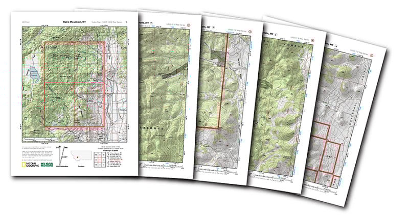
The folks at National Geographic just did a solid favor for all the adventurous outdoor photographers out there. They put every US Geological Survey (USGS) topographical map from across the United States on one easy-to-navigate site and made them easy to print out at home.
If you’ve ever gone hunting topo maps via the USGS, you know that it can be a bit of a pain because, not only is finding the quad you’re looking for more difficult, the PDFs they have available aren’t formatted for standard printer paper.
The National Geographic website solves both of these issues. First, the homepage greets you with a searchable, interactive map: all you have to do is search for or zoom in on the area you’re looking for. Then, once you find your quad, just click on it and a printable PDF loads right up.
It’s incredibly easy. I pulled this one up in a matter of seconds.
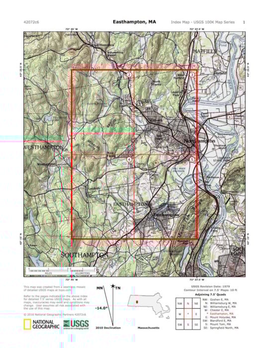
The printable PDF you get from Nat Geo is broken down into 5 pages. Page 1 (seen above) is the quad in context; Pages 2-5 are the USGS Quads with one quarter on each page so you can print the whole thing on your office printer instead of going to a print shop.
Finally, National Geographic added one more touch to their version: hill shading was added to each quarter so you can better visualize the topography.
This isn’t going to be useful for all photographers, but if you’re a landscape or nature photographer in the United States who likes to rough it, it makes finding and printing these incredibly detailed USGS maps a breeze.
Link address for the maps... PDF Quads - Trail Maps
Nat Geo Launched a Free Website for Printing Detailed Topographical Maps
DL CADE
The folks at National Geographic just did a solid favor for all the adventurous outdoor photographers out there. They put every US Geological Survey (USGS) topographical map from across the United States on one easy-to-navigate site and made them easy to print out at home.
If you’ve ever gone hunting topo maps via the USGS, you know that it can be a bit of a pain because, not only is finding the quad you’re looking for more difficult, the PDFs they have available aren’t formatted for standard printer paper.
The National Geographic website solves both of these issues. First, the homepage greets you with a searchable, interactive map: all you have to do is search for or zoom in on the area you’re looking for. Then, once you find your quad, just click on it and a printable PDF loads right up.
It’s incredibly easy. I pulled this one up in a matter of seconds.
The printable PDF you get from Nat Geo is broken down into 5 pages. Page 1 (seen above) is the quad in context; Pages 2-5 are the USGS Quads with one quarter on each page so you can print the whole thing on your office printer instead of going to a print shop.
Finally, National Geographic added one more touch to their version: hill shading was added to each quarter so you can better visualize the topography.
This isn’t going to be useful for all photographers, but if you’re a landscape or nature photographer in the United States who likes to rough it, it makes finding and printing these incredibly detailed USGS maps a breeze.
Link address for the maps... PDF Quads - Trail Maps
Nat Geo Launched a Free Website for Printing Detailed Topographical Maps

















