Natural or Man Made?

GoDeep

Bronze Member
Nov 12, 2016
2,120
4,515
Detector(s) used
Whites, Garrett, Minelab
Primary Interest:
All Treasure Hunting
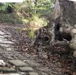
I don't know anything about the site either, but I've seen plenty of boulder fields, and this looks like a not very weathered one. Also misleading is that it's pretty level - often these bedding planes are tipped, sometimes flipped, by other geological processes.

Also, if there was a Native American civilization in Ky that was building paved roads, we'd have heard of proportionate cities at opposite ends of them.

This is just a layer of rock - probably limestone - laid down level from its sedimentary beginning. Erosion opened it back up, and expansion/contraction from freezing and cooling created tiny cracks. Water starts to flow through, enlarging the gaps through erosion. Eventually it would end up as round boulders, but we happen to be seeing it just at the right moment for it to look deceptively like a road.

Here are a few sample pics of similar formations from around the world, from a web search on "jointed limestone erosion".

View attachment 1927594 View attachment 1927595 View attachment 1927596 View attachment 1927597 View attachment 1927599 View attachment 1927600

I stand absolutely positively wrong. You have persuaded me with the evidence you've presented.

One observation though, this has been cleared of the top soil and is maintained. Not one single weed popping through a crack in the middle of a deciduous forest? Unless it was just uncovered of the top soil.
 

Last edited:

ArthurEvans

Jr. Member
May 10, 2016
27
35
Ulster County, NY
Detector(s) used
Garrett AT Pro, AT Max, Ace Apex;
Tesoro TejĂłn
Primary Interest:
All Treasure Hunting
I stand absolutely positively wrong. You have persuaded me with the evidence you've presented.

One observation though, this has been cleared of the top soil and is maintained. Not one single weed popping through a crack in the middle of a deciduous forest? Unless it was just uncovered of the top soil.

I agree it's odd there aren't any weeds... I think you're right about somebody maintaining it!
 

Tpmetal

Silver Member
Jan 4, 2017
4,437
7,561
Western ny
Detector(s) used
equinox 800, Whites mx sport, Garrot carrot, bounty hunter time ranger
Primary Interest:
All Treasure Hunting
Interesting, without more info it could really go either way in my mind. We would need to dig back and check other areas. I have seen both natural and man made just like this.
 

Hal Croves

Silver Member
Sep 25, 2010
2,659
2,695
I stand absolutely positively wrong. You have persuaded me with the evidence you've presented.

One observation though, this has been cleared of the top soil and is maintained. Not one single weed popping through a crack in the middle of a deciduous forest? Unless it was just uncovered of the top soil.

Yes, hats off to AuthurEvans for taking the time to post an intelligent explanation.

But cheers to you for having the confidence to rethink your position, and doing so socially. It speaks volumes about you.

If you want more compelling proof, look at the way individual stones are shaped to fit adjoining stones. That’s the tell. No one in their right mind would expend the time and energy to carve such complicated, interlocking shapes for a road. Shaping architectural stones this way was done historically in Egypt and around the world, but the goal was to achieve tight tolerances. Our “road” stones have a 3-4” gap, consistently, in each photograph.

Yes, the area has been cleared at some point which is part of the illusion. That bend in the road is another tell. It wraps around a decent sized tree that is no more than a century old. When the area was cleared, the path of least resistance was followed, leaving that old tree standing and working around it. The effect is is similar to
Pareidolia, similar, but not exact. An illusion base on visual suggestion. I think that it’s appropriate to post the date of clearing if known.

One last word on the usefulness of Google Earth. Only the gentleman and his friend who owns the property knows the exact location of that “road”. But using GE, someone with time and the need to do so could find it.

Plenty of things have been found using satellite imagery. : )

Cheers!


Last edited:

1320

Silver Member
Dec 10, 2004
3,434
2,308
East Central Kentucky
The lack of weeds shouldn't be perplexing at all. It's bedrock. Weeds need some soil. In the jointed limestone erosion images posted previously, there's also a lack of weeds. The formations are maintained by Mother Nature.
 

KY Hiker

Bronze Member
Oct 28, 2014
1,537
3,220
North Central Kentucky
Detector(s) used
Whites
Primary Interest:
All Treasure Hunting
Hey hope everyone is well. These pictures were sent to me by a woman I work with. She used to own the property this is on. I have never been there. This is close to the Montgomery/Powell County line. Im anxious for some opinions on this! Im leaning toward natural because I cannot fathom what this would be in Kentucky.

I would concur EC Mason, natural formation that gives an illusion of constructed road. It is a sight to see either way. Reminds me of snake head rock near Double Arch in the Red River Gorge. Is all of this creek bed?
 

GoDeep

Bronze Member
Nov 12, 2016
2,120
4,515
Detector(s) used
Whites, Garrett, Minelab
Primary Interest:
All Treasure Hunting
The lack of weeds shouldn't be perplexing at all. It's bedrock. Weeds need some soil. In the jointed limestone erosion images posted previously, there's also a lack of weeds. The formations are maintained by Mother Nature.

Agree to disagree. This is Kentucky, rich soil, deciduous forest that sheds yearly. It's 'seng country. Look at this picture, the cracks are already filled with leaves, those will rot and fill and weeds will spring up within a year in those cracks if not sprayed or cleared. This isn't the arid desert shown in all the other example photos.

Also, look, there's banks on both sides. It's clearly been cleared down to bedrock and photo's compress, it goes back at least a quarter mile and even goes around a corner.

I agree i was wrong that it's not man made, but it's been cleared of top soil by man, the top soil banks on both sides are several feet higher. That is a bet ill take Hal.

I'd suspect she has some on her land and the formation extends into some sort of park. Somebody has to know exactly where this is.

Click to enlarge:

debris.jpg
 

Last edited:
May 2, 2021
4
11
Colorado
Detector(s) used
1977 Sears
Primary Interest:
All Treasure Hunting
Just gonna throw this out there. In researching my ancestry I came across a man in Kentuck that spent a good portion of his life paving a road, circa early 1800’s. He was a bit eccentric as well as dedicated. This thread reminds me of his endeavors.
 

KY Hiker

Bronze Member
Oct 28, 2014
1,537
3,220
North Central Kentucky
Detector(s) used
Whites
Primary Interest:
All Treasure Hunting
Good luck searching with Google Earth, the county lines mentioned extend about 20+ miles as I recall.
 

OP
OP
EC.Mason

EC.Mason

Hero Member
Feb 6, 2009
664
1,030
West Liberty Kentucky
Detector(s) used
Garrett AT Max
Primary Interest:
All Treasure Hunting
Hey all, thanks fir all the insight. Like I said I’ve never visited the place but have permission to do so. I wouldn’t mind a bit to take anyone along. I’m more on the side of it being natural but found it intriguing.
 

GoDeep

Bronze Member
Nov 12, 2016
2,120
4,515
Detector(s) used
Whites, Garrett, Minelab
Primary Interest:
All Treasure Hunting
Hey all, thanks fir all the insight. Like I said I’ve never visited the place but have permission to do so. I wouldn’t mind a bit to take anyone along. I’m more on the side of it being natural but found it intriguing.

Do you have any more information on it's location? Anything on it's history?
 

KY Hiker

Bronze Member
Oct 28, 2014
1,537
3,220
North Central Kentucky
Detector(s) used
Whites
Primary Interest:
All Treasure Hunting
Do you have any more information on it's location? Anything on it's history?

The county lines mentioned extend Westward and is just West of where the mountains begin to rise in the Daniel Boone Nat'l Forest and Red River Gorge region. Some geologist could probably explain the natural processes that would have made this type of formation IMO.
 

GoDeep

Bronze Member
Nov 12, 2016
2,120
4,515
Detector(s) used
Whites, Garrett, Minelab
Primary Interest:
All Treasure Hunting
The county lines mentioned extend Westward and is just West of where the mountains begin to rise in the Daniel Boone Nat'l Forest and Red River Gorge region. Some geologist could probably explain the natural processes that would have made this type of formation IMO.

I did find a link on how it can be formed, interesting: https://en.wikipedia.org/wiki/Limestone_pavement

This is just some of the best formed of any pictures i can find in the world. That being the case, this has to be known, at least among those who study and find these formations interesting. I wonder if this is really in Kentucky? I do see what i believe are maple and oak leaves, which is consistent with KY deciduous forests.
 

Hal Croves

Silver Member
Sep 25, 2010
2,659
2,695
I did find a link on how it can be formed, interesting: https://en.wikipedia.org/wiki/Limestone_pavement

This is just some of the best formed of any pictures i can find in the world. That being the case, this has to be known, at least among those who study and find these formations interesting. I wonder if this is really in Kentucky? I do see what i believe are maple and oak leaves, which is consistent with KY deciduous forests.

Unless some clever sod was able to extract the photographs metadata, only EC. Mason should know.
$100 says the location is in Kentucky.
 

GoDeep

Bronze Member
Nov 12, 2016
2,120
4,515
Detector(s) used
Whites, Garrett, Minelab
Primary Interest:
All Treasure Hunting
Unless some clever sod was able to extract the photographs metadata, only EC. Mason should know.
$100 says the location is in Kentucky.

I already tried that, no location meta data on them. :-(
 

Hal Croves

Silver Member
Sep 25, 2010
2,659
2,695
Hey all, thanks fir all the insight. Like I said I’ve never visited the place but have permission to do so. I wouldn’t mind a bit to take anyone along. I’m more on the side of it being natural but found it intriguing.

Permission from the current owner or your friend who once owned the property?

Regardless, if you go, take some decent closeups of the stones and please let someone know where you are going, especially if alone.

Can you settle the question as to when and if the site was cleared by people?
I have a guesstimate date.
 

Hal Croves

Silver Member
Sep 25, 2010
2,659
2,695
Hey all, thanks fir all the insight. Like I said I’ve never visited the place but have permission to do so. I wouldn’t mind a bit to take anyone along. I’m more on the side of it being natural but found it intriguing.

Its natural, but this little tease isn’t.


attachment.php
 

Attachments

  • 3C7A894D-88E4-47F7-9123-F560C26E5801.jpeg
    3C7A894D-88E4-47F7-9123-F560C26E5801.jpeg
    808.5 KB · Views: 232
Last edited:

Hal Croves

Silver Member
Sep 25, 2010
2,659
2,695
It’s either a box, or some type of cut, wooden post.
Note what appears to be writing.

There’s plenty to see in the original photograph.

Edit..

It’s difficult to be certain but I see “gure”, African name meaning “left-handed”.


attachment.php
 

Attachments

  • B0D43504-D087-4C78-B62F-5919415AFACC.jpeg
    B0D43504-D087-4C78-B62F-5919415AFACC.jpeg
    8 KB · Views: 328
Last edited:

Top Member Reactions

Users who are viewing this thread

Latest Discussions

Top