Bigdogdad
Bronze Member
- Joined
- Mar 5, 2012
- Messages
- 1,627
- Reaction score
- 437
- Golden Thread
- 0
- Primary Interest:
- Cache Hunting
- #1
Thread Owner
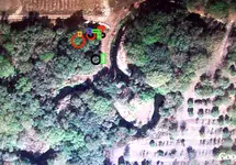
I have a location where I have permission to dig. Different people have been drawn to the same exact location. Map dowsing, remote sensing, LRL and on-site dowsing have all led to the EXACT same place. I took a picture today of the open hole I have dug. It is now covered with large branches to keep the wild hogs from falling in. Before I fill it in I would like to know what anyone on here thinks may be at this spot no matter how small it might be. The other picture is a Google Earth photo that has this location within it. Thanks in advance for any input on this. I am trying to learn. As I have said, four different people working independently have all been drawn to the same spot.


 ??Art
??Art
 ), you get a weak/near/confused beep, try to get close fighting with the detector, stretch and jump ropes to know what is it .. but the reality is that you cant pass the coil over the spot for "accurate identification"

