Dalton Gang possibly buried loot from Adair and Red Rock train robberies near junction of Onion Creek/Verdigris River east of South Coffeyville. Supposedly buried the night before the gang attempted to rob the banks in Coffeyville on Oct 5, 1892.
Stories...rumors...nothing documented or concrete. After his capture after the Coffeyville debacle, he stated that he and his brothers had a total of $900 between the three of them, and planned on a big score from Coffeyville to finance getting out of the country.
Many have speculated that the Daltons had made about $20,000 between the holdups at RedRock, Waggoner, and Adair, and "could not" have spent that much money in the short time period. They deduce that the Gang "must have" stashed the loot they had at Onion Creek before hitting the banks in Coffeyville, to retrieve after their getaway. It is very doubtful they would have buried their loot less than 5 miles from the banks they planned to rob, particularly if they expected any pursuit. More likely they would have stashed any cash they *might* have had near their hideout northwest of Tulsa, in the Sand Springs area.
After his release from prison in 1907, Emmitt Dalton did not return to Coffeyville until 1931...but he was in Sand Springs only a day or so after he got out of Lansing Prison, and only stayed a couple days....
The first time I about that was some article in "True West" Magazine couple years ago. Before that I only had known about the Daltons camping on Onion Creek (actually a couple miles from the Verdigris), before they tried the double bank robbery, but never heard any speculation about any loot buried there. I had always been told the banks were robbed because the Daltons were nearly broke, and wanted to leave the country.
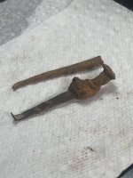
There was a stone found along Onion Creek with "R.D." and a heart carved on it...Bob Dalton decorated his saddle with silver heart conchos...but did HE actually carve the rock?
Another legend/tale about the Daltons is that they had a sister who lived in or around Lenapah, about 10 miles south of Coffeyville. The story goes that after the Adair robbery, two of the brothers visited her (Bob and Grat, I think), and attended a town picnic at "Gooseneck Bend" on the Verdigris River. Evidently this area at the river was a sort of a "park" for the small town. Some newspaper articles tell of picnics and celebrations being held there, but nothing I can find mentions the outlaws. I have forgotten the married name of the sister, perhaps if it could be determined, the area where she and her husband could be found on old land plat maps. The boys may have used her home as a place to lay low after a job...and possibly a place to cache what they had.
"OKLAHOMA CITY, April 28. - Treasure seekers who believe fabulous amounts of gold and silver were buried in Oklahoma and Kansas by the Dalton gang may lay their picks and shovels aside.
Emmett Dalton, 60, last survivor of the band, who now is a prosperous real estate dealer in California, gave information to dispel the fortune hunters’ illusions last night. 'We never buried any treasure,' he said. 'We needed all the money we collected for our own uses, or to lend to our supposed friends.'"
The story of the Daltons stashing their loot before the Coffeyville job makes no sense, really. It would make no sense at all to stash a cache of loot less than 3 miles from where you plan on robbing a bank, and likely attempting to escape a posse. the various stories told by witnesses, and by Emmett Dalton himself, do not jive, so no real determination can be made as to what route the Gang used to enter Coffeyville.
Some stories state the Gang "camped on Onion Creek "near where it joins the Verdigris [River]". On the 1878 map below, Onion Creek can be seen coming down from the west from Fawn Creek Township (Sect 15), then passing to the southeast of Coffeyville, into Indian Territory (OK), where it joins the Verdigris about a 1/4 mile south of the border (below Sect 18 of Cherokee Twp.). The location of the two banks in Coffeyville is very near where the railroad tracks coming from the north intersects the meridian line near the center of the town's cross-hatching.
Several witnesses, testifying at Emmett's trial soon after the Coffeyville Raid, stated they saw a group of 5 heavily-armed horsemen (some said 6) enter town on Eighth Street from the west. They assumed the group was a U.S. Marshall and deputies headed for Indian Territory. (on the map, 8th St corresponds with the heavier meridian line just above the "Osage Diminished Reserve" line).
In Emmett's two books that he wrote ("Beyond the Law" & "When the Daltons Rode"), he reminisced about "riding past his family's old home" which is located at the extreme south edge of Coffeyville (512 Kansas Street, and still standing) , just above the "fork" in the railroad tracks on the map.
The story of Mary Brown hearing riders talking from "under a bridge over Onion Creek" is not clear as to which of the several Onion Creek Bridges this was. At that time there were five, that I can find. One was southwest of town, just under the "LL" of "Coffeyville" on the map, two others due west of town (near the "CO", and "E") another one farther west of town, in Fawn Creek Twp (Sect 25) and another due south of town about 100 yards north of the Border (Parker, Sect 13; the road was built after this map was drawn).
Another account tells of "the afternoon of October 4, 1892, a group of men cut a barbed wire fence and rode their horses across a plowed field, five abreast, to some timber near Onion Creek on a farm located three miles southwest of Coffeyville. They tied their horses to separate trees and prepared to camp." The account further states that the next morning, they "...followed their tracks back over the plowed field to the bank of Onion Creek, where the bridge crossed the stream, then headed north to the trail known as Coffeyville’s Eighth Street. Here they turned east..."
Everything is open to interpretation, of course. More evidence seems to indicate the Dalton Gang DID NOT stash any loot anywhere around Coffeyville.
For those interested, the map shown was drawn in 1878, 7 years after Coffeyville was incorporated (founded in 1869), and 14 years before the attempted bank robberies.. To correspond with modern maps, the meridian line passing through town east-to-west "roughly" corresponds to today's highway U.S. 166. Today, U.S. Highway 169 comes from the south, (crossing Onion Creek, but not the Verdigris R.) then angles slightly east on it's way north, crossing the Verdigris right about where the river crosses Sects 30 and 31 in Cherokee Twp., passing about 2 miles east of the town of Liberty. The "Osage Diminished Reserve" Line is the original, mis-surveyed southern border of Kansas, 2.5 miles north of where the actual border with Oklahoma is now. This is also why there is a "step" in the city limits shown on the map. This line roughly corresponds with today's 13th Street in Coffeyville.


.jpg")