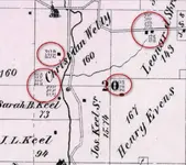
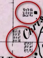
Forgive me for being a little off topic. Looking at an 1875 map I see what looks like an agricultral feature next to the homes. Curious as to what exactly these are. Orchards, gardens, plowed field?
Other thoughts:
Contact the Planning Dept. of your county--with your map. See if they can overlay it with current map. (as mentioned above).
OR
Contact your county's historical society and ask them:
Located in the Library of the Tuscarawas Campus
Kent State University
330 University Drive NE
New Philadelphia, Ohio 44663
Their stated purpose is "to stimulate interest and encourage research in local history; to locate, mark, and commemorate historic sites; and to accumulate and preserve permanent records including pictures, written documents, maps, microfilms, and manuscripts."
Email: tuschs@tuschs.org
Don.........