Possible Bell

:metaldetector:1320: hog branch, 12 French solders and 6 Indians killed on hog branch about 1769. halfway branch, look on topo map for this next part, at top of branch look for small path leading kind of north west. on topo map find small rockhouse just to the northeast, walk in a northeast direction, its about 1 mile. you will see a small flat area where several Spanish were killed by French soldiers. this part I can't say for sure is correct. but when I was there I saw sunken areas and one had bones sticking out. Lester Mullins of long bow boat dock told me about the French solders. at end of
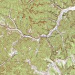
ratliff creek at end on left side is the word oro are ore vary faint. Hiker: the anchor is at end of Clifton creek, look at swift map, you see X at forks, that's tea kettle rock. all the carvings are on it. take west fork or turn right go to end and your standing on the anchor. look at topo map and it shows up like a perfect anchor. tea kettle rock shows several burial places that hides something and also set compass to follow line to mine on second ledge of cliff. from tea kettle the line is 330 degrees.
 

:metaldetector::metaldetector::metaldetector:1320: hog branch, 12 French solders and 6 Indians killed on hog branch about 1769. halfway branch, look on topo map for this next part, at top of branch look for small path leading kind of north west. on topo map find small rockhouse just to the northwast, walk in a northeast direction, its about 1 mile. you will see a small flat area where several Spanish were killed by French soldiers. this part I can't say for sure is correct. but when I was there I saw sunken areas and one had bones sticking out. Lester Mullins of long bow boat dock told me about the French solders. at end of
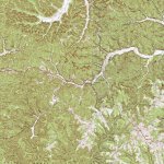
ratliff creek at end on left side is the word oro are ore vary faint. Hiker: the anchor is at end of Clifton creek, look at swift map, you see X at forks, that's tea kettle rock. all the carvings are on it. take west fork or turn right go to end and your standing on the anchor. look at topo map and it shows up like a perfect anchor. tea kettle rock shows several burial places that hides something and also set compass to follow line to mine on second ledge of cliff. from tea kettle the line is 330 degrees.

tea kettle is 1A on swift map.
 

Last edited:
:metaldetector::metaldetector::metaldetector:1320: hog branch, 12 French solders and 6 Indians killed on hog branch about 1769. halfway branch, look on topo map for this next part, at top of branch look for small path leading kind of north west. on topo map find small rockhouse just to the northwast, walk in a northeast direction, its about 1 mile. you will see a small flat area where several Spanish were killed by French soldiers. this part I can't say for sure is correct. but when I was there I saw sunken areas and one had bones sticking out. Lester Mullins of long bow boat dock told me about the French solders. at end of
ratliff creek at end on left side is the word oro are ore vary faint. Hiker: the anchor is at end of Clifton creek, look at swift map, you see X at forks, that's tea kettle rock. all the carvings are on it. take west fork or turn right go to end and your standing on the anchor. look at topo map and it shows up like a perfect anchor. tea kettle rock shows several burial places that hides something and also set compass to follow line to mine on second ledge of cliff. from tea kettle the line is 330 degrees.

tea kettle is 1A on swift map.

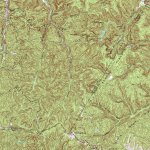
I have the topo map pulled up but it doesn't seem to fit or I am looking at it wrong? Scale and spacing is way off and I don't really see the anchor well.

FrenchburgTopo.jpg

zoomed out

FrenchburgBigTopo.jpg
 

Last edited:
hiker: the first map is showing frenchburg, you need to go right to next topo. next map shows the park and long branch. long branch flows in to Clifton creek. go to end of Clifton where last fork is, go west on fork and topo will show anchor. the fork to end is the anchor. zoom in.
 

OK I see it now, I'm not sure how they did ? Seems I recall you talking about the end of Indian creek and crossing over to Wynn branch in another thread. Was that the same topic or a different one?

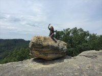
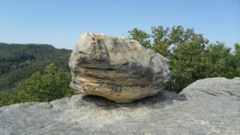
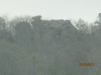
Just SE of Frenchburg is a bluff called Donathan Rock. I think I found a picture of it online, can anyone verify this is Donathan Rock?

DonathanRockFrenchburgKY.jpg

Classic balanced rock ...
 

Last edited:
OK I see it now, I'm not sure how they did ? Seems I recall you talking about the end of Indian creek and crossing over to Wynn branch in another thread. Was that the same topic or a different one?

Just SE of Frenchburg is a bluff called Donathan Rock. I think I found a picture of it online, can anyone verify this is Donathan Rock?

View attachment 1625451

Classic balanced rock ...

Confirmed
 

I used to camp up there when I was younger. There are holes drilled in the top of the rock the balanced rock sits on. It was used back in the day to tan hides.
 

I used to camp up there when I was younger. There are holes drilled in the top of the rock the balanced rock sits on. It was used back in the day to tan hides.

So it is fairly easy to get up on top then? Why would the holes be needed to tan hides? Maybe they were hominy holes like those found in rock houses?
 

Last edited:
So it is fairly easy to get up on top then? Why would the holes be needed to tan hides? Maybe they were hominy holes like those found in rock houses?

The holes were "carved" by someone to scale the small cliff face to reach the "platform" that the balanced rock sits on. Essentially foot holds, small ones at that.
 

Great, thanks!
Any idea how it got or who it got its name from? Donathan = Jonathan?

I have only heard one tale regarding the name of the rock (1980's). A person named Donathan tried to jump from the rock to another part of the cliff top, he failed. More than likely the area was owned by a Donathan Family.
 

Attachments

  • drr.jpg
    drr.jpg
    97.5 KB · Views: 147
  • dr.jpg
    dr.jpg
    75.3 KB · Views: 153
  • drrr.jpg
    drrr.jpg
    61.5 KB · Views: 142
Last edited:
Great Pics 1320. Been a long time since I was up there. The holes are about the size of a quarter or half dollar. They stretched the hides and then tied them down.
 

Great Pics 1320. Been a long time since I was up there. The holes are about the size of a quarter or half dollar. They stretched the hides and then tied them down.

I can't image anyone tanning hides up there...lol. 1. It's physically challenging to get up there carrying nothing. 2. The process of tanning involves water, tannins, etc., vat(s).

I'm certainly not going to disagree with you though, the old timers did things that amaze me. I do know that there was a tannery at the foot of Donathan Rock in the mid 1800's but I've always assumed is was down by Beaver Creek. It's hard to say how they defined "foot of" in those days. Frenchburg was always mentioned as the "head of Beaver" when in fact the true head of Beaver is several miles upstream in the Rothwell Hill area.

I seriously doubt anyone has ever had a detector up there......
 

Great pictures and info, thanks you all. If your not a local, it can be difficult to get straight information (you never know who your talking to)!
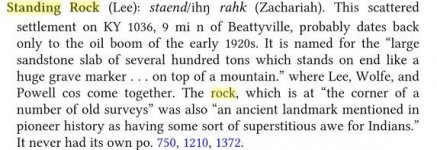
Do either of you guys know anything of or about Standing Rock? Its South of the state park on the Lee-Wolfe-Powell County line not far from Zachariah...I drove thru on a Sunday and there was a small church with the same name having service but nothing obvious of why it got its name. Nothing else was marked and no evidence of a town whatsoever.

StandingRockTopo.jpg
 

Last edited:
Not familiar with Standing Rock personally.

There was a gravel road beside the church and I drove back it about 1/2 mile, nothing there like I expected.... a 'standing rock' was no where to be seen. There was some oil pumps running and an open field area. Interesting it was an Indian landmark though. All I wanted was a picture and a reason for the name, I guess the reason will have to do. I wonder if the rock is in someones' backyard? The description sounds like what I picture as a monument rock or peculiar rock.
Sometimes just reading a map one can find things in plain sight, so when i saw it on a map it sparked my interest.
 

Last edited:

Top Member Reactions

Users who are viewing this thread

Back
Top