Season 4

OP
OP
gazzahk

gazzahk

Bronze Member
Nov 14, 2015
1,718
2,577
Primary Interest:
All Treasure Hunting
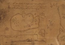
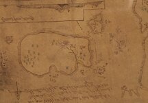
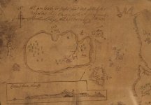
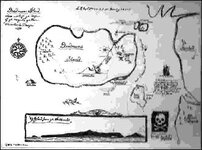
Why this map of Oak Island from 1699 (Halifax Museum) looks so different from now?

View attachment 1387062
Are they sure this is Oak Island. It looks so different from today

oak-island-map2.jpg


Nothing even looks remotely the same ie that other small island. Or is the small island oak island (the one called Booby island it seems pretty similar shape to oak island)?
 

Last edited:
OP
OP
gazzahk

gazzahk

Bronze Member
Nov 14, 2015
1,718
2,577
Primary Interest:
All Treasure Hunting
Additional to what I said in the previous post. The map they introduced in the first episode that they said was from 1347 is much closer to the shape of oak island today and does have the swamp marked on it. Therefore this (if a true map and not just faked) also does not support the shape of oak island in the map above (Unless oak island is actually booby island).
 

OP
OP
gazzahk

gazzahk

Bronze Member
Nov 14, 2015
1,718
2,577
Primary Interest:
All Treasure Hunting
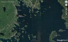
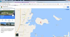
I was just looking at Google earth of the area and it raised some more issues with the theory of big ship coming to oak island

oak-island-GE.jpg

Firstly how deep is the water near Oak Island it seems very close to land was it deep enough to float big ships right up too?

Also these ship captains would of have to sailed past multiple other similar islands ie Tancook Island to get to oak island. What is their specifically about Oak Island that attracted them to it. One would think being closer to land would make it less attractive to hide treasure brought by boats in that people on the land are more likely to notice these large ships anchored close to the island. There seems to be a lot of obstacles for a ships captain to sail his ship right up to oak island.
 

Robot

Bronze Member
Mar 10, 2014
2,033
1,726
Primary Interest:
Other
Could Captain Kidd really have Buried Treasure on Oak Island?

I have always stated that Oak Island was "not" the final resting spot for the Pirate's Treasure of William Kidd better known as Captain Kidd as I never saw any proof of it, until what may be "now"!

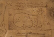
The "Map" introduced by sasqash shows some interesting references that could pertain to Capt'n Kidd.

Oak Island - 17th Century Map.JPG

Maps made by Freemasons and Pirates often were drawn in their upside down position (Turtle) to throw off any observer who may have glanced at a map shown.

I believe once this Map`s Center is Spun Around, and the Map Flipped Over, it puts the Island in its Right Position.

The person who drew this Map only did so to throw off on lookers.

The date "1699" was the time Kidd was pirating and 2 years prior to being Hung.

The Ship shown "Adventure Prize" is very similar to Kidd's Ship "Àdventure Galley"

With these Similarities and locations shown on this Map and if this Map is an Original, then there may be some truth in Capt'n Kidd and the Treasure of Oak Island!
 

Last edited:
OP
OP
gazzahk

gazzahk

Bronze Member
Nov 14, 2015
1,718
2,577
Primary Interest:
All Treasure Hunting
The date "1699" was the time Kidd was pirating and 2 years prior to being Hung.

The Ship shown `Adventure Prize` is very similar to Kidd`s Ship Àdventure Galley`

With these Similarities and locations shown on this Map and if this Map is an Original, then there may be some truth in Capt`n Kidd and the Treasure of Oak Island!
I Thought they discovered this ship last year

Pirate Captain Kidd's 'treasure' found in Madagascar - BBC News
 

sasquash

Sr. Member
Nov 2, 2016
449
425
North of Quebec
Detector(s) used
Computers
Primary Interest:
Other
Additional to what I said in the previous post. The map they introduced in the first episode that they said was from 1347 is much closer to the shape of oak island today and does have the swamp marked on it. Therefore this (if a true map and not just faked) also does not support the shape of oak island in the map above (Unless oak island is actually booby island).

The map reference is from this page:

The Curse of Oak Island- Season 4, Episode 3: Swamp Things - Canada History and Mysteries

"A map of Oak Island on display at the Museum of Natural History in Halifax. Image courtesy of Ryan Phillips"

Yes Booby island looks like Oak Island ...
 

Robot

Bronze Member
Mar 10, 2014
2,033
1,726
Primary Interest:
Other
Pirates Changed Ships...Like We Change Socks!


Yes, It could have been the Adventure Galley which sunk in Madagascar with some of Kidd`s Silver on it, but it appears his largest score was from the captured ship Quedagh Merchant which name was then changed to Cara Merchant and finally renamed Adventure Prize by Kidd.

Quedagh Merchant, also known as the Cara Merchant and Adventure Prize, was an Indian merchant vessel, owned by a man named Coirgi. The ship was captured by Scottish privateer, William "Captain" Kidd on 30 January 1698.

The "Mystery"deepens!
 

Last edited:

Charlie P. (NY)

Gold Member
Feb 3, 2006
13,006
17,114
South Central Upstate NY in the foothills of the h
Detector(s) used
Minelab Musketeer Advantage Pro w/8" & 10" DD coils/Fisher F75se(Upgraded to LTD2) w/11" DD, 6.5" concentric & 9.5" NEL Sharpshooter DD coils/Sunray FX-1 Probe & F-Point/Black Widows/Rattler headphone
Primary Interest:
Metal Detecting
I was just looking at Google earth of the area and it raised some more issues with the theory of big ship coming to oak island


Firstly how deep is the water near Oak Island it seems very close to land was it deep enough to float big ships right up too?

ps anchored close to the island. There seems to be a lot of obstacles for a ships captain to sail his ship right up to oak island.

Best I could do "free". You'll have to zoom in. But it's a nice chart (Canadian soundings are in meters, remember).

i-Boating Web App for Marine Navigation with Marine Charts & Fishing Maps
 

Last edited:

Singlestack Wonder

Bronze Member
Mar 28, 2014
1,711
2,627
Detector(s) used
Garrett AT Pro
Primary Interest:
All Treasure Hunting
The rhetoric that has been spewed millions of times with NO EVIDENCE OF ANYTHING EVER BEING FOUND continues. There is NOTHING to be discovered at oak island except perhaps someone's old privy.
 

lokiblossom

Bronze Member
Dec 4, 2014
1,865
1,310
Traverse City, Mi.
Primary Interest:
Relic Hunting
The rhetoric that has been spewed millions of times with NO EVIDENCE OF ANYTHING EVER BEING FOUND continues. There is NOTHING to be discovered at oak island except perhaps someone's old privy.

Sure there has SW, dated coconut fibre and drilled stones! Enough for me, now New Ross (Charing Cross)!

Cheers, Loki
 

OP
OP
gazzahk

gazzahk

Bronze Member
Nov 14, 2015
1,718
2,577
Primary Interest:
All Treasure Hunting
Best I could do "free". You'll have to zoom in. But it's a nice chart (Canadian soundings are in meters, remember).

i-Boating Web App for Marine Navigation with Marine Charts & Fishing Maps
There certainly is nothing on that chart to support the view that Oak Island used to be two islands that are artificially joined. The water depth looks pretty consistent with it always being one island. Does anyone know how deep those big ships they showed on last episode that they hypothesized that were floated into the middle of the swamp and sunk needed the water to be to sail in?
 

sasquash

Sr. Member
Nov 2, 2016
449
425
North of Quebec
Detector(s) used
Computers
Primary Interest:
Other
Excellent sasquash!

Now, all that is needed is for the Outside Land Mass and the Portion of the Map which Surrounds the Island and Smaller Islands (like a Wheel) to be rotated counter clockwise 180 degrees

Like that ?

oak-island-map2.jpg
 

Roadhse2

Sr. Member
Mar 15, 2015
376
366
Primary Interest:
All Treasure Hunting
" Does anyone know how deep those big ships they showed on last episode that they hypothesized that were floated into the middle of the swamp and sunk needed the water to be to sail in? "

I don't know what they showed...but a typical Galleon of 120 length, 30 foot beam...only needs a 4.5 foot draft to be able to sail...Bigger 3 masted Squarerigged ships, used for crossing the Atlantic as cargo and warships, could have a 10 to 12 foot draft or more, depending on tonnage of the ship...

The Santa Maria, the largest of Columbus ships, was 62' in length, 18' in width, and had a 10' draft, is known as a Carrack and had a crew of 40...the deeper draft made it more stable, but also slower.

So the answer is...could be about any depth of draft, depending on the ship and what it was built to do..
 

OP
OP
gazzahk

gazzahk

Bronze Member
Nov 14, 2015
1,718
2,577
Primary Interest:
All Treasure Hunting
The map reference is from this page:

The Curse of Oak Island- Season 4, Episode 3: Swamp Things - Canada History and Mysteries

"A map of Oak Island on display at the Museum of Natural History in Halifax. Image courtesy of Ryan Phillips"

Yes Booby island looks like Oak Island ...
He posts that map but says nothing about it. I cannot find any other reference to it on the internet. I really wonder why they think it is oak island as nothing about it seems to resemble oak island or the surrounding features. If Oak Island is Booby island on the map then the big land mass would have to be the mainland and not an island at all. As I said I cannot find a single reference to this map in all the other oak island law/legend or any where else on the internet. I would really like to know why the poster of the referenced article thinks it is Oak island and what evidence there is that supports this view. Also weather Oak island is meant to be the big island or booby island. Either way it does not fit the actual land areas that oak island is close to.
 

sasquash

Sr. Member
Nov 2, 2016
449
425
North of Quebec
Detector(s) used
Computers
Primary Interest:
Other
He posts that map but says nothing about it. I cannot find any other reference to it on the internet. I really wonder why they think it is oak island as nothing about it seems to resemble oak island or the surrounding features. If Oak Island is Booby island on the map then the big land mass would have to be the mainland and not an island at all. As I said I cannot find a single reference to this map in all the other oak island law/legend or any where else on the internet. I would really like to know why the poster of the referenced article thinks it is Oak island and what evidence there is that supports this view. Also weather Oak island is meant to be the big island or booby island. Either way it does not fit the actual land areas that oak island is close to.

Ask to Hammerson Peters for the authenticity.

[email protected]

In cant find reference neither only it suppose to be on display at the Museum of Natural History in Halifax.
 

Last edited:

Singlestack Wonder

Bronze Member
Mar 28, 2014
1,711
2,627
Detector(s) used
Garrett AT Pro
Primary Interest:
All Treasure Hunting
Sure there has SW, dated coconut fibre and drilled stones! Enough for me, now New Ross (Charing Cross)!

Cheers, Loki

Again, no factual evidence of a treasure being buried on oak island has ever been produced. The coconut fiber's have been explained many times along with all the other junk dug up for the last 200 years. Some folks here are starting to sound just like finderkeeper, big stories and theories but no proof whatsoever. Templar crosses and drilled stones have been found as far as the western United States. So what...no structures, relics, or treasure has ever been found that could associated with the Templars. If there was such a treasure, it was found long ago and spent.
 

Last edited:

Top Member Reactions

Users who are viewing this thread

Top