Stone Charts of the Superstitions

Status
Not open for further replies.
OP
OP
Hal Croves

Hal Croves

Silver Member
Sep 25, 2010
2,659
2,695
somehiker,
I believe that the maps represent several "lost" silver and gold mines among other things. I have only recently started looking at the story of the LDM, so it is anyone's guess if Waltz was shown one of the mines by a P/M survivor and two companions. There is a good chance that his confession is true. I think that you are at a disadvantage because of your feelings regarding Kenworthy. I have to say that much of his work seems to explain the stones quite well, however I agree that he did not use his own information correctly. Perhaps the presentation Kenworthy made was intentionally flawed to keep things confidential, but accurate enough to sell some books. Anything is possible.

About the Apache... you are correct. It could have been another silver mine, but coincidentally, there are five silver mines represented on the Horse stone. The tracker that was hired followed the Apache into the Salt River Canyon which is North of Globe... Did he go NE or NW? Who knows. If you would and have the time please explain, "BTW:The Salt River Canyon at the heart of the story is not the same river canyon which winds through the Salt River Mountains to the north of the Sups." I am still learning the landscape.

"How would the group which you suspect are responsible for carving the stones,have used them in "ceremonies" ,which I presume are also "secret"? "
Perhaps "ceremonial work" was a poor choice of words. There are secret rituals associated with each of the groups that you mention and they each use similar forms of symbolism to express their beliefs. An encrypted aerial photograph in the form of carved stones seems to fit the idea of the ritual, or the symbolic. How would they use them? I don't know. The whole thing is made messy because of the Tumlinson discovery story. If Travis did not carve the stones, then who discarded them and for what possible reason? In the end I would not be surprised to learn that Travis had carved the stones by simply transferring the imagery from a traditional map which he obtained from his father/grandfather. I just don't have the answer but there are plenty of reasons to suspect a Masonic influence either directly or via a secondary group such as the Mormons.
 

peralta

Sr. Member
Sep 28, 2011
389
45
oahu hawaii
Detector(s) used
Whites 2-box
Primary Interest:
All Treasure Hunting
Hello hal and somehiker, I know that you are very good persons and you both do excellent research.the priest section on the stone is about 50' high.the three steps have three different mines but the stone marking only tells you about the top mine which is called the santa Maria.the priest holding the cross is telling you that the tail of the cross is pointing to the top mine.the triangle on the top of the cross tells you that there are three mines.
The m is the large m that I told you about in the medal we discussed.that same m is in the santa Maria map and it stands below the priest about 12' carved into a boulder.
The peak is just a locator symbol but all the markings the markings on the stones have their place around the peak.you can't enter the santa Maria mine from the top entrance because it was blown and caved in.you need the santa Maria map to locate the m.then you have to break the code on this other map .
In another area is the starting point.look at the arrow with the reversed letter D with the number 11of inside of it.the dagger. Is also visible and is right next to the second mine.the last mine in the triangle is on the horse but I can't describe it to you.the reason I can't is because the person who helped me put the picture of the horse on the net took that information and ran off looking for it.he is a one of the t h on this net.that is why I couldn't help you by posting the priest. Good luck and contacting me and I will help you.if we can meet I will show you all the symbols in the mountains.both of you because your good people.you can both join me on the dig if your interested.
 

somehiker

Silver Member
May 1, 2007
4,365
6,428
Primary Interest:
All Treasure Hunting
Hal:

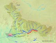
If you simply google "Salt River Canyon",you will find most of the results refer to the upper Salt River.
The Wikpedia Article is fairly concise...... http://en.wikipedia.org/wiki/Salt_River_(Arizona)
This map from that article ,which I have marked in red to show the area referred to,is one which I keep handy when reading the history of the area.
The article also gives a list of past names for the Salt River,but does not include a name by which the lower canyon was once known.

Regards:SH.
 

Attachments

  • 768px-Salt_River_Map.png
    768px-Salt_River_Map.png
    818.7 KB · Views: 617

somehiker

Silver Member
May 1, 2007
4,365
6,428
Primary Interest:
All Treasure Hunting
Hal:

My preceeding posts are not meant to discourage you from investigating your chosen areas of interest,only those tales which I feel are unrelated or too ambiguous to lend creedence to your theories.
Alder Creek and Long Canyon are also historic areas with old mines and ruins dating to times far in the past.I wish I had the time during my own visits,to do more exploration in that area.

I am not surprised that Kurt shares an interest in the area as well.

Mike Burns (Hoo-Moo-Thy-Ah)...http://www.apcrp.org/SKELETON_CAVE/Skeleton Cave Massacre.htm... wrote something in his account of the "Skeleton Cave" massacre,which caught my eye many years ago.He mentioned,as I recall, that the calvary unit which was holding him captive made camp beside the Salt River at a canyon with abundant alders.Using the route followed later by the Lubkin party,and described in the accounts of Rourke,Brown and Burns,I would assume the camp to have been made at the mouth of Alder Creek.What struck me as interesting though,was that Burns also described the area opposite the camp as "enemy's big wash".

That area would have been the wide area sloping down to where Apache Lake Marina is today.

So,who was the "enemy",and what were they doing there for a period of time long enough for Burn's people to have named the wash for them ?

Could the enemy have been Mexican miners,working the wash for placer or operating arrastres ?

I have never looked into it,but which "Brown" was "Browns Cave" and "Brown's Peak" named after.Anybody know?

Regards:SH.
 

coazon de oro

Bronze Member
May 7, 2010
1,625
3,863
texas
Primary Interest:
All Treasure Hunting
Somehiker,

Brown's Peak which is the northern most peak of Four Peak Mountain, was named after Edwin Orpheus Brown. He was an early merchant and farmer, and owner of Brown's Ranch. A lot of good history can be found here: www.scenicdrive.org/dcranch2.htm

Homar
 

somehiker

Silver Member
May 1, 2007
4,365
6,428
Primary Interest:
All Treasure Hunting
Homar:

Thanks for the background and link.
Brown's Cave has some interesting paintwork on the ceiling,a rarity out there.
Been damaged by someone excavating the cave,though.

Peralta:

Sorry to hear that you were taken advantage of.
I think we all have had similar experiences with people we trusted.
I appreciate your offer,but my current project is about all I can handle.
Good hunting.

Regards:SH.
 

gollum

Gold Member
Jan 2, 2006
6,729
7,599
Arizona Vagrant
Detector(s) used
Minelab SD2200D (Modded)/ Whites GMT 24k / Fisher FX-3 / Fisher Gold Bug II / Fisher Gemini / Schiebel MIMID / Falcon MD-20
Primary Interest:
All Treasure Hunting
Peralta,

Do you know for certain that this person ran off with your pics?

I only ask because I get people sending me pics all the time through my website and many times, when I don't see what they do, I get accused of many things.

On the other hand, I have seen (from a couple of folks here on TNet) the willingness to claim jump others and take info given by others to use for themselves. Sucks, but I guess it happens.

Mike
 

cactusjumper

Gold Member
Dec 10, 2005
7,754
5,389
Arizona
Hal,

"Regarding the Apache silver mines... all I can say is that there seems to be evidence to suggest that several silver mines exist in the western (lower) Salt River canyon area, in a location that was inhabited by the Apache. The mines are marked with large alchemy symbols like those we wrote about on this thread... which suggests to me that a group other than the Apache were working the mines... or at least knew of their location."

When you say "Apache silver mines", are you saying that these mines belonged to and were worked by the Apache? If so, which Apache are you talking about?

Thanks,

Joe
 

OP
OP
Hal Croves

Hal Croves

Silver Member
Sep 25, 2010
2,659
2,695
cactusjumper,
"When you say "Apache silver mines", are you saying that these mines belonged to and were worked by the Apache? If so, which Apache are you talking about?"

The story of the "Apache Silver Mines of the Salt River Canyon" was defined long before I began posting, so in fairness I can only guess at which group(s) the author was attempting to describe. From what I can tell, if the native in the story was an Apache and if the location is where I believe it to be, then there is a good chance that he belonged to the Western Apache, or more specifically the Dilzhé`e or Tonto Apache, however since that group seems to have formed a union with the Yavapai, especially the Wipukepa and Kwevkepaya, and because most whites were unable to distinguish the difference then the correct answer may be the Yavapai/Western Apache. Chi lo sa?

Do I believe that they worked these silver mines? I think that to some degree they may have, but it must have been limited to deposits that were easily accessible, so perhaps calling them mines would be a bit too ambitious. Never the less they would have known where to find these "deposits". It would not be a stretch to assume that these locations were (at some point) shared with or rediscovered by non-native miners. As I said the mines are marked with symbols that are not native in origin.

May I ask who do you believe made the symbols at the entrance to Peter's Canyon?
Thanks!
 

OP
OP
Hal Croves

Hal Croves

Silver Member
Sep 25, 2010
2,659
2,695
"[Charles] Kenworthy became a full-time treasure seeker in 1972. He was working on a project south of Tucson in 1978 when he "casually" decided to come to Phoenix to work in the Superstitions. In the Greg Davis collection, there is a video where he explains how he got started. Kenworthy claims that he found the "caverna con casa" in December of 1980 and the Dutchman Mine in 1981. The Arizona Republic ran an article about the discovery on January 25, 1980. The laws at the time said you could mine as long as it was an existing mine. But in August of 1984, the laws changed. The Superstitions became part of the Tonto National Forest. It was deemed "wilderness" property and so you couldn't mine at all. There was plenty of forewarning. Kenworthy knew what he had, he had a staff of able men, and filed a claim in May of 1983. He took $13.5 million dollars worth of gold out of it. Greg Davis confirmed for me that Kenworthy is the only person known to have taken millions of dollars worth of gold out of the Superstitions. The mining claim calls it the "Big D" (named after the big D carved in the side of the mountain). Then he filled in the funnel with rubble and left it. He self-published a book about it in 1997. The book doesn't give the details of the value I just mentioned. This is hearsay from the Tin Man, who should know because Kenworthy's youngest son is his antiquities lawyer. Kenworthy passed away in 2000 and he bequeathed his money to all five sons. The wife is still alive near Los Angeles and she manages the Quest Corporation, the treasure seeking "business" that Kenworthy founded. Maybe someday, they will come out with information and documents about the discovery. (151)"

Treasure Maps of the Superstitions: The Peralta Stone Maps Show a Route to a New and Different Treasure Than the Lost Dutchman's Mine
Amy Michelle Mosier (2006)

I just want to know if anyone on the TN has read this book and if so what are your thoughts on the above quote. Mosier has even shared the GPS coordinates to Kenworthy's mine, which I have posted in the image below. $13.5 million in gold would have been quite a haul to move. Using 1984 as the date, gold was at app. $350 a troy ounce which is $4,200 a pound. Kenworthy would have needed to move app. 3,200 pounds of "processed" gold to make $13.5 million. Was it possible to processed the ore on site? If not the weight must have been considerably more... that is unless he found a cache. Is there any truth to this story? Can someone bring me up to speed regarding Greg Davis? Thanks!


The location "the terrain" just does not appear to match any of the established clues to the DLM and I honestly don't see any connection to the Heart/Trail stone.


cactusjumper

Gold Member
Dec 10, 2005
7,754
5,389
Arizona
Hal,

I would suggest you go here and read these two subjects:

http://www.thelostdutchmangoldmine.com/forum/viewtopic.php?f=1&t=1460

http://www.thelostdutchmangoldmine.com/forum/viewtopic.php?f=1&t=1435

The Priest/Horse Stone has been shown to be a product of Travis Tumlinson. I have always dismissed that stone as being a hoax.

If Kenworthy had taken.....any gold out of the Superstitions, it would have been on national news. He was, primarily, interested in sunken treasure ships. As far as I know, he never was successful at that either. Chuck was a great self promoter, in my opinion.

Take care,

Joe
 

Cubfan64

Silver Member
Feb 13, 2006
2,987
2,795
New Hampshire - USA
Detector(s) used
Fisher CZ21, Teknetics T2 & Minelab Sovereign GT
Primary Interest:
All Treasure Hunting
Hal - I'm 100% positive that Greg Davis did not confirm what Miss Mosier claims. It's likely that he confirmed that Kenworthy CLAIMED to have found millions in gold ore.

Amy Mosier's book is a ..... strange read imho. The best suggestion I could make is for you to purchase a copy yourself and form your own opinions.
 

cactusjumper

Gold Member
Dec 10, 2005
7,754
5,389
Arizona
Hal,

So far, the things that you have shown us don't really seem to match the Stone Maps that well. If you take the trail maps, they should spatially match the topography. All of the major lines should be in the correct placement and even distance apart.

In addition to laying the map out on a topo', which is nothing more than an elevation detailed map, you might need to walk the trail a few times. Getting to a higher elevation and looking down on the trail, with a paper copy of the Stone Maps, as well as a topo' in your hand......Helps.

Take a closer look at the map I sent you, with a clean map next to it, and highlight the Stone Map trail for yourself. My map has it in yellow. On it, if you start at Parker Pass, you can follow the trail east to
where it turns southward in East boulder. You will notice a line that goes east out of the canyon. It crosses over the south side of Black Top Mesa and drops you into Needle Canyon.

If you start in Hieroglyphic Canyon, you follow it to the top of the main mountain ridge and you will see the ravine that matches the dotted line down into West Boulder. You will notice it makes exactly the same turns all the way down the ravine, and again in West Boulder.

Those of us familiar with many of the old trails and history of the area are better at seeing some of the more subtle shortcuts and no longer existing trails that are shown on the stones. That's why Travis had to have help in carving the maps.

I believe you, as well as many others, are wasting your time on the Horse/Priest Stone. Overlaying those images on Google Earth, IMHO, is an exercise in futility. It would seem that Azmula, someone who's research I admire, has also decided that that stone is not legitimate. For many years he was as convinced as you are now, that it was the real thing.

Your's will not be the first book to answer the Stone Map puzzle, and I would be willing to bet it won't be the last.

On the other hand, I could very well be wrong, and you are as right as rain. :dontknow:

Good Luck, :coffee2: :coffee2:

Joe
 

Cubfan64

Silver Member
Feb 13, 2006
2,987
2,795
New Hampshire - USA
Detector(s) used
Fisher CZ21, Teknetics T2 & Minelab Sovereign GT
Primary Interest:
All Treasure Hunting
Hal Croves said:
Cubfan64,
Thank you for that. I just can't get myself to purchase another book that goes nowhere, which is why I have avoided publishing and selling my own work. Inter-library loan is my best hope.

I completely understand Hal. If it were only a $2 book, I'd say get a copy, but beyond that I (and this is my personal opinion only) wouldn't spend anything more for it. I think you would be disappointed by it.

Paul

Hi Joe - doing well, but working too many hours and too hard lately :(. Finally got a snowstorm here as well - more snow today (12"+) than we've had for the entire winter - it's been a weird one.
 

Loke

Hero Member
Mar 24, 2010
589
1,383
Republic of Texas
Primary Interest:
All Treasure Hunting
Hal,
I do hope that was not a 'farewell speech'?!
You have contributed lots and lots to the LDM, and I for one have always looked forward to your posts.
Granted, I don't always see the same things as you do - but, after all, that is why we are all here - to exchange ideas and theories.
With that - I hope you will still 'be here' and keep posting.

In any case,
Thank you for what you have allready given to us.

Per
 

cactusjumper

Gold Member
Dec 10, 2005
7,754
5,389
Arizona
Per,

I hope you and your family are doing well.

Your post to Hal, echo my own feelings well. He has been a gentleman through all of this, and has made us all think and further our own research. There is a treasure in that alone. :coffee2: :coffee2:

Take care,

Joe
 

Loke

Hero Member
Mar 24, 2010
589
1,383
Republic of Texas
Primary Interest:
All Treasure Hunting
Joe,
Yes thank you - we are all doing fine - expecting grandchild #7 later this year! Other than this cursed weather! No sooner have we had the driest year ever recorded when we get one of the worst floods ever!
My poor cattle didn't have even a dry square-foot to lie down on - fortunately, a neighbour helped us out - so at the moment they probably think they are in cow-heaven, grass and dry feet - what more can you ask for (if you are a cow that is!)

Hope you and yours are doing well as well!

Per
 

mineron

Jr. Member
Oct 2, 2011
33
3
Gold Bearing MNTS
Detector(s) used
Infinium
Primary Interest:
All Treasure Hunting
Record of early aerial photos.
American Society of Mechanical Engineers - 1922
Aerial Photography. Aerial Mapping with the TriLens Camera, M. P. Taylor. "Military Engr., vol. 12, no. 65, Sept.-Oct., 1920. pp. 427-428.
Account of work now under way for mapping, by aerial methods, a large area in Southern Arizona, comprising 16,000 sq. mi. of territory.
 

Status
Not open for further replies.

Top Member Reactions

Users who are viewing this thread

Top