The Peralta Stones

OP
OP
gollum

gollum

Gold Member
Jan 2, 2006
6,729
7,598
Arizona Vagrant
Detector(s) used
Minelab SD2200D (Modded)/ Whites GMT 24k / Fisher FX-3 / Fisher Gold Bug II / Fisher Gemini / Schiebel MIMID / Falcon MD-20
Primary Interest:
All Treasure Hunting

Twisted Fork

Hero Member
Sep 2, 2007
723
52
UTAH
Detector(s) used
tf900 & a good old fashioned willow forked limb
This map in particular, shows the canyon nearly exact a face value as it is drawn. If you can find the DonĹ› favorite fishing hole, or the spot where the priest is standing by the river, one is able to turn and see it. When a hat is drawn on a map, it is a simple reference to a peak in the shape of a hat; not necessarily a sombrero. That little bird head shaped hooked square, drawn on the slope in the upper right of the drawing, is the standing head stone over and above the funnel that Jacob Waltz said he felt that this small bolder looked similar to a manĹ› head and so he took his rock pick and picked eyes into the already present, natural eye sockets in the stone.

The Apache state that their woman spent months in the winter of 93´, hauling baskets of rock and dirt to bury the funnel for good. The bolder headstone was pushed and rolled into the pit before the burial commenced. There is a hat peak indeed, just as it is placed in reference; find the fishing hole and you will find this scene on the paper.

Two stacks of rose quarts, 4 feet high and about 11 feet apart from each other used to make up corners two and three of the infield triangle, that when aligned, once aimed straight at the pit in the canyon. A bush and bolder provided the Apex. Someone removed these two piles shortly after I located the site; back in the early 1980Ĺ› Bummer........

Clue: somebody used the Apex as a claim monument back in the 50Ĺ› as I found an old rusty Prince Albert tobacco tin with a tattered and faded claim form still in it. If only they knew that the dig that they gave up on, would lead them straight into the funnel had they only tunneled a few hundred feet further. Double Bummer.........
 

Attachments

  • Don-P-Map.jpg
    Don-P-Map.jpg
    9.4 KB · Views: 739

Twisted Fork

Hero Member
Sep 2, 2007
723
52
UTAH
Detector(s) used
tf900 & a good old fashioned willow forked limb
Imagine a blank sheet of paper and the Don sitting with it in his lap on his table. Without drawing on the sheet as yet, first lay your ruler across it at the right angle to match the compass quads you have recently shot with your scope.

Being as you have just finished installing stones and cactus in precise locations, and have also done so as to create imaginary lines between them on the ground, that is, in your mind. And these new numbered compass angles to match the date of the year you are laying stake on the mount, with your bill of laden now in your lap you are ready to tilt your ruler of protraction across the page. The tilt matches various things in reference such as Longitude and Latitude groups and compass quads, from the point of entering through the approaches. Still the sheet is white, but now you have scribed several lines across it at different angles and now your penknife has sliced down or across each of these lines. Systematically you slide the sliced pieces together into a smaller gathered bunch, kind of like a kaleidoscope.

The group of these blank paper pieces might even now appear as a large, paper quartz crystal. Now you begin to draw a rough pencil sketch of the mining site on the crystal, as you are already sitting in a special spot positioned so as to enable you to see everything. When your happy with your sketch, slide the papers apart and reline the pieces of paper, back into the full page you started with; what a funny looking map; kids must of done it or something.

After tracing over the original you have in your own childish code, you take several copies and cut them up the same. When you bunch them together back to the drawing, just a dab of glue at the right edge of each to hold the crystal shaped group together tight.

The protractor selects another quad digit(s) to cut the crystal like a gem in the hands of one who is a master of the pen and the blade, the romantic engine has started, knowledge of his personality takes shape as the new assemblies take on chosen shapes, shapes that bring to mind topics, of the things in his world that he cherishes, least he, his life and this treasure of mine be forgotten. Paper shapes, as a child at heart.
 

Ellie Baba

Hero Member
Mar 7, 2005
527
54
Laveen, AZ
Detector(s) used
Tesoro Lobo
Hi All,

Attached is a link that will take you to the Mineral investigation of the Superstition Wilderness and Contiguous Rare II Further Planning Areas, Gila, Maricopa, and Pinal Counties, Arizona

U.S. Bureau of Mines Mineral Land Assessment, MLA 136-82-1982, By Jinks, J.E.


Excerpt from page 6(pdf page);

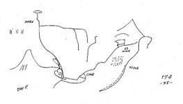
Lost Dutchman gold mine legend

The portion of the Superstition Mountains situated at the west end of the Superstition Wilderness has long been considered the most likely location of the legendary Lost Dutchman Gold Mine (Blair, 1975).

Weaver's Needle in the NWI/4 sec. 18, T. I N., R. I0 E. is often thought to be one of the key landmarks for finding the lost mine.
Jacob Waltz, the Dutchman of the legend, died in Phoenix in 1891. Since then, treasure hunters in search for the lost mine have dug hundreds of holes in sight of Weaver's Needle.

The sites of many of the pits, gopher holes, shafts, and tunnels were selected on the basis of lost-treasure maps or psychic phenomena. Bureau of Mines personnel sampled and mapped some of the lost treasure diggings during the present survey.

Most workings are in unconsolidated, nonstratified surface material or show no evidence of alteration, mineralization, or other geologic indication of mineral deposition. But despite these odds, people continue to search for the Lost Dutchman Gold Mine and other legendary lost mines and treasures within the Superstition Mountains.

Excerpt from pages 7 & 8 (from pdf)

Mining history and production

According to J. B. Tenney (Wilson and others, 1967), Spanish and Mexican miners in Arizona, prior to the acquisition of the territory by the United States, mined a little silver but no appreciable gold. Tenney comments that, except for some prospecting and mining near Tubac and Tucson prior to the Civil War and some prospecting and mining of rich gold placers in the central part of the state during the Civil War, little prospecting and mining were done in Arizona before the establishment of peace with the Indians about 1872.

The silver deposits of Silver King, Globe, and Superior, east and south of the Superstition study area, were discovered about 1874; presumably, the Superstition study area was prospected at the same time or shortly thereafter.

The Goldfield Mine, about 2 ml west of the study area (pl. I), is reported to have been worked during the early 1890's (Wilson and others1967). At about the same time, initial work at the Palmer Mine. Located inside the proposed western addition to the Superstition Wilderness, was begun. The Palmer Mine has produced gold. The asbestos and iron prospects outside the southeast boundary of the Wilderness have no recorded production.

The adits in upper Rogers Canyon and the workings in upper Whetrock Canyon may have produced silver but there is no official record of such production. During the time of the field investigations, there were no producing mines within the Superstition Wilderness or the proposed additions.

Mining claims and mineral leases

Bureau of Mines personnel searched Federal public land records and county courthouse records for information on mining claims and mineral leases within the Superstition study area in 1973. Public land records of the U.S. Bureau of Land Management at the Arizona State Office in Phoenix showed no patented mining claims and no mineral leases, past or present, within the study area. Notices of location of mining claims and affidavits of annual labor on file at the Pinal County Courthouse in Florence and the Marlcopa County Courthouse in Phoenix indicate continuing low-level mineral activity in the study area. A search of the mining records of Gila County at Globe revealed few notices of location for claims in or adjacent to the study area. Most of the mining claims filed over the years have not been maintained by the filing of affidavits of annual labor or assessment work. Some of the mining claim notices refer to lost mines or lost treasures, and many more notices have names which suggest that the claimant was primarily interested in legendary mines. Scattered older mining claims in and near the southeast corner of the Wilderness were staked on showings of asbestos and iron. Blocks of mining claims held by major mining companies near the Superstition Wilderness include claims connected with the Pinto Valley Mine east of the Wilderness and claims connected with porphyry copper exploration southeast of the Wilderness between Miami and Superior. The boundaries of the blocks of mining claims extend roughly along the west side of Pinto Creek Valley and along Haunted Canyon.

http://www.mines.az.gov/DigitalLibrary/USBM_MLA/USBM_MLA_136-82.pdf

If we look at the area in question realistically we would not find any group of Mexicans (Peraltas, Gonzales) looking/prospecting for gold in known Apache lands until the Apache were crushed. The Apache hated the Mexicans and would take any opportunity to wipe them out, especially when they entered their lands so boldly, without fear. You never poke a stick into the eye of an Apache and get away with it. I have had numerous Apache friends throughout the years and know quite well what can happen once you are standing upon their lands and you are the only white man that can be found for many miles.

The other problem that exists is related to the Superstitions themselves. Ask any normal Catholic raised Hispanic person to accompany you into the Soups for a couple days, no Apache to worry about, we have plenty of food and water, etc. After maybe one day, two at the most they will run from the area filled with fear due to the fact of their superstitious nature. How do you think the Superstition Mountains earned the name? I have access to an excellent Yaqui/Mexican/Catholic raised guide who respects (fears) the Soups and will to this day swear that the infamous Jesuit known as the “Black Robe” is alive and well, and in fact grabbed his foot and tried to pull him out of his tent. He is still literally “frightened to death” even to this day. Sal was raised by his mother and father and was taught the legends of the “Black Robes” and he believes the stories based on the knowledge of his tribe, the Yaqui. You did not cross these warriors either. Sal believes in the Jesuit Mines and treasures, just as I do. The Peralta legends? Not for a minute.


Later,

Ellie Baba
 

Twisted Fork

Hero Member
Sep 2, 2007
723
52
UTAH
Detector(s) used
tf900 & a good old fashioned willow forked limb
The King of Spain went insane with lust and the entire Jesuit Empire went where it will. 1760-70's. They all were scared to death of the Jesuits who were an increasing threat to queer sorts of royalty everywhere. Everyone was after their treasures and still are to this day. In this time span with early warning and threat of execution, the monks retaliated and went about hiding the gold trail from the oncoming Franciscans. A code within a code within a code. Go figure.

Monks were found to be numbered amongst the last years of piracy in the gulf as they took back treasure headed for Spain and hid it back in the hills far out of reach of the Franciscans. Peralta blood was thick on the trail and it is know that their cattle ranches were funded by gold mines that were handed down to them over the years.

There is far more evidence to prove the mines and their handlers existed than meets the eye. If you spent anytime in their neighborhood, you would know this and so would the pencil pushing geeks that did those studies in the first place.

Gold found in the Supers, on the bodies of various victims came from the salted trail left behind by the Peraltas, who made much more of a game of it than the Jesuits. As a man has his own unique hand writing style, "his English per say" so did each Don in the manners of which they marked and built on the Jesuit trail started and left behind for the Peraltas to pick up on.

The term "English" also applies to the game of "Billiards" wherein a fellow puts a spin on it. Get it? I doubt it. Get on the trail and see for yourself or stuff it pal. If you want to truly experience a pack of dimwits, just visit any institution of learning these days. These highly intelligent and educated Mason gentlemen, left behind sign; sign according to an ancient creed. Sign is picture shapes and art speaks a thousand words to say the least. Peralto picture maps of both stone and paper have survived the onslaught of dimwits everywhere and the dates, stones and the very gold mines which have been found by myself and other close associates, more than back up their entire story in fine detail. Their signatures are pounded in stone everywhere.
 

Blindbowman

Bronze Member
Aug 15, 2007
2,042
978
Primary Interest:
All Treasure Hunting
TF .. i think your post was very close ... the fact is the Jesuits were a very disciplined order yet 98% were "black robes " on the other hand was the leaders of the Jesuit and they made the earth spin as we know it .. nothing moved with out their knowing it ,and they could direct and control the flow of product very easily.. when the tayopa massacre took place these were the victims of the massacre .. this had never happened before that massacre ..they had taken the time to create these coded items ,, they just never believed the massacre was a real possibility..

your not look at a every day turn of events ,, this high Jesuit have most likely never been seen and very little was ever known about them .. other then the dressing in the window like Kino.. most were never seen or even knew were a reality ..

here is something you may find interesting .. this is higher Jesuit that made the stone yet he is a Spanish Portuguese and educated in vulgar Latin most likely in northern Italy , this is not your pick of the month Jesuit priest .he most likely in the top 5 of the total Jesuit order ,, this make good logic .. the massacre cut the head off the snake .. basically .. with out the leadership to control what happened to the mines and the coded date , it ended up in the basement of the church, with few people left in the order to solve the best code they ever had .. just like you said most were geeks and had no real training in this type of complex code and translation skills ..

i have this code broke all the way down .. i know where the treasure is and why its there .. if you think the dead fall Waltz made was dangerous wait you have not seen anything yet ..

yes the stone are real...this is a rare find .. these are items the world would have never got to see at all..

it took a massacre of the higher Jesuit for us to see them here today .. there maybe 1 or 2 people in the last 460 years that could decode these items .. and when the translation is made public .. i can not describe what a beautiful master piece we see before us in these items .even i would have to bow out of respect for someone of this skill level ....you are looking at a equal to the true Mona Lisa ...

i have a mechanical aptitude of 223 on a scale of 1 to 100 i tested 107, i am a documented genius and this person has keep me working and researching for 9 years to brake this code

,i am a hard person to impress .. this Jesuit is one of the best minds i have ever seen in the history of the human race . he is that good ...

i would add that he was most likely killed at the Tayopa massacre ...i don't think there was any way the Jesuit order could recover from a loss of this scale ...not in 400 years or more
 

Twisted Fork

Hero Member
Sep 2, 2007
723
52
UTAH
Detector(s) used
tf900 & a good old fashioned willow forked limb
Good enough to fool the Dominguez Expedition. It would appear that their famous map maker Meira was in on it with the Black Robes on the side. Here is another example of things appearing to be something they are not. The expedition was a fake fanfare splashed about with the natives and their world used as a distraction. Dominguez was on a secret mission assigned in the effort to figure out just what happened to all of the treasures that the Jesuit had recently concealed across the West. Miera had a mission all his own. May these examples provide the real story in sign. Shadows of the past, bring to life the natures of the beast.
 

Attachments

  • MieraMasterMap.jpg
    MieraMasterMap.jpg
    147.4 KB · Views: 708
  • MasterMapInsert.jpg
    MasterMapInsert.jpg
    100.5 KB · Views: 733

Blindbowman

Bronze Member
Aug 15, 2007
2,042
978
Primary Interest:
All Treasure Hunting
good question i dont know about that ..

i have located and pinpointed 35 locations useing the stone to 1 cubic ft ..

i have bee able to define the location of the +-/= stone marker .. i dont know what we will find there but i could use some feet on the ground at the renedenzous i asume it is some kind of marker stone . a fix point for DR tracking , it has to be a real oject or marking that a person can get a clear navigation fix from ..
 

Twisted Fork

Hero Member
Sep 2, 2007
723
52
UTAH
Detector(s) used
tf900 & a good old fashioned willow forked limb
You appear to have serious conformation before you. Enclosed is an E-Mail address. This is a very busy man with interests that may hook you up. Very serious inquiries only, please.

Stephen Shaffer <[email protected]>;

He is a special kind of individual who lives here in Utah.
 

Blindbowman

Bronze Member
Aug 15, 2007
2,042
978
Primary Interest:
All Treasure Hunting
Twisted Fork said:
You appear to have serious conformation before you. Enclosed is an E-Mail address. This is a very busy man with interests that may hook you up. Very serious inquiries only, please.

Stephen Shaffer <[email protected]>;

He is a special kind of individual who lives here in Utah.

i don't know if that sounds like a good idea or not , Freddy crystal went to Utah and never left ..thank you are the offer .. ya never know ..

i can fully read the stones now and the big hole in the bottom stone dose show up on google earth but its hard to get to and step .. i don't know how they got up there ???
 

Twisted Fork

Hero Member
Sep 2, 2007
723
52
UTAH
Detector(s) used
tf900 & a good old fashioned willow forked limb
Doodle happens; ya got that right. Their doing treasure film work now and are looking for notable characters last I heard. Utah has it's share of ghosts.
 

Twisted Fork

Hero Member
Sep 2, 2007
723
52
UTAH
Detector(s) used
tf900 & a good old fashioned willow forked limb
Some of the richest mines are near suicide to get to; little or no way to get an animal near. Then to save you the trouble, they booby-trap them. Little wonder why some of their spirits are still wandering around the mine; monks too!
 

OP
OP
gollum

gollum

Gold Member
Jan 2, 2006
6,729
7,598
Arizona Vagrant
Detector(s) used
Minelab SD2200D (Modded)/ Whites GMT 24k / Fisher FX-3 / Fisher Gold Bug II / Fisher Gemini / Schiebel MIMID / Falcon MD-20
Primary Interest:
All Treasure Hunting
Ray Grant at the Arizona Mining and Minerals Museum just sent me an email containing the accession document showing the basic circumstances of how the museum obtained the Stone Maps.

Notice how Clarence Mitchell's name is nowhere to be seen. The donation is from the STOCKHOLDERS of MOEL Inc, By: Boyd Cochrane.

Enjoy-Mike
 

Attachments

  • stoneMapsAccession.jpg
    stoneMapsAccession.jpg
    87.6 KB · Views: 558

cactusjumper

Gold Member
Dec 10, 2005
7,754
5,389
Arizona
Mike,

I'm not sure why you think it's important that Mitchell's name is absent from that document.

My take on what happened, is that Mitchell knew the Stone Maps had no substantial value. On the other hand, MOEL stock could be sold for cash. Easy answer......Sell the company the Stones for MOEL shares, sell the shares, and get out of Dodge.

The only thing that points to MOEL having to "donate", by court order, the Stone Maps, is rumor. There is, as far as I know, not a single scrap of documentation that even hints that anything like that took place. Everything concerning the authenticity of the Stone Maps, that is documented, is negative. Everything else is what someone heard or claims they saw.

You've been looking, hard, for awhile now. What's the most solid piece of evidence you have found?

Take care,

Joe
 

Blindbowman

Bronze Member
Aug 15, 2007
2,042
978
Primary Interest:
All Treasure Hunting
CJ : do you know or know of a man named Geo Koethler,,i am now going back and tieing up lose ends ,, i just got a copy of Els's book dated 1964 and its singed Geo Koethler and has some hand writen notes in the back ,,very interesting notes ....? its dated 5/2/66 and signed ,

i have no idea if the notes are his or someone else's....the focus of the notes was in your search area....near where ruth's body was found ...
 

Javaone

Full Member
Aug 9, 2010
192
4
Phoenix
I have heard rumors that there is a fifth stone that is connected to the "Peralta Stones" - called the "Indian Face" stone.
Anyone have any info on that? :help:
 

Top Member Reactions

Users who are viewing this thread

Top