What's new

Two Soldiers Lost Mine -- The Waterfall and the Route

skyhawk1251

Sr. Member
🥇 Charter Member
Joined
Nov 9, 2018
Messages
442
Reaction score
1,148
Golden Thread
0
Location
Kingman, AZ
Detector(s) used
Fisher Gold Bug Pro
Primary Interest:
Prospecting
The story of the "Two Soldiers Lost Mine" is associated with the LDM, due to the fact that the mine described by the two soldiers matches the mine as told by Jacob Waltz. Whether the two sources are mostly factual or mostly fiction is open to conjecture, but we have to do the best with what we have to work with.

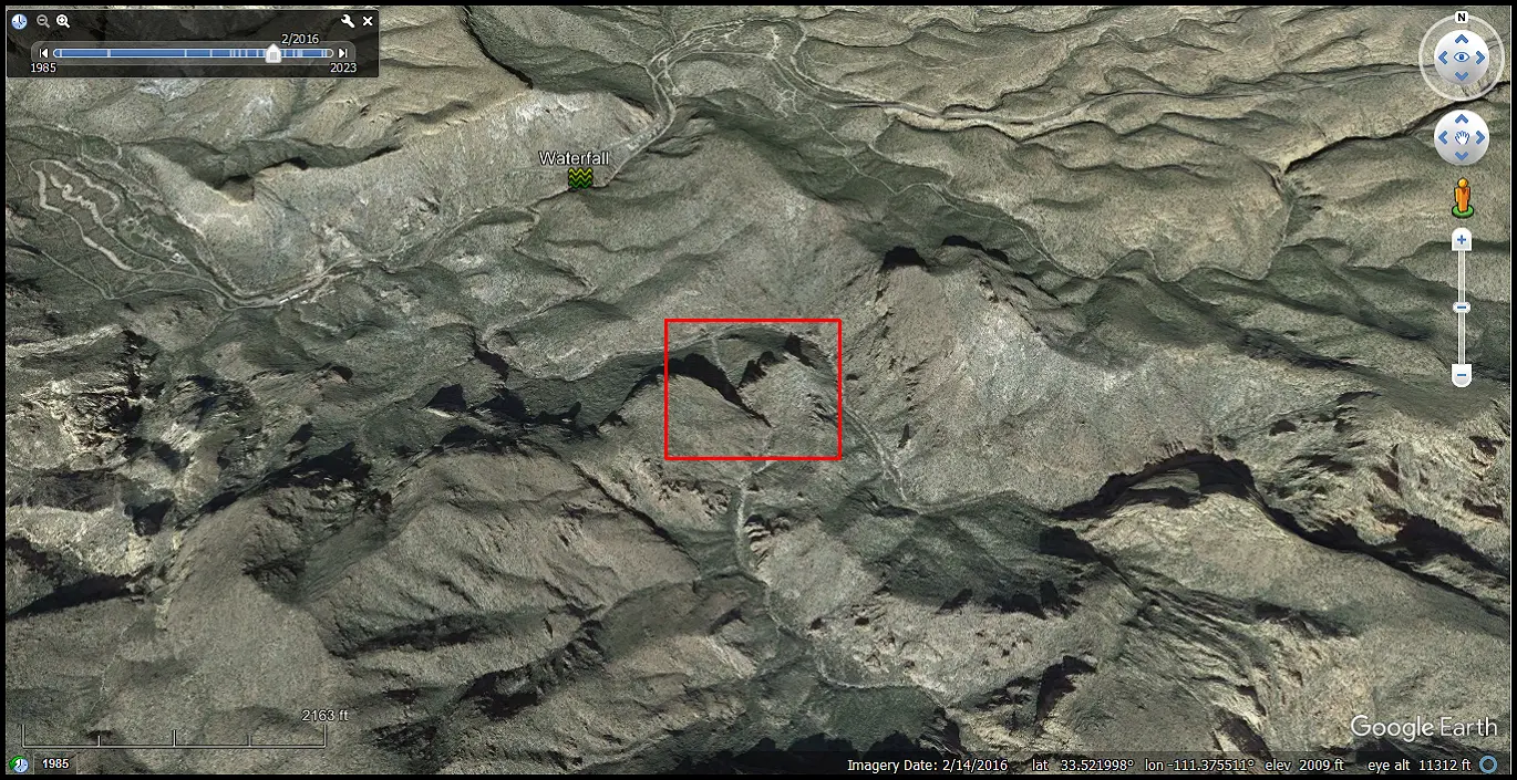
Bark's Notes hints at what could have been the starting point of the two soldiers' route to the mine. In the Google Earth image below, I've marked the place where I see a waterfall on Tortilla Creek. There is a constriction in the creek bed at that point and an elevation difference of about 48 feet above and below the constriction. I haven't hiked Tortilla Creek, so I can't say if what Google Earth is showing me is accurate. The GPS coordinates of the waterfall are at the bottom of the image.

I'll continue this thread later with some thoughts on what Tom Kollenborn's map shows as "the trick in the trail" and what I see as part of the soldiers' route to the mine.
... they struck out toward the King, crossed the Salt river, and struck a trail which they had been told was the proper one to take, and which is now called the Apache Trail, but it is now an automobile road. They followed it for several miles to a creek crossing, where there was water. The trail after that appeared to run nearly north, and the King was nearly south, so while they felt certain that the trail would eventually land them at the King it must be a long way around and they were tired. They decided to make a short cut, went up this creek for some distance, came to a waterfall and could go no further." -- Bark's Notes

TS01.webp
 
The story of the "Two Soldiers Lost Mine" is associated with the LDM, due to the fact that the mine described by the two soldiers matches the mine as told by Jacob Waltz. Whether the two sources are mostly factual or mostly fiction is open to conjecture, but we have to do the best with what we have to work with.

Bark's Notes hints at what could have been the starting point of the two soldiers' route to the mine. In the Google Earth image below, I've marked the place where I see a waterfall on Tortilla Creek. There is a constriction in the creek bed at that point and an elevation difference of about 48 feet above and below the constriction. I haven't hiked Tortilla Creek, so I can't say if what Google Earth is showing me is accurate. The GPS coordinates of the waterfall are at the bottom of the image.

I'll continue this thread later with some thoughts on what Tom Kollenborn's map shows as "the trick in the trail" and what I see as part of the soldiers' route to the mine.


View attachment 2216922
Skyhawk1251

I agree with you, that the 'Two Soldiers' story and the LDM have similar clues - as during my research, I found that paths mentioned seem to cross over each other in similar places within the Supes. I also believe the Dr. Throne story too, might have a similar connection - not to forget the Jenkins' cache or the lost Mine (if you believe that part has any truth to it). All four stories always puts my research in the same vicinity of each other and it's NOT in the Northern part of the Wilderness.

-SpartanOC
 
SpartanOC,

Jenkins' Lost Lode is the place where J. Clapp's mine is located, just west of Hackberry Mesa. That location doesn't correspond with anything written about the Two Soldiers Lost Mine or the LDM. The spot where a body was found, supposedly one of the soldiers, is something very important to consider. I'll get onto that topic later.
 
PART TWO --

Tom Kollenborn drew a map showing a "monumented trail" that seems to lead onto Geronimo Head. It might be tempting to associate this map with the route to the Two Soldiers Lost Mine, but Tom Kollenborn himself had the two soldiers hiking along Tortilla Creek to Randolph Canyon, then to Fraser Canyon. He made no mention of Geronimo Head when writing about the Two Soldiers Lost Mine.

I can follow the Kollenborn map through his "trick in the trail", then onwards to where a pass is indicated about midway along his monumented trail. Google Earth shows no evidence of any trails on Geronimo Head, and certainly can't show any trace of rock cairns (monuments). If there was any monumented trail, the map seems to indicate that it deadended somewhere on the cliffs overlooking Labarge Canyon.

I believe the two soldiers were committed to following Peters Canyon southeastward. Once they entered the canyon there was no way out. They had to keep going onward. It is very rough country, and they probably wondered if they would live to complete their journey. One thing could have been in their favor, however. There undoubtedly was abundant water in the canyon.

I'll continue this thread with thoughts on where the two soldiers might have gone after they found their way out of the roughest parts of Peters Canyon.

... came to a waterfall and could go no further. They came back down the creek, and finally got out on the side of the creek toward the King, and up on a very rough and high mountain. There was no trail. They struck out, always trying to work toward their destination, but making very slow progress. They ran on to a trail, and such a queer place for a trail. They concluded to follow it and see if it wouldn't lead them out of that God-forsaken country. They followed it but a short distance and were in high hopes when the trail led them through a cave between the peaks. It must have been a foot trail, as animals could not go through the cave. They went on a little further, and came to a tunnel that had been walled up, with working above and over. They said that they did not believe that what they saw was gold, as there was so much of it. -- Bark's Notes


They remembered that it was in a northerly direction from a sharp peak, which they had seen in their scouting days. Mason at once identified this in his own mind as Weaver's Needle.

The boys explained that in their soldiering through strange, rough country, they had been taught by their officers to do as the Indians did, that is, to look back along the trail from time to time so as to see what the landmarks looked like from the opposite direction. This they had done. Moreover, on their way out, they had struck a trail which led them through a little gap in the range not far from the peak, and this trail was very old, leading them into a valley perhaps two miles wide. This valley ran easterly and westerly, and they had followed the easterly portion until they crossed some canyons - still in the direction in which they knew they must go - and passed a horse ranch where there were corrals. From that ranch there was a trail into Pinal.

It had been understood between the boys and Mason that, counting on a distance not to exceed twenty-five miles from Pinal to the mine, the journey could be made with burros quite easily in two days going and two days returning.

... it occurred to Mason that he might have made a mistake in assuming that Weaver's Needle was the peak the boys had mentioned as their landmark. Any one of several other pinnacles could have been the right peak he now reasoned -Tortilla Mountain, for example, which is much higher than Weaver's Needle and is the more conspicuous landmark of the two from some directions. -- Sims Ely

KM01.webp


KM02.webp


TS01.webp


TS02.webp


TS03.webp
 
The Google Earth image below will put things into perspective as to where I think the two soldiers began their trek and where they wanted to go (Silver King Mine). I think that once the two soldiers had cleared Peters Canyon they found themselves on Peters Mesa. From there, they could have made their way farther eastward where they could have found themselves on the Old Spanish Trail that runs east of Music Mountain and passes by Horse Camp Basin. They exited the mountains by descending past Miners Needle.

Those who are familiar with navigating in canyons and mountains know that going by compass headings alone aren't enough. Navigating by using prominent landmarks along the way is also very necessary. The two soldiers didn't have an accurate map or GPS to guide them, so they had to rely heavily on landmarks as they went.

A.webp
 
The story of the "Two Soldiers' Lost Mine", one of several connected to the Lost Dutchman's Gold Mine in the Superstition Mountains of Arizona. The alleged story says two soldiers, after being mustered out of Fort McDowell in 1879, found a rich vein of gold in the mountains. They supposedly hid their cache of gold before one soldier died, and the other never returned to retrieve it What would be good or at least help identify the names of the two soldiers of the alleged story.

In 1879, Fort McDowell, previously known as Camp Verde, was officially designated as a fort and renamed in honor of General Irvin McDowell. The fort was established to protect settlers and travelers from Apache raids in the Gila and Salt River Valleys. Muster records from this period would likely be held by the National Archives and Records Administration and could be requested through their online portal, by mail, or in person.

NARA is the primary repository for military service records. You can search their online catalog or contact them directly to inquire about the 1879 muster records for Fort McDowell. Some genealogical websites and databases may have digitized versions of military records. You could explore these resources, but be aware that access and accuracy may vary. When requesting records, you'll need to provide as much information as possible, such as the soldier's name, rank, unit (if known), and approximate dates of service.

In addition to NARA, some state and local archives may hold relevant records, particularly if the soldiers were from a specific region.
Organizations specializing in military history may have information or resources related to Fort McDowell and its muster records.

If I have two names to work with I could help you.

There has been several dates given in regards to this soldiers story. one is 1879 and 1883.


The Two soldiers story.


I have been going through Fort Mc Dowells records. I suspect if the story is true it was earlier.

The Silver King Mine, located near Superior, Arizona, was once the richest silver mine in Arizona. It produced an estimated US$42 million worth of silver ore between 1875 and 1900. The mine also yielded smaller amounts of gold, copper, zinc, and lead. The Silver King deposit was discovered in 1872 by soldier Sullivan while building a road. He found silver sulfide nuggets and later shared the information with rancher Charles Mason. Mason and a group of prospectors confirmed the discovery in 1875, marking the start of the mine and the Pioneer Mining District.

The Silver King Mine was located three miles north of Superior, in Pinal County, Arizona. The early mining camp was isolated, with limited infrastructure, including two hotels and saloons. The mine was later connected to other mining areas through a road known as the Stoneman Grade The mine was known for its high-grade silver ore. A 20-stamp mill, later expanded to 40-stamp, along with a roaster and concentration works, were established to process the ore. The mine operated intermittently until 1920, with a brief period of production at the end of World War I The Silver King Mine was a major catalyst for mining activity in the region during the 1870s and 1880s. It helped to develop the towns of Pinal City and Superior. The mine is estimated to have yielded approximately 6.2 million ounces of silver.

I suspect if the story true the two story solider was from 1874? 304 soldiers in the records. There was no returns after 1874. In theory we could trace through the names many would have death records to dismiss those who have recorded burial site and death records. If there was a few than have no record they might of been one of two men?

that in itself would be amazing discovery.

here is example blow of returns.

Screenshot 2025-07-17 223127.webp


Crow
 
SpartanOC,

Jenkins' Lost Lode is the place where J. Clapp's mine is located, just west of Hackberry Mesa. That location doesn't correspond with anything written about the Two Soldiers Lost Mine or the LDM. The spot where a body was found, supposedly one of the soldiers, is something very important to consider. I'll get onto that topic later.

Skyhawk1251

My theory is, that the Jenkin's lost Mine is further East of Hackberry Mesa - located in the area South of Garden Valley. It is just a theory - but in some of my research it came to me, that the Jenkins family used Apache Trail to head into the Wilderness - from Canyon Lake area, or so according to the story and it made sense that the Family traveled South Southeast to a flat area to have their picnic. I wouldn't think they went in that far - but the story has the family going in as far as an hour or so - then settling in for the day. Then Jenkins himself went out for a walk, stumbling onto the loose load - which was probably near a Mine.

With that story in mind and the research I've done with the LDM - I find myself in similar areas. I have not found any link - that would tie in the Lost Soldier's mine (load) to the Jenkins, but noting that the Lost Soldiers came out of Fort McDowell and the Jenkins family came from a similar direction (from the North end - which the Soldiers could have come through as well heading in a similar direction), has my attention. As for the LDM, no connection when it comes to clues, but WHERE I believe the LDM is possibly located, seems to cross over similar areas when I study the Jenkins and the Lost Soldiers tales. I can't go into any more details regarding the LDM, as that investigation is still ongoing and an expedition is needed to validate some theories.

I am though, curious as to the location of said body that was found with regards to the Lost Soldiers legend. Any ideas of that location?

-SpartanOC
 

Users who are viewing this thread

Latest Discussions

Back
Top Bottom











