sgtfda
Silver Member
Travis used a X/O substitution code on the stone maps.


They're out in full force these days....Did you see that rattler?

We broke an axle on the jeep going up past the hair pin one time.Advice if you are planning a visit to Rodgers trail head . The last leg of the road is a short uphill run. It loves to eat tires. Off road tires are best. I told RG that and he drove up there with street tires. The result was 4 flats and a $800 tow bill. I don't advise driving off that mountain after dark unless you have off road lighting! Two vehicles at least is best. Stuff happens. I have a built TJ for spots like that.View attachment 2255224

Howdy Frank,Travis used a X/O substitution code on the stone maps.View attachment 2254972
This helps prevent that.We broke an axle on the jeep going up past the hair pin one time.
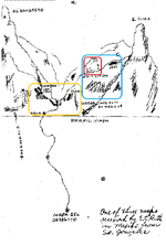
I think you know I agree with you that the aforementioned spire is S. SIMA. Did you measure from Weavers Needle? 15,000 meters. I know you're not a fan of my book, so I'm not expecting any positive acknowledgement from you.. but now take the next logical step to solve the map.The cliff dwellings in Rogers Canyon are well known today, and were probably just as well known in P.C. Bicknell's time. They, and the Perfil Mapa (Profile Map), could explain why he was drawn to that area during his search for the Lost Dutchman Mine.
Despite Bicknell's failure to find the mine, as well as the lack of success by other searchers, I think it is unwise to totally dismiss Rogers Canyon as the possible site of a mine. From what I see, just from using Google Earth, there is sufficient evidence to justify some intensive exploratory trips to the canyon.
Unlike some others who have deduced that the Perfil Mapa was drawn by a person who stood in one place and drew what he saw by looking from side to side, I see the map as picturing surface features in profile that are seen as a person walks along the canyon and encounters them one by one. I came to that conclusion when I noticed a prominent, rock pinnacle that matches the shape of what is depicted on the map, and associating it with the cliff dwellings -- two features on the map that are in different locations in the canyon. With those two features in mind, it was possible to include other features that could agree with the scheme of the map.
It's important to mention that there are apparent spelling errors on the map. "Sima" should be "cima" and "escardadia" should be "escarpadia."
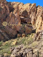
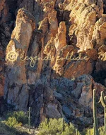
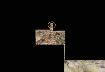
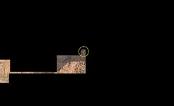
There should be no doubt about "caverna con casa" -- the cliff dwellings. My Google Earth 3D image below shows the "cima" -- the rock pinnacle. There is a rock formation that could be "escarpadia", shown in another GE image. Rogers Canyon Spring is easily found using Google Earth -- "agua" on the map. If "tunel" and "hoya" exist, they will not be seen using Google Earth, which is why on-the-ground exploration is justified.
Going from south to north, the following features are passed: Rogers Canyon Spring, cima, escarpadia, caverna con casa.
Google Earth also seems to show a "pit" about 35 feet in length in the canyon (the third image). See the GPS coordinates for its location.
View attachment 2254317
View attachment 2254318
View attachment 2254319
View attachment 2254320


Great insight, however i would respectfully disagree based on the consistent sizing and spacing of the letters, and i really dont see the "N" at all. I I think your C is a map marking, similar to the hidden valley lines that cross.Hi Geoff,
It looks to me like the wording is "Monte de la Coronado", which sounds like they were trying to say "crowned mountain" or something like that.
View attachment 2260432
I like your book!I think you know I agree with you that the aforementioned spire is S. SIMA. Did you measure from Weavers Needle? 15,000 meters. I know you're not a fan of my book, so I'm not expecting any positive acknowledgement from you.. but now take the next logical step to solve the map.
Sorry, perhaps I replied to the wrong message, but I was responding to Skyhawk1251's post. He was quite critical of my book and of several of my conclusions in a posted review. When I saw that he also believes that particular spire is S Sima, which is something I specifically identified in the book, I wanted to encourage him to take that observation a little further.I like your book!

Many have and many still wonder what the word " ESCARDADIA " written below the profile would means. That word means how " after you will clean/resolve all the clues till the end of the day, and you have found the "HOYO ", looking to the south you will see over the point of a low ridge, that shape made by many boulders that prompts to a human face profile. This landmark could be seen only from the mine location and not from another spot on the way.I doubt Perfil Mapa is related to the Rogers or Peters canyons. IMHO, this map is one if not the most complicated coded treasure map ever made. I believe Gonzales put all his talent down in regards to make this map, which without his oral or written instructions on how to interpret it, only someone who knows for what region was made and using his imagination and skills, would be able to understand it.
IMO, in that map are depicted four different images, with only one which should be reversed. The other three should be seen as they are depicted on the map, but for one of them should be reversed only the orientation in the field and not as an image. Also the words " sierra mas alta en medio de ", have three different meanings in regards with two different images which should not be reversed.
Now, a detail that could make the difference in this map, is how in a 3D depicted map which should be reversed, the image is not mirrored like in a 2D map, but all the landmarks in the image should be reversed as you are seen them from the other side of the image. So, what landmark is in the first image close to you and to the left, after reversing it, the same landmark will be afar to the right and beyond the other landmarks which was in its background before reversing.
I will post a copy of the original Perfil Mapa, with the images which are in the colored frames to be those which should be not reversed.