- Joined
- Nov 9, 2018
- Messages
- 443
- Reaction score
- 1,169
- Golden Thread
- 0
- Location
- Kingman, AZ
- Detector(s) used
- Fisher Gold Bug Pro
- Primary Interest:
- Prospecting
- #1
Thread Owner
The cliff dwellings in Rogers Canyon are well known today, and were probably just as well known in P.C. Bicknell's time. They, and the Perfil Mapa (Profile Map), could explain why he was drawn to that area during his search for the Lost Dutchman Mine.
Despite Bicknell's failure to find the mine, as well as the lack of success by other searchers, I think it is unwise to totally dismiss Rogers Canyon as the possible site of a mine. From what I see, just from using Google Earth, there is sufficient evidence to justify some intensive exploratory trips to the canyon.
Unlike some others who have deduced that the Perfil Mapa was drawn by a person who stood in one place and drew what he saw by looking from side to side, I see the map as picturing surface features in profile that are seen as a person walks along the canyon and encounters them one by one. I came to that conclusion when I noticed a prominent, rock pinnacle that matches the shape of what is depicted on the map, and associating it with the cliff dwellings -- two features on the map that are in different locations in the canyon. With those two features in mind, it was possible to include other features that could agree with the scheme of the map.
It's important to mention that there are apparent spelling errors on the map. "Sima" should be "cima" and "escardadia" should be "escarpadia."
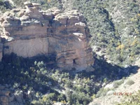
There should be no doubt about "caverna con casa" -- the cliff dwellings. My Google Earth 3D image below shows the "cima" -- the rock pinnacle. There is a rock formation that could be "escarpadia", shown in another GE image. Rogers Canyon Spring is easily found using Google Earth -- "agua" on the map. If "tunel" and "hoya" exist, they will not be seen using Google Earth, which is why on-the-ground exploration is justified.
Going from south to north, the following features are passed: Rogers Canyon Spring, cima, escarpadia, caverna con casa.
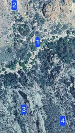
Google Earth also seems to show a "pit" about 35 feet in length in the canyon (the third image). See the GPS coordinates for its location.


Despite Bicknell's failure to find the mine, as well as the lack of success by other searchers, I think it is unwise to totally dismiss Rogers Canyon as the possible site of a mine. From what I see, just from using Google Earth, there is sufficient evidence to justify some intensive exploratory trips to the canyon.
Unlike some others who have deduced that the Perfil Mapa was drawn by a person who stood in one place and drew what he saw by looking from side to side, I see the map as picturing surface features in profile that are seen as a person walks along the canyon and encounters them one by one. I came to that conclusion when I noticed a prominent, rock pinnacle that matches the shape of what is depicted on the map, and associating it with the cliff dwellings -- two features on the map that are in different locations in the canyon. With those two features in mind, it was possible to include other features that could agree with the scheme of the map.
It's important to mention that there are apparent spelling errors on the map. "Sima" should be "cima" and "escardadia" should be "escarpadia."
There should be no doubt about "caverna con casa" -- the cliff dwellings. My Google Earth 3D image below shows the "cima" -- the rock pinnacle. There is a rock formation that could be "escarpadia", shown in another GE image. Rogers Canyon Spring is easily found using Google Earth -- "agua" on the map. If "tunel" and "hoya" exist, they will not be seen using Google Earth, which is why on-the-ground exploration is justified.
Going from south to north, the following features are passed: Rogers Canyon Spring, cima, escarpadia, caverna con casa.
Google Earth also seems to show a "pit" about 35 feet in length in the canyon (the third image). See the GPS coordinates for its location.