What's new

Perfil Mapa and Rogers Canyon

And, the word " HOYO " written in the Perfil mapa it's not for a mine, but for a land depression or otherwise a gap in the ridge line. In that land depression is located the Peraltas inclined shaft known from the John Reed's description. Someone would say that depression looks like a saddle, but no, not that from the Holmes route. That is bigger and higher.
 
And, the word " HOYO " written in the Perfil mapa it's not for a mine, but for a land depression or otherwise a gap in the ridge line. In that land depression is located the Peraltas inclined shaft known from the John Reed's description. Someone would say that depression looks like a saddle, but no, not that from the Holmes route. That is bigger and higher.
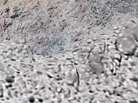
Could this be the hoyo?
 

Attachments

  • IMG_0838.webp
    IMG_0838.webp
    318.4 KB · Views: 31
Could this be the hoyo?
No, from what I was told. The HOYO is on the apex of an elongated hill which is located between two tributary canyons that belong to the same mountain body.
Go by the Erwin Ruth clue on the LDM. He got it directly from Gonzales mouth. The only word I would correct in that clue is the word "on" when is referring to the mine's location, with the word "higher" or "above" as an altitude reference in regards to the landmark described. Sometimes the word "on" could means how something belongs to the same body, but in this case Gonzales wanted to say how the mine it's in the back side of that landmark as seen from below.
 
No, from what I was told. The HOYO is on the apex of an elongated hill which is located between two tributary canyons that belong to the same mountain body.
Go by the Erwin Ruth clue on the LDM. He got it directly from Gonzales mouth. The only word I would correct in that clue is the word "on" when is referring to the mine's location, with the word "higher" or "above" as an altitude reference in regards to the landmark described. Sometimes the word "on" could means how something belongs to the same body, but in this case Gonzales wanted to say how the mine it's in the back side of that landmark as seen from below.
Well for me probably being the only guy on here that was actually there, I think it is. I met my limitations trying to take a short cut up past that to get on the top of White Mnt. I searched all around up there to find a safe pathway but to no avail. When I was coming back down I got cooked by the sun pretty bad and my legs were wobbly so I figured to camp for the night right by the pool then high tail it out in the morning and save it for next time.
 
Well for me probably being the only guy on here that was actually there, I think it is. I met my limitations trying to take a short cut up past that to get on the top of White Mnt. I searched all around up there to find a safe pathway but to no avail. When I was coming back down I got cooked by the sun pretty bad and my legs were wobbly so I figured to camp for the night right by the pool then high tail it out in the morning and save it for next time.
Then, what I have to say is good luck. From what I know, the hoyo looks like this, prim plan in the GE image
 

Attachments

  • HOYO.webp
    HOYO.webp
    148.3 KB · Views: 34
Could you explain this furt
If you will read the Erwin Ruth clue, you will understand. It's not on but just beyond that landmark looking from below. Maybe a meaning lost in the translation. If Gonzales was speaking English like Salvador Delgadillo or worse, then imagine the result.
 
Last edited:
Then, what I have to say is good luck. From what I know, the hoyo looks like this, prim plan in the GE image .

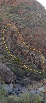
This is what the Tunnel looks like on the perfil map, its blocked and hidden behind the shrub in middle of pic. Can see a little bit of it. Can see the Carim above it and a little to the left to mark the spot.
IMG_20241122_131256487.webp
 
Last edited:
You could post Google Earth images (close-ups) of those five spots, leaving out the GPS coordinates at the bottom of the images, as well as compass direction and size scale. Nor would you have to describe what you see in the images. Let others decide what they see, if anything.
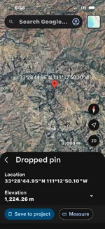
Here is 1 spot. Gold runs on an iron horse. This is is where I stayed when I went to see el hoyo and took photo of where the tunnel was. This Wasn't even on my radar. Found it recently going through my photos.. feel dumb for not climbing around that way, but wasn't what the trip was about at that time. Mineralized in that area.. I think so. But also why el hoyo isn't the ldm... Ldm is a lil further way if ya believe in the waybill waltz had forr the mine.
 

Attachments

  • Screenshot_20261009-181334.Messenger.webp
    Screenshot_20261009-181334.Messenger.webp
    301.7 KB · Views: 9

Users who are viewing this thread

Back
Top Bottom