Very strange tree arrangement. Anyone want to take a guess?

nc-joe

Hero Member
Dec 1, 2006
710
4
Concord, NC
Detector(s) used
White's DFX and Minelab Explorer SE
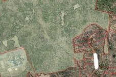
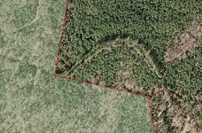
I am researching the area in shaded green and found this odd tree formation around one side. Any ideas. This is a satellite photo and it's not zoomed in very close. The scale is 1:6,253. The reason I am looking at this area, is there a good history back to 1749 in this spot.

The area in question is about 3 times wider than any road on the map.
 

Attachments

  • what is it.jpg
    what is it.jpg
    85 KB · Views: 5,913

wildrider

Bronze Member
Feb 25, 2007
1,895
8
Kentucky
Detector(s) used
Nautilus DMC IIb/White's 6000 Di Pro
Creek bed? Fort entrenchment?

Hope the history is a fort! :)

Good luck!

Burt
 

OP
OP
nc-joe

nc-joe

Hero Member
Dec 1, 2006
710
4
Concord, NC
Detector(s) used
White's DFX and Minelab Explorer SE
Here is another picture to put it into perspective on size. In the lower left corner of the photo is a school with a full size baseball field and in the upper right corner is the tree formation.
 

Attachments

  • trees.jpg
    trees.jpg
    35.5 KB · Views: 5,875

thepirate

Jr. Member
Dec 20, 2006
32
0
Uk
Detector(s) used
Whatever some nice pirate will loan me!!
There looks to be a river or old riverbed to the left of your trees - any evidence of oxbow lakes etc.? The tree formation could follow one of these and may benefit from alluvial deposits for a better growth rate - hope not for your sake! Keep us posted.
 

Old Dog

Gold Member
May 22, 2007
5,860
397
Western Colorado
Looks very much like some of the earlier roads. where the settlers used to prune a bullwork of trees along both sides as a wind break and shelter for travelers. They used to be very commonplace just like covered bridges were long ago. Many of the existing ones are way overgrown as they were never paved. and rarely traveled after the creation of rhe interstate highway system.


OD
 

BamaBill

Hero Member
Nov 8, 2006
686
16
N. Alabama
Detector(s) used
Minelab X-terra 70, AT Pro, Tesoro Tejon, ML X-terra 50
Primary Interest:
Relic Hunting
I think Old Dog is closest with his idea of tree-lined road. The first thing I thought of was the long tree-lined approaches to some of the old Southern Plantations.
 

gollum

Gold Member
Jan 2, 2006
6,729
7,596
Arizona Vagrant
Detector(s) used
Minelab SD2200D (Modded)/ Whites GMT 24k / Fisher FX-3 / Fisher Gold Bug II / Fisher Gemini / Schiebel MIMID / Falcon MD-20
Primary Interest:
All Treasure Hunting
Maybe moundbuilders?

Mike
 

Old Dog

Gold Member
May 22, 2007
5,860
397
Western Colorado
Gollum and faaus could be correct as well.
a natural ridge or mound system could stand out in this fashion.

Have you been into the area and looked it over?
At this point it may be the way to go.
Let us lnow what you see when you get to it.
My interest is peaked.

OD
 

BamaBill

Hero Member
Nov 8, 2006
686
16
N. Alabama
Detector(s) used
Minelab X-terra 70, AT Pro, Tesoro Tejon, ML X-terra 50
Primary Interest:
Relic Hunting
If you really look at it there is two parallel lines of trees that are older than the ones surrounding them. That's what is giving this feature definition and suggests that at one time these older trees were all that was standing in that configuration. If you look at the rest of the photo, I don't see any ridges, so I don't think its likely to be a ridge. I still stick with the idea that it was a road or driveway at one time.
 

Calworks

Sr. Member
Nov 7, 2006
315
7
Looks to me like a drive way, the type that used to run up to those very majestic victorian estates. They look taller and of a different type than those around it. My bet is a drive way as in old wagon, horse carriage drive. bet there's some old stuff in between the trees. People used to take long stolls through the lanes in the evening.

Is that a ghost of Scarlet and Rhett Butler I see???
 

BamaBill

Hero Member
Nov 8, 2006
686
16
N. Alabama
Detector(s) used
Minelab X-terra 70, AT Pro, Tesoro Tejon, ML X-terra 50
Primary Interest:
Relic Hunting
Thanks, that's exactly what I was imagining, in my minds eye seeing the ghosts of Seven Oaks Plantation.
 

eddiebhome

Greenie
Jun 5, 2005
16
0
Clay, Alabama
Detector(s) used
Whites XLT-e
Primary Interest:
All Treasure Hunting
Tin Nugget said:
The trees to the north of the arch or above the arch appear to be planted in rows like was done when a forest was harvested for lumber. Sort of like this. Zoom in and look just to the left.
<a href="http://www.mapquest.com/maps/map.ad...</b></span>&cid=lfmaplink2&name=&dtype=h">Map of Rockland, TX US</a>

What he said.  Looks like unharvested trees along creek or road while harvested area has started to grow back. In fact, "harvested" area trees almost appear to be planted in rows.
 

OP
OP
nc-joe

nc-joe

Hero Member
Dec 1, 2006
710
4
Concord, NC
Detector(s) used
White's DFX and Minelab Explorer SE
I have been out there. The "U" shape are larger pine trees, that's why they stick out. I think the land was used for tree harvest at one time, but for some reason they left 2 rows of trees lining the road going through there. I did not have my camera with me when I was there, but I may try and go back and get a photo. The space between the lines is a road, but due to construction, it is no longer accessable by car, so I will have to hoof it. I did find a late 1700's or early 1800's homesite about 200 yards from these trees. There is a very large hardwood tree, a cellar hole, several foundation stones and a pile of chimney stones. I hunted it for a few hours, but found very little. The most interesting find was a broken buggy suspension spring. I am sure there is more there, I just need to wait until hunting season is over, as there were several deer stands in the area.

I would prefer to be the hunter verse the hunted!
 

Top Member Reactions

Users who are viewing this thread

Top