ClonedSIM
Silver Member
- Joined
- Jul 28, 2005
- Messages
- 3,808
- Reaction score
- 24
- Golden Thread
- 0
- Location
- New Mexico
- Detector(s) used
- White's XLT
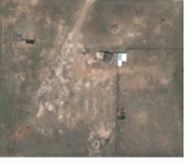
Just for giggles, here's a shot of my land in 2007, before any construction had begun. At the time of this shot, there were absolutely no utilities on the land; the buildings in the center of the shot were and still are used only for storage. Electric was brought in via an overhead line leading to a utility pole on the land, and then the cable was buried from that point until it enters the house. A city water line has been run onto the property, as well as a septic system and leach field. Can you tell where the house or any of the utilities are from this photo? No fair trying to use Google Earth to match the location! :-)
It might be helpful to tell everyone that this land was used by a construction company for many years as a location to store sand and gravel, which explain some of the wear patterns you see. Like a lot of New Mexico, the land is pretty barren, with only a few small yuccas and cacti here and there. The rectangle in the lower right corner is a fenced-in area that was used for equipment storage. Good luck!
Oh, also, if you do happen to run across any gold or silver signals, I'll be more than happy to dig the crap out of the place to find them!


Attachments
Last edited:

 Honestly, this is the same kind of thing I do when I'm out detecting, except I normally avoid areas that have been ditched and refilled as this might cause problems hitting my targets. But, I can still locate them. Does that mean anything?