X Prospect on a topo map

PatrickD

Hero Member
Joined
Jul 23, 2012
Messages
845
Reaction score
706
Golden Thread
0
Location
Colorado
Detector(s) used
Garrett AT Pro
Primary Interest:
All Treasure Hunting
Hi Everyone,

I have been using some topo software to map out areas I want to research.

On the topo is a common mark. It is either an X or two crossed picks. It has the word Prospect next to it.

Now, I understand what prospecting is but I am curious what had to happen for this prospecting site to have ended up on a topo map. Does it mean a claim was filed? Is there a hole in the ground at the location?

Here is a screen shot showing what I am referencing.
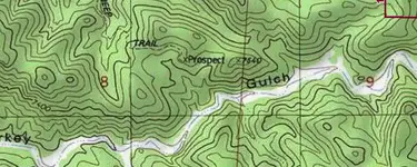
topo map with Prospect.webp

Any ideas or thoughts?

Patrick
 

Upvote 0
From the MRDS:
How Accurate are the Geographic Locations?


My own professional experience as a cartographer is they are about 70% inaccurate. Between duplicates and those locations more than 1/4 mile off from the MRDS location the database is usable only as a mine reference. In conversations with the USGS they agree with my assessment.

We have had conversations with the MRDS stewards about the completion date for the new system. I'm getting the message that without a major funding effort from Congress or dozens of professional cartographers and researchers donating considerable time the project is going nowhere anytime soon. In the meantime 70% accuracy is about the best you will be getting.

Heavy Pans

I don't think that you noticed that the mine locations came from topo maps. Accurate topo maps as quoted in one of my previous posts.

You quote said 4,000 inaccurate. Again there are over 266,000 records. I'd love to know what math you used to calculate a 30% error rate.

(Your post says both 70% inacurate and 70% accurate I'm assuming that you are claiming 70% accurate)

When did the USGS decide to stop updating?


09:27:44 MST
 

Last edited:
Another thing that should be mentioned here is that over the last few decades, much of the information that could be found on topos maps made prior to 1976 has been slowly removed from the current maps. Some will tell you that it is for the public safety and to keep the locations of old mines from being common knowledge. Granted, we as miners know better than to enter any old mine, but those in the general populace without any knowledge of mining and an over blown sense of adventure will enter them without a second thought towards their safety.

When or if you go to the USGS web site to get maps, you will find that the older maps will have a lot more usable information on them when it come to the location of old diggings and other information related to mining. If you get both the older maps and the most recent ones and look at them side by side, the difference is very easy to see.
 

But "What's in the BOX!"? Aside from the accuracy of old topography I'm interested in the OPs success or not of finding something. The jeep trail. Any signs. Old trash. Anything???
 

Hi Goldog,

That site is about 2 miles from me. (Yes, I live in the mountains in Colorado.)

So, here is the deal on that site. I am going back. But, my 4 wheel drive was having some major issues and had to put it in the shop this week. 144k plus miles and doing a major engine overhaul. The lower seal and head gasket were both broken. I am supposed to get it back on Friday. If so, I will be testing it on Saturday going back to this spot.

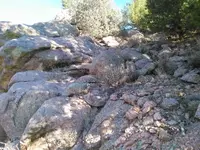
On an interesting note, I was walking the dry gulch bed and there are numerous rock outcroppings but one was a huge, bigger than a grown person huge, boulder of dirty quartz with a lot of fools gold on the surface. I took a little sample and put it in my kitchen window sill. The gold color is kind of ornamental.

I will definitely update this with what I find. I will get pictures as well. I have company coming next week so have to get ready for that visit too.

If I can find that X Prospect site, I will photo it well and share. I had to be near it already. I have been down that jeep trail twice. I only ran across the issue when looking the site up in my topo software to see where I had been.

I really appreciate all of the good information people contributed here. It was like a drink from a firehose trying to keep up with it. Problems like this I need more of.

Patrick
 

Last edited:
for every "prospect" on a map I usually find a half dozen more nearby that aren't on it. The accuracy of what is on most "x" marks the spot online "gold maps" is so off its ridiculous. I have a millsite on the edge of my property that is listed in two places and and most of the mines near my house are shown in two to three different places sometimes on the same map.
You won't figure these things out unless you actually go out and get boots on the ground.
 

And by the way, if you haven't introduced yourself to KevinInColorado, you should. He's kinda busy right now but he will set you on the path to righteous gold in CO. :notworthy:
 

for every "prospect" on a map I usually find a half dozen more nearby that aren't on it. The accuracy of what is on most "x" marks the spot online "gold maps" is so off its ridiculous. I have a millsite on the edge of my property that is listed in two places and and most of the mines near my house are shown in two to three different places sometimes on the same map.
You won't figure these things out unless you actually go out and get boots on the ground.

Wow, isn't that the truth. I have been doing cache hunting for as long as I can remember since I could walk. You find the same thing when trying to compile treasure leads. I have found it takes ten times the amount of field research to get close to something than all the previous and ongoing historical research. Those maps at best are a 'general vicinity' thing on certain types of place markers.
 

And by the way, if you haven't introduced yourself to KevinInColorado, you should. He's kinda busy right now but he will set you on the path to righteous gold in CO. :notworthy:

Oh, I have met him. Great guy. He isn't that far away from me, maybe a two to three hour drive.

He has already been an inspiration and great source of information.
 

Hi Everyone,

Just a quick FYI. I have a slight delay on my 4 wheel drive. I was supposed to get it yesterday. It wasn't finished so I am supposed to pick it up on Monday. I will try to get out to that sight to take some pictures. If Monday doesn't work out, I will have to wait until my out-of-state guests finish their visit.

Patrick
 

Best of luck to PatrickD. Go forth and find gold. Good hunting and good luck.
 

I'm looking forward to seeing what you find. Finding old workings, prospects, and mines is fascinating to me. Last time I was at my claim, I spent a good hour looking for a mine shaft that I know is there, when I should have been mining...
 

Ok, finally got control of my time again. My 4 wheel drive is back and doing great and my company has come and gone. It is always a great feeling to spend time with good friends.

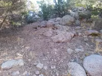
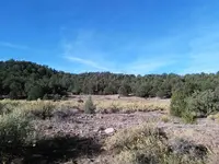
I went back up to that spot today and looked around. Here are some photos.

IMG_20161023_090516.webp

IMG_20161023_090717.webp

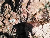
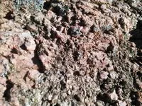
Here is that dirty quartz with the pyrite through it.

IMG_20161023_090645.webp

IMG_20161023_090626.webp

IMG_20161023_090703.webp
 

Top Member Reactions

Users who are viewing this thread

Back
Top Bottom