BuffaloBob
Bronze Member
- Jan 6, 2005
- 1,367
- 262
- Detector(s) used
-
Minelab X-Terra 705 Gold Coil
deteknixXpointer Probe
Minelab Ex-Terra 70
White's Classic II
2014-2015 Colorado Gold Camp Prospector
- Primary Interest:
- Metal Detecting
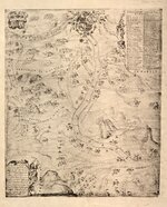
MAP 1744
Covers the territory from Santa Fé west to the Colorado River and south to the Chihuaha
Spanish travelers map. From Library of Congress.. http://www.loc.gov/item/2011590182/
BB

Covers the territory from Santa Fé west to the Colorado River and south to the Chihuaha
Spanish travelers map. From Library of Congress.. http://www.loc.gov/item/2011590182/
BB


