- Thread starter
- #181
Does anybody know the places where LUE caches were said to be found? Thank you.
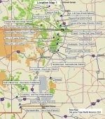
Another full circle trip here.Alleged locations revealed over the years:
Karl published a letter from Mary Lou Karsten Phillips in NPG Vol 11 No. 3 (Feb-May 1981) where the following locations are indicated (Karl prints this, does not dispute any of it)
*San Francisco Peak,
*Elizabethtown,
*Black Lake,
*Mora,
*Romeroville,
*"further north somewhere near Salida [CO]
Karl would confirm some of these in an Ask Exanimo column published in the April 1981 issue of Western Eastern Treasures:
*San Francisco Peak in Colorado,
*Black Lake
*Mora
*Carrizozo.
There is some confusion about the San Francisco Peak site, though he clarified to Boyd Jolley in the June 1991 issue of Treasure magazine noting the site was at "San Francisco Peak near San Francisco pass." [CO]. Also in the same issue, Karl notes (to Boyd Jolley): "The caches at Black Lake and south of Mora have been cleaned out. I know nothing about the cache area at Elizabethtown,...and how much has been removed from the area around San
Francisco is unknown to me."
In a letter to Larry Goddard, Karl wrote of a site SE of Trinidad [CO], noting he got "run out" of the site. He never published this one, perhaps because he was never able to confirm it on site.
In separate letters to Johnny Pounds, Milton Rose and Larry Goddard, Karl mentions San Luis Valley as a cache point for the LUE, he indicates he felt this was the area Patrick Donnell's father, Jim, was looking for the LUE. Karl mentions the recovery at San Francisco Peak being near San Luis Valley, so these in fact may be the same recovery site.
I have a letter here from Karl to Michael Paul Henson, I where he also mentions a recovery at Amaya, New Mexico.
Randy
He must have been referring to Francisco Peak in the Sangre de Cristos, just north of Culebra Peak. In fact, claiming it was in the San Luis Valley seems to indicate it was on the western slope.
Nothing specific but there are some interesting bits of connective tissue.Was there something about Mesa Uraca that includes it in the LUE legend?
Thank you Randy.Nothing specific but there are some interesting bits of connective tissue.
"Its name [LUE] was coined from the first three words that appeared on the map: “Lloro, Urraca and Enterrari.”
This was noted many times by Karl in his writings and poses a somewhat confusing clue. Karl's original version of the LUE from the 1966 THM #7 was noted as an exact copy of the map. Clearly these words are not on the map. This means either Karl lied, Karl was mistaken, OR, and I like to believe this, it was written on the back of the map. This is the most deliberate form of speculation on my part, of course.
Interestingly, Uracca Mesa is only about 50 miles from Black Lake, though much, muck closer as the Eagle flies (not to be confused with Eagle's Nest).

Uracca Mesa has been owned by the Boy Scouts who own a large tract of land down that way. I tend to wonder if the Scouts will sell the property in the wake of their bankruptcy.
Regarding the interpretation of “Lloro, Urraca and Enterrari”, I reprint the following from my presentation transcript:
Now he [Boyd Jolley] claimed that he had a letter from Karl von Mueller that suggested that the LUE was based
on the words “Lloro, Urraca and Enterrari”. You’ll have to pardon me, Spanish is not my second language. And if we Look at sort of the meanings of those words, I googled this. Spanish (for Lloro) is to cry or to weep. Urraca is a proper name, I believe a woman's name, but it's derived from the Latin “thievish” and interestingly enough in the actual sort of LUE recovery area there is a Mesa called Urraca [Uracca is also translated to English as Magpie]. And then Enterrari, is to bury or to inter. So if you string it all together it potentially means “Urraca cries because it is buried.”