You are using an out of date browser. It may not display this or other websites correctly.
You should upgrade or use an alternative browser.
You should upgrade or use an alternative browser.
LUE MAP THEORY, MAYBE SOME CONTEXT
- Thread starter mdog
- Start date
Alleged locations revealed over the years:
Karl published a letter from Mary Lou Karsten Phillips in NPG Vol 11 No. 3 (Feb-May 1981) where the following locations are indicated (Karl prints this, does not dispute any of it)
*San Francisco Peak,
*Elizabethtown,
*Black Lake,
*Mora,
*Romeroville,
*"further north somewhere near Salida [CO]
Karl would confirm some of these in an Ask Exanimo column published in the April 1981 issue of Western Eastern Treasures:
*San Francisco Peak in Colorado,
*Black Lake
*Mora
*Carrizozo.
There is some confusion about the San Francisco Peak site, though he clarified to Boyd Jolley in the June 1991 issue of Treasure magazine noting the site was at "San Francisco Peak near San Francisco pass." [CO]. Also in the same issue, Karl notes (to Boyd Jolley): "The caches at Black Lake and south of Mora have been cleaned out. I know nothing about the cache area at Elizabethtown,...and how much has been removed from the area around San
Francisco is unknown to me."
In a letter to Larry Goddard, Karl wrote of a site SE of Trinidad [CO], noting he got "run out" of the site. He never published this one, perhaps because he was never able to confirm it on site.
In separate letters to Johnny Pounds, Milton Rose and Larry Goddard, Karl mentions San Luis Valley as a cache point for the LUE, he indicates he felt this was the area Patrick Donnell's father, Jim, was looking for the LUE. Karl mentions the recovery at San Francisco Peak being near San Luis Valley, so these in fact may be the same recovery site.
I have a letter here from Karl to Michael Paul Henson, I where he also mentions a recovery at Amaya, New Mexico.
Randy
sdcfia
Silver Member
Another full circle trip here.Alleged locations revealed over the years:
Karl published a letter from Mary Lou Karsten Phillips in NPG Vol 11 No. 3 (Feb-May 1981) where the following locations are indicated (Karl prints this, does not dispute any of it)
*San Francisco Peak,
*Elizabethtown,
*Black Lake,
*Mora,
*Romeroville,
*"further north somewhere near Salida [CO]
Karl would confirm some of these in an Ask Exanimo column published in the April 1981 issue of Western Eastern Treasures:
*San Francisco Peak in Colorado,
*Black Lake
*Mora
*Carrizozo.
There is some confusion about the San Francisco Peak site, though he clarified to Boyd Jolley in the June 1991 issue of Treasure magazine noting the site was at "San Francisco Peak near San Francisco pass." [CO]. Also in the same issue, Karl notes (to Boyd Jolley): "The caches at Black Lake and south of Mora have been cleaned out. I know nothing about the cache area at Elizabethtown,...and how much has been removed from the area around San
Francisco is unknown to me."
In a letter to Larry Goddard, Karl wrote of a site SE of Trinidad [CO], noting he got "run out" of the site. He never published this one, perhaps because he was never able to confirm it on site.
In separate letters to Johnny Pounds, Milton Rose and Larry Goddard, Karl mentions San Luis Valley as a cache point for the LUE, he indicates he felt this was the area Patrick Donnell's father, Jim, was looking for the LUE. Karl mentions the recovery at San Francisco Peak being near San Luis Valley, so these in fact may be the same recovery site.
I have a letter here from Karl to Michael Paul Henson, I where he also mentions a recovery at Amaya, New Mexico.
Randy
For me, the primary problem with this treasure trove legend is the allegation of so many diverse locations/"recoveries" for one tale. Whether intentional or not, it smells strongly of disinformation. To what depth? Caveat emptor. By the way, for clarity, there is a Francisco Peak four miles north of Culebra Peak, and "Amaya" does not appear on any maps or place name databases in New Mexico. Sounds like a Hispanic name/surname.
If there is any truth at all to the original history - and "Karl"s knowledge of it - and if I were to spend time on a search, I would assume there is a single cache/hidden mine somewhere in the vicinity of the upper Pugatoire River watershed. Possibly a KGC site vis-a-vis the TOTVOS anomaly. The remainder of the list of "LUE" sites sounds like a mishmash of other separate tales or simply unadulterated BS.
Unfortunately, "Karl" was the primary pusher of the "LUE". "Karl" may have been a KGC asset, knowingly or not. To all who have solved the riddle and made recoveries - congratulations. For me, mdog's map work is a very interesting twist to the whole shebang.
Last edited:
Amaya came from a two-sided letter where the ink bled through and was my best guess...it may also refer to a ghost town...I'll try and crop that part of the letter and post it and see what folks think.
sdcfia
Silver Member
He must have been referring to Francisco Peak in the Sangre de Cristos, just north of Culebra Peak. In fact, claiming it was in the San Luis Valley seems to indicate it was on the western slope.
It would take some personal inquiries to validate the following from ChatGPT (just sayin'):
"Yes, there was indeed a mining camp near Elizabethtown, New Mexico, called Anaya. Elizabethtown itself was a bustling mining town in the late 19th century due to the presence of gold mines in the area. Anaya was one of several smaller mining camps or settlements that sprang up in the vicinity as part of the mining boom."
You all might find this interesting as well:
This was part of a discussion thread on the LUE on another thread on Treasurenet. Originally posted by aw11mr2 at:
Hands down one of the best threads I've ever seen in terms of succinctly talking about the LUE locations.
* * * * * * *
I found a piece of information that might be coincidental or related to the LUE in The Treasure Hunter’s Manual, 7th Edition, Chapter VI, HOW. There is a story titled New Mexican $$$ provided as an example how to research a treasure project. The project begins in Las Vegas, New Mexico and continues north to an area west of Trinidad, Colorado. The treasure lead starts with a cave discovered by kids in 1899 near Tecelote Creek, west of Las Vegas, New Mexico. The cave contained old documents believed to be related to mission activities. The cave was later investigated and apparently enough gold was removed that the discoverers agreed “to not take any more gold from the cave unless it was needed, and it was never needed.” Based on this story, a group got together to investigate the tale. Their research indicated that there were several caves in the area and the site was likely on private property. The project moved on to research three potential mission sites.
1. “Near the old town of Las Colonas (on the Rio de La Vaco fork of the Pecos river)” , “. . . at the foot of El Barro Peak.”
2. “Near Guadalupita on the old Mora Grant (north of the present city of Mora).”
3. “Near the Colorado-New Mexico state line on the old Taos-Trinidad road.” The locations of the mission/church/town sites in this area were described in relation to the former town of Catskill (platted in 1890).
The former town of Catskill was situated at the end of the Denver Texas & Fort Worth railroad spur line from Trinidad, CO to the Canadian River in New Mexico.
The description of the payoff is what really interested me. Although the group found one of seven potential sites, they still recovered 390 ounces of gold nuggets and dust! Karl von Mueller mentions that one of the sites investigated might be related to the Rutledge or Bloomington, Nebraska treasure (money, gold ingots and nuggets) discussed in The Treasure Hunter’s Manual, 6th Edition.
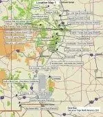
Plotting these sites on a map shows a general north-south trend in the Sangre de Cristo Mountains and potential relationship with the Continental Divide in southwest New Mexico.

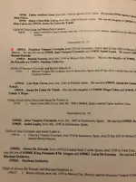
Near Salida, CO – Potential cache area (Randy Bradford’s Treasurenet.com forum post (Nov. 27, 2016): 1981 issue (Vol.? No.?) of National Prospector’s Gazette - May Lou Karsting Phillips to Karl von Mueller)
Former Spanish Fort in CO – Example of early Spanish occupation in Colorado. In the text that accompanies Historic Trail Map of Trinidad 1° x 2° Quadrangle, USGS Investigation Geologic Series I-2745 (Available online): “Fort Sangre de Cristo, Malagres Fort, built in 1819 by Governor Don Facundo Malagres about 3(?) miles northeast of Sangre de Cristo Pass.” Also see pages 30-32 of History of Upper Huerfano Valley by Jeannette F. Thach, Colorado Magazine, Vol. 38 No. 1, January 1961 (Available online).
West of Rye, CO – LUE Cave of Gold (PatrickD’s Treasurenet.com forum post): Possibly the nearest town to the Blue Lake cache near Greenhorn Mountain.
Near Conejos Peak, CO – Rock carving containing similar symbols found on the LUE map (Treasure of the Valley of Secrets, Deek Gladson, 1971)
Treasure of the Valley of Secrets – West of Trinidad, Colorado, near the headwater of Purgatoire River. I have no idea of the location and stuck a pin near the headwaters of the North fork of the Purgatoire River. (The Scarlet Shadow, Walter Hurt, 1907 and Treasure Hunter’s Manual #6, revised 1973)
San Francisco Peak, CO – Potential cache area (1981 NPG: May Lou Karsting Phillips to KvM) (Randy Bradford’s Treasurenet.com forum post (Nov. 27, 2016): Karl von Mueller in a 1981 issue (Vol.? No.?) of Western & Eastern Treasures magazine): Teasurenet member “Mdog” asked (Dec. 10, 2016) where San Francisco Peak was located. I couldn’t locate a Colorado peak, however, west of Trinidad, less than 13 miles apart from one another, are two San Francisco passes and a Francisco Peak.
San Francisco Pass – 9,150 feet. Trends north-south “From Bonita Canyon Branch of Vallejos Creek to North Fork of Vermejo River, Las Animas County.”
Location shown on Historic Trail Map of Trinidad 1° x 2° Quadrangle (Includes a pamphlet that accompany map), Glenn R. Scott, 2001, USGS Geologic Investigation Series I-274.
Lat. N37° 1’ 29.1” Long. W105° 5’ 56.5” (WGS84)
San Francisco Pass (Costilla Pass) – “Separates Ricardo Creek from San Francisco Creek, on Culebra Range of the Sangre de Cristo Mountains, Costilla County.”
Location shown on Historic Trail Map of Trinidad 1° x 2° Quadrangle, USGS Geologic Investigation Series I-2745.
Lat. N37° 1’ 20.7” Long. W105° 15’ 54.9” (WGS84)
Francisco Peak - Elevation: 13, 135 feet. Lat. N37° 10’ 56.05” Long. W105° 59’ 57.95” (WGS84)

Potential source of the Rutledge/Bloomington Treasure - Gold ingots and nuggets buried on the Rutledge property in Bloomington, Nebraska (Treasure Hunter’s Manual #7, 1966).
Catskill, NM – Former gold camp and later a lumber camp (THM #7).
Lat. N36° 56’ 23.07” Long. W104° 48’ 25.94” (WGS84)
Elizabethtown, NM – Potential cache area (1981 NPG - May Phillips to KvM)
West side of Taos, NM – LUE cache (silver bars) recovery (PatrickD)
Black Lake, NM – LUE cache (partial recovery?) (1981 NPG - May Phillips to KvM) (KvM in 1981 W&E Treasures) (PatrickD)
Guadalupita, NM – Church site (THM #7)
Mora, NM – Potential cache area (1981 NPG - May Phillips to KvM) (KvM in 1981 W&E Treasures)
Near La Cueva, NM – Rock carving containing similar symbols found on the LUE map (TotVoS).
Near Tecolote Creek, NM – Potential church gold cache hidden in cave west of Las Vegas, NM (THM #7).
Romeroville, NM – Potential cache area (1981 NPG - May Phillips to KvM)
Los Colonas, NM – Church site (THM #7)
Carrizozo, NM – Potential cache area (KvM in 1981 W&E Treasures)
South of Black Peak, NM – Potential Spanish(?) cache site (New Mexico Confidential – 30 Years of Snooping in Obscure Places, Stephen D. Clark, 2013)
Lordsburg, NM – LUE Cave of Gold (PatrickD): Possibly cited because it is the largest commonly known town near the Hachita Peak cache and Big Hatchet Mountains cave of gold sites.


This was part of a discussion thread on the LUE on another thread on Treasurenet. Originally posted by aw11mr2 at:
https://www.treasurenet.com/threads/lue-clue-the-obit-of-hardrock-hammond.520733/page-5#post-5786777
Hands down one of the best threads I've ever seen in terms of succinctly talking about the LUE locations.
* * * * * * *
I found a piece of information that might be coincidental or related to the LUE in The Treasure Hunter’s Manual, 7th Edition, Chapter VI, HOW. There is a story titled New Mexican $$$ provided as an example how to research a treasure project. The project begins in Las Vegas, New Mexico and continues north to an area west of Trinidad, Colorado. The treasure lead starts with a cave discovered by kids in 1899 near Tecelote Creek, west of Las Vegas, New Mexico. The cave contained old documents believed to be related to mission activities. The cave was later investigated and apparently enough gold was removed that the discoverers agreed “to not take any more gold from the cave unless it was needed, and it was never needed.” Based on this story, a group got together to investigate the tale. Their research indicated that there were several caves in the area and the site was likely on private property. The project moved on to research three potential mission sites.
1. “Near the old town of Las Colonas (on the Rio de La Vaco fork of the Pecos river)” , “. . . at the foot of El Barro Peak.”
2. “Near Guadalupita on the old Mora Grant (north of the present city of Mora).”
3. “Near the Colorado-New Mexico state line on the old Taos-Trinidad road.” The locations of the mission/church/town sites in this area were described in relation to the former town of Catskill (platted in 1890).
The former town of Catskill was situated at the end of the Denver Texas & Fort Worth railroad spur line from Trinidad, CO to the Canadian River in New Mexico.
The description of the payoff is what really interested me. Although the group found one of seven potential sites, they still recovered 390 ounces of gold nuggets and dust! Karl von Mueller mentions that one of the sites investigated might be related to the Rutledge or Bloomington, Nebraska treasure (money, gold ingots and nuggets) discussed in The Treasure Hunter’s Manual, 6th Edition.
Plotting these sites on a map shows a general north-south trend in the Sangre de Cristo Mountains and potential relationship with the Continental Divide in southwest New Mexico.
Near Salida, CO – Potential cache area (Randy Bradford’s Treasurenet.com forum post (Nov. 27, 2016): 1981 issue (Vol.? No.?) of National Prospector’s Gazette - May Lou Karsting Phillips to Karl von Mueller)
Former Spanish Fort in CO – Example of early Spanish occupation in Colorado. In the text that accompanies Historic Trail Map of Trinidad 1° x 2° Quadrangle, USGS Investigation Geologic Series I-2745 (Available online): “Fort Sangre de Cristo, Malagres Fort, built in 1819 by Governor Don Facundo Malagres about 3(?) miles northeast of Sangre de Cristo Pass.” Also see pages 30-32 of History of Upper Huerfano Valley by Jeannette F. Thach, Colorado Magazine, Vol. 38 No. 1, January 1961 (Available online).
West of Rye, CO – LUE Cave of Gold (PatrickD’s Treasurenet.com forum post): Possibly the nearest town to the Blue Lake cache near Greenhorn Mountain.
Near Conejos Peak, CO – Rock carving containing similar symbols found on the LUE map (Treasure of the Valley of Secrets, Deek Gladson, 1971)
Treasure of the Valley of Secrets – West of Trinidad, Colorado, near the headwater of Purgatoire River. I have no idea of the location and stuck a pin near the headwaters of the North fork of the Purgatoire River. (The Scarlet Shadow, Walter Hurt, 1907 and Treasure Hunter’s Manual #6, revised 1973)
San Francisco Peak, CO – Potential cache area (1981 NPG: May Lou Karsting Phillips to KvM) (Randy Bradford’s Treasurenet.com forum post (Nov. 27, 2016): Karl von Mueller in a 1981 issue (Vol.? No.?) of Western & Eastern Treasures magazine): Teasurenet member “Mdog” asked (Dec. 10, 2016) where San Francisco Peak was located. I couldn’t locate a Colorado peak, however, west of Trinidad, less than 13 miles apart from one another, are two San Francisco passes and a Francisco Peak.
San Francisco Pass – 9,150 feet. Trends north-south “From Bonita Canyon Branch of Vallejos Creek to North Fork of Vermejo River, Las Animas County.”
Location shown on Historic Trail Map of Trinidad 1° x 2° Quadrangle (Includes a pamphlet that accompany map), Glenn R. Scott, 2001, USGS Geologic Investigation Series I-274.
Lat. N37° 1’ 29.1” Long. W105° 5’ 56.5” (WGS84)
San Francisco Pass (Costilla Pass) – “Separates Ricardo Creek from San Francisco Creek, on Culebra Range of the Sangre de Cristo Mountains, Costilla County.”
Location shown on Historic Trail Map of Trinidad 1° x 2° Quadrangle, USGS Geologic Investigation Series I-2745.
Lat. N37° 1’ 20.7” Long. W105° 15’ 54.9” (WGS84)
Francisco Peak - Elevation: 13, 135 feet. Lat. N37° 10’ 56.05” Long. W105° 59’ 57.95” (WGS84)
Potential source of the Rutledge/Bloomington Treasure - Gold ingots and nuggets buried on the Rutledge property in Bloomington, Nebraska (Treasure Hunter’s Manual #7, 1966).
Catskill, NM – Former gold camp and later a lumber camp (THM #7).
Lat. N36° 56’ 23.07” Long. W104° 48’ 25.94” (WGS84)
Elizabethtown, NM – Potential cache area (1981 NPG - May Phillips to KvM)
West side of Taos, NM – LUE cache (silver bars) recovery (PatrickD)
Black Lake, NM – LUE cache (partial recovery?) (1981 NPG - May Phillips to KvM) (KvM in 1981 W&E Treasures) (PatrickD)
Guadalupita, NM – Church site (THM #7)
Mora, NM – Potential cache area (1981 NPG - May Phillips to KvM) (KvM in 1981 W&E Treasures)
Near La Cueva, NM – Rock carving containing similar symbols found on the LUE map (TotVoS).
Near Tecolote Creek, NM – Potential church gold cache hidden in cave west of Las Vegas, NM (THM #7).
Romeroville, NM – Potential cache area (1981 NPG - May Phillips to KvM)
Los Colonas, NM – Church site (THM #7)
Carrizozo, NM – Potential cache area (KvM in 1981 W&E Treasures)
South of Black Peak, NM – Potential Spanish(?) cache site (New Mexico Confidential – 30 Years of Snooping in Obscure Places, Stephen D. Clark, 2013)
Lordsburg, NM – LUE Cave of Gold (PatrickD): Possibly cited because it is the largest commonly known town near the Hachita Peak cache and Big Hatchet Mountains cave of gold sites.
Attachments
The original post of the above has better, larger versions of the attached maps for those interested. I've tried making a master list of LUE threads before but you lose the ability to edit after a certain time period which makes updating a "master thread" impossible.
That said, there's a lot of interesting stuff out there (and a lot of trash, unfortunately) if you have the time and patience to sift threads for it.
That said, there's a lot of interesting stuff out there (and a lot of trash, unfortunately) if you have the time and patience to sift threads for it.
- #189
Thread Owner
Randy Bradford and sdcfia, thank you very much for the excellent information.
I'm working on my theory about the overlay. It seems like you might be able to slide the starting point down the 105deg W longitude. I still have to do a lot of work before I know for sure.
Thanks again to both of you.
Was there something about Mesa Uraca that includes it in the LUE legend?
I'm working on my theory about the overlay. It seems like you might be able to slide the starting point down the 105deg W longitude. I still have to do a lot of work before I know for sure.
Thanks again to both of you.
Was there something about Mesa Uraca that includes it in the LUE legend?
Nothing specific but there are some interesting bits of connective tissue.Was there something about Mesa Uraca that includes it in the LUE legend?
"Its name [LUE] was coined from the first three words that appeared on the map: “Lloro, Urraca and Enterrari.”
This was noted many times by Karl in his writings and poses a somewhat confusing clue. Karl's original version of the LUE from the 1966 THM #7 was noted as an exact copy of the map. Clearly these words are not on the map. This means either Karl lied, Karl was mistaken, OR, and I like to believe this, it was written on the back of the map. This is the most deliberate form of speculation on my part, of course.
Interestingly, Uracca Mesa is only about 50 miles from Black Lake, though much, muck closer as the Eagle flies (not to be confused with Eagle's Nest).
Uracca Mesa has been owned by the Boy Scouts who own a large tract of land down that way. I tend to wonder if the Scouts will sell the property in the wake of their bankruptcy.
Regarding the interpretation of “Lloro, Urraca and Enterrari”, I reprint the following from my presentation transcript:
Now he [Boyd Jolley] claimed that he had a letter from Karl von Mueller that suggested that the LUE was based
on the words “Lloro, Urraca and Enterrari”. You’ll have to pardon me, Spanish is not my second language. And if we Look at sort of the meanings of those words, I googled this. Spanish (for Lloro) is to cry or to weep. Urraca is a proper name, I believe a woman's name, but it's derived from the Latin “thievish” and interestingly enough in the actual sort of LUE recovery area there is a Mesa called Urraca [Uracca is also translated to English as Magpie]. And then Enterrari, is to bury or to inter. So if you string it all together it potentially means “Urraca cries because it is buried.”
Last edited:
- #191
Thread Owner
Thank you Randy.Nothing specific but there are some interesting bits of connective tissue.
"Its name [LUE] was coined from the first three words that appeared on the map: “Lloro, Urraca and Enterrari.”
This was noted many times by Karl in his writings and poses a somewhat confusing clue. Karl's original version of the LUE from the 1966 THM #7 was noted as an exact copy of the map. Clearly these words are not on the map. This means either Karl lied, Karl was mistaken, OR, and I like to believe this, it was written on the back of the map. This is the most deliberate form of speculation on my part, of course.
Interestingly, Uracca Mesa is only about 50 miles from Black Lake, though much, muck closer as the Eagle flies (not to be confused with Eagle's Nest).

Uracca Mesa has been owned by the Boy Scouts who own a large tract of land down that way. I tend to wonder if the Scouts will sell the property in the wake of their bankruptcy.
Regarding the interpretation of “Lloro, Urraca and Enterrari”, I reprint the following from my presentation transcript:
Now he [Boyd Jolley] claimed that he had a letter from Karl von Mueller that suggested that the LUE was based
on the words “Lloro, Urraca and Enterrari”. You’ll have to pardon me, Spanish is not my second language. And if we Look at sort of the meanings of those words, I googled this. Spanish (for Lloro) is to cry or to weep. Urraca is a proper name, I believe a woman's name, but it's derived from the Latin “thievish” and interestingly enough in the actual sort of LUE recovery area there is a Mesa called Urraca [Uracca is also translated to English as Magpie]. And then Enterrari, is to bury or to inter. So if you string it all together it potentially means “Urraca cries because it is buried.”
- #192
Thread Owner
My theory about the starting point sliding down the 105deg longitude didn't work out with the cache locations provided.Randy Bradford and sdcfia, thank you very much for the excellent information.
I'm working on my theory about the overlay. It seems like you might be able to slide the starting point down the 105deg W longitude. I still have to do a lot of work before I know for sure.
Thanks again to both of you.
Was there something about Mesa Uraca that includes it in the LUE legend?
Keep trying, sounds like you're onto something...My theory about the starting point sliding down the 105deg longitude didn't work out with the cache locations provided.
- #194
Thread Owner
After spending several hours, over two days, I couldn't find any connection between the Sun ray headings on the LUE clue and reported LUE cache sites west of the 105deg longitude. I was about to give up on the headings but than I remembered one of the first posts that I made on this thread. In my post 3, I wrote that in 1926 ten men initiated an effort to raise $300,000 to erect a 204 foot obelisk at the discovery site of the Kensington Runestone. Eight of those men were Masons. I decided to run the LUE clue Sun headings using the runestone discovery site as a starting point. This map shows the google earth paths created by the LUE clue headings. The red lines are the LUE clue headings. Sorry about the poor quality of the map.

Nothing really stood out until I plotted the 134deg heading. That line intersected two other lines right by Fort Knox, Kentucky. When I plotted the 119deg heading, I saw that line intersected two other lines by Montvale, Virginia, a place associated with the Beale treasure legend.
The lines that intersect by Fort Knox are:
1. The line from Treasure Mountain, Colorado to Montvale, Virginia (Beale Treasure).
2. The line from Wildcat Bluff, Arkansas (Black Book Legend) to the Oak Island Money Pit.
3. The 134deg LUE clue heading from the Kensington Runestone. This heading came from the LUE clue.
The lines that intersect at Montvale, Virginia are:
1. The line that comes from the Oak Island Money Pit to Montvale, Virginia, also passing by the Capitol Building in Washington D.C.
2. The line coming from Treasure Mountain, Colorado to Montvale, Virginia.
3. The 119deg heading from the Kensington Runestone. This heading came from the LUE clue.
Here is a picture showing the intersections at Fort Knox and Montvale.

Here's the LUE clue with the Sun ray headings shown.

I believe in coincidence. If I go to get groceries and I run into my sister at the store, that's a coincidence. However, three intersecting lines over two related places, seems to be well planned. I also remember Von Mueller's comment about Fort Knox, when he introduced the LUE clue.
Anyway I have more work ahead of me, checking out the LUE headings on the Kensington Runestone mapping.
Nothing really stood out until I plotted the 134deg heading. That line intersected two other lines right by Fort Knox, Kentucky. When I plotted the 119deg heading, I saw that line intersected two other lines by Montvale, Virginia, a place associated with the Beale treasure legend.
The lines that intersect by Fort Knox are:
1. The line from Treasure Mountain, Colorado to Montvale, Virginia (Beale Treasure).
2. The line from Wildcat Bluff, Arkansas (Black Book Legend) to the Oak Island Money Pit.
3. The 134deg LUE clue heading from the Kensington Runestone. This heading came from the LUE clue.
The lines that intersect at Montvale, Virginia are:
1. The line that comes from the Oak Island Money Pit to Montvale, Virginia, also passing by the Capitol Building in Washington D.C.
2. The line coming from Treasure Mountain, Colorado to Montvale, Virginia.
3. The 119deg heading from the Kensington Runestone. This heading came from the LUE clue.
Here is a picture showing the intersections at Fort Knox and Montvale.
Here's the LUE clue with the Sun ray headings shown.
I believe in coincidence. If I go to get groceries and I run into my sister at the store, that's a coincidence. However, three intersecting lines over two related places, seems to be well planned. I also remember Von Mueller's comment about Fort Knox, when he introduced the LUE clue.
Anyway I have more work ahead of me, checking out the LUE headings on the Kensington Runestone mapping.
- #195
Thread Owner
Here's something interesting.
I was looking along the 103.5deg LUE heading from the Kensington Runestone and the line ran right through the town of St. Mary's, Pennsylvania. St. Mary's was the last location that a Union gold shipment was seen, during the Civil War. Sixteen miles SE of St. Mary's, and 2.5 miles off the line, is a place called Dent's Run. I believe this is the place where the FBI allegedly removed gold bullion from a place that had been found by a treasure hunter. If the FBI did make a bullion recovery, than I guess they recovered a LUE cache.
 visitpago.com

I was looking along the 103.5deg LUE heading from the Kensington Runestone and the line ran right through the town of St. Mary's, Pennsylvania. St. Mary's was the last location that a Union gold shipment was seen, during the Civil War. Sixteen miles SE of St. Mary's, and 2.5 miles off the line, is a place called Dent's Run. I believe this is the place where the FBI allegedly removed gold bullion from a place that had been found by a treasure hunter. If the FBI did make a bullion recovery, than I guess they recovered a LUE cache.
Legend of the Lost Gold of Dents Run | Visit PA Great Outdoors
Federal Agents searching for “something” within a large secured area brought the Legend of the Lost Gold of Dents Run back into the media spotlight in 2019. The year was 1863. Legends states that a Union wagon train left Wheeling, West Virginia with 52 bars of gold, each weighing 50 pounds...
visitpago.com
- #196
Thread Owner
The LUE clue's 196deg heading from the Kensington Runestone, goes through central Texas past the towns of Aspermont, Clyde and Rotan. Three of the Spider Rock stones were found close to these towns.
All of these towns are well off the LUE clue heading of 196deg, but forming a triangle and connecting points to midpoints shows intersecting lines 1.75 miles off the LUE heading.


All of these towns are well off the LUE clue heading of 196deg, but forming a triangle and connecting points to midpoints shows intersecting lines 1.75 miles off the LUE heading.
LUE-Hawn
Sr. Member
- Joined
- Feb 16, 2018
- Messages
- 416
- Reaction score
- 355
- Golden Thread
- 0
- Location
- United States
- Detector(s) used
- Minelab SDC 2300, Makro Deephunter Pro 3D, OKM EXP 4500 Pro, Garrett Hand Held Detectors, Falcon MD 20, English dowsing springs, Darley Spanish Dip Needle, L-Rods, what’s left of my brain :o)
- Primary Interest:
- All Treasure Hunting
To All,
Here is Some Family History as it relates to this area and then some.
Oldest first: My famous ancestor was the third wife of Cristobal Colon aka Christopher Columbus. Her father was Bartolomeu Perestrello who was a cartographer and it was said he gave the maps to the new world to Christopher Columbus. Bartolomeu Perestrello was a member of the Knights of Christ an offshoot of the Knights Templar in Portugal.
One of his daughters, Filipa Moniz Perestrelo (born c. 1455), around 1479 married Christopher Columbus,[2] who lived in Madeira and Porto Santo.
Filipa Moniz Perestrelo (c. 1455 – between 1479 and 1484) was a Portuguese noblewoman from Porto Santo Island, in Madeira, Portugal. She married Christopher Columbus in 1479 at Vila Baleira on the island.
Second historical ancestor: Most sources regard him as one of the three blacksmiths that served under the expedition of Conquistador Fernando Cortes when they invaded the Aztec Empire in Mexico 1519 to 1521.
Third famous and historical ancestor: Francisco Vázquez de Coronado was a Spanish conquistador and explorer who led a large expedition from what is now Mexico to present-day Kansas through parts of the southwestern United States between 1540 and 1542. Vázquez de Coronado had hoped to reach the Cities of Cíbola, often referred to now as the mythical Seven Cities of Gold.
Isn’t family history interesting? I can follow our family history back to the 12th century in Italy.
Bests in Treasures
LUE-Hawn
Attachments
Last edited:
- #198
Thread Owner
Thank you, very interesting. Here's a link about one of your ancestors.To All,
Here is Some Family History as it relates to this area and then some.
Oldest first: My famous ancestor was the third wife of Cristobal Colon aka Christopher Columbus. Her father was Bartolomeu Perestrello who was a cartographer and it was said he gave the maps to the new world to Christopher Columbus. Bartolomeu Perestrello was a member of the Knights of Christ an offshoot of the Knights Templar in Portugal.
One of his daughters, Filipa Moniz Perestrelo (born c. 1455), around 1479 married Christopher Columbus,[2] who lived in Madeira and Porto Santo.
Filipa Moniz Perestrelo (c. 1455 – between 1479 and 1484) was a Portuguese noblewoman from Porto Santo Island, in Madeira, Portugal. She married Christopher Columbus in 1479 at Vila Baleira on the island.
Second historical ancestor: Most sources regard him as one of the three blacksmiths that served under the expedition of Conquistador Fernando Cortes when they invaded the Aztec Empire in Mexico 1519 to 1521.
Third famous and historical ancestor: Francisco Vázquez de Coronado was a Spanish conquistador and explorer who led a large expedition from what is now Mexico to present-day Kansas through parts of the southwestern United States between 1540 and 1542. Vázquez de Coronado had hoped to reach the Cities of Cíbola, often referred to now as the mythical Seven Cities of Gold.
Isn’t family history interesting? I can follow our family history back to the 12th century in Italy.
Bests in Treasures
LUE-Hawn
Bartolomeu Perestrello - Wikipedia
I find it interesting that he belonged to the Knights of Santiago.
- #199
Thread Owner
Last night I went over my copy of Bob Brewer's book Rebel Gold. I think the LUE clue is kind of like Bob's KGC depository template but the LUE clue is helping you find the starting point for the overlay and giving you compass headings to use at your starting point.
Here's the LUE clue. By the way, have you ever noticed that the letters L U E are in the word clue?

If you've been following this thread, you will know that the lower right quadrant represents a map of the United States, in my interpretation of the clue. The dot at the top of the middle triangle is at coordinates 45deg 48' 38.84" N and 95deg 39' 40.37" W, the site of the Kensington Rune Stone. The dot in the middle of the circle in the left triangle is at 42deg 36' 00.66" N and 109deg 38' 28.04" W. Both of these points are starting points for the LUE clue compass headings. There's another starting point that isn't shown on the LUE clue at coordinates 37deg 57' 37.06" N and 86deg 01' 21.75" W, just above Fort Knox, Kentucky. I used the Fort Knox location because of the number of lines intersecting at this point.
The compass headings you use at the starting points are shown as the Sun rays in the upper half of the LUE clue. These headings are:
103.5 deg
119 deg
134 deg
150 deg
165 deg
180 deg
196 deg
210 deg
227 deg
242 deg
257 deg
I think these headings were meant to get you close to a specific area and then local people, in the know, would guide you to areas of interest. There are many areas associated with treasure legends, to be found by these headings. Here are some that I know of.
Headings from the Kensington Rune Stone and associated treasure legends.
103.5 deg Saint Mary's, Pennsylvania. Dent's Run legend and possible recovery by FBI.
119 deg Montvale, Virginia. Beale legend. Two other lines intersect at this point.
134 deg Fort Knox, Kentucky. Abbeville, S.C. Confederate Treasury legend.
196 deg Rotan, Aspermont and Clyde, Texas. Spider Rock legend
227 deg Marble Mountain, Colorado. Caverna del Oro, the Cave of Gold legend.
Headings from the dot in circle starting point, found in Wyoming.
103.5 deg Cohutta, Georgia. Waterhouse Treasure legend.
Dahlonega, Georgia. U.S. mint seized by Confederates during Civil War.
119 deg Wildcat Bluff, Arkansas. Black Book legend.
Brushy Creek, Arkansas. Bob Brewer wrote about this site in his book Rebel Gold.
150 deg Black Lake, New Mexico. Alleged LUE recovery site.
165 deg Victorio Peak, New Mexico
Headings from the Fort Knox starting point.
103.5 deg Danville, Virginia. Confederate Treasury legend.
165 deg Dalton, Georgia. Waterhouse Treasure legend.
196 deg Brentwood, Tennessee. Alleged Confederate Depository.
242 deg Wildcat Bluff, Arkansas. Black Book legend.
I thought it was very interesting that Bob Brewer's site was on the LUE heading of 119 deg from the dot in circle starting point. As far as I know, this site was unknown as a depository until Bob wrote about it in his book Rebel Gold.
Here's the LUE clue. By the way, have you ever noticed that the letters L U E are in the word clue?
If you've been following this thread, you will know that the lower right quadrant represents a map of the United States, in my interpretation of the clue. The dot at the top of the middle triangle is at coordinates 45deg 48' 38.84" N and 95deg 39' 40.37" W, the site of the Kensington Rune Stone. The dot in the middle of the circle in the left triangle is at 42deg 36' 00.66" N and 109deg 38' 28.04" W. Both of these points are starting points for the LUE clue compass headings. There's another starting point that isn't shown on the LUE clue at coordinates 37deg 57' 37.06" N and 86deg 01' 21.75" W, just above Fort Knox, Kentucky. I used the Fort Knox location because of the number of lines intersecting at this point.
The compass headings you use at the starting points are shown as the Sun rays in the upper half of the LUE clue. These headings are:
103.5 deg
119 deg
134 deg
150 deg
165 deg
180 deg
196 deg
210 deg
227 deg
242 deg
257 deg
I think these headings were meant to get you close to a specific area and then local people, in the know, would guide you to areas of interest. There are many areas associated with treasure legends, to be found by these headings. Here are some that I know of.
Headings from the Kensington Rune Stone and associated treasure legends.
103.5 deg Saint Mary's, Pennsylvania. Dent's Run legend and possible recovery by FBI.
119 deg Montvale, Virginia. Beale legend. Two other lines intersect at this point.
134 deg Fort Knox, Kentucky. Abbeville, S.C. Confederate Treasury legend.
196 deg Rotan, Aspermont and Clyde, Texas. Spider Rock legend
227 deg Marble Mountain, Colorado. Caverna del Oro, the Cave of Gold legend.
Headings from the dot in circle starting point, found in Wyoming.
103.5 deg Cohutta, Georgia. Waterhouse Treasure legend.
Dahlonega, Georgia. U.S. mint seized by Confederates during Civil War.
119 deg Wildcat Bluff, Arkansas. Black Book legend.
Brushy Creek, Arkansas. Bob Brewer wrote about this site in his book Rebel Gold.
150 deg Black Lake, New Mexico. Alleged LUE recovery site.
165 deg Victorio Peak, New Mexico
Headings from the Fort Knox starting point.
103.5 deg Danville, Virginia. Confederate Treasury legend.
165 deg Dalton, Georgia. Waterhouse Treasure legend.
196 deg Brentwood, Tennessee. Alleged Confederate Depository.
242 deg Wildcat Bluff, Arkansas. Black Book legend.
I thought it was very interesting that Bob Brewer's site was on the LUE heading of 119 deg from the dot in circle starting point. As far as I know, this site was unknown as a depository until Bob wrote about it in his book Rebel Gold.
Would it surprise you if I told you Karl von Mueller's daughter is named Lou Ann?
Similar threads
- Replies
- 8
- Views
- 1K
- Replies
- 67
- Views
- 5K
Users who are viewing this thread
Total: 2 (members: 0, guests: 2)
