What's new

Palmer Map: The Instructions Are Depicted on the Map: the Longitude Contains a Division Sign

gjb

Sr. Member
Joined
Apr 21, 2016
Messages
449
Reaction score
428
Golden Thread
0
Location
UK
Detector(s) used
Garrett Ace 300i
Garrett EuroAce
Primary Interest:
All Treasure Hunting
SkeletonMap.gif

Should you inspect the Skeleton Map, or Key Chart, carefully you’ll see that the longitude could well be preceded by a division symbol with the suggestion that it’s not a longitude at all and with the likelihood that the latitude isn’t what it purports to be either.

LatLong.gif


My suggestion is that this may have been introduced to provide a calculation in the form:

Distance × 9.16 ÷ 31.36 (the tail of the 6 being faded or lost)

Unfortunately, I’m prohibited from explaining why this might be since the explanation, most puzzlingly, has been declared off-topic here. That is, the aim is not to work out what the instructions might mean if this conflicts with what certain people have decided has to be the answer.

Nevertheless, this calculation might have something to do with the inclusion on the map of a diagram illustrating how the instructions actually work. Simply turn the map such that East on the compass rose points north (turn 135 degrees counterclockwise). This will put the triangle depicted on the shore, by the wreck, at the east.

The calculation above may bear directly on the first part of the instruction set: '360 yards V.R. North', that is:

360 yards × 9.16 ÷ 31.36 = 315.5 feet.

My suggestion is that V.R. stands for the Latin Vmbra Recta from the Shadow Scale of the Astrolabe signifying a trigonometric tangent.

AstrolabeVR.webp


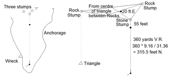
Unfortunately, I’m again prohibited from explaining all this as it’s been declared off topic. However, hopefully, you’ll be able to appreciate that the map appears to show how the instructions work from the illustration below.

360 yards V.R. NORTH 3 stumps: 55 feet from centre of triangle betwixt Rocks 20 feet E.

PalmerPlot.gif


I’ve really no wish to hang around here waiting for the insults and abuse that this post is sure to engender. It’s already been described as nonsense, baloney and crankery. However, I’m just hoping that some posters here can actually be objective and have an open mind on the subject.

Perhaps investigation should begin with what the instructions mean and then look to which island they might apply.
 

Attachments

  • PalmerPlot.gif
    PalmerPlot.gif
    15.2 KB · Views: 87
You may already know this.
Longitude and Latitude has changed since the 1700's

There was no universal standard back then.
Spanish measurements were different than English and Dutch.
I'm not sure of the exact year it became standardized.
But it may change your location slightly.
 
Latitude and longitude measurements have not changed geographically since the 18th century. They represent a fixed coordinate system on Earth. However, the accuracy of determining latitude and longitude, particularly for longitude, has significantly improved since that time. While the Earth's rotation and orbit are constantly changing on a geological timescale, these changes are minuscule over the span of a few centuries and do not affect the established coordinate system used today.


Here's a more detailed explanation:
Coordinate System:

Latitude and longitude form a grid system on the Earth's surface. Latitude lines (parallels) run east-west, and longitude lines (meridians) run north-south. These lines are fixed and define locations on the Earth's surface.

Accuracy of Measurement:

In the 18th century, determining longitude at sea was a major challenge due to the difficulty of keeping accurate time while on a moving ship. Latitude, however, was relatively easier to determine using the North Star.

Technological Advancements:

The invention of accurate marine chronometers, like John Harrison's H4, in themid-18th century, allowed for the precise measurement of longitude at sea. Modern GPS technology provides even greater accuracy in determining both latitude and longitude.

No Geographic Change:

While the technology for measurement has advanced dramatically, the actual geographic locations of latitude and longitude lines have not changed since the 18th century. The Earth's rotation and orbit, which define the coordinate system, are incredibly stable over such a short period.
 
Interesting theory Mr Bath.
 
If these calculations are correct and applied to Juan Fernandes island, aka Robinson Crusoe island, then that would place these points within the settlement there. if the points exist at all.
 
I have previously refrained from commentating on the longitude and latitude on the Skeleton Map but here are my thoughts.

1777383411655.webp

The Latitude is 9.16° N. The longitude is either 3.30° E or 31.30° E or 9.16° N, 431.30° E:

9.16° N, 3.30° E - Nigeria.
9.16° N, 31.30° E - South Sudan.
9.16° N, 43.30° E - Ethiopia
9.16° N, 431.30° E - meaningless/nowhere.

In Treasure Island, as part of Captain Flint's ledger (from Billy Bones' chest) there are the following coordinates:

The next ten or twelve pages were filled with a curious series of entries. There was a date at one end of the line and at the other a sum of money, as in common account-books; but instead of explanatory writing, only a varying number of crosses between the two. On the 12th of June, 1745, for instance, a sum of seventy pounds had plainly become due to some one, and there was nothing but six crosses to explain the cause. In a few cases, to be sure, the name of a place would be added, as "Offe Caraccas;" or a mere entry of latitude and longitude, as "62° 17' 20", 19° 2' 40".
We are not specifically told whether the latitude is N or S or longitude E or W, but it can be inferred N and E since numerical values without a North/South or East/West indicator are assumed to be positive; this means the coordinates are: 62° 17' 20 N, 19° 2' 40 E (Gulf of Bothnia, near Sweden). If not, and the coordinates are 62° 17' 20 S, 19° 2' 40 E, this points to an equally misleading location close to Antarctica. It is apparent that both the coordinates on the Skeleton Map and in Treasure Island are intentionally misleading or even meaningless. They point to locations in Nigeria/Sudan/Ethiopia/Nowhere and the Gulf of Bothnia or Antarctica. Both Gjb (2013, p. 71) and CapnGeorge in their books touch upon the Skeleton Map as evidently having been drawn in the vein of the map in Robert Louis Stevenson's Treasure Island (1883) or at least inspired by that map (this is something I have also long pointed out). CapnGeorge in Ansons's Gold (2016, p. 229) noted the Skeleton Map has "Anchorage" written on it and Stevenson wrote "Ay, here it is: Capt Kidd's Anchorage". He understands the individual who drew the Skeleton Map "got more inspiration from that book [Treasure Island]". The problem is Gjb/CapnGeorge both overlooked or ignored the coordinates in Treasure Island. Furthermore, at the beginning of the book, Hawkins explicitly states that he has omitted bearings to the island because there is "still treasure not yet lifted". The fact the Skeleton Map has misleading or meaningless coordinates (Nigeria/South Sudan/Ethiopia or Nowhere) follows the coordinates from Flint's ledger in Treasure Island. This is the simplest explanation (Occam's razor) and it is the tentatively correct answer or solution, unless someone can show otherwise.

There is no island at the coordinates 9.16° N, 3.30° E (Nigeria), 9.16° N, 31.30° E (South Sudan) or 9.16° N, 43.30° (Ethiopia) but it has been previously suggested by others [I could be mistaken, but I think first by Richard Knight] that the coordinates are 9.16° N, 131.30° E (Phillippine Sea). However, this is incorrect as there is not a 1 before the 3.

Admittedly, there is a number before the 3 but it is clearly not a 1:

1777397073923.webp

This does not look like a ÷ (division symbol) [contra Gjb] but it does look like a 4:

9.16° N, 431.30° E

A longitude of 431.30° E is not a standard coordinate but meaningless. However, this was intentional. The coordinates were written to deliberately point to nowhere if not misleadingly to Nigeria/South Sudan/Ethiopia, similar to how the coordinates from Flint's ledger in Treasure Island point to near Sweden or Antarctica.

Many other writers have come up with all sorts of explanations but they all have a preconceived location idea where the island is and then mess around with the coordinates and twist the facts to match that location. As an example, Graham Harris (2013) wrote:

The most important aspect of the fourth chart is, of course, the reference to latitude and longitude. There is no dispute about the latitude, it is plainly given as 9-16N, which is interpreted as 9E 16N North. The reference to longitude, on the other hand, is open to a number of interpretations; variously +31.30E, 431.30E or 43.30E for there may be a broken “4" preceding the figures which since it looks more like a “+” sign is confusing, perhaps intentionally so. The figure of 431.30E is meaningless and is promptly discounted. Mariners of the seventeenth century had no means of measuring their longitude by reference to a meridian such as Greenwich, however they would track their voyage by making reference to the last point of their departure. Numerous examples of this can be quoted from ships' logs of the period, Dampier and Narbrough being notable contemporaries of Kidd who consistently advocated this practice. Thus, it is reasoned, the longitude quoted on the fourth of the Kidd-Palmer charts must represent the departure, i.e. difference in longitude, from the pirate base of St. Marie from which Kidd sailed after he had accumulated some worthwhile treasure. The longitude of the pirate base at St. Marie is 49E 52N E of the Greenwich meridian, thus the island on the Kidd- Palmer charts is variously 49E 52N E + 31E 30N = 81E 22N E (which is close to Mullativu on the northeast coast of Ceylon), or 49E 52N E + 43E 30N = 93E 22N E (which is slightly north by a few sea miles of Car Nicobar in the Nicobars). Car Nicobar is an isolated island off the beaten track of vessels plying the trade routes between India and the East Indies. Many of the topographical features shown on the Kidd-Palmer charts can be identified on Car Nicobar.
By this method of where Kidd sailed and using a meridian as a point of departure, you can produce many different coordinates for the island. CapnGeorge's method is similarly as arbitrary (quite frankly ridiculous) and by playing around with numbers he ended up with the location of Pinaki, an atoll in French Polynesia. :tard: The coordinates do not match anywhere near Oak Island, so Gjb is left with arguing the coordinates do not involve a "longitude at all." All these type of "solutions" look to me like fallacious ad hoc hypotheses.
 
Last edited:
I have previously refrained from commentating on the longitude and latitude on the Skeleton Map but here are my thoughts.

View attachment 2251912
The Latitude is 9.16° N. The longitude is either 3.30° E or 31.30° E or 9.16° N, 431.30° E:

9.16° N, 3.30° E - Nigeria.
9.16° N, 31.30° E - South Sudan.
9.16° N, 43.30° E - Ethiopia
9.16° N, 431.30° E - meaningless/nowhere.

In Treasure Island, as part of Captain Flint's ledger (from Billy Bones' chest) there are the following coordinates:


We are not specifically told whether the latitude is N or S or longitude E or W, but it can be inferred N and E since numerical values without a North/South or East/West indicator are assumed to be positive; this means the coordinates are: 62° 17' 20 N, 19° 2' 40 E (Gulf of Bothnia, near Sweden). If not, and the coordinates are 62° 17' 20 S, 19° 2' 40 E, this points to an equally misleading location close to Antarctica. It is apparent that both the coordinates on the Skeleton Map and in Treasure Island are intentionally misleading or even meaningless. They point to locations in Nigeria/Sudan/Ethiopia/Nowhere and the Gulf of Bothnia or Antarctica. Both Gjb (2013, p. 71) and CapnGeorge in their books touch upon the Skeleton Map as evidently having been drawn in the vein of the map in Robert Louis Stevenson's Treasure Island (1883) or at least inspired by that map (this is something I have also long pointed out). CapnGeorge in Ansons's Gold (2016, p. 229) noted the Skeleton Map has "Anchorage" written on it and Stevenson wrote "Ay, here it is: Capt Kidd's Anchorage". He understands the individual who drew the Skeleton Map "got more inspiration from that book [Treasure Island]". The problem is Gjb/CapnGeorge both overlooked or ignored the coordinates in Treasure Island. Furthermore, at the beginning of the book, Hawkins explicitly states that he has omitted bearings to the island because there is "still treasure not yet lifted". The fact the Skeleton Map has misleading or meaningless coordinates (Nigeria/South Sudan/Ethiopia or Nowhere) follows the coordinates from Flint's ledger in Treasure Island. This is the simplest explanation (Occam's razor) and it is the tentatively correct answer or solution, unless someone can show otherwise.

There is no island at the coordinates 9.16° N, 3.30° E (Nigeria), 9.16° N, 31.30° E (South Sudan) or 9.16° N, 43.30° (Ethiopia) but it has been previously suggested by others [I could be mistaken, but I think first by Richard Knight] that the coordinates are 9.16° N, 131.30° E (Phillippine Sea). However, this is incorrect as there is not a 1 before the 3.

Admittedly, there is a number before the 3 but it is clearly not a 1:

View attachment 2251953
This does not look like a ÷ (division symbol) [contra Gjb] but it does look like a 4:

9.16° N, 431.30° E

A longitude of 431.30° E is not a standard coordinate but meaningless. However, this was intentional. The coordinates were written to deliberately point to nowhere if not misleadingly to Nigeria/South Sudan/Ethiopia, similar to how the coordinates from Flint's ledger in Treasure Island point to near Sweden or Antarctica.

Many other writers have come up with all sorts of explanations but they all have a preconceived location idea where the island is and then mess around with the coordinates and twist the facts to match that location. As an example, Graham Harris (2013) wrote:


By this method of where Kidd sailed and using a meridian as a point of departure, you can produce many different coordinates for the island. CapnGeorge's method is similarly as arbitrary (quite frankly ridiculous) and by playing around with numbers he ended up with the location of Pinaki, an atoll in French Polynesia. :tard: The coordinates do not match anywhere near Oak Island, so Gjb is left with arguing the coordinates do not involve a "longitude at all." All these type of "solutions" look to me like fallacious ad hoc hypotheses.
My guess is that the coordinates are as plain as the rest of the map. Whoever created them for whatever reason. Those coordinates will be authentic and I think everyone will feel stupid not having thought of the solution that was in plain sight. The whole thing seem to me done by someone who makes fun of those who try to over-complicate everything. Thinking of secret codes and misdirection etc.

There is certainly a connection to Treasure Island. It could be that the map creator took its hints from the book. It could also be it was the other way around.

Stephenson didn't invent everything. Same as most fiction writers there is a great amount of fact in the fiction. I actually think it is sourced from one or more of the expeditions that went after the Avery treasure. Those tales would have been told in the inns for many years after (what else is there to speak about). In the antique times there was no separation of fact from fiction. Take the Odyssey. I found in my voyages that there is quite an interesting amount of navigational facts and history in the tale. Who ever has sailed the med for a while knows that quite suddenly a strong gale can push you far away from where you intended to go. So maybe it is good to read the tales again.

Btw there is another solution to the longitude but I will stop here because I fear some stupid people will read it here and spoil another paradise.
 
My guess is that the coordinates are as plain as the rest of the map. Whoever created them for whatever reason. Those coordinates will be authentic and I think everyone will feel stupid not having thought of the solution that was in plain sight. The whole thing seem to me done by someone who makes fun of those who try to over-complicate everything. Thinking of secret codes and misdirection etc.

There is certainly a connection to Treasure Island. It could be that the map creator took its hints from the book. It could also be it was the other way around.

Stephenson didn't invent everything. Same as most fiction writers there is a great amount of fact in the fiction. I actually think it is sourced from one or more of the expeditions that went after the Avery treasure. Those tales would have been told in the inns for many years after (what else is there to speak about). In the antique times there was no separation of fact from fiction. Take the Odyssey. I found in my voyages that there is quite an interesting amount of navigational facts and history in the tale. Who ever has sailed the med for a while knows that quite suddenly a strong gale can push you far away from where you intended to go. So maybe it is good to read the tales again.

Btw there is another solution to the longitude but I will stop here because I fear some stupid people will read it here and spoil another paradise.

9.16° N, 431.30° E

Longitude does not extend 431.30° East or West. From Google:

1777662498230.webp

The most straightforward and simplest explanation is the meaningless longitude was intentional to give an imaginary location.
 
Personally, I see nothing constructive in trying to make sense of coordinates given from a map that has been conclusively proven to be a fake. It is more an exercise of wishful thinking. Thinking about it is as meaningless as trying to flog a dead horse.

There are many more compelling and real treasures out there to seek. Diamonds, rubies, sapphires and emeralds. a four inches piece once adorn Mogul nobility. about 4 inches long.

q2.webp


q3.webp


q4.webp


q5.webp

It was once laced with natural pearls, as was the style of the day.

But you will not find treasure like this consulting 20th treasure hunting book authors or by the Palmer maps that flog the dream and not the reality.

It takes years of dedicated research, and even then, there are no guarantees of treasure.

Crow
 
Last edited:
This is truly unbelievable! You’re all fully prepared to consider ‘what are the consequences of assuming that this is not a division sign’, but you outright refuse to assess what might be the consequences were it actually a division sign.

The intent of the exercise was to consider whether the latitude and longitude might not be a lat-long at all, but your response is to refuse outright to consider this a possibility and thereby to see where this might lead. It’s almost as if none of you has ever wondered whether what you’ve decided is true might actually be false, and that you’ve also never wondered what might be revealed should you ever care to acknowledge that you could actually be wrong about something.

We’re presumably here wanting to explore possibilities, to be thinking and reasoning about the subject, and hopefully at some stage in the distant future we might actually start doing so. However, based on the above reactions, I won’t be holding my breath!
 
1777721149006.webp


4 ÷

Why would it be a division sign?
The bottom is quite clearly a 4 and you can see part of the faded ink on the left hand side closing the gap:

1777721367798.webp


1777721472472.webp


1777721612492.webp
 
Those coordinates will be authentic and I think everyone will feel stupid not having thought of the solution that was in plain sight.
If the coordinates are not imaginary (9.16° N, 431.30° E) it might be argued to subtract 360 degrees from the longitude:

1777725882120.webp


So 431.30° E - 360 = 71.30°

= 9.16° N, 71.30° E

Is this what you had in mind?

1777726041819.webp


The coordinates are closest to the island Minicoy (aka Maliku) but a considerable distance.

The island is a crescent shape with a lagoon.

1777726158518.webp


1777728348511.webp


Compare to the Coral Island Map and Skeleton Map:

1777726418779.webp


1777726377768.webp


This site has probably already (erroneously) been suggested as the island on the Kidd-Palmer maps (including Skeleton Map) by someone, furthermore, it is possibly Randawg72's. Although Minicoy (aka Maliku) matches the general shape of the island depicted on the Kidd-Palmer maps and it notably has a lagoon, little else matches. For example, there were five famous ships that crashed off the coast of Minicoy in its shallow reefs: SS Colombo (1862), SS Thrunscoe (1899), Duffryn Manor (1909), SS Delagoa (1910), and the Tolna (1900) but these wrecks are located on the opposite side of the island to what is pinpointed on the Skeleton Map (compare above to below). If you look at one of the Kidd-Palmer maps (Coral Island Map), there are hills and elevation. However, Minicoy Island (Maliku) does not have any natural hills. As a coral atoll, it is flat with a very low elevation, averaging just 1 meter above sea level. Minicoy was never a pirate haven.

1777726971868.webp


If Minicoy is identified as the Island depicted on the Kidd-Palmer maps then you have to ignore many features on the latter and this involves an element of personal whim or judicious selection. Similarly, CapnGeorge ignores the many discrepancies between Pinaki Atoll and the island depicted on the Kidd-Palmer maps. By this approach, you can identify dozens or even hundreds of different islands as the Kidd-Palmer island. How many crescent-shaped islands are there with lagoons?

1777730380780.webp
 
Last edited:
I know this really isn’t going to go down well at all! I’m going to suggest that the Skeleton Map may be a poor copy of a previous map rather than simply being itself faded. That is, it may well have been copied from a faded original.

I’m going to have a shot at the unintelligible text in the right-hand margin, suggesting that it may not be what it seems simply because it has been misunderstood by a transcriber, perhaps due to fading of the original, and the copier not recognising it for what it is. We have:

Skelon.gif


This is presumably the origin of Wilkins’ name ‘Skeleton Island’ although in an unpublished typescript he suggests that the first word is ‘stakes’ (hence his ‘Stakes in Lake’).

However, although nobody here likes the idea, I have suggested that the text V.R in the left margin may be an abbreviation of Vmbra Recta from the Shadow Scale of the astrolabe and thus signifying the trigonometric co-tangent or tangent. This would then require the application of a trigonometric ratio in the form of a ÷ b, hence suggesting that the lat-long might be just that: 9.16 ÷ 31.36.

My suggestion is that just as V.R. may be Latin, the unintelligible text may be Greek and perhaps conveys the same thing. Note that the second letter of the final ‘Lε6’ is actually a Greek epsilon. Significantly, then, the strange word ‘skelev’ might be ‘skelwv’ or such: perhaps σκελών from σκέλος in this case meaning ‘of the sides’ (literally ‘legs’ of a triangle).

If the text be Greek then the second word ‘of’ preceded by a gap may well be the concluding ‘ος’ of the subject noun. Thence, the ‘Lε6’ might be the first three letters ‘γεω’ (Geo) perhaps from γεωμετρικός meaning ‘geometric’.

Should this be an alternative expression of Vmbra Recta then the missing word is likely to be λόγος or ‘logos’ meaning in this context ‘ratio’. Hence, the original may have read, ‘the geometric ratio of the sides (of a triangle)’, perhaps: σκελών λόγος γεωμετρικός but perhaps taking the Western form resulting in 'skelwv' or 'skelon'.

The definite article is sometimes omitted in Classical Greek such as λόγου ὰποτομή, a work by Apollonius referenced by Pappus.

So, perhaps the copier of the maps was presented with ‘skelwv oς γεω’ with only half of the concluding letter omega due to fading. He therefore took his best shot: 'skelev of Lε6'. So, maybe this could be evidence of a copy of a faded original rather than itself being necessarily faded. Thus, the text may have been a clue as to the meaning of V.R., if not also of the lat-long, but became garbled.

I appreciate that this simply can’t be correct because nobody here will want it to be, but I introduce it for consideration nonetheless, despite knowing the reaction, because I believe that this is an enquiry and this is what people do when they’re inquiring into puzzling topics.

So, feel free to provide the actual and definitive answer to what this text really is or means. I don’t insist that what I say has be right, just as I don’t declare that everybody else must be wrong.
 
Last edited:
The only unambiguous letters are "of" and the first word begins with an "S".

S... of [something].

It looks to me that the first word is Stele which explains the following:

1778087367247.webp


This resembles a pillar/stele symbol (Irminsul [Old Saxon 'Great Pillar']):

1778087471036.webp

1778087530279.webp

1778087491821.webp


A stele is a marker which also matches the other text on the border of the map i.e., rocks as markers.

1778087999247.webp

Stele (marker symbol) + of ...

This is far more straightforward compared to what you are claiming.
 
The only unambiguous letters are "of" and the first word begins with an "S".

S... of [something].

It looks to me that the first word is Stele which explains the following:

View attachment 2252757

This resembles a pillar/stele symbol (Irminsul [Old Saxon 'Great Pillar']):

View attachment 2252758
View attachment 2252760
View attachment 2252759

A stele is a marker which also matches the other text on the border of the map i.e., rocks as markers.

View attachment 2252761
Stele (marker symbol) + of ...

This is far more straightforward compared to what you are claiming.
So, what exactly are you saying? What about the remaining text? What follows if you're right?

My suggestion ties in exactly with the rocks as markers (the 'stumps'), and actually explains how to get to them and how to use them. I'm suggesting that you can't separate the Coral Island Map from the Skeleton Map. They work together.
 
Last edited:
I'm of the opinion, clearly not subscribed to here, that one should not necessarily expect everything on a treasure map to be all it seems. It would appear that the general feeling here is that anybody compiling a treasure map would be completely truthful and open concerning everything it shows.

Above all, there would be no possibility of subterfuge, because why would anyone want to disguise the route to their treasure? Why would they want to ensure that their treasure went only to the owner or designated heir? Why would they ever want to incorporate clues that only the intended recipient would understand?

So, one might expect the instructions provided to be cryptic, unlike with the open map of Treasure Island, but would expect them eventually to be meaningful if found in their original form.

Furthermore, why might somebody copying a treasure map not make alterations that only they would therefore know about, in order to put others off the scent? Why might they not also superimpose their particular thoughts upon it?

We seem to be caught up in a concept here that everything written, everything published, is necessarily true. Historians would challenge this. They would attempt to get into and behind what’s written, to assess possible motives, to track down inconsistencies.

Apparently, here, if a potential treasure map says it’s on an island in the China Sea then that’s where it is, if it says text is a lat-long then it can’t be anything else. We don’t even know for sure if the outline of the island is the right one. All we can do is hope that the interior pointers and the instructions are correct.

In this case, the island could be anywhere in the world, and Captain Kidd need not have buried treasure upon it. However, if we can identify the right island then the clues should start making sense.

So, maybe to get the right island we should be looking at the clues, the instructions and the content, as indicators instead of poring over maps of the Far East and sticking pins in them.
 
Last edited:
If the coordinates are not imaginary (9.16° N, 431.30° E) it might be argued to subtract 360 degrees from the longitude:

View attachment 2252306

So 431.30° E - 360 = 71.30°

= 9.16° N, 71.30° E

Is this what you had in mind?
No it isn't and it would also be another of the endless tries to take something simple and turn it into something complex. There is no reason other than no one found the place to suspect something sophisticated like encodings and willful misdirection. I do not know about that treasure but I think that island exists at least as the inspiration of the one who draw the map. And from what I know he is a navigator.

So there is no reason that within some margin of error there should be huge differences from the drawing to the real thing. Complex geometry, encodings, number play, etc only serve to fit the facts to the ideas not the other way around.

Our problem with those maps is not that the message is complicated but that the receiver (we) live in a changed world where the symbols have a changed meaning and that makes it very difficult to understand the message. The only way to understand it is to change the context.
 
I'm of the opinion, clearly not subscribed to here, that one should not necessarily expect everything on a treasure map to be all it seems. It would appear that the general feeling here is that anybody compiling a treasure map would be completely truthful and open concerning everything it shows.

Above all, there would be no possibility of subterfuge, because why would anyone want to disguise the route to their treasure? Why would they want to ensure that their treasure went only to the owner or designated heir? Why would they ever want to incorporate clues that only the intended recipient would understand?

So, one might expect the instructions provided to be cryptic, unlike with the open map of Treasure Island, but would expect them eventually to be meaningful if found in their original form.

Furthermore, why might somebody copying a treasure map not make alterations that only they would therefore know about, in order to put others off the scent? Why might they not also superimpose their particular thoughts upon it?

We seem to be caught up in a concept here that everything written, everything published, is necessarily true. Historians would challenge this. They would attempt to get into and behind what’s written, to assess possible motives, to track down inconsistencies.

Apparently, here, if a potential treasure map says it’s on an island in the China Sea then that’s where it is, if it says text is a lat-long then it can’t be anything else. We don’t even know for sure if the outline of the island is the right one. All we can do is hope that the interior pointers and the instructions are correct.

In this case, the island could be anywhere in the world, and Captain Kidd need not have buried treasure upon it. However, if we can identify the right island then the clues should start making sense.

So, maybe to get the right island we should be looking at the clues, the instructions and the content, as indicators instead of poring over maps of the Far East and sticking pins in them.
Yes it will be in the China Sea alright. Only what we mean with China Sea might be something very different then what the author meant by it. It is also a possibility that by copying those maps (I doubt that what we see are original or even close copies) the phonetics have been projected into different spellings. It could be something similar sounding. Chinese whispers come into the mind (what a coincidence LoL).
 
I know this really isn’t going to go down well at all! I’m going to suggest that the Skeleton Map may be a poor copy of a previous map rather than simply being itself faded. That is, it may well have been copied from a faded original.
I assumed since quite while that what we see are copies of copies,
I’m going to have a shot at the unintelligible text in the right-hand margin, suggesting that it may not be what it seems simply because it has been misunderstood by a transcriber, perhaps due to fading of the original, and the copier not recognising it for what it is. We have:

View attachment 2252698

This is presumably the origin of Wilkins’ name ‘Skeleton Island’ although in an unpublished typescript he suggests that the first word is ‘stakes’ (hence his ‘Stakes in Lake’).

However, although nobody here likes the idea, I have suggested that the text V.R in the left margin may be an abbreviation of Vmbra Recta from the Shadow Scale of the astrolabe and thus signifying the trigonometric co-tangent or tangent. This would then require the application of a trigonometric ratio in the form of a ÷ b, hence suggesting that the lat-long might be just that: 9.16 ÷ 31.36.

My suggestion is that just as V.R. may be Latin, the unintelligible text may be Greek and perhaps conveys the same thing. Note that the second letter of the final ‘Lε6’ is actually a Greek epsilon. Significantly, then, the strange word ‘skelev’ might be ‘skelwv’ or such: perhaps σκελών from σκέλος in this case meaning ‘of the sides’ (literally ‘legs’ of a triangle).

If the text be Greek then the second word ‘of’ preceded by a gap may well be the concluding ‘ος’ of the subject noun. Thence, the ‘Lε6’ might be the first three letters ‘γεω’ (Geo) perhaps from γεωμετρικός meaning ‘geometric’.

Should this be an alternative expression of Vmbra Recta then the missing word is likely to be λόγος or ‘logos’ meaning in this context ‘ratio’. Hence, the original may have read, ‘the geometric ratio of the sides (of a triangle)’, perhaps: σκελών λόγος γεωμετρικός but perhaps taking the Western form resulting in 'skelwv' or 'skelon'.

The definite article is sometimes omitted in Classical Greek such as λόγου ὰποτομή, a work by Apollonius referenced by Pappus.

So, perhaps the copier of the maps was presented with ‘skelwv oς γεω’ with only half of the concluding letter omega due to fading. He therefore took his best shot: 'skelev of Lε6'. So, maybe this could be evidence of a copy of a faded original rather than itself being necessarily faded. Thus, the text may have been a clue as to the meaning of V.R., if not also of the lat-long, but became garbled.

I appreciate that this simply can’t be correct because nobody here will want it to be, but I introduce it for consideration nonetheless, despite knowing the reaction, because I believe that this is an enquiry and this is what people do when they’re inquiring into puzzling topics.

So, feel free to provide the actual and definitive answer to what this text really is or means. I don’t insist that what I say has be right, just as I don’t declare that everybody else must be wrong.
A lot of ideas. V.R. is a clear nautical term as is the dead-reckoning route. I do not know why this is ever disputed.

I doubt that any Latin or Greek is used but maybe you are right. But why not using Hebrew (Leb: Heart, will, mind) as well. I haven't found any other language where the word makes any sense.

The idea that some information is scrambled by copying from a original is valid I think. At least I see it as more valid than the ideas which include misdirection's, encodings, trigonometry etc.

Another point is the 'e' in Leb it seems very differently written then the others on the maps. in fact its upper part seems not to come from an 'e' at all.
 
I found out what V.R. on the map most probably is - V.R. stands for "Variation" or "Variation of the Needle":

1778518023984.webp


1778518184170.webp


1778518532215.webp
 

Users who are viewing this thread

Back
Top Bottom