gjb
Sr. Member
- #21
Thread Owner
Sorry to trouble you with this nonsense, but I’m continuing to sell things off and thought I might share a few things before they disappear.
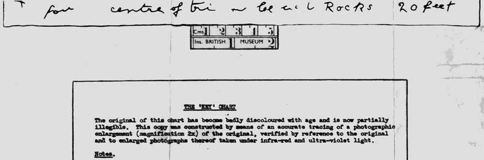
Cryptid will assure us that the above is fake because people at the Map Library at the British Library have declared in writing that they have no knowledge of it, so it has to be fake. I have plenty of letters to this effect, therefore what they say has to be factual. Thus, the above never happened.
Even R.A. Skelton wrote that he didn’t know about it. I even produced it at the Map Room when this was in the British Museum (tucked away off a landing). They had no knowledge of it. So, it can’t possibly exist and I apologise for troubling you with an obvious fake. However, since I clearly have no shame, I’ll reproduce the rest of it:
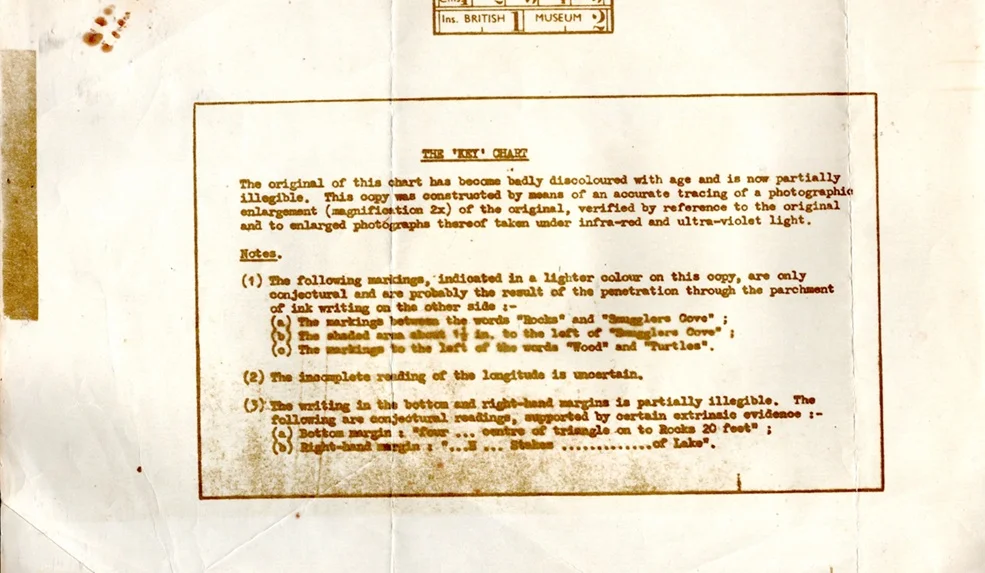
Now, Cryptid will be able to reassure us that it definitely has to be fake. After all, it’s saying that the chart is badly discoloured and we know that’s not true: we have the images. They’re totally clean, that is, except for the sham on the cover of Furneaux’s book.
It also has to be fake because you’ll appreciate from the fake BM scale bar that the map measures 11.7 inches by 8.2 inches. However, the text does say that it’s at magnification x 2 so they’re trying to pass it off as the real thing by suggesting that you have to divide these measurements by the square root of two, thus getting 8.3 x 5.8 inches. Now, that’s cunning.
What’s also cunning is that Skelton and others reported that the chart had been taken to be examined by infra-red and ultra-violet light, and this fake very cleverly says the same thing. However, it does say that this is an accurate tracing of the original so it can’t be as good as the images we have which are all of the real thing. So, this is clearly of no use at all.
I suppose that the faker is trying to suggest that while the chart was being checked out by infra-red and ultra-violet light somebody took a photograph that Skelton and the others knew nothing about. However, if they didn’t know about it, and therefore didn’t tell anyone about it, then we can be sure that it never happened. Indeed, that’s exactly what the Map Library people are saying.
So, we can discount all the nonsense these notes are telling us, particularly that, “the incomplete reading of the longitude is uncertain.” Of course it’s certain, everyone here is saying so, and we definitely know better than the faker trying to pass this off as the real thing.
You’ll also see the suggestion that the odd text in the right margin might read, “Stakes ... of Lake”, which that total buffoon Harold Wilkins frequently reports this as saying. Since he can’t possibly have seen these notes, or know about the assessment, we can be absolutely sure that it’s a fake.
Finally, I make a distinction between the two real versions of the map. There’s the Edmunds version and then there’s the Furneaux version. This one is the Furneaux version. Oddly enough, the cover of Furneaux’s book shows the Edmunds version while the plate inside is the Furneaux version. Very confusing.
However, we can safely discount all of this because what we’re seeing here is an obvious forgery. Just ask Cryptid! Believe what's written, particularly everything people say in writing, because everything they write has to be fact (that is, when it’s convenient)!
Cryptid will assure us that the above is fake because people at the Map Library at the British Library have declared in writing that they have no knowledge of it, so it has to be fake. I have plenty of letters to this effect, therefore what they say has to be factual. Thus, the above never happened.
Even R.A. Skelton wrote that he didn’t know about it. I even produced it at the Map Room when this was in the British Museum (tucked away off a landing). They had no knowledge of it. So, it can’t possibly exist and I apologise for troubling you with an obvious fake. However, since I clearly have no shame, I’ll reproduce the rest of it:
Now, Cryptid will be able to reassure us that it definitely has to be fake. After all, it’s saying that the chart is badly discoloured and we know that’s not true: we have the images. They’re totally clean, that is, except for the sham on the cover of Furneaux’s book.
It also has to be fake because you’ll appreciate from the fake BM scale bar that the map measures 11.7 inches by 8.2 inches. However, the text does say that it’s at magnification x 2 so they’re trying to pass it off as the real thing by suggesting that you have to divide these measurements by the square root of two, thus getting 8.3 x 5.8 inches. Now, that’s cunning.
What’s also cunning is that Skelton and others reported that the chart had been taken to be examined by infra-red and ultra-violet light, and this fake very cleverly says the same thing. However, it does say that this is an accurate tracing of the original so it can’t be as good as the images we have which are all of the real thing. So, this is clearly of no use at all.
I suppose that the faker is trying to suggest that while the chart was being checked out by infra-red and ultra-violet light somebody took a photograph that Skelton and the others knew nothing about. However, if they didn’t know about it, and therefore didn’t tell anyone about it, then we can be sure that it never happened. Indeed, that’s exactly what the Map Library people are saying.
So, we can discount all the nonsense these notes are telling us, particularly that, “the incomplete reading of the longitude is uncertain.” Of course it’s certain, everyone here is saying so, and we definitely know better than the faker trying to pass this off as the real thing.
You’ll also see the suggestion that the odd text in the right margin might read, “Stakes ... of Lake”, which that total buffoon Harold Wilkins frequently reports this as saying. Since he can’t possibly have seen these notes, or know about the assessment, we can be absolutely sure that it’s a fake.
Finally, I make a distinction between the two real versions of the map. There’s the Edmunds version and then there’s the Furneaux version. This one is the Furneaux version. Oddly enough, the cover of Furneaux’s book shows the Edmunds version while the plate inside is the Furneaux version. Very confusing.
However, we can safely discount all of this because what we’re seeing here is an obvious forgery. Just ask Cryptid! Believe what's written, particularly everything people say in writing, because everything they write has to be fact (that is, when it’s convenient)!
Last edited: