signumops
Hero Member
- Feb 28, 2007
- 756
- 226
- Detector(s) used
- Garrett, Minelab, Aqua-Pulse
- Primary Interest:
- All Treasure Hunting
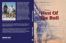
"West Of The Bull" is now available at Amazon. 254 pages, 60+ maps, 80+ photos, 25 pages of document images, fully indexed. Many photos are 40 or more years old, so not all of them are great, but the maps are sharp, for the most part.
The scoop:
Prior to the acquisition of properties on Cape Canaveral and Merritt Island by the federal government for the Air Force Eastern Test Range and the Kennedy Space Center, residents in the vicinity were aware of the many shipwrecks along the coast from Edgewater southward to present-day Port Canaveral, an area now known in Florida as the Space Coast. As the Kennedy Space Center was being developed, a number of treasure hunters combed the area, making remarkable finds dating from ancient times throughout the first contact period between Florida natives and Europeans. Before the creation of the Canaveral National Seashore and the Merritt Island National Wildlife Refuge, some of these treasure hunters managed salvage leases all along the Cape Canaveral area, awarded to them by the State of Florida. This is the story of one such venture, the New Channel Historical Survey Group’s Exploratory Lease E5A. T. L. Armstrong and Randy Andrews worked for the New Channel Historical Survey Group, headed up by Bill and Florence Andrews. E5A was situated along the southern extent of Klondike Beach, perhaps so named for the booty found there in the past.
West Of The Bull contains many previously unpublished treasure recovery maps of the area produced by Bill Andrews, Lou Ullian, and Robert F. Marx, as well as a number of aerial charts especially prepared by the author. Personal notes of Robert F. Marx dealing with shipwrecks around the Cape are included, along with a summary of archaeological sites recorded by George A. Long for NASA in 1965.
The Look Inside feature is available at the Amazon listing page.