somehiker
Silver Member
- Joined
- May 1, 2007
- Messages
- 4,388
- Reaction score
- 6,443
- Golden Thread
- 0
- Primary Interest:
- All Treasure Hunting
Tim I knew if I sent that map to Wayne you guys would end up hanging off that cliff again.
Wayne stay out of that hole. It a place Canadians go an never come out.
I can't help but wonder what did the map maker see on that Texas trip so many years ago.
You know how much I like climbing up or dangling over them cliffs. But this hole is at the base of one.
It looks a little different than when I first spotted it though. Originally had a bunch of rocks blocking it up.
Bob Garmin, who made that map, also had this translated waybill ....
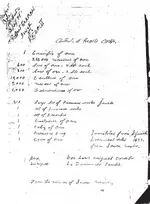
Way too much to fit in THAT hole, but I suspect is what the Tumlinsons were looking for.
View attachment waybills.bmp
Last edited:


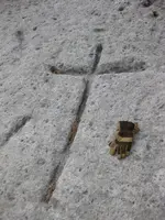
 . Seriously though, I have a difficult time seeing most of the things people post photos of here that they consider to be "markers." Now and then one pops up that strikes me, and this one is obviously one of those. Good job finding that one Wayne/Vastterrain!! I'd say unless someone decided as a "prank" in the last 50 years or so to chisel that into the rock, you're onto something interesting to say the least!