What's new

Did someone say Ice Holes?

chalkoutline

Hero Member
Joined
Apr 1, 2025
Messages
679
Reaction score
279
Golden Thread
0
When I heard there were Ice Holes found off the South Cove, I had to ask Google AI a few questions:

Question 1: Who found three ice holes off shore on oak island?
Answer: Dan Blankenship discovered the mysterious ice holes off the South Shore of Oak Island, first observing them in March 1979. These four, equally-spaced, non-freezing holes in the ice were interpreted as evidence of a, subterranean flood tunnel connecting to the treasure-hunting area. He spotted them again in 1980.

Question 2: What is the cause of ice holes off shore on oak island found by dan Blankenship?
Answer: The ice holes discovered by Dan Blankenship in 1979/1980 off the South Shore of Oak Island are believed to be caused by warm water upwelling from suspected underground man-made flood tunnels or chambers. They are theorized to be connected to the "Money Pit" treasure, potentially indicating offshore flood tunnels

Question 3: How far offshore were the ice holes found by Dan Blankenship
Answer: In February 1980, Dan Blankenship discovered four circular, equidistant ice holes approximately 700 feet off the South Shore Cove of Oak Island. These holes, which appeared again in 1987, were believed to be evidence of a man-made, deep-water flood tunnel system connecting to the island's Money Pit.

Question 4: How would someone dig flood tunnels from the island ending 700ft offshore of oak island?
Answer: Digging theoretical flood tunnels from Oak Island to 700ft offshore involves historical mining techniques: sinking a main vertical shaft (Money Pit), digging downward-sloping tunnels, and likely USING COFFER DAMS OR WORKING AT LOW TIDE to prevent seawater intrusion during construction. These tunnels, roughly 2.5 ft by 4 ft, would likely be backfilled with coconut fiber and rocks to filter water, according to www.oakislandmystery.com and Reddit users.

Question 5: Were the ice holes found by dan Blankenship offshore of south cove on oak island
Answer: Yes, Dan Blankenship and the Triton team identified multiple holes in the ice, often referred to as "ice holes" or "ice vents," in the frozen waters of Mahone Bay off the south shore of Oak Island, near Smith's Cove, during the winters of 1979 and 1981

Question 6: How far from the Money Pit to South cove?
Answer: Based on maps and surveys of Oak Island, the shortest straight-line distance from the Money Pit area on the eastern side of the island to the nearest point at South Cove is approximately 300 to 400 feet (about 90–120 meters).

Question 7: How far from the Money Pit to Smith's cove?
Answer: Based on historical explorations of the Oak Island Money Pit and Smith's Cove:
Distance: The, "Money Pit" is located approximately 460 feet (roughly 140 meters) from the flood tunnels at Smith's Cove.

Question 8: How deep is the water 700ft from south cove on oak island?
Answer: Based on geological surveys and maritime data regarding the area surrounding Oak Island, Nova Scotia, the water depth 700 feet from the South Shore Cove is relatively shallow, generally fitting within the context of a 50-foot maximum depth for the deeper sections immediately surrounding the island.
 
When I heard there were Ice Holes found off the South Cove, I had to ask Google AI a few questions:

Question 1: Who found three ice holes off shore on oak island?
Answer: Dan Blankenship discovered the mysterious ice holes off the South Shore of Oak Island, first observing them in March 1979. These four, equally-spaced, non-freezing holes in the ice were interpreted as evidence of a, subterranean flood tunnel connecting to the treasure-hunting area. He spotted them again in 1980.

Question 2: What is the cause of ice holes off shore on oak island found by dan Blankenship?
Answer: The ice holes discovered by Dan Blankenship in 1979/1980 off the South Shore of Oak Island are believed to be caused by warm water upwelling from suspected underground man-made flood tunnels or chambers. They are theorized to be connected to the "Money Pit" treasure, potentially indicating offshore flood tunnels

Question 3: How far offshore were the ice holes found by Dan Blankenship
Answer: In February 1980, Dan Blankenship discovered four circular, equidistant ice holes approximately 700 feet off the South Shore Cove of Oak Island. These holes, which appeared again in 1987, were believed to be evidence of a man-made, deep-water flood tunnel system connecting to the island's Money Pit.

Question 4: How would someone dig flood tunnels from the island ending 700ft offshore of oak island?
Answer: Digging theoretical flood tunnels from Oak Island to 700ft offshore involves historical mining techniques: sinking a main vertical shaft (Money Pit), digging downward-sloping tunnels, and likely USING COFFER DAMS OR WORKING AT LOW TIDE to prevent seawater intrusion during construction. These tunnels, roughly 2.5 ft by 4 ft, would likely be backfilled with coconut fiber and rocks to filter water, according to www.oakislandmystery.com and Reddit users.

Question 5: Were the ice holes found by dan Blankenship offshore of south cove on oak island
Answer: Yes, Dan Blankenship and the Triton team identified multiple holes in the ice, often referred to as "ice holes" or "ice vents," in the frozen waters of Mahone Bay off the south shore of Oak Island, near Smith's Cove, during the winters of 1979 and 1981

Question 6: How far from the Money Pit to South cove?
Answer: Based on maps and surveys of Oak Island, the shortest straight-line distance from the Money Pit area on the eastern side of the island to the nearest point at South Cove is approximately 300 to 400 feet (about 90–120 meters).

Question 7: How far from the Money Pit to Smith's cove?
Answer: Based on historical explorations of the Oak Island Money Pit and Smith's Cove:
Distance: The, "Money Pit" is located approximately 460 feet (roughly 140 meters) from the flood tunnels at Smith's Cove.

Question 8: How deep is the water 700ft from south cove on oak island?
Answer: Based on geological surveys and maritime data regarding the area surrounding Oak Island, Nova Scotia, the water depth 700 feet from the South Shore Cove is relatively shallow, generally fitting within the context of a 50-foot maximum depth for the deeper sections immediately surrounding the island.
My Takeaways

Question 9:
how far does the tide go out at south cove on oak island
Answer: Based on recent NOAA data for the area, tidal ranges in the vicinity of Oak Island typically see low tides falling to approximately -0.3 to −0.6 feet below mean lower low water (MLLW).

This Rules out digging the tunnels at low tide

Question 10
: is it possible to build a coffer dam in 50ft of water depth 700ft from shore in 1600s
Answer: Building a cofferdam in 50ft (approx. 15 meters) of water, 700ft from shore, in the 1600s was extremely unlikely to be feasible with the technology available at the time. While cofferdam technology existed (piles driven into mud, filled with clay), its application was historically limited to much shallower, calmer waters, typically under 15–20 feet, to allow for the construction of bridge piers.

This rules out using a coffer dam 700ft out in 50ft deep water
 
My Takeaways

Question 9:
how far does the tide go out at south cove on oak island
Answer: Based on recent NOAA data for the area, tidal ranges in the vicinity of Oak Island typically see low tides falling to approximately -0.3 to −0.6 feet below mean lower low water (MLLW).

This Rules out digging the tunnels at low tide

Question 10
: is it possible to build a coffer dam in 50ft of water depth 700ft from shore in 1600s
Answer: Building a cofferdam in 50ft (approx. 15 meters) of water, 700ft from shore, in the 1600s was extremely unlikely to be feasible with the technology available at the time. While cofferdam technology existed (piles driven into mud, filled with clay), its application was historically limited to much shallower, calmer waters, typically under 15–20 feet, to allow for the construction of bridge piers.

This rules out using a coffer dam 700ft out in 50ft deep water

Even counting the supposed 8 feet of sea level rise in the area (I don't know where that datum was sourced, but I think it's referenced in Sullivan's book and elsewhere) since ye olden days, ~42 feet minus low tide is still a crazy deep spot for any workings prior to the industrial revolution.

But caveat: you are using AI to refute AI.

In the context of Oak Island, we are sort of trained up to think of cofferdams as a bulwark against the (high tide) sea with a seaward facing side and a shoreward facing side, but cofferdams can also be completely enclosed, i.e. a rectangular or circular construct with a dry inside, once the water is pumped/bailed out. How such differs from a caisson, I'm not sure ... maybe they are effectively the same at that point. The process for sinking the components into a river-bed was apparently described as far back as Vitruvius in first century BCE [De Architectura]. The sea is not a river, but perhaps these methods can be scaled up for different depths, given enough resources and motivation. Some of the groups attached to these O.I. legends were supposed to be master builders, after all, with the complete wisdom of the East and West at their disposal.

--GT
 
Even counting the supposed 8 feet of sea level rise in the area (I don't know where that datum was sourced, but I think it's referenced in Sullivan's book and elsewhere) since ye olden days, ~42 feet minus low tide is still a crazy deep spot for any workings prior to the industrial revolution.

But caveat: you are using AI to refute AI.

In the context of Oak Island, we are sort of trained up to think of cofferdams as a bulwark against the (high tide) sea with a seaward facing side and a shoreward facing side, but cofferdams can also be completely enclosed, i.e. a rectangular or circular construct with a dry inside, once the water is pumped/bailed out. How such differs from a caisson, I'm not sure ... maybe they are effectively the same at that point. The process for sinking the components into a river-bed was apparently described as far back as Vitruvius in first century BCE [De Architectura]. The sea is not a river, but perhaps these methods can be scaled up for different depths, given enough resources and motivation. Some of the groups attached to these O.I. legends were supposed to be master builders, after all, with the complete wisdom of the East and West at their disposal.

--GT
GT,
All good points.
Im not suggesting Google AI is 100% accurate and knows everything there is. However, it makes me think, ask questions and draw my own conclusions rather than take a story at face value.

With regards to the cofferdams, i was still watching COOI when they built the cofferdam at Smith's cove and they had a lot of trouble with it. So the idea that flood tunnels were dug 700ft off shore in 50ft of water in four different places is simply not plausible for the 1600/1700s.

I do agree the cofferdams would have been circular in nature.
-CO
 
GT,
All good points.
Im not suggesting Google AI is 100% accurate and knows everything there is. However, it makes me think, ask questions and draw my own conclusions rather than take a story at face value.

With regards to the cofferdams, i was still watching COOI when they built the cofferdam at Smith's cove and they had a lot of trouble with it. So the idea that flood tunnels were dug 700ft off shore in 50ft of water in four different places is simply not plausible for the 1600/1700s.

I do agree the cofferdams would have been circular in nature.
-CO
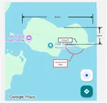
Im still trying to put the ice holes into perspective so i attached a diagram which shows a a RED circumference where the ice holes were seen 700ft off the shore.

This would have meant the depositors dug 460ft from the Money Pit to the shore and then dug tunnels 700ft off shore under the ocean: 1160ft in total.

Google AI indicated Smith's Cove is the same as the South Shore and why i put the circumference off Smith's Cove. Please correct me if Google AI is wrong.

This raises the question... if there were box/finger drains at Smith's Cove, why would you need tunnels 700ft off shore.?
 

Attachments

  • Ice Holes.webp
    Ice Holes.webp
    42.1 KB · Views: 79
The ice holes can also be explained by the permeable limestone bedrock which, amazingly, can explain the initial indentation in the ground, the soft soil, the rocks and logs found, and the tendency to flood no matter where you dig. It fully meets the Occam's Razor criterion but takes all the fun out of pretending there is buried treasure.
 
believed to be caused by warm water upwelling from suspected underground man-made flood tunnels or chambers.
Google AI seems to think the ice holes were caused by warm water from flood tunnels BUT if the tunnels are 50ft below the surface, wouldn't the warm water mix with the cold Atlantic and actually too cold to melt the surface ice?

Just how hot would the water coming out of the tunnels actually have to be to create an ice hole?
 
if the tunnels are 50ft below the surface, wouldn't the warm water mix with the cold Atlantic and actually too cold to melt the surface ice?

Yeah, that's a tall column to keep unmixed to the surface. If convection currents work in water like they do in air, I guess we would assume the warm water rises, displacing colder water to the sides? If there were a warm(er) source coming from seabed, similar to a Florida spring, maybe instead of melting ice, it simply kept it from freezing in the first place?

But, why would it be warm? If it's been deep underground in the island's strata during winter, how much of a temperature differential could there possibly be? And why would water be emerging from a hole in the seabed if it was attached to a tunnel? Even if a tunnel angled down from island to sea, wouldn't the ambient water line inside the tunnel stay at tide level regardless? There would be inflow and outflow as the tides moved, not a one-directional flow. Then again I'm not sure why springs emerge from the Florida aquifer either, so I guess I need tutelage in geologic fluid mechanics.

--GT
 
Yeah, that's a tall column to keep unmixed to the surface. If convection currents work in water like they do in air, I guess we would assume the warm water rises, displacing colder water to the sides? If there were a warm(er) source coming from seabed, similar to a Florida spring, maybe instead of melting ice, it simply kept it from freezing in the first place?

But, why would it be warm? If it's been deep underground in the island's strata during winter, how much of a temperature differential could there possibly be? And why would water be emerging from a hole in the seabed if it was attached to a tunnel? Even if a tunnel angled down from island to sea, wouldn't the ambient water line inside the tunnel stay at tide level regardless? There would be inflow and outflow as the tides moved, not a one-directional flow. Then again I'm not sure why springs emerge from the Florida aquifer either, so I guess I need tutelage in geologic fluid mechanics.

--GT
Hi GravelTeeth, if you recall I explained to you how the inlets were blasted up from from the end of each tunnel that came from under the South Shore beach near the Detour Road air vents. When that explosion happened the sea immediately rushed down to the bottom of the Money Pit sand sump, it washed down beech stones, sand, and sea shells.
The sea water gradually rose up to reached a stagnant level, this was in the West bound tunnel and its rise was stopped by a designed air lock. Sea bed sand was constantly entering down through the outlets with the tide movements, this in turn caused escaping air bubbles to constantly rise to the surface, this perpetually effect kept the ice holes from freezing over.

Oak Island Sage
 
this perpetually effect kept the ice holes from freezing over.
OIS,
How do you know it isn't just polynyas?

Yes, polynyas (openings in sea ice) can form 700 feet off the coast of Nova Scotia in 50-foot deep water, though they are more frequently called coastal polynyas or ice leads i
 
Google AI indicated Smith's Cove is the same as the South Shore and why i put the circumference off Smith's Cove. Please correct me if Google AI is wrong.
Thaks to the schematic provided by OI Sage, i realized the South Shore and Smith's Cove are not the same so i updated my drawing where Dan Blankenship saw the ice holes 700ft off the South Shore.

Since i don't know the exact location, i estimate the aleged depositors dug four tunnels 500ft to 1000ft from the MP to the South Shore before digging 700ft out into Mahone Bay.

It could be as much as 2000ft to 2500ft to get to the South Shore location since it is not a straight line but rather head west and then down to South Shore . Then add 700ft off shore
 

Attachments

  • Ice Holes2.webp
    Ice Holes2.webp
    42.7 KB · Views: 64
Last edited:

Users who are viewing this thread

Back
Top Bottom