Dutchman's Caches

OP
OP
Idahodutch

Idahodutch

Bronze Member
Sep 25, 2019
1,850
4,786
Idaho
Detector(s) used
Whites MXT
Gold Legend
Primary Interest:
Other
I accidently posted the following on the wrong thread, fixing now,

I see it as important to follow clues as much as possible. You can never tell when a clue will pop out at you. In this case, it is WHICH mouth of canyon, Waltz was talking about. But now is evident it was the mouth of the ravine drainage.

A snip from the directions from Brownie Holmes Manuscript:

“Go through this saddle and on up a low ridge and when you get to the highest point of the ridge you can look north and the four peaks are lined up to look like one peak.
In the other direction you will see a high needle.

In the canyon under you is my hidden camp.
You can't get down there because it's too steep, go to the mouth of the canyon and then back.

You can find the rock house with very little difficulty. You won't be able to see it until you are right upon it. After you find the camp then come back out of the canyon. (Here Waltz gave a direction to the mine that Holmes and Roberts kept secret). You will never be able to find the mine until you first find the rock house as the shaft is completely hidden. A prospector won't find it because there is no ledge in view. In the mine you will find about $75,000 dollars in gold already dug out. There is enough gold left to dig to make twenty men millionaires." I dug the outcropping away and erased all signs of my digging.“

Good Morning and Happy Sunday to everybody.
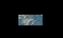
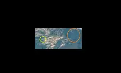
after close examination of the outcropping, no more than 200' directly across from the hidden camp (see Bicknell's article),
it is my opinion that the outcropping in the image below is the elusive LDM.

- Holmes Manuscript identifies the location of the hidden camp from a confirmation point above, as being up the canyon from the mouth of the drainage canyon below the special viewing spot of Four Peaks, as one peak.
- Bicknell's article says the mine is no more than 200' directly across from the rock house. The article also indirectly says there must be a place up above the mine that contains the shaft mine (the one Waltz got from Peralta, see Bicknell's article).
There is definitely a match up above this outcropping fitting the description of area of the shaft mine.

The Exact spot for the shaft mine up above is not confirmed, but we can at least take a look at this outcropping.

Camp + 186'.jpg

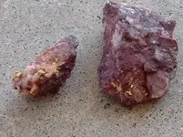
You all help me decide ..... would Harnish have left that outcropping like we see it today, or would it look different if he had investigated it?
I leaning to maybe he missed it all together .... :headbang:
 

Last edited:
OP
OP
Idahodutch

Idahodutch

Bronze Member
Sep 25, 2019
1,850
4,786
Idaho
Detector(s) used
Whites MXT
Gold Legend
Primary Interest:
Other
I have been struggling a bit, mentally ...
Maybe psyched out some about that ravine.
I have not had my a$$ kicked that severely... since I don’t know when.
I got to look at the hidden camp, and got to look at the outcrop mine.
I had no business trying to hike around that ravine, in the condition I was in.
I was being very careful, but still got bunged up. Lots of slipping of feet, catclaw type brush .... really sucks :)

I have to admit, I want to make another trip, but I need to get my head right. I underestimated or conveniently forgot the degree of physical drain that hiking around terrain like that, can have.

Then there are realities like logistics of actually getting into one of the mines; the outcrop mine, that is across from the hidden camp, or the inclined shaft mine up above the outcrop mine.

Both have severe challenges ..... first, is it is a wilderness area.
Second are the physical landscape obstacles. Severe is good descriptive from a young guy, in shape ... but for an older guy, past his prime ..... well I am trying to get psyched up for it, but sorting through it.

I’ve been catching myself staring off .... just trying to sort thoughts I guess ;)
I can already feel the oxygen .... so looks like all things permitting, another trip for the fall.

The race is still on :)
(As long as mosey speed counts)
 

skyhawk1251

Sr. Member
Nov 9, 2018
312
669
Kingman, AZ
Detector(s) used
Fisher Gold Bug Pro
Primary Interest:
Prospecting
I found two areas on the slopes of Palomino Mountain that I found to be of interest to me, if only from a geological standpoint, but what I see could also indicate some human activity in the past. Idahodutch, and others, might find these areas of interest, too.

This GE image shows an area on the eastern slopes of Palomino Mountain. GPS coordinates are at the bottom of the image. Enclosed in the red box is a depression what what looks like a stacked-stone wall along its eastern/downslope edge. The "wall" might not actually be a "wall." Instead, it could be stones placed in orderly rows directly on the ground. By changing my viewing angle, I couldn't determine if the "wall" has any significant height above ground, nor could I determine if the "wall" deviated much from the overall angle of the slope. What is more "artificial" looking are the stones inside the depression, and spaced along its northern edge, almost as if they were moved aside as excavating was in progress.

001.png

This GE image shows an area on the western slopes of Palomino Mountain that also could show evidence of human activity in the past. The rubble pile within the larger red box could be natural, or it could be a prospect/mine dump. There could be shafts within both red boxes; the resolution of the images is too poor to say for sure.

002.png

Finally, here is a zoomed view of Idahodutch's "Camp" image. At the "camp" (left, red box), I clearly see stonework meeting at a 90-degree angle; this indicates human activity at that location. The "outcrop" (right, red box) is not what I would expect an outcrop to look like, but the lack of vegetation there is very strange. I do have to admit, however, that I've seen similar rock fields that lack any brush here in the Cerbat Mountains.

004.png

"I got to look at the hidden camp, and got to look at the outcrop mine. I have to admit, I want to make another trip ...

... looks like all things permitting, another trip for the fall." -- Idahodutch
 

OP
OP
Idahodutch

Idahodutch

Bronze Member
Sep 25, 2019
1,850
4,786
Idaho
Detector(s) used
Whites MXT
Gold Legend
Primary Interest:
Other
I found two areas on the slopes of Palomino Mountain that I found to be of interest to me, if only from a geological standpoint, but what I see could also indicate some human activity in the past. Idahodutch, and others, might find these areas of interest, too.

This GE image shows an area on the eastern slopes of Palomino Mountain. GPS coordinates are at the bottom of the image. Enclosed in the red box is a depression what what looks like a stacked-stone wall along its eastern/downslope edge. The "wall" might not actually be a "wall." Instead, it could be stones placed in orderly rows directly on the ground. By changing my viewing angle, I couldn't determine if the "wall" has any significant height above ground, nor could I determine if the "wall" deviated much from the overall angle of the slope. What is more "artificial" looking are the stones inside the depression, and spaced along its northern edge, almost as if they were moved aside as excavating was in progress.

View attachment 1926838

This GE image shows an area on the western slopes of Palomino Mountain that also could show evidence of human activity in the past. The rubble pile within the larger red box could be natural, or it could be a prospect/mine dump. There could be shafts within both red boxes; the resolution of the images is too poor to say for sure.

View attachment 1926839

Finally, here is a zoomed view of Idahodutch's "Camp" image. At the "camp" (left, red box), I clearly see stonework meeting at a 90-degree angle; this indicates human activity at that location. The "outcrop" (right, red box) is not what I would expect an outcrop to look like, but the lack of vegetation there is very strange. I do have to admit, however, that I've seen similar rock fields that lack any brush here in the Cerbat Mountains.

View attachment 1926840

"I got to look at the hidden camp, and got to look at the outcrop mine. I have to admit, I want to make another trip ...

... looks like all things permitting, another trip for the fall." -- Idahodutch

Skyhawk,
Thanks for posting, feedback is good to have.
On the spot I believe to be Waltz’s hidden camp, there is some visible stone work in what’s left of the shallow cave, stacked, right angles etc, but mud/dirt slides long ago filled the majority of that space.
There is more stone work just outside that, a crude retaining Wall that allows that flat looking grassy spot to be there.

That outcrop, I have been thinking about.
There is a definite break point, where the natural outcrop has been removed, dug down, and filled back with large rocks/small boulders. That big pile of large rocks/small boulders, is considerably big. About 40’ x 40’ area at least. The slope of the ravine in that area is right at the line between hiking and climbing.

I would say that most of those rocks were part of the outcrop, with maybe a few, carefully managed down from above, to finish off Waltz’s concealment of their work.

Palomino has had lots of activity.
It would be interesting to find out how those operations fared out.
At one time, some believed they had found the LDM on the west face.

I am sorry that I do have more pictures.

I will tell you this, there were symbols used on an unpopular map, for showing the general location of the outcrop mine. The same symbols can be seen boots to the ground, on that outcrop site. They are not as easily recognizable in that larger red box you made, but can still be seen somewhat.

It is that same unpopular map, that was pointing to the spot of Alleged Waltz’ hidden camp. It’s what made me look at it to begin with.
It is the same map that indicates something Non-gold was moved out of the outcrop mine, to a short distance away, begging the question about weiser’s gravesite.
I didn’t get a chance to investigate all the various areas of interest. We were only investigating for part of a day. Energy depleted long before daylight. :laughing7:

There are things that definitely still need to be checked out. In my opinion :)
I’m a little nervous about it.
 

OP
OP
Idahodutch

Idahodutch

Bronze Member
Sep 25, 2019
1,850
4,786
Idaho
Detector(s) used
Whites MXT
Gold Legend
Primary Interest:
Other
I’m just a old kid, that grew up hearing about LDM, and had a good friend, whose dad was an avid Dutch hunter.
Like all of us at one time or another, thought about finding it.

It’s more than a hobby, it’s challenging, dangerous, cowboy and Indian stuff ...
exciting to partake, and the ol’ “maybe one day”.

For me, that one day .. could be the next trip, and I have concern about being able to do it.
This legend is pretty big deal .. I’m a old broken down construction worker. I’m not a miner, or an excavator. I don’t know how much good either of those skills would get in a wilderness area...
I’m just nervous, I’ll get my head right.. I hope :)

The upper mine, the incline shaft ... supposedly the one with famous white quartz ore ...
That one as far as I know, is not covered up, except by brush, and/or trees ... way up in corner almost.
If that was located and was open, I believe legal samples could be acquired...

If me or someone else locates it, there is good possibility of there being evidence of what actually transpired in the earliest part of LDM lore.

Bones and/or bullets.
Just saying, the rest of Bicks 1895 story leading up to that ravine, seem accurate enough... maybe the remaining parts are as well. :dontknow:
 

skyhawk1251

Sr. Member
Nov 9, 2018
312
669
Kingman, AZ
Detector(s) used
Fisher Gold Bug Pro
Primary Interest:
Prospecting
Here are GE images of Idahodutch's "ravine" and "camp." The zoomed screenshots are the best that I can obtain -- resolution is poor. The wide-angle view locates the "ravine" among the surrounding peaks. See the bottom of the images for GPS coordinates.

005.png

In the image below, the "camp" is enclosed in the red box.

004.png

In this last image please inspect what is shown in the left, red box. I see what look like overlapping timbers, but I can't believe what I'm seeing is really there. Some opinions would be welcome. The "camp" is shown in the right, red box. It's in a very difficult to reach spot. Looks like approaching it from below or above would be a formidable task, but I'd rather climb up to it, then continue up and over to leave it.

009.png
 

OP
OP
Idahodutch

Idahodutch

Bronze Member
Sep 25, 2019
1,850
4,786
Idaho
Detector(s) used
Whites MXT
Gold Legend
Primary Interest:
Other
Skyhawk,
On this last trip, we entered the ravine from the west, and was already at mid-ravine elevation upon entering it.
I traversed directly across, over to the outcrop first, then on over to the camp location. Then returned the same way.
The clue for locating the camp, says to enter from the mouth of the drainage wash below, and that you would not see the camp until almost come upon it.
That was the original plan we had, but ended up camping in Boulder Canyon, instead of below the ravine.
Matthew Roberts said he went up in that ravine, he went up from the mouth of the drainage wash, along the wash, on his way up to saddle, where he exited.

On this trip, I didn’t go to the saddle, but did 12 years ago, I climbed up from the north end of the saddle. I would have just nipped the upper right hand corner of the left red box, of the 3rd image above of your post.
I honestly don’t recall anything peculiar about that, but the high point of the north end of the saddle was obstructing my view of stuff just north of it .... where you speak of possible timbers.
I also had lots of sweat pouring down my face, and in my eyes, and was really out of breath. Where your gums hurt, type of out of breath.
On my way back down, I pretty much went same as way up.

There could be something there, or could be rock .... GE can mess with rock formations.
The low ridge behind the ravine, looks very different in person.
The Rock formations associated with the ravine in Boulder canyon, just north of Needle Canyon, also look very different in person. I almost did not recognize the entrance to Needle Canyon ... in person. But the last time I was at that junction, I wasn’t even a teenager yet :)
 

Last edited:

skyhawk1251

Sr. Member
Nov 9, 2018
312
669
Kingman, AZ
Detector(s) used
Fisher Gold Bug Pro
Primary Interest:
Prospecting
A tip of my hat and a salute of respect to anyone who attempts navigating this ravine. The difficulty of doing so cannot be minimized. Too much brush and rock-hopping for me. Two local peaks are on my to-do list, but thick brush and boulders could stop me on the lower slopes. A recent hike toward Thimble Butte from Cool Springs, AZ came to an abrupt end when I saw a solid wall of cholla cactus blocking my way. Being scratched, bloodied, and impaled by cactus spines is not my idea of fun in the sun.
 

Cubfan64

Silver Member
Feb 13, 2006
2,986
2,789
New Hampshire - USA
Detector(s) used
Fisher CZ21, Teknetics T2 & Minelab Sovereign GT
Primary Interest:
All Treasure Hunting
A tip of my hat and a salute of respect to anyone who attempts navigating this ravine. The difficulty of doing so cannot be minimized. Too much brush and rock-hopping for me. Two local peaks are on my to-do list, but thick brush and boulders could stop me on the lower slopes. A recent hike toward Thimble Butte from Cool Springs, AZ came to an abrupt end when I saw a solid wall of cholla cactus blocking my way. Being scratched, bloodied, and impaled by cactus spines is not my idea of fun in the sun.

Ahhh but that's where the good stuff is cause nobody else wanted to go through to see what was on the other side either :)
 

coazon de oro

Bronze Member
May 7, 2010
1,624
3,859
texas
Primary Interest:
All Treasure Hunting
A tip of my hat and a salute of respect to anyone who attempts navigating this ravine. The difficulty of doing so cannot be minimized. Too much brush and rock-hopping for me. Two local peaks are on my to-do list, but thick brush and boulders could stop me on the lower slopes. A recent hike toward Thimble Butte from Cool Springs, AZ came to an abrupt end when I saw a solid wall of cholla cactus blocking my way. Being scratched, bloodied, and impaled by cactus spines is not my idea of fun in the sun.

Howdy skyhawk,

Just get a "vaqueiro" outfit, they dress with leather from head to toe. They plow at full gallop through brush and cactus chasing cattle to catch them by hand. If this video loads up, one hits a cactus at around 2:00.
 

markmar

Silver Member
Oct 17, 2012
4,119
6,260
Primary Interest:
All Treasure Hunting
Idahodutch

One important clue of the LDM outcrop, is someone can't approach it from above or from below, but only from the side. Another clue is the place was barren and Waltz planted a Juniper to hide the mine. The only vegetation was above the small valley where the mines were located.
Here is a crop of a real picture, which shows the small valley. In the yellow circle are the landmarks depicted in " Waltz " map, and the LDM inclined shaft ( red dot ) is in the trench between the elongated rock and the triangle. In the orange oval is the " face " depicted in the Perfil mapa, and above the inclined shaft location and to the left of the" sphinx ", on the cliff's wall, you can see the alabaster cross that Celeste Marie Jones was looking for.

attachment.php
attachment.php
attachment.php
 

Attachments

  • LDM.jpg
    LDM.jpg
    11 KB · Views: 332
  • LDM 2.jpg
    LDM 2.jpg
    13.2 KB · Views: 337
  • pic.jpg
    pic.jpg
    1.2 KB · Views: 509
Last edited:

skyhawk1251

Sr. Member
Nov 9, 2018
312
669
Kingman, AZ
Detector(s) used
Fisher Gold Bug Pro
Primary Interest:
Prospecting
Valley -- "A low area of land between hills or mountains, typically with a river or stream flowing through it."

Ledge -- "A narrow horizontal surface projecting from a wall, cliff, or other surface."

Definitions from Oxford Languages.

In this image, I see a ledge, not a valley. In the arid SW, disregard, "typically with a river or stream flowing through it."

LDM.jpg
 

OP
OP
Idahodutch

Idahodutch

Bronze Member
Sep 25, 2019
1,850
4,786
Idaho
Detector(s) used
Whites MXT
Gold Legend
Primary Interest:
Other
Idahodutch

One important clue of the LDM outcrop, is someone can't approach it from above or from below, but only from the side. Another clue is the place was barren and Waltz planted a Juniper to hide the mine. The only vegetation was above the small valley where the mines were located.
Here is a crop of a real picture, which shows the small valley. In the yellow circle are the landmarks depicted in " Waltz " map, and the LDM inclined shaft ( red dot ) is in the trench between the elongated rock and the triangle. In the orange oval is the " face " depicted in the Perfil mapa, and above the inclined shaft location and to the left of the" sphinx ", on the cliff's wall, you can see the alabaster cross that Celeste Marie Jones was looking for.

attachment.php
attachment.php
attachment.php

Markmar,
Thanks for sharing your thoughts. Are you thinking of joining the race?
:occasion14:
 

Doc4261

Hero Member
Nov 5, 2015
582
578
Primary Interest:
All Treasure Hunting
Idahodutch

One important clue of the LDM outcrop, is someone can't approach it from above or from below, but only from the side. Another clue is the place was barren and Waltz planted a Juniper to hide the mine. The only vegetation was above the small valley where the mines were located.
Here is a crop of a real picture, which shows the small valley. In the yellow circle are the landmarks depicted in " Waltz " map, and the LDM inclined shaft ( red dot ) is in the trench between the elongated rock and the triangle. In the orange oval is the " face " depicted in the Perfil mapa, and above the inclined shaft location and to the left of the" sphinx ", on the cliff's wall, you can see the alabaster cross that Celeste Marie Jones was looking for.

attachment.php
attachment.php
attachment.php

This is the perfil map area. It's not where you are talking about. Map is actually 3D. Got to bend it at the middle creek ravine. My question has anyone that already knows this been there? Not what I'm looking for , so no I haven't spent the time to.climb there myself tho. Even if this is one of the easiest to get to of all the maps of mines in th sups. Perfil map is Not of the Ldm.. In the giving mood today, for those that don't know of the area yet.
FB_IMG_1622120310518.jpg FB_IMG_1622120288814.jpg FB_IMG_1622120305094.jpg
 

Last edited:

skyhawk1251

Sr. Member
Nov 9, 2018
312
669
Kingman, AZ
Detector(s) used
Fisher Gold Bug Pro
Primary Interest:
Prospecting
"I traversed directly across, over to the outcrop first ..." -- Idahodutch

I was up in the Cerbat Mountains Monday, 5/24/21, and spotted two, clearly defined dykes. The dykes are mineralized, but apparently only contain iron, and do not contain ores of valuable metals, such as gold or silver. If they did contain gold or silver ores, I would call them outcrops, rather than dykes.

This first photo shows a dyke running down a hillside (inside larger, red box). A prospector, long ago, dug into, and alongside, the dyke, (smaller, red box) but found nothing of value, since the dyke is mostly untouched. The mine dump to the left in the photo is from other mining activity nearby.

IMG_2338.JPG

This second photo shows a very narrow dyke at an old mine site. The miner/miners at this site had very poor mining knowledge. I doubt if this mine ever produced any valuable ore, and probably never amounted to more than a money-wasting prospect. The dyke is inside the red box.

IMG_2342.JPG

If anyone finds any outcrops of quartz with gold nuggets that can be pried out with a knife blade, quit your day job immediately, and stop buying lottery tickets. Your financial troubles will be at an end. Keep looking for that rich outcrop, but don't waste time on worthless dykes.
 

azdave35

Silver Member
Dec 19, 2008
3,606
8,104
"I traversed directly across, over to the outcrop first ..." -- Idahodutch

I was up in the Cerbat Mountains Monday, 5/24/21, and spotted two, clearly defined dykes. The dykes are mineralized, but apparently only contain iron, and do not contain ores of valuable metals, such as gold or silver. If they did contain gold or silver ores, I would call them outcrops, rather than dykes.

This first photo shows a dyke running down a hillside (inside larger, red box). A prospector, long ago, dug into, and alongside, the dyke, (smaller, red box) but found nothing of value, since the dyke is mostly untouched. The mine dump to the left in the photo is from other mining activity nearby.

attachment.php


This second photo shows a very narrow dyke at an old mine site. The miner/miners at this site had very poor mining knowledge. I doubt if this mine ever produced any valuable ore, and probably never amounted to more than a money-wasting prospect. The dyke is inside the red box.

attachment.php


If anyone finds any outcrops of quartz with gold nuggets that can be pried out with a knife blade, quit your day job immediately, and stop buying lottery tickets. Your financial troubles will be at an end. Keep looking for that rich outcrop, but don't waste time on worthless dykes.
just because the dyke doesn't carry precious metal doesn't mean they are worthless....there are other valuable minerals that were mined years ago such as lead..zinc..iron...tungsten ..etc..during ww2 all gold and silver mines were deemed useless to the war effort and shut down.....but other minerals were were heavily mined...iron and lead especially...and if you ignore iron and lead mines you will be passing up gold...here are specimens from an iron mine in arizona

attachment.php
 

Attachments

  • goldd.jpg
    goldd.jpg
    36.2 KB · Views: 578

skyhawk1251

Sr. Member
Nov 9, 2018
312
669
Kingman, AZ
Detector(s) used
Fisher Gold Bug Pro
Primary Interest:
Prospecting
True, azdave35. The dykes in my photos are apparently "worthless", relatively speaking, because they were abandoned fairly fast by prospectors/miners. You're absolutely on target, however, that some iron-rich dykes can contain useful metals, such as lead and zinc. The major producers around Chloride, AZ provided abundant amounts of lead and zinc, in addition to silver ore. Thanks for posting the additional information.
 

Gregory E. Davis

Sr. Member
Oct 22, 2013
332
1,003
Tempe, Arizona
Detector(s) used
eyeball it
Primary Interest:
All Treasure Hunting
Hello Doc4261, Interesting picture. Do you have another showing the area further to the left of the one you posted? Cordially, Gregory E. Davis
 

skyhawk1251

Sr. Member
Nov 9, 2018
312
669
Kingman, AZ
Detector(s) used
Fisher Gold Bug Pro
Primary Interest:
Prospecting
Could this --

LDM.jpg

be this?

012.png

Also, in the same canyon, the shadow of a "cima." GPS coordinates are at the bottom of the GE images.

015.png
 

markmar

Silver Member
Oct 17, 2012
4,119
6,260
Primary Interest:
All Treasure Hunting
Valley -- "A low area of land between hills or mountains, typically with a river or stream flowing through it."

Ledge -- "A narrow horizontal surface projecting from a wall, cliff, or other surface."

Definitions from Oxford Languages.

In this image, I see a ledge, not a valley. In the arid SW, disregard, "typically with a river or stream flowing through it."

attachment.php

"Small valley" were not my words, but Waltz's when described the area of the mine in one of his clues. What you see in the picture as a ledge, to the left of the "face", is about two acres large, so you can estimate the dimensions of the labdmarks around the mine. Also when is raining, through that plain is running a little stream,BTW.
 

Top Member Reactions

Users who are viewing this thread

Latest Discussions

Top