What's new

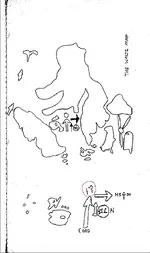
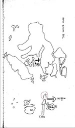
The Waltz Map

Don't worry, I won't go walk your coordinates and make a video....unless you and I discuss things before hand. lol. I'm not that kind of guy. "Your area" is "your area." I won't impose or anything like that. I'll actually make sure to stay away from that area until it's clear you are through.
Cuz,
I’ve been on here sharing my search for some time. Not many have responded.

The team is small, and getting older.
Our plan is to see how accurate the stories are, and …..

Our next trip is tentative for spring sometime.

I think it could be quite the time.
(You come highly recommended btw 👍)
What say you 🥸 ?

Sincerely,
Idahodutch
 
Cuz,
I’ve been on here sharing my search for some time. Not many have responded.

The team is small, and getting older.
Our plan is to see how accurate the stories are, and …..

Our next trip is tentative for spring sometime.

I think it could be quite the time.
(You come highly recommended btw 👍)
What say you 🥸 ?

Sincerely,
Idahodutch
Oh this is an easy one. I am 100% in.... Thank you for that.
And whoever gave me the vote of confidence, thank you too! :)
I do have one condition, however, if its okay.......
I'm not carrying any suitcases. :)
 
Oh this is an easy one. I am 100% in.... Thank you for that.
And whoever gave me the vote of confidence, thank you too! :)
I do have one condition, however, if its okay.......
I'm not carrying any suitcases. :)

No . You carry ALL the baggage after that bad joke!
 
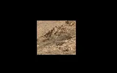
Don't forget to go to the left if you will see the "rock man". The real one
 

Attachments

  • rock man.webp
    rock man.webp
    12 KB · Views: 184
Oh this is an easy one. I am 100% in.... Thank you for that.
And whoever gave me the vote of confidence, thank you too! :)
I do have one condition, however, if its okay.......
I'm not carrying any suitcases. :)
No suitcases 👌😁
 
Good morning Stroker,
No matter where Waltz might have pointed, it is hard to think that there would Not be preparation for the trip, not just gear, water, but for information. Details about Waltz’ mine site. He said HAVE to find the hidden camp first.
Then says why ….. that his mine is not more than 200’ directly across the canyon. So the hidden camp is also used as a marker to measure from.
Details are lacking to locate the mine.

In Holmes manuscript, the directions instruct Holmes to get on the trail to San Carlos, after it turns to the south, to go left, when see the rock man. … then to a saddle.. finally up to a high point of the ridge ( above the hidden camp) to view 4- peaks as one peak. Those directions are details for finding stuff at the ravine.

I have not been to coffee flat, but if LDM is up there, it seems that there would be clues matching up. Can you share any of those?

Is there a ravine up there?
A saddle tying into a ridge?
If not those clues, there must be some clues matching up, I would think.

You have to admit, that if Waltz had previously made a map of the ravine, it would be a game changer ……. Pointing the way starts to become more believable … just saying 🙂

Idahodutch
A couple of reasons that lead me to believe that it could be up on Coffee are that there has been gold found there, Waltz has been seen around there and climbing up the north side, the doodle matches the view from there in my opinion, it`s close to Florence where he made a trip and back in a few days, you can see Four Peaks and the military trail all the way from Ft. Mc Dowell when the calvary was kicking up the dust, some of the stuff on the Stone maps.
 
A couple of reasons that lead me to believe that it could be up on Coffee are that there has been gold found there, Waltz has been seen around there and climbing up the north side, the doodle matches the view from there in my opinion, it`s close to Florence where he made a trip and back in a few days, you can see Four Peaks and the military trail all the way from Ft. Mc Dowell when the calvary was kicking up the dust, some of the stuff on the Stone maps.
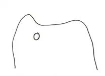
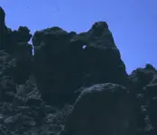
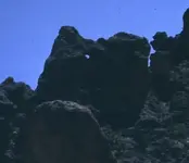
Speaking of the doodle..... Is this the doodle that looks like a rock with a hole in it? If so... Jim Hatt found a rock very similar to that doodle as well. Post #9 in this thread: https://www.treasurenet.com/threads/jim-hatts-cave.598245/
 
Speaking of the doodle..... Is this the doodle that looks like a rock with a hole in it? If so... Jim Hatt found a rock very similar to that doodle as well. Post #9 in this thread: https://www.treasurenet.com/threads/jim-hatts-cave.598245/
It gets even better when you look at the Waltz map and see the same rock shape (mirrored) with a hole in the same location on the Waltz map.

Not that I put a lot of faith in either, but there must be a connection between the maps creators.
 

Attachments

  • Untitled.webp
    Untitled.webp
    27.2 KB · Views: 141
It gets even better when you look at the Waltz map and see the same rock shape (mirrored) with a hole in the same location on the Waltz map.

Not that I put a lot of faith in either, but there must be a connection between the maps creators.
"Connection between the map creators..."
Very interesting.........
 
"Connection between the map creators..."
Very interesting.........
There are though, multiple rock formations that have a "hole" in it to some capacity out there...

-SpartanOC
 
There sure are, not many that im aware of (which isnt saying much) that match these 2 maps.

I dont put much stock in them either, for what its worth.
 

Attachments

  • Untitled.webp
    Untitled.webp
    27.2 KB · Views: 113
  • Waltz drawing Petrasch.webp
    Waltz drawing Petrasch.webp
    3.4 KB · Views: 96
  • Hatts Cave Rock Mirrored.webp
    Hatts Cave Rock Mirrored.webp
    11.4 KB · Views: 117
  • Hatts Cave Rock.webp
    Hatts Cave Rock.webp
    13.2 KB · Views: 119
It gets even better when you look at the Waltz map and see the same rock shape (mirrored) with a hole in the same location on the Waltz map.

Not that I put a lot of faith in either, but there must be a connection between the maps creators.
As I wrote, the " Waltz map " is a Mexican map, eventually made by the Peraltas in regards to describe the region close to the LDM inclined shaft. The Mexican-Spanish concept in making coded treasure maps, is to draw on the map shapes from the surrounding region, following rows of rocks and rock's outlines on the ground.
This is the concept for all the Spanish-Mexican coded treasure maps, without exception. If you want to find something using these maps , then you have to follow their rules. Nothing more and nothing less.
 

Attachments

  • Peralta-Waltz map.webp
    Peralta-Waltz map.webp
    153.5 KB · Views: 141
As I wrote in another post, from my own research on this subject, the Waltz's doodle from Helen Corbin's book, is an image of the place where the " gov trail goes south " from Holmes clues given by Waltz. The mountain to the left in the sketch, is not a mountain , it's a hill or the " low ridge " described in the same set of clues. So, the image it's a view from the north and describes the surrounding landmarks and the ravine west of that hill. Also it's for a small area, which can be recognized only if someone would be just north of that hill, at its base.
The peak in the image is Weavers Needle, but is not a real image of it. It was drew as a symbol of WN to be not confused with another peak, so don't take its image as an accurate clue.
The location of which the doodle was made for, it's just a point of reference in the trail to the LDM, to ensure they would be at the right place. The LDM it's not in sight in this sketch, but somewhere to the left from the hill.
 
Last edited:
As I wrote in another post, from my own research on this subject, the Waltz's doodle from Helen Corbin's book, is an image of the place where the " gov trail goes south " from Holmes clues given by Waltz. The mountain to the left in the sketch, is not a mountain , it's a hill or the " low ridge " described in the same set of clues. So, the image it's a view from the south and describes the surrounding landmarks and the ravine west of that hill. Also it's for a small area, which can be recognized only if someone would be just north of that hill, at its base.
The peak in the image is Weavers Needle, but is not a real image of it. It was drew as a symbol of WN to be not confused with another peak, so don't take its image as an accurate clue.
The location of which the doodle was made for, it's just a point of reference in the trail to the LDM, to ensure they would be at the right place. The LDM it's not in sight in this sketch, but somewhere to the left from the hill.
Well I plan on going up to the top of Coffee and have a look see, but I’m not gonna go up the way Robles’s saw Jacob going up.
 
Over a year has gone by, and there was some information I read recently (I think in the Bark Notes), that had to do with when Waltz was at his mine site….. and if Waltz made “the Waltz Map”, then it can be translated into when he might have made the map.

That is assuming that Waltz was looking at the site while he was making the map.

In the recent readings, it also said that Waltz had settled in Phoenix in 1868.

There supposedly was a statement by Waltz, saying that it had been 14 years; from when he was last at the site, when he had walled up his partner in his mine, to when he returned.

Then another statement where supposedly Waltz (nearing the final stage of his life) said it had been 8 years since he was there last.

In putting this info next to each other, a time line emerges …

I’m assuming that Waltz settled in Phoenix after he finished walling up his partner inside of the mine, and spending the winter, burying everything.

1868 + the 14 years when he first returns = 1882.

Then going backwards from when waltz said it had been 8 years since he was there.
He was giving Julia and Rhiney, information about his mine and how he got it, in the last months of his life…. Less than a year before he died is my assumption.

He died in 1891, and then backwards 8 years puts it back to 1883 that he was last there.

*** Also there is some time to add on site, for Waltz making the map.

I’m thinking that since it sounds like Waltz only went back one time, that he also collected both of the small caches that trip too.

In talking to Julia and Rhiney, waltz was trying to give details, and got frustrated with Rhiney for not paying attention. He said that he himself even had a hard time finding his mine when he returned. (14 years later)

It would make sense that Waltz, after finally relocating the exact spot of his buried mine, that he then made a plot map of the region, showing enough information for his future self.

I was surprised that he wasn’t there more.. according to legend, it may only have been 2 times total. 🥹🤷🏼‍♂️

I found the information to be very interesting, so I wanted to share 👍…. Happy New Year

Idahodutch

 

Users who are viewing this thread

Back
Top Bottom