What's new

Kidd-Palmer Treasure Maps SOLVED by Oliver D. Smith

The 'Deadman Island' map was created in 1946 by Edward Rowe Snow as part of a marketing gimmick for a dairy products company as a premium or mail-in-item. I have already proven that here. It is getting boring you are goofing around in multiple threads falsely claiming a map created in 1946 as a novelty item is an authentic 17th century pirate map that needs "deciphering". Get a grip on reality.
Cryptid1990, The Deadman Island map was not originally created by Edward Rowe Snow in 1946, it was drawn in 1699 by Captain William Kidd, who improved on John Ware rough copy.
As it was/is in the public domain any one can use it, even as a market gimmick, that proves nothing in regards to the identity of original person who first drew it. Anyone can alter or erase parts of their own copy of the map to suit their theory, and then falsely present it as clear evidence to support his/her theory. That sort of skulduggery used by anyone is unethical, and in this case as alterations have been made by someone you have proved absolutely nothing.
If you think that just because you proclaim that you have proved something it must be true, then it is clearly you who is suffering from arrogant delusion. Your dogmatic Deadman Island map theory is like my great grandson's nappy, it urgently needs changing, and for the same reason.
You appear to have evaded my question so I will continue to ask you until I get a straight answer, have you written a published book?

Oak Island Sage
 
For confirmation the map appears in a 1912 reprint:

View attachment 2255889
Now search "Plan of the Island":
View attachment 2255890
Or you can search words annotated on the map.
For example, I searched "Turtle Beach":
View attachment 2255891

On page 6, the map of Rainbow Island ("Plan of the Island") therefore appears. Note that Chapter 1 begins on page 7 which is the same for the reprint I own a physical copy of. This is proof the map of Rainbow Island was published in the 1912 reprint. The first edition (1903) is quite expensive and rare. I intend to purchase a copy and scan to verify the Rainbow Island map but the book will cost me £75 or more.

Mr. Smith keeps claiming that his book is an early reprint (1903 to the 1930's) but has not yet provided the date of its printing. His post #30 just referenced links to my post 1935 dated example three times. Why does nobody question that?
As a prolific writer of fiction, Louis Tracy (or his publishers) obviously plagiarized Kidd's map to illustrate his fantasy story book.
Your collective gullibility is actually embarrassing.
 
Mr. Smith keeps claiming that his book is an early reprint (1903 to the 1930's) but has not yet provided the date of its printing. His post #30 just referenced links to my post 1935 dated example three times. Why does nobody question that?
As a prolific writer of fiction, Louis Tracy (or his publishers) obviously plagiarized Kidd's map to illustrate his fantasy story book.
Your collective gullibility is actually embarrassing.
You apparently never bothered to read the link you posted. The book (reprint) publication date is mentioned as 1912:

1780826047351.webp


As further evidence for this publication date, the link you provided contains a hyperlink to Google Books:

1780831675283.webp


I presume you got the 1936 date from searching the text:

However, it is clear this date was not added by the publisher but a previous owner who wrote it in pen/pencil.

Another copy of the same book I came across has a previous owner date added: 1926.

1780826809220.webp


As for the physical copy (reprint) I own, it is undated and difficult to determine when it was published. The reason I said 1920s, is my copy is only 256 (or 257 pages if the endleaf is included) not 350+ pages (first edition). The UK was facing severe paper shortages shortly after WW1 (post-1918) and book publishers began to reduce page counts and shrink the physical size of books.
 
Last edited:
From "vague similarities" to "plagiarism" in 24 hours:
The real solution is based on facts, not vague similarities from a fictional story book.
As a prolific writer of fiction, Louis Tracy (or his publishers) obviously plagiarized Kidd's map to illustrate his fantasy story book.
:icon_scratch:
 
As a prolific writer of fiction, Louis Tracy (or his publishers) obviously plagiarized Kidd's map to illustrate his fantasy story book.
You are going to need to explain how that could have happened. Photographs and reproductions of the Kidd-Palmer maps were not published until the 1970s by Rupert Furneaux in his book The Money Pit Mystery (1972, [paperback edition, 1976]) and an article "The Mystery of the Money Pit [Part 2]" in The Sunday Times (20 February 1972). Hubert Palmer showed the maps privately to very few people (four to be precise) and denied Harold T. Wilkins permission to copy them in his 1935 book. Tracy died in 1928. How do you explain Tracy gained access to the Kidd-Palmer maps to plagiarise them? The timeline does not make sense; you are digging a bigger hole for yourself.
 
Cryptid1990, The Deadman Island map was not originally created by Edward Rowe Snow in 1946, it was drawn in 1699 by Captain William Kidd, who improved on John Ware rough copy.
As it was/is in the public domain any one can use it, even as a market gimmick, that proves nothing in regards to the identity of original person who first drew it. Anyone can alter or erase parts of their own copy of the map to suit their theory, and then falsely present it as clear evidence to support his/her theory. That sort of skulduggery used by anyone is unethical, and in this case as alterations have been made by someone you have proved absolutely nothing.
If you think that just because you proclaim that you have proved something it must be true, then it is clearly you who is suffering from arrogant delusion. Your dogmatic Deadman Island map theory is like my great grandson's nappy, it urgently needs changing, and for the same reason.
You appear to have evaded my question so I will continue to ask you until I get a straight answer, have you written a published book?

Oak Island Sage
I published a Kindle/e-book edition of my bachelor's dissertation (2013), followed by a updated/revised edition (2014). I also published a physical (A4) staple-bound edition of the latter limited to 50 copies. I discontinued/unpublished the e-books in 2015 and the staple-bound has long been out of print. I have not published anything since. I have thought about publishing a book on the Kidd-Palmer maps but I am hesitant for the reason I mentioned in my earlier comment.
 
You apparently never bothered to read the link you posted. The book (reprint) publication date is mentioned as 1912:
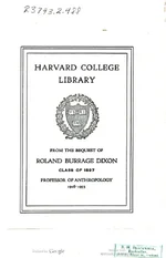
So you believe that the publisher predicted the date of anthropologist Roland Burrage Dixon's death, and printed it in a book 23 years before he died?
Check, and mate.
 

Attachments

  • 1780844518131.webp
    1780844518131.webp
    27.2 KB · Views: 42
So you believe that the publisher predicted the date of anthropologist Roland Burrage Dixon's death, and printed it in a book 23 years before he died?
Check, and mate.
I suppose you don't know what a bequest is. Mr. Dixon donated the book to the library, and that label was added to the book to denote the donation. All you can tell from this is that the label was added to the book after 1935.
 
I suppose you don't know what a bequest is. Mr. Dixon donated the book to the library, and that label was added to the book to denote the donation. All you can tell from this is that the label was added to the book after 1935.
Correct. Note that the book was digitised by Harvard University. However, he will continue to argue the map of Rainbow Island was not published until the mid-1935s because these digital scans do not explicitly contain a publication date (nor does my physical copy). He is wrong of course but he will continue to argue this silly point until a digital scan is shown.

I do not yet have a physical copy with a publication date with the map, although should do in the next few days.

The most annoying thing is someone bought the only two first edition copies (1903) listed by sellers on the internet.

Both were sold yesterday including the copy for £75 I earlier mentioned (the other sold for £202). This cannot have been a coincidence. Someone has read this thread and yesterday bought two first edition copies. Frustrating since I actually need a first edition as I am writing an article and doing research. It is unlikely the person who bought these is going to make use of them.

1780846666041.webp
 
As a prolific writer of fiction, Louis Tracy (or his publishers) obviously plagiarized Kidd's map to illustrate his fantasy story book.
You are going to need to explain how that could have happened.
I predicted this would happen. No matter the evidence, there is always an alibi. Randawg, here's an alibi with deniable plausibility you (or anyone else) can freely use:
  • Louis Tracy was a writer.
  • He bought a writing desk. It was in nice shape except that some idiot had carved "WK" in the top.
  • One day, while suffering writer's block, he was poking around the desk and found a secret compartment.
  • Inside was the map of an island!
  • He used this map to construct his fictional novel, Rainbow Island.
  • He put the original map back in the desk and forgot all about it.
  • Some years later, his wife was in a decluttering mood and sold the desk.
There ya go, we've now alibied away obvious fact for obfuscated fiction.
 
What a heated and somehow annoying discussion this has become! First of all one should acknowledge the immense work and discovery cryptid has done here. As I posted earlier I have my doubt about the causality but I do not like to join a discussion were the arguments are so low to as "How many books have you published?". This is not helpful.
 
A physical copy of a Rainbow Island reprint with a publication date 1917 - arrived in my post today.

It contains the Rainbow Island map.

The map was undeniably published before Hubert Palmer acquired the Kidd-Palmer maps.

I bought several other reprints that are earlier dated than 1917 but they have not yet arrived.

1780915783914.webp

1780915929774.webp

Check, and mate.
Ditto.
 
As I mentioned the Rainbow Island map was slightly changed in reprints over time.
By the 1920s, Robert Jenks' name was removed from underneath the map. The 1917 reprint still contains his name:

1780916874331.webp

Robert Jenks is a fictional character in the novel.

What I have now discovered is that some tildes (~) or squiggles were on the earlier versions of the map (including 1917 reprint):

1780917097474.webp


These were later removed (in 1920s reprints) but you can see whoever drew the Skeleton Map (1933) copied these tildes on the border.

1780917848440.webp


1780917286424.webp


Furthermore, you can see that yards (on the Skeleton Map) was also taken from the Rainbow Island map.

The answer to the directional instructions on the Skeleton Map obviously relate to the Rainbow Island map. You have to use the instructions on the Skeleton Map on the Rainbow Island map (such as measuring by yards [see the scale]) to make sense. It is all fiction. There is no real treasure. This disproves the poster Gjb's far-fetched claims that the instructions on the Skeleton Map point to a deposit on Oak Island.
 
Last edited:
Waiting for the next alibi to drop...
 
Those similarities keep coming.
As I mentioned the Rainbow Island map was slightly changed in reprints over time.
By the 1920s, Robert Jenks' name was removed from underneath the map. The 1917 reprint still contains his name:

View attachment 2256127
Robert Jenks is a fictional character in the novel.

What I have now discovered is that some tildes (~) or squiggles were on the earlier versions of the map (including 1917 reprint):

View attachment 2256128

These were later removed (in 1920s reprints) but you can see whoever drew the Skeleton Map (1933) copied these tildes on the border.

View attachment 2256130

View attachment 2256129

Furthermore, you can see that yards (on the Skeleton Map) was also taken from the Rainbow Island map.

The answer to the directional instructions on the Skeleton Map obviously relate to the Rainbow Island map. You have to use the instructions on the Skeleton Map on the Rainbow Island map (such as measuring by yards [see the scale]) to make sense. It is all fiction. There is no real treasure. This disproves the poster Gjb's far-fetched claims that the instructions on the Skeleton Map point to a deposit on Oak Island.
But does any of it prove what is original and what is copy?

We know that the maps discoveries were fake. But what we don't know yet is who, when and for what purpose they were created. That those maps took the book as inspiration is a valid theory but it can still be argued that it is the other way around. Which will again come down to what one wants to believe.

The publishing date of the book and the maps are only relevant if one believes that those maps have been created shortly before they were sold with the furniture to Palmer (or they had been authentically hidden) but there is no prove of that.

Also there are still similarities between the Avery Letter and the maps - some of it reflects in the RI (Rainbow Island) map others like the "three stumps"/"three grey stones overgrown with grass" are missing.

What still is quite obvious to me is that the RI's features don't make much sense - especially the palm tree growing on that piece of sand in the middle of deep water. The Palmer maps seem to me more real in that regard.

Than there is "Death Valley" - it is not written or drawn on any of the maps but on RI. How did Wilkins know this? Did he know the book but kept silent all the time? Something does not add up!
 
Could not make it up. Rainbow Island buying or bidding wars. :sign10:

Someone watching this thread like a hawk is desperately trying to buy every copy of Rainbow Island listed online. In the last 48 hours virtually all copies have been sold on Ebay, Abebooks, Biblio, and other book selling sites. I also confirmed this by contacting some sellers.

1781012411831.webp


The above was a French seller specialising in rare books. I bought the other reprint from them but then noticed a separate reprint I was going to buy has now sold. The only books currently listed online [excluding worthless modern print-on-demand] is the scarce 1910 reprint (The Romance Book Club) and limited edition paperback edition The Collected Works of Louis Tracy (1904-1907). However, the former is over £400 and the latter is over £2,000 so it seems to be too much for the person frantically trying to buy all the copies.

1781012855558.webp


I noticed what this person was doing a few days ago and so bought all the others including a rare reprint by A. R. Mowbray & Co., 1930.
 
Last edited:
Waiting for the next alibi to drop...
It seems Randawg72 is the staunchest 'true believer' in these maps online. Over a decade ago it was Paul Hawkins:


Like Randawg72, Hawkins rejected any evidence that contradicted or falsified his belief. He debated Peter Barber (MA, FSA, FRHistS) the Map Librarian at the Map Library, the British Library who pointed out exactly the same thing about true believers in these maps, describing them as "people who are usually so convinced of their [the maps] authenticity that they will accept no evidence to the contrary". Hawkins of course lost the debate he had with Barber and ended up deleting his website (the above is an archived webpage). With true believers you often find the Dunning-Kruger effect. This is found in Randawg72 posts, like above. The guy does not even know what a bequest is.
 
Last edited:
It seems Randawg72 is the staunchest 'true believer' in these maps online. Over a decade ago it was Paul Hawkins:


Like Randawg72, Hawkins rejected any evidence that contradicted or falsified his belief. He debated Peter Barber (MA, FSA, FRHistS) the Map Librarian at the Map Library, the British Library who pointed out exactly the same thing about true believers in these maps, describing them as "people who are usually so convinced of their [the maps] authenticity that they will accept no evidence to the contrary". Hawkins of course lost the debate he had with Barber and ended up deleting his website (the above is an archived webpage). With true believers you often find the Dunning-Kruger effect. This is found in Randawg72 posts, like above. The guy does not even know what a bequest is.
I had a good conversation with Peter Barber. He tends to stay away from that debate on the Palmer maps because he sees that, for whatever he says to some people, they never believe because of cognitive bias, sunk-cost fallacy, and egocentric character traits. Trying to debate with people with that mindset is a waste of time and resources.

Cryptid1990, I dare say someone is writing a book somewhere and is riding off the back of your research. But for me personally, I see very little profit margin in such a book these days. I have would be authors, a film documentary makers all the time, contact me after various documents. Their treasure is selling the dream. For me, I search for treasure without getting emotionally or fixated on a particular story or legend. Just try to get the truth. You research the story clinically to its good or bad conclusion, regardless, and move on. Some cannot do that; they fixate obsessively until the legend eats them alive, because it becomes a religion, an unshakeable belief to them.

Your in-depth research has been impressive yet ironic, rather wasted time and resources that could be better spent elsewhere.

I like your analytical skills. If you're ever interested in researching other stories, PM me. I have stories I never post about here.

Crow
 
Could not make it up. Rainbow Island buying or bidding wars. :sign10:

Someone watching this thread like a hawk is desperately trying to buy every copy of Rainbow Island listed online. In the last 48 hours virtually all copies have been sold on Ebay, Abebooks, Biblio, and other book selling sites. I also confirmed this by contacting some sellers.

View attachment 2256232

The above was a French seller specialising in rare books. I bought the other reprint from them but then noticed a separate reprint I was going to buy has now sold. The only books currently listed online [excluding worthless modern print-on-demand] is the scarce 1910 reprint (The Romance Book Club) and limited edition paperback edition The Collected Works of Louis Tracy (1904-1907). However, the former is over £400 and the latter is over £2,000 so it seems to be too much for the person frantically trying to buy all the copies.

View attachment 2256233

I noticed what this person was doing a few days ago and so bought all the others including a rare reprint by A. R. Mowbray & Co., 1930.
Very strange, seems someone here tries to either ride on your works or sabotage it.

I actually tend to think the later as some here can reasonably assume that if the maps are finally solved there work will be worth nothing. This includes book sales and most of all fame.

But I think at this stage the race is still open. Even if the odds for those who claim the maps point to an authentic treasure have very much diminished thanks to your research.

I am reading the book again to find something that proves the maps are a copy of the book and not the other way around. I am not sure...
 
mapoverlay.webp


Just as a reference showing clearly that those maps are the same in many details. (including the direction of the text like Smuggler's Cove!)

Some notable differences:
The "Palm" islet is moved inside the lagoon. Notable too that this island is drawn much further east in the "Coral Island Map".
The west end of the lagoon is moved further out
The RI map is drawn with a finer pencil with much more details in the outlines
"NORTH SA E" is "North Cape" on the RI map
Longitude clearly differs
Yards scale in RI

From a book author's point of view I can understand some of it assuming RI map is the copy:
He moved the Palm islet up so that the protagonist can have his fight with the devil fish. Moving the left side rocks of it closer to the beach serves the same purpose.
He wrote "North Cape" as his fitting interpretation.
He couldn't read clearly the longitude so he changed it to some he did know in the China Sea.
The finer detailed outline because this is how a more modern map would look like

I have a much harder time trying to explain these differences assuming RI is the original.
 

Users who are viewing this thread

Back
Top Bottom