OP
OP
TurtleisGold

TurtleisGold

Jr. Member
Jan 5, 2011
31
16
USA
Detector(s) used
Nothing yet, just my eyes and intuition
Primary Interest:
All Treasure Hunting
After a brief search, it seems there was a Knights of the Golden Circle presence, in the area, before the Civil War.
Are you still interested in learning the history of the site? I don't care about the treasure hunting but I love to explore the history of these types of places.
Sure, send me any and all history information. The Lake of Egypt was a large Copperhead area as well.
 

OP
OP
TurtleisGold

TurtleisGold

Jr. Member
Jan 5, 2011
31
16
USA
Detector(s) used
Nothing yet, just my eyes and intuition
Primary Interest:
All Treasure Hunting
Also, within Giant City State Park, there is a very large Pyramid "EYE" carvings at Rest Area #1, right inside the main gate. Walk up the cliff, and head west on cliff trail. Can't miss it. It's by the main sitting area.
 

mdog

Bronze Member
Mar 22, 2011
2,325
4,380
I could go on and on posting this stuff. Years and years of studying that area and the property lines. I just wanted someone, or anyone, to have access to this info. Go check out Cedar Lake in Illinois yourself. It's a stones throw from Missouri. If anyone wants everything I have, feel free to inquire. I'm done looking, its a morbid curiosity now. I just want to know I'm not crazy for studying this much. Have fun, send a picture if you think you found something cool. Pick up where I left off, I'm out.
You are not crazy. Do you still live close to this area.
 

mdog

Bronze Member
Mar 22, 2011
2,325
4,380
You are not crazy. Do you still live close to this area.
This is a complicated site and what you have found at Cedar Lake, if related, is probably a diversion. The information that I give you is a real conversation killer because I never hear back from anybody but one Tnet poster and he's the guy who gave me the heads up about the group that sets these sites up. The group isn't KGC although some KGC might have been members. They use great circle mapping to connect geographical points that are similar in name. I'll explain how they did it in your area, but you have to be able to plot points on Google Earth.
They use code names and the code name in your area is Wildcat. You might notice that there is a place named Wildcat Bluff about 23 miles SE of Makanda. This Wildcat Bluff has a connection to two other Wildcat Bluffs, one in Iowa and one in Arkansas. The great circle distance between the Illinois Wildcat Bluff and the one in Iowa is 367 miles, Illinois to Arkansas is 355 miles. You can see there is only a difference of 12 miles, too close to be coincidental. The great circle distance between the Iowa Wildcat Bluff and the one in Arkansas is 565 miles. These distances form a triangle with two short sides of 367 miles and 355 miles and a long side of 565 miles. This is a total distance of 1287 miles. I remember you said that you had 13 carved on some of the trees. I believe this number identifies the people who set up the site, kind of like a signature. You will notice that the total miles of the triangle, 1287 miles, is 13 miles short of 1300 miles. Could just be a coincidence, or not. Now for the angles of the triangle, they are 37 degrees in Iowa, 39 degrees in Arkansas and 103 degrees in Illinois, totaling 179 degrees, a little off but you can check it on Google Earth.
Ok, you have three geographical locations connected by name and math and none of them are even close to each other. I don't believe this is coincidence. Are these sites set up to hide treasure? I don't know. I know there is a treasure legend associated with the Arkansas site but I don't know if anything has been found. I came across an article that said the Masons would set up fake "treasure sites", complete with clues and legend, just to get a good laugh as their neighbors tore up the countryside looking for valuables. Who knows. I consider these sites an historical curiosity.
 

mdog

Bronze Member
Mar 22, 2011
2,325
4,380
I'm always surprised that this mapping information doesn't generate any interest. Sdcfia wrote about this type of mapping in his book New Mexico Confidential: 30 Years of Snooping in Obscure Places. Some of these mapping points are close to areas associated with treasure legends. In fact, treasure legend terrain features are sometime a part of the mapping.
Anyway, here is more information about the Wildcat Bluff triangle. A few miles from Wildcat Bluff, Iowa is a town named Center Point. About nine miles from Wildcat Bluff, Ark., is a town named Center Point. I couldn't find any evidence of a town named Center Point near Wildcat Bluff, Ill., but here is where Google Earth comes in real handy. If you map a line from Wildcat Bluff, Ill. to the midpoint of the line that connects Wildcat Bluff, Iowa to Wildcat Bluff, Ark., that line passes by two peaks in eastern Missouri named Wildcat Mountain. These two mountains are about 35 miles apart on a NE to SW line. If you run a line from the NE Wildcat Mt. to the SW Wildcat Mt. and extend that line across Texas, you will pass right through a town named Center Point. So, we have three Wildcat Buffs, with two close to towns named Center Point and one associated with a town named Center Point, by code. Here are a couple of interesting facts about Center Point, Texas. Turtleisgold, you mentioned a pyramid/eye carving at Giant City. The latitude of Center Point, Texas is 29 dgrees 57' 08". The latitude of the Great Pyramid of Giza, Egypt is 29 degrees 58' 34". Also, just north of St. Augustine, Florida, is the same latitude as Center Point, Texas, 29 degrees 57' 08". The distance from Center Point, Texas to St. Augustine, Florida is 1062 miles. The distance from Center Point, Texas to the southwestern most point in the United States is 1083 miles. So Center Point is pretty much the center point of the southern United States.
In the area about 25 miles NW of Wildcat Bluff, Arkansas, the treasure hunter, Bob Brewer, recovered two or three treasure caches that he documented in his book Rebel Gold. His treasure trails also included carvings on trees.
 

OP
OP
TurtleisGold

TurtleisGold

Jr. Member
Jan 5, 2011
31
16
USA
Detector(s) used
Nothing yet, just my eyes and intuition
Primary Interest:
All Treasure Hunting
Thanks for the info. There's a Centralia IL, close-ish to these trees. Probably about 50 miles away. That's the only Center Point I can think of. There's a lot of Confederate graves in the area, and a lot of Confederate sympathy. I think it's worth noting or talking about Murphysboro IL, and General John A Logan. The first Memorial Day parade was in Murphysboro IL, hosted by Genral Logan, with Confederate and Union troops alike. There's a Murphysboro in almost every state as well. Just spelled differently. I now live in Denver CO, but always think about Cedar Lake. There's several Natural Bridges in the area too, including Pamona Natural Land Bridge, and a area known as the Valley of the Caves. In the Black Book "Jesse James Was One of His Names", there was a page that listed many of his aliases. Jim McDaniels was one that stood out to me. Some property in the area is registered to a Jim McDaniels, there's a McDaniels road, McDaniels school etc. All very close to that area.
 

OP
OP
TurtleisGold

TurtleisGold

Jr. Member
Jan 5, 2011
31
16
USA
Detector(s) used
Nothing yet, just my eyes and intuition
Primary Interest:
All Treasure Hunting
Please DM me, I'll give you my phone number and we can talk at great length.
 

OP
OP
TurtleisGold

TurtleisGold

Jr. Member
Jan 5, 2011
31
16
USA
Detector(s) used
Nothing yet, just my eyes and intuition
Primary Interest:
All Treasure Hunting
Screenshot_20220413-121546_Chrome.jpg

This is a bad old picture, but only Picture I could quickly find on Shelter 1 inside Giant City State Park. The pyramid with Mason Signs is carved roughly right on the RED DOT. Can't miss it, if you walk up trail behind the shelter, then walk down the ridge. Hooe this helps.
 

OP
OP
TurtleisGold

TurtleisGold

Jr. Member
Jan 5, 2011
31
16
USA
Detector(s) used
Nothing yet, just my eyes and intuition
Primary Interest:
All Treasure Hunting
I'm always surprised that this mapping information doesn't generate any interest. Sdcfia wrote about this type of mapping in his book New Mexico Confidential: 30 Years of Snooping in Obscure Places. Some of these mapping points are close to areas associated with treasure legends. In fact, treasure legend terrain features are sometime a part of the mapping.
Anyway, here is more information about the Wildcat Bluff triangle. A few miles from Wildcat Bluff, Iowa is a town named Center Point. About nine miles from Wildcat Bluff, Ark., is a town named Center Point. I couldn't find any evidence of a town named Center Point near Wildcat Bluff, Ill., but here is where Google Earth comes in real handy. If you map a line from Wildcat Bluff, Ill. to the midpoint of the line that connects Wildcat Bluff, Iowa to Wildcat Bluff, Ark., that line passes by two peaks in eastern Missouri named Wildcat Mountain. These two mountains are about 35 miles apart on a NE to SW line. If you run a line from the NE Wildcat Mt. to the SW Wildcat Mt. and extend that line across Texas, you will pass right through a town named Center Point. So, we have three Wildcat Buffs, with two close to towns named Center Point and one associated with a town named Center Point, by code. Here are a couple of interesting facts about Center Point, Texas. Turtleisgold, you mentioned a pyramid/eye carving at Giant City. The latitude of Center Point, Texas is 29 dgrees 57' 08". The latitude of the Great Pyramid of Giza, Egypt is 29 degrees 58' 34". Also, just north of St. Augustine, Florida, is the same latitude as Center Point, Texas, 29 degrees 57' 08". The distance from Center Point, Texas to St. Augustine, Florida is 1062 miles. The distance from Center Point, Texas to the southwestern most point in the United States is 1083 miles. So Center Point is pretty much the center point of the southern United States.
In the area about 25 miles NW of Wildcat Bluff, Arkansas, the treasure hunter, Bob Brewer, recovered two or three treasure caches that he documented in his book Rebel Gold. His treasure trails also included carvings on trees.
See all new posts I put up. Dm me and I'll give you my phone number.
 

OP
OP
TurtleisGold

TurtleisGold

Jr. Member
Jan 5, 2011
31
16
USA
Detector(s) used
Nothing yet, just my eyes and intuition
Primary Interest:
All Treasure Hunting
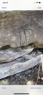
Anchor J with a P
Hey, just logged back on for the first time in awhile. I really hope my post helped in any kind of way. That's so awesome if you found those rock carvings in the vicinity. If you want more info, feel free to DM.

Nick
 

OP
OP
TurtleisGold

TurtleisGold

Jr. Member
Jan 5, 2011
31
16
USA
Detector(s) used
Nothing yet, just my eyes and intuition
Primary Interest:
All Treasure Hunting
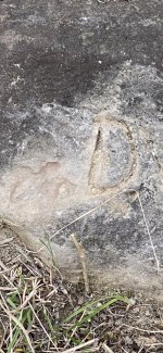
Looks like some kind of bird to me
The left carving looks more like a turtle to me, right looks like a "D". I hope this post helped you find something cool. Thanks for responding. DM for more info
 

OP
OP
TurtleisGold

TurtleisGold

Jr. Member
Jan 5, 2011
31
16
USA
Detector(s) used
Nothing yet, just my eyes and intuition
Primary Interest:
All Treasure Hunting
I have the utmost respect for you sir
I hope the information helped you. Sorry for a slow reply. Keep hunting. DM if you want more questions answered.
 

OP
OP
TurtleisGold

TurtleisGold

Jr. Member
Jan 5, 2011
31
16
USA
Detector(s) used
Nothing yet, just my eyes and intuition
Primary Interest:
All Treasure Hunting
20220822_125907.jpg
20220822_125915.jpg
20220822_125926.jpg
20220822_125941.jpg
20220822_130034.jpg
20220822_130103.jpg
20220822_130103.jpg
20220822_131009.jpg
20220822_130958.jpg
20220822_130958.jpg
20220822_131025.jpg
20220822_131050.jpg
20220822_131149.jpg
20220822_131416.jpg
20220822_131343.jpg
20220822_131309.jpg
20220822_132157.jpg
20220822_135802.jpg
20220822_135807.jpg
20220822_135805.jpg
20220822_135813.jpg
20220822_135915.jpg
20220822_140403.jpg
20220822_140327.jpg
20220822_140407.jpg
20220822_140743.jpg
20220822_141013.jpg
20220822_142215.jpg
20220822_142240.jpg
20220822_142254.jpg
20220822_145059.jpg


I went back after 10 years or more, and took better pictures of the same trees. Some of the trees had fallen, others leaning against a cliff. Hope this helps.
 

OP
OP
TurtleisGold

TurtleisGold

Jr. Member
Jan 5, 2011
31
16
USA
Detector(s) used
Nothing yet, just my eyes and intuition
Primary Interest:
All Treasure Hunting


Here's a video, of all the carvings to see
 

Sep 28, 2022
1
1
See all new posts I put up. Dm me and I'll give you my phone number.

I'll be heading to Wildcat Bluff, Ar a week from tomorrow. I want to get a visual of the cliffs (I've seen pictures) in person. I'm curious to see if I can find any carvings there. I've read stories about events occuring there during the civil war which include Jesse James. I've read Brewer's book, "Shadow of the Sentinel" which I think is a remake of "Rebel Gold." Any thoughts on what I should be looking for when I get there? Thanks
 

Top Member Reactions

Users who are viewing this thread

Top