You are using an out of date browser. It may not display this or other websites correctly.
You should upgrade or use an alternative browser.
You should upgrade or use an alternative browser.
Superstition People, Places, & Things.
- Thread starter Hal Croves
- Start date
- Status
- Not open for further replies.
deducer
Bronze Member
Much bigger? Tortilla flows after heavy rain. "Water rose 50 feet in some places... tragically, three people died who tried to cross the next wash up from Tortilla Flat. Their pickup found smashed to bits". The flash flood of Labor Day 1970. Another flood in 42' destroyed most of the town.
So, it can grow to be very big and very dangerous. But the length of the Tortilla Creek has been shortened by approximately 2 miles. The last two miles is now under Canyon Lake.
My source is Glover Military maps, "Tortilla Flat AZ Now & Then", an the AZ republic.
Hal,
Understood- what I meant to say was, was there a time when Tortilla creek flowed continuously? I'm well aware it's a raging river during heavy rain and I've almost got caught once or twice- one of these days my luck is going to run out.
I'm thinking that part of the reason why it's bone dry most of the time is because most of what feeds it has been diverted, dammed, or otherwise interfered with?
ConceptualizedNetherlandr
Silver Member
- Joined
- Apr 17, 2014
- Messages
- 2,669
- Reaction score
- 2,307
- Golden Thread
- 0
- Location
- Sagittarius A*
- Primary Interest:
- Other
Hal,
Understood- what I meant to say was, was there a time when Tortilla creek flowed continuously? I'm well aware it's a raging river during heavy rain and I've almost got caught once or twice- one of these days my luck is going to run out.
I'm thinking that part of the reason why it's bone dry most of the time is because most of what feeds it has been diverted, dammed, or otherwise interfered with?
A small watershed has a fast response to precipitation events and vice versa with a large watershed.
cactusjumper
Gold Member
Hang in there Joe. I'd feel lost if I didn't have someone to continually disagree with.
deducer,
You disagree with me?

Take care,
Joe
markmar
Silver Member
- Joined
- Oct 17, 2012
- Messages
- 4,302
- Reaction score
- 6,537
- Golden Thread
- 0
- Primary Interest:
- All Treasure Hunting
Superstitions places & things
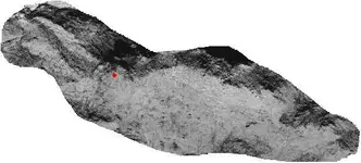
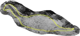
Many have scratched their heads while examining the reptile on the Tucson artifact . In reality this reptile is an image of a mountain range in the Superstitions which with another land formations , looks like the reptile ( Diplodocus ) from the artifact .
The red dot is where the stone trail ends .


Coincidence ? I don't think so .
Many have scratched their heads while examining the reptile on the Tucson artifact . In reality this reptile is an image of a mountain range in the Superstitions which with another land formations , looks like the reptile ( Diplodocus ) from the artifact .
The red dot is where the stone trail ends .


Coincidence ? I don't think so .
Real de Tayopa Tropical Tramp
Gold Member
- Joined
- Nov 8, 2004
- Messages
- 14,582
- Reaction score
- 11,947
- Golden Thread
- 0
- Location
- Alamos,Sonora,Mexico
- Primary Interest:
- All Treasure Hunting
so do I joe, on what ever it is, cepting on how to cook pasta. 


 < ------------- after an operation like that only coffee is allowed, no hard stuff.


 < ------------- after an operation like that only coffee is allowed, no hard stuff.
gollum
Gold Member
- Joined
- Jan 2, 2006
- Messages
- 6,770
- Reaction score
- 7,739
- Golden Thread
- 0
- Location
- Arizona Vagrant
- Detector(s) used
- Minelab SD2200D (Modded)/ Whites GMT 24k / Fisher FX-3 / Fisher Gold Bug II / Fisher Gemini / Schiebel MIMID / Falcon MD-20
- Primary Interest:
- All Treasure Hunting
Hey Joe,
I hope you are doing well.
Take Care - Mike
I hope you are doing well.
Take Care - Mike
cactusjumper
Gold Member
Thanks Mike,
It's a day to day thing. I get plenty of time on the good side, so no complaints.
Hope all is well with you.
Take care,
Joe
It's a day to day thing. I get plenty of time on the good side, so no complaints.
Hope all is well with you.
Take care,
Joe
cactusjumper
Gold Member
Many thanks for the well wishes. I am doing much better these days.
Take care,
Joe
Take care,
Joe
Real de Tayopa Tropical Tramp
Gold Member
- Joined
- Nov 8, 2004
- Messages
- 14,582
- Reaction score
- 11,947
- Golden Thread
- 0
- Location
- Alamos,Sonora,Mexico
- Primary Interest:
- All Treasure Hunting
Joe, if he doesn't I will.
Huh. I had imagined you would be more tan.
Hang in there.
If you get feelin too good holler , and some one might be willing to poke you with a stick....

cw0909
Silver Member
Many thanks for the well wishes. I am doing much better these days.
Take care,
Joe
glad to hear that, you look a little under the weather in that last pic
had a friend her head had bandages, needed a platinum aneurysm coil
all is good now 10+ yrs later
Loke
Hero Member
- Joined
- Mar 24, 2010
- Messages
- 589
- Reaction score
- 1,383
- Golden Thread
- 0
- Location
- Republic of Texas
- Primary Interest:
- All Treasure Hunting
All the best, Joe - my prayers are with you! (and sorry I'm 'late' to the party ...)
Real de Tayopa Tropical Tramp
Gold Member
- Joined
- Nov 8, 2004
- Messages
- 14,582
- Reaction score
- 11,947
- Golden Thread
- 0
- Location
- Alamos,Sonora,Mexico
- Primary Interest:
- All Treasure Hunting
Is that a pasta belly that I see joe?? Incidentally do you still have my steak in the freezer??
deducer
Bronze Member
On a side note, did you know that the suggested alternate name for Weaver's Needle was El Cuchillo "The Knife". Suggested after Chuchillo Negro "Black Knife" Apache Chief. Something to think about when looking at these old treasure maps of the Superstitions.
I didn't know that. Certainly food for thought.
I believe Jim Hatt mentioned he came across a number of arrastres in LaBarge Canyon/creek near Canyon Lake. Said it looked like something sizable was going on down there.
EarnieP
Hero Member
- Joined
- Jul 20, 2015
- Messages
- 526
- Reaction score
- 1,062
- Golden Thread
- 0
- Primary Interest:
- All Treasure Hunting
--------This is where technology shines and one of my favorite images. We can clearly see where First Water Creek flowed directly into the Salt River. Tortilla Creek also. But, notice how La Barge flows into Tortilla Creek and not directly into the Salt. This is exactly the same on the Military Trail Map. This may not seem important however, if you are following some of the old clues and studying the maps, this is critical.
From a Jim Hatt post on that other site.
A reprint of the December 1983 Barry Storm article in Desert Magazine;
..."Clark tried to find the source of the gold which he had seen with his own eyes; then both he and his son searched, still unsuccessfully. They did considerable placering in LaBarge canyon with small success, entirely overlooking the fact that it is really a tributary of Tortilla creek, coming into the latter near its mouth." (of interest to Hal?)
"To this day Tortilla creek is still unrecognized as the true Canon Fresco. Here, Russel Perkins of Tortilla Flat reported finding huge ash piles and other remains of an obviously large encampment, and Clark's son, Carl, stumbled upon a piece of hexagon drill steel sharpened Spanish-style in the form of a pointed, four edged spearhead instead of the chisel bit style used by American miners."... (of interest to Bill Riley?)
Last edited:
Azquester
Bronze Member
- Joined
- Dec 15, 2006
- Messages
- 1,737
- Reaction score
- 2,603
- Golden Thread
- 0
- Primary Interest:
- All Treasure Hunting
Ernie, Spear Head style? That's alright by me. I believe the other link you provided answered my question. More of a free mason style just plain old chisel. The spear headed tipped chisel I found once and thought it was newer so I left it there. I'll need to search my archives for the location.
lots of ways to date a site.
I use Match Dot Treasure Dot com.
Gets me close but no real commitment's.
lots of ways to date a site.
I use Match Dot Treasure Dot com.
Gets me close but no real commitment's.
Real de Tayopa Tropical Tramp
Gold Member
- Joined
- Nov 8, 2004
- Messages
- 14,582
- Reaction score
- 11,947
- Golden Thread
- 0
- Location
- Alamos,Sonora,Mexico
- Primary Interest:
- All Treasure Hunting
Hi, may I aso say that the different shades indicate different depths, hence different amounts of flow.
- Status
- Not open for further replies.
Similar threads
- Replies
- 9
- Views
- 2K
- Replies
- 65
- Views
- 5K
Users who are viewing this thread
Total: 2 (members: 0, guests: 2)


