What's new

When might a map of Oak Island not be Oak Island?

gjb

Sr. Member
Joined
Apr 21, 2016
Messages
451
Reaction score
429
Golden Thread
0
Location
UK
Detector(s) used
Garrett Ace 300i
Garrett EuroAce
Primary Interest:
All Treasure Hunting
When concluding otherwise would be most inconvenient!

I hold that there’s an important Oak Island anomaly that should be considered objectively, and assessed in similar fashion, rather than starting out with the answer that people want to hear and believe.

I’m constantly being told that I’m wrong about a particular suggestion and would like to get the matter fully out into the open and discussed, with people declaring where they stand on the subject and why.

In his book, Captain Kidd and His Skeleton Island, Harold Wilkins not only presents the two contentious Wilkins-Kidd (Mar Del) maps but also includes the outline of another 'treasure’ island that he refers to as 'John S’s Rough Map' (1934, p.345, UK edition; 1937, p.383, US edition)

John S Map.gif


Wilkins claims not to know its identity and asks his readers, “where is this treasure island?” I suggest that the outline has every appearance of being Oak Island as depicted by the cartographer J.F.W. Des Barres in his collection of charts including Nova Scotia The Atlantic Neptune (1775), under the name of Gloucester Isle. For easier comparison, I've slightly reduced the y axis of the Rough Map as below:

OI Gloucs John S.gif


Note well the ‘bulb’ at the eastern extremity of both outlines and the common ‘inlet’ or ‘cove’ at the northwest. Note also the two apparent ‘rivers’ depicted in virtually the same locations, these potentially being positioned at the gaps in the tree line created by the ancient roadway. We know that Gloucester Isle is definitely Oak Island and we know that the island has no water courses where indicated. So, what else might they be?

I’ve been told that this cannot possibly be Oak Island because of the orientation (the compass rose on the original) and because the island doesn’t have a lagoon at northwest, which completely ignores the possibility of misguided elaboration or subterfuge (thus, as above, remove these and then do the comparison).

When I’ve suggested that the two interior crosses might be positioned to represent a portion of Nolan’s Cross (perhaps Cone A and the Head Stone?) I’ve been told that this cannot be because Nolan’s Cross is a fake. However, this is something we don’t know for a fact. The Rough Map was drawn pre-1934, well before Nolan’s Cross was discovered, so this would mean that somebody had prior knowledge of the Cross and wanted to draw attention to it.

Some do observe that Gloucester Isle isn’t precisely like Oak Island, so a rough copy of it wouldn’t be either. I generally find that those who vehemently deny that the map could even remotely be Oak Island are those who are simply not prepared to contemplate the possibility due to the inconvenient implications of this being so.

What do you think? Could John S’s Rough Map possibly be a representation of Oak Island? Please try to be objective and support your conclusions, specifically if negative, with observations that everyone can check out and assess for themselves.
 
Thats not Oak Island, That's Hatteras Island, North Carolina
Why is everybody so fascinated with Oak Island Nova Scotia anyways? Why would Kidd ever of went to Nova Scotia? It's so ridiculous. I guess Nova Scotia is just hard up for stories and tourists? Anybody in the know, knows the Oak Island Money Pit is a joke.
 
Thats not Oak Island, That's Hatteras Island, North Carolina
Why is everybody so fascinated with Oak Island Nova Scotia anyways? Why would Kidd ever of went to Nova Scotia? It's so ridiculous. I guess Nova Scotia is just hard up for stories and tourists? Anybody in the know, knows the Oak Island Money Pit is a joke.
Exactly as I predicted: a total lack of objectivity, and outright bias! You know full well it doesn't look at all like Hatteras Island NC.

Furthermore, I never said Kidd went to Nova Scotia, and personally I don't believe he did. I never said the Money Pit isn't a joke, because that's what it looks to have become.

I simply asked, by comparing the two maps, could it be that the Rough Map is a depiction of Gloucester Isle? You decided not to provide an answer to that question because you jumped to the wrong conclusions having decided the answer before you even saw the question.

I'm sorry to say that this has become far too typical of this forum and, as a result, it's going nowhere, which I assume is the sole objective of your being here and providing such ridiculous and unhelpful comments.
 
No matter what side of the fence your on, I do agree with your sentiment that way to many people are biased based on their own personal beliefs which makes talking with open minds almost impossible on this site about what actually happened on Oak Island which is why the Indigenous peoples who are maybe the only ones through oral history have any real idea of its real history... Being a researcher of Indigenous history on NA Eastern seaboard not many are willing to risk ridicule by Arm Chair experts making fun of others as some form of sport... One thing is for sure, some thing was there as proof of white Europeans in the area is all up and down the area...

The Lagina's and History Channel have pretty much destroyed the ability for people to have open discussions as the level of bullshit in their effort to keep attracting people to the money machine has created so much fodder for people to ridicule its scared off most of any the people doing any real historical research on the topic... Its a White Man's game as it attracts unsuspecting people interested in the story that have in most cases done no real research on the topic but to satisfy their own ego's sit and poke fun at others... History Channel in its efforts to create revenue streams has destroyed places like this for any real discussions... Not attacking this site as on other topics I find more meaningful threads that are help full if your into the subject matter those threads cover... Theres not many other places outside here anymore that cover the Oak Island Story as theyve disaapeared over the years or become private closed discussions on forums not open to the public leaving TN as the quickest and easiest place from the Internet to follow up on what they see on HC and the Show... With the amount of Arm Chair experts here its hard to know who actually knows stuff and who's just looking to massage their ego's and make sport and riducule of others... The best one can do is say what you think and hope to attract attention from other like minded researchers and hopefully others will invite you into their closed conversations as talking about hear wil just invite ridicule from way to many sitting here...

Its the same BS as people still in this day and age insisting Columbus was the 1st with many of those closed minded being socalled academics who still peddle that kind of crap... Don't let others ridicule your interests and endeavours as obviously there's a history in the area that goes back long before the Europeans prior to the Acadians who came in the very early 1600's... History Channel's interests are in making money (The Real Treasure?) NOT what really happened as pretty much everyone involved in the show short of a couple actually know diddly shit about history or what really happened there which leads them to some of the stupidest assumptions that make its so easy to riducle which is the prevailing thoughts of most here...

History is fun to learn as a hobby or serious interest but don't let others deter you from your thinking as history has shown countless times that the so-called experts are more often full of bs and out right wrong... Have fun and continue your journey...
 
Exactly as I predicted: a total lack of objectivity, and outright bias! You know full well it doesn't look at all like Hatteras Island NC.

Furthermore, I never said Kidd went to Nova Scotia, and personally I don't believe he did. I never said the Money Pit isn't a joke, because that's what it looks to have become.

I simply asked, by comparing the two maps, could it be that the Rough Map is a depiction of Gloucester Isle? You decided not to provide an answer to that question because you jumped to the wrong conclusions having decided the answer before you even saw the question.

I'm sorry to say that this has become far too typical of this forum and, as a result, it's going nowhere, which I assume is the sole objective of your being here and providing such ridiculous and unhelpful comments.
Meh, Aint Gloucester Isle either
😆
Whatever Island it is, Its probably in the Caribbien, in fact That Island shape looks familiar.
looks like Nassau.
Good Luck
 
Last edited:
Actually I might of responded to the wrong post about Oak Island.
🤣
Just kind of sick of Oak Island debate.
🤣
My guess is if there is any Kidd Treasure still left, it's probably around North Carolina, or maybe still buried somewhere around Port Royal, Jamaica.
 
Looking at your map, LAGOON implies being circled by a coral reef, and without a sea entrance?
Are coral reefs more common in southern climes?
Dunno is why I ask.
 
Some things to keep in mind: nearly all maps drawn before the age of aerial photography (1858) and powered flight (late 1880s) would be subject to distortions, as getting the bird's eye view was practically impossible. We would certainly find it unlikely that a pirate ship or other maritime vessel in the age of sail would be packing a hot air balloon as standard equipment.

Add in that many of these specimens were supposedly drawn from memory and significant deviations from the "actual" contours as they appear today should be expected. In fact, it would be weirder if the maps were accurate, under the circumstances. This is not to say I'm calling any specific one authentic, just showing that any given one's "poor likeness" argument should be taken with a grain of salt.

In a related vein, we know that some amount of sea level change has occurred since the origin story, and potentially even more since the pre-settler activities. In my perusings through the various Oak Island sites out there, one thing I've yet to see is a detailed, location-specific and scientific depiction of what the contours of the island would have looked like in 1600, 1700, etc., based on the mapped topography of the sea around the island. I've seen the stat "8 feet" of sea level rise thrown around, but how does that translate? Maybe someone here can point to references I've not seen.

--GT
 
Exactly as I predicted: a total lack of objectivity, and outright bias! You know full well it doesn't look at all like Hatteras Island NC.

Furthermore, I never said Kidd went to Nova Scotia, and personally I don't believe he did. I never said the Money Pit isn't a joke, because that's what it looks to have become.

I simply asked, by comparing the two maps, could it be that the Rough Map is a depiction of Gloucester Isle? You decided not to provide an answer to that question because you jumped to the wrong conclusions having decided the answer before you even saw the question.

I'm sorry to say that this has become far too typical of this forum and, as a result, it's going nowhere, which I assume is the sole objective of your being here and providing such ridiculous and unhelpful comments.
Here's how i would solve this problem...

According to Google AI
A pirate in the 1700s would draw an island map using stolen, hand-copied nautical charts

This would suggest the island was sketched from a larger map in order to write more detailed information to find the treasure.

So i would look for the larger map from the 1600 to see if there is an island on it with the same shape.
 
Wether Kidd was ever there I don't think anyone has ever proved it one way or the other,,, BUT as for Pirates they were around that area as well as the mouth of the St. Lawrence before Lunenburg or Mahone Bay were settlements... So the idea of Pirates being around Oak Island is not as unbelievable as some here consistently say...
 
Here's how i would solve this problem...

According to Google AI
A pirate in the 1700s would draw an island map using stolen, hand-copied nautical charts

This would suggest the island was sketched from a larger map in order to write more detailed information to find the treasure.

So i would look for the larger map from the 1600 to see if there is an island on it with the same shape.
I decided to test this theory...
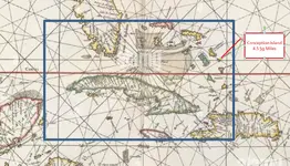
I found a 1600 navigational map. I then superimposed Google maps over the blue rectangul and adjusted and scaled to match the 1600 map the best i could.

I was then able to identify the smallest island on the 1690 map as Conception Island.

Conception Island is 4.5 sq miles (11.6sq km) and shown on the map as a small circle with no detail of its shoreline or inlets.

Oak Island is 0.2 sq miles (0.518 sq km) so i doubt it would show up on a navigational map.

Assuming the "gjb's" map is of oak island, the outline could not been draw from a larger navigational map

If the you were to find an island shaped like "gjb's" map, it would be too lage to be oak island.
 

Attachments

  • Island Size.webp
    Island Size.webp
    122.2 KB · Views: 89
I decided to test this theory...
I found a 1600 navigational map. I then superimposed Google maps over the blue rectangul and adjusted and scaled to match the 1600 map the best i could.

I was then able to identify the smallest island on the 1690 map as Conception Island.

Conception Island is 4.5 sq miles (11.6sq km) and shown on the map as a small circle with no detail of its shoreline or inlets.

Oak Island is 0.2 sq miles (0.518 sq km) so i doubt it would show up on a navigational map.

Assuming the "gjb's" map is of oak island, the outline could not been draw from a larger navigational map

If the you were to find an island shaped like "gjb's" map, it would be too lage to be oak

I decided to test this theory...
I found a 1600 navigational map. I then superimposed Google maps over the blue rectangul and adjusted and scaled to match the 1600 map the best i could.

I was then able to identify the smallest island on the 1690 map as Conception Island.

Conception Island is 4.5 sq miles (11.6sq km) and shown on the map as a small circle with no detail of its shoreline or inlets.

Oak Island is 0.2 sq miles (0.518 sq km) so i doubt it would show up on a navigational map.

Assuming the "gjb's" map is of oak island, the outline could not been draw from a larger navigational map

If the you were to find an island shaped like "gjb's" map, it would be too lage to be oak island.
If an island was too small to draw its outline from a larger navigational map then it would be drawn from scratch...

A 17th-century captain would outline an island by sailing close to its shore, using tools like a sextant for latitude and dead reckoning (estimating position from speed/direction) for longitude, sketching coastal features (bays, capes, rivers) with bearings and estimated distances, and then using mathematical techniques like triangulation (measuring angles to landmarks) and notes from sighted coastal points to create a rough chart, a blend of observation, estimation, and basic trigonometry to build a navigable map.
 
Not so sure about this theory.
I bet you could do a pretty good detailed map if the island wasn't that big and you could sail around it, and were just plain familiar with and somewhat a skilled map maker.
But at some point it would probably just be too much. What size Island???
 
If an island was too small to draw its outline from a larger navigational map then it would be drawn from scratch...

A 17th-century captain would outline an island by sailing close to its shore, using tools like a sextant for latitude and dead reckoning (estimating position from speed/direction) for longitude, sketching coastal features (bays, capes, rivers) with bearings and estimated distances, and then using mathematical techniques like triangulation (measuring angles to landmarks) and notes from sighted coastal points to create a rough chart, a blend of observation, estimation, and basic trigonometry to build a navigable map.
If this method was used by a depositor, the resulting map would have many inaccuracies so
Not so sure about this theory.
I bet you could do a pretty good detailed map if the island wasn't that big and you could sail around it, and were just plain familiar with and somewhat a skilled map maker.
But at some point it would probably just be too much. What size Island

Not so sure about this theory.
I bet you could do a pretty good detailed map if the island wasn't that big and you could sail around it, and were just plain familiar with and somewhat a skilled map maker.
But at some point it would probably just be too much. What size Island???
I believe we are in agreement...
I mentioned two approaches:
1. A pirate could obtain an island outline and shape from a larger navigational map. However, Oak Island would not appear because it is too small.
2. The pirate would sail around the island and draw the outline. Navigational methods of that period, as you indicated would produce a pretty accurate map.

Had Approach 1 actually been viable, one could match the island sketch to an island on the larger navigational map and get Lat/Long location.

Without a Lat/Long location the sketch, if not fake, could be anywhere in the world.
You might as well be looking for the magic document to decode Cipher 1 of the Beale story.
 
If this method was used by a depositor, the resulting map would have many inaccuracies so


I believe we are in agreement...
I mentioned two approaches:
1. A pirate could obtain an island outline and shape from a larger navigational map. However, Oak Island would not appear because it is too small.
2. The pirate would sail around the island and draw the outline. Navigational methods of that period, as you indicated would produce a pretty accurate map.

Had Approach 1 actually been viable, one could match the island sketch to an island on the larger navigational map and get Lat/Long location.

Without a Lat/Long location the sketch, if not fake, could be anywhere in the world.
You might as well be looking for the magic document to decode Cipher 1 of the Beale story.
I assume a cartographer would be focused on mapping the major coast lines of continents or large island for a large navigational map. During this process they would encounter smaller islands which they would sail around and get a general outline. The accuracy would depend on how import the island was perceived.

Had they encountered oak island, i don't believe they could have sailed through the area where the causway is now and im not sure they would think it was important enough to use a row boat to complete the OI outline.

Im speculating so if there is someone with better knowledge and sources, please correct me...id rather know than guess.
 
Are there any other sources on John S’s Rough Map aside from Wilkins (1935 [1937)?

1768443091301.webp


1768443217456.webp

1768443141034.webp

1768443173801.webp
 
Last edited:
Are there any other sources on John S’s Rough Map aside from Wilkins (1935 [1937)?

View attachment 2240956

View attachment 2240959
View attachment 2240957
View attachment 2240958
I’ve never seen it published elsewhere, but I’ve personally seen a version very similar, though that doesn’t count for much. It was inked on slightly yellowed laid paper with minor foxing. The real significance to me was what else was written on the sheet and what else was in the file with it. This is why I feel that there should be some interest in looking into what happened to that file and its apparent companion. I'm sure you'll know what I'm talking about, and also that I'm not convinced about the 'rummers'.

I also think, from what Wilkins wrote, that he was fully aware of the map's provenance, though not the island's identity.
 
I’ve never seen it published elsewhere, but I’ve personally seen a version very similar, though that doesn’t count for much. It was inked on slightly yellowed laid paper with minor foxing. The real significance to me was what else was written on the sheet and what else was in the file with it. This is why I feel that there should be some interest in looking into what happened to that file and its apparent companion. I'm sure you'll know what I'm talking about, and also that I'm not convinced about the 'rummers'.

I also think, from what Wilkins wrote, that he was fully aware of the map's provenance, though not the island's identity.
Wilkins likely confused drinking horns (what he described as "horn drinking mugs") with powder horns. I have searched extensively online and there are no drinking horns from 17th-early 20th centuries with pirate/buccaneer motifs. I could not find a single drinking horn from that period with carvings of skull and crossbones (Jolly Roger), treasure chests, cutlasses, etc. Wilkins further appears to have mistakenly described the drinking horns in Hubert Palmer's collection as "rummers" which are instead made of glass. While there are many examples of rummers with carved nautical motifs (namely ships), you seldom, if ever, find pirate motifs on these. However, there are powder horns dating from this time period which have carved maps, islands, and even pirate motifs on them.

Regardless of whether the objects are drinking horns or powder horns, we can make an educated guess about their age.

1768509417364.webp


The carving of the ship (especially its lower half) does certainly not look 17th-18th century (it is too modern). It looks to me early 20th century. You might have already noted this in one of your books if I remember correctly? I cannot now find the page. Anyway, as for the island, I personally believe the person who made the carving had Wild Cat Island in their mind and based it on that fictional island from Swallows and Amazons (1930). See similarity of compass and island shape -

1768511382578.webp

1768511426401.webp


Furthermore, in Swallows and Amazons the map was drawn by a John (John Walker) who was a "Swallow" (the "Swallows" are the four Walker children: John, Susan, Titty, and Roger and they named their dinghy the Swallow). So John S. = John Swallow.

The powder horns themselves are probably 17th or 18th century but the carvings on them are much more recent (early 1930s).
 
Wilkins likely confused drinking horns (what he described as "horn drinking mugs") with powder horns. I have searched extensively online and there are no drinking horns from 17th-early 20th centuries with pirate/buccaneer motifs. I could not find a single drinking horn from that period with carvings of skull and crossbones (Jolly Roger), treasure chests, cutlasses, etc. Wilkins further appears to have mistakenly described the drinking horns in Hubert Palmer's collection as "rummers" which are instead made of glass. While there are many examples of rummers with carved nautical motifs (namely ships), you seldom, if ever, find pirate motifs on these. However, there are powder horns dating from this time period which have carved maps, islands, and even pirate motifs on them.

Regardless of whether the objects are drinking horns or powder horns, we can make an educated guess about their age.

View attachment 2241016

The carving of the ship (especially its lower half) does certainly not look 17th-18th century (it is too modern). It looks to me early 20th century. You might have already noted this in one of your books if I remember correctly? I cannot now find the page. Anyway, as for the island, I personally believe the person who made the carving had Wild Cat Island in their mind and based it on that fictional island from Swallows and Amazons (1930). See similarity of compass and island shape -

View attachment 2241019
View attachment 2241020

Furthermore, in Swallows and Amazons the map was drawn by a John (John Walker) who was a "Swallow" (the "Swallows" are the four Walker children: John, Susan, Titty, and Roger and they named their dinghy the Swallow). So John S. = John Swallow.

The powder horns themselves are probably 17th or 18th century but the carvings on them are much more recent (early 1930s).
Quite interesting find - I wonder how this is connected to the other Wilkins Kidd maps?

The vessel is a Brigantine and could represent a late 18th or 19th century privateer - those build to be fast and agile with low draft and low dead rise. In the 19th century most would have preferred 'Virginia Schooner' (also named 'Baltimore Clipper')
 
Quite interesting find - I wonder how this is connected to the other Wilkins Kidd maps?

The vessel is a Brigantine and could represent a late 18th or 19th century privateer - those build to be fast and agile with low draft and low dead rise. In the 19th century most would have preferred 'Virginia Schooner' (also named 'Baltimore Clipper')
The original drawing of Wild Cat Island appears on the frontispiece of 1st edition of the book [1930]; the artist was Steven Spurrier.

1768702856264.webp

I am currently looking at other fictional islands in 19th and early 20th century literature to see if anything closely resembles the island on the Kidd-Palmer maps. To his credit, Gjb in one of his book points out some similarities of the Skeleton Map to the map in Alan Oscar's Captain Kid's Millions (1897).
 

Users who are viewing this thread

Back
Top Bottom