Something New About the LUE

View attachment 1317338

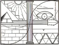
Maybe somebody can come up with an idea about this. The bottom peak (Culebra Peak) and the top of the T on Treasure Mountain, line up with the bottom of the eye figure. The second peak from the bottom (Spanish Peak) lines up with both corners of the eye. The third peak (Blanca Peak) lines up with the top of the eye. I think the eye might have some association with a treasure legend represented on the map. Have any of you folks ever heard of an eye symbolism associated with any of these legends, Beale, Oak Island, Wildcat Bluff, Spanish Peaks, Culebra Peak, Blanca Peak, Marble Mountain or Treasure Mountain?

Here's a carving placed in a position to form a 45-45-90 triangle with two other landmarks that surround an enormous treasure legend in NM.
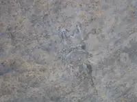
IMG_6182.webp


Now, to answer your specific question. Here's the same carving. It's located near Del Norte CO, surrounded by five of the sites you listed.
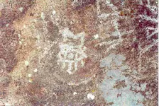
delnorte.webp
 

Here's a carving placed in a position to form a 45-45-90 triangle with two other landmarks that surround an enormous treasure legend in NM.

View attachment 1317458


Now, to answer your specific question. Here's the same carving. It's located near Del Norte CO, surrounded by five of the sites you listed.
View attachment 1317459

Thanks, Sdcfia. Do you know the exact location of the Egyptian rock by Del Norte?
 

Thanks, Sdcfia. Do you know the exact location of the Egyptian rock by Del Norte?

Unfortunately, no, but I believe it's just south of Del Norte a few miles. All information about this carving and many similar others in the western US is tightly held by the Ancient Historical Research Foundation. Mystery Glyphs - Home
 

Unfortunately, no, but I believe it's just south of Del Norte a few miles. All information about this carving and many similar others in the western US is tightly held by the Ancient Historical Research Foundation. Mystery Glyphs - Home

If it was located 6 miles at 120 degrees from Del Norte, you might be able to find the M above both eyes.....up by the Canadian border.
 

Here's a carving placed in a position to form a 45-45-90 triangle with two other landmarks that surround an enormous treasure legend in NM.

View attachment 1317458


Now, to answer your specific question. Here's the same carving. It's located near Del Norte CO, surrounded by five of the sites you listed.

View attachment 1317459

Panels with these symbols can be found throughout the SW United States. Primarily in Utah, but also Idaho, Colorado, Nevada, California, Arizona and New Mexico. Do a google search for "Mystery Glyphs" to find approximately 2 dozen panels where the above marker is a pretty common presence. If memory serves me many consider this to be a sort of signature for whomever placed the panels.
 

Panels with these symbols can be found throughout the SW United States. Primarily in Utah, but also Idaho, Colorado, Nevada, California, Arizona and New Mexico. Do a google search for "Mystery Glyphs" to find approximately 2 dozen panels where the above marker is a pretty common presence. If memory serves me many consider this to be a sort of signature for whomever placed the panels.

Yes, I posted that link in Post #23. I've had all the petroglyph photos and their general locations since Terry Carter first publicly released the information many years ago. There are various explanations for the "signature" symbol, including one among some AHRF supporters that it is that of the angel Moroni. I certainly don't agree with that allegation, although I do understand why it's on the AHRF table.

Interestingly, despite conflicting allegations on the origin of these mystery carvings, Carter has recently opined that they are 100-150 years old. I agree with that speculation at this time. There are clearly geographic associations between a number of these "mystery glyphs" and nearby treasure legends - legends that seem to have either surfaced, or have supposed historic links, during that time period. I'm aware of a number of these associations in UT, CO, AZ and NM. It would be interesting if somebody could find additional mystery glyph/treasure legend links in the other states.
 

If it was located 6 miles at 120 degrees from Del Norte, you might be able to find the M above both eyes.....up by the Canadian border.

I know for a fact that the specific location for at least one of these mystery glyph panels was chosen to create a near perfect geometrical shape, on a cardinal axis, with other well-known landmarks in the vicinity - landmarks with heavy treasure connotations.

I'm not sure what you're referring to re the Canadian border region, but I know there are other nodes up there that point to important things in the southwest. As you know, this stuff is all connected - and not by random chance.
 

lue map.webp

The thought that the eye carvings, with the M above it, could be some type of signature is very interesting. It would be good to know where the mystery glyphs, that have this carving on them, are located. There are three that I'm especially interested in close to Carson City and Virginia City, Nevada. If you notice the curved line that follows the arrow, from west to east, you will see that it touches the bottom line of the arrow twice. I believe this arrow represents a line that starts at Treasure Mountain, passes over Culebra Peak and then goes on to Wildcat Bluff, Arkansas. If you run that line backward to the Pacific Ocean, you will see that it goes right through the area of Carson City and Virginia City, which, I think, were gold producing areas. The LUE map might also be telling us where the gold or silver is coming from. You might also notice that the curved line disappears behind the column (Mississippi River) and then shows again on the east side of the column on the top line. If you take a straight edge and connect the lines on both sides of the column, you will see that the line would have intersected the line that I believe represents the Government Bridge at Rock Island, Illinois. This would go along with the link I posted about gold and silver from Virginia City going across Iowa on two different railroads, one of which includes the Government Bridge. You might also notice that the west end of the curved line starts a little ways in from the edge of the map. Maybe this represents the distance from the Pacific Ocean to the area of Carson City and Virginia City.

Up by Virginia City, it seems there are three of the mystery glyph stones, at Virginia City, Genoa, Nevada and Truckee, California. Could anybody tell us if the eye carvings are on these stones?
 

Last edited:
View attachment 1318050

The thought that the eye carvings, with the M above it, could be some type of signature is very interesting. It would be good to know where the mystery glyphs, that have this carving on them, are located. There are three that I'm especially interested in close to Carson City and Virginia City, Nevada. If you notice the curved line that follows the arrow, from west to east, you will see that it touches the bottom line of the arrow twice. I believe this arrow represents a line that starts at Treasure Mountain, passes over Culebra Peak and then goes on to Wildcat Bluff, Arkansas. If you run that line backward to the Pacific Ocean, you will see that it goes right through the area of Carson City and Virginia City, which, I think, were gold producing areas. The LUE map might also be telling us where the gold or silver is coming from. You might also notice that the curved line disappears behind the column (Mississippi River) and then shows again on the east side of the column on the top line. If you take a straight edge and connect the lines on both sides of the column, you will see that the line would have intersected the line that I believe represents the Government Bridge at Rock Island, Illinois. This would go along with the link I posted about gold and silver from Virginia City going across Iowa on two different railroads, one of which includes the Government Bridge. You might also notice that the west end of the curved line starts a little ways in from the edge of the map. Maybe this represents the distance from the Pacific Ocean to the area of Carson City and Virginia City.

Up by Virginia City, it seems there are three of the mystery glyph stones, at Virginia City, Genoa, Nevada and Truckee, California. Could anybody tell us if the eye carvings are on these stones?

I have photos for the Genoa and Truckee sites, but neither shows the eye carving on them. I don't know whether my photos contain all the carvings at these sites.
 

Tonight, I will show you how the straight line method, that I've been posting, can be used to find treasure. I'm going to put this information out there for everybody to see. The information I give you will show you the location of a vault and gold bullion that has never been recovered.

There are two important lines that I have mentioned in this thread. You can plot both of them on google earth. One line is shared by two of the large triangles that I have mentioned in an earlier post. The first line goes from Apple Lake, in Becker County, Minnesota, to Springfield, Georgia. The second line goes from Treasure Mountain, Mineral County, Colorado to Villamont, Virginia. The vault is located a couple miles south of the place where the two lines intersect. I know this place has active sentinels and a recovery will never be made.
 

Last edited:
mdog the info on the excerpt from Lafayette C. Baker, is very interesting
had a convo, with 2 guys in fla. in the 80s (my 1st time hearing about the map)
they thought of it as a cryptic rebus and prob civil war related.


Randy Bradford said I could post this info on his Treasure Mountain thread, but I decided to start a new one. I'm not going to go into a lot of detail unless somebody asks and then I'll be happy to.

Here's the LUE map that I'll use.

View attachment 1316353

Here's an excerpt that I found about Lafayette C. Baker, a Union spy during the Civil War, and how he processed information.

Baker had a system devised which eliminated the need for written words and maps. He memorized them. He could but others couldn't. He would divide a map into four segments of equal size and then determine the important segments. He would then concentrate on the important segments. He would draw mental lines diagonally cross the segments and then refer everything to these lines and their point of intersection, referring to everything in kilometers and degrees of [a] compass. He would then remember the two sets of numbers. He could retain up to fifty sets of numbers and transpose them back onto a map of different scale some two to five days later with no error. Once he met someone he could always call them by name on the next meeting. He was, without doubt, a genius.

I thought this was interesting because the LUE map is divided into four parts.


Good luck to all those who are seeking this treasure.
 

Tonight, I will show you how the straight line method, that I've been posting, can be used to find treasure. I'm going to put this information out there for everybody to see. The information I give you will show you the location of a vault and gold bullion that has never been recovered.

There are two important lines that I have mentioned in this thread. You can plot both of them on google earth. One line is shared by two of the large triangles that I have mentioned in an earlier post. The first line goes from Apple Lake, in Becker County, Minnesota, to Springfield, Georgia. The second line goes from Treasure Mountain, Mineral County, Colorado to Villamont, Virginia. The vault is located a couple miles south of the place where the two lines intersect. I know this place has active sentinels and a recovery will never be made.

Ha ha - good one, mdog. Real good. Ha ha.
 

I didnt look for the lines that cross,but from the responses,it makes me think its Fort Knox.
 

I know for a fact that the specific location for at least one of these mystery glyph panels was chosen to create a near perfect geometrical shape, on a cardinal axis, with other well-known landmarks in the vicinity - landmarks with heavy treasure connotations.

I'm not sure what you're referring to re the Canadian border region, but I know there are other nodes up there that point to important things in the southwest. As you know, this stuff is all connected - and not by random chance.

I remember reading about that amazing layout in New Mexico Confidential. And the story that goes along with it is really interesting and one that I had never heard of until I read the book.

The place by the Canadian border is one that you have mentioned before, the International Peace Garden. Just below the Canadian border is a lake shaped like an M. Starting there and heading toward the Egypt stone, described in New Mexico Confidential, you run pretty close to Del Norte. That would be two mystery stones with an eye carved on them and an M above the eye. I think there was another mystery stone by Lordsburg, New Mexico, which would also line up well with the other two stones. I wonder if the signature eye with M is on the Lordsburg stone?
 

mdog the info on the excerpt from Lafayette C. Baker, is very interesting
had a convo, with 2 guys in fla. in the 80s (my 1st time hearing about the map)
they thought of it as a cryptic rebus and prob civil war related.

cw0909, yes, It was an interesting story about Baker. I'd like to see another map similar to the LUE that could be used for a comparison.
 

:laughing7: I knew my research would eventually lead me to something of value. :occasion14:

Let's see.... maybe about 250 billion dollars. Does this qualify as the biggest treasure find of all time? :hello2: :laughing7:
 

Top Member Reactions

Users who are viewing this thread

Back
Top Bottom