Something New About the LUE

mdog

Bronze Member
Mar 22, 2011
2,340
4,395
Randy Bradford said I could post this info on his Treasure Mountain thread, but I decided to start a new one. I'm not going to go into a lot of detail unless somebody asks and then I'll be happy to.

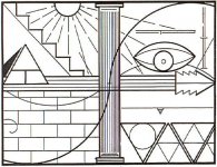
Here's the LUE map that I'll use.

lue map.jpg

Here's an excerpt that I found about Lafayette C. Baker, a Union spy during the Civil War, and how he processed information.

Baker had a system devised which eliminated the need for written words and maps. He memorized them. He could but others couldn't. He would divide a map into four segments of equal size and then determine the important segments. He would then concentrate on the important segments. He would draw mental lines diagonally cross the segments and then refer everything to these lines and their point of intersection, referring to everything in kilometers and degrees of [a] compass. He would then remember the two sets of numbers. He could retain up to fifty sets of numbers and transpose them back onto a map of different scale some two to five days later with no error. Once he met someone he could always call them by name on the next meeting. He was, without doubt, a genius.

I thought this was interesting because the LUE map is divided into four parts.


OP
OP
M

mdog

Bronze Member
Mar 22, 2011
2,340
4,395
I have concentrated my research on North American geography, place names, geometric patterns, treasure legends and the geography associated with them, and point to point great circle plotting. I've written about some of this stuff in my KGC thread, Things For Further Research. I'm not trying to convince anybody that my interpretation is the right one. It's information that I have found and if you can use it, good luck. Here's the map.

lue map.jpg

The bottom right hand quarter dates the map to the early 20th century. The three large triangles represent three regions that include most of the United States. The perimeter of the west one is 3797 miles, the center one is 4033 miles and the east one is 3834 miles. The imaginary boundaries include places that are associated with treasure legends. The small triangle beneath the horizontal line is what dates the map to the early 20th century. The triangle has three sides and three sections within it. It is 90 miles from the south tip of the small triangle to the north tip of the large center triangle. Most of the precious metals found in the US were found in the region that includes the west triangle on to the Pacific coast.
 

OP
OP
M

mdog

Bronze Member
Mar 22, 2011
2,340
4,395
lue map.jpg

I believe the five steps represent five mountains in Colorado that are by the San Luis Valley, Marble Mountain, Black Mountain, Blanca Peak, Spanish Peak East and Culebra Peak. These mountains form a design similar to the constellation Auriga. If you break down Auriga into two parts, AU and RIGA, you get a meaning of gold line. There are five parallel lines in the arrow shape. I believe the triangle with the T represents Treasure Mountain. A shadow is on the west side so the sun would be in the east and the five peaks in the Auriga formation are between the sun and Treasure Mountain. If you get on google earth and start a line at Treasure Mountain you can run lines to the treasure legend sites of Oak Island, Villamont, Virginia (Beale treasure) and Wildcat Bluff, ARK (KGC legend). After running these lines, you will see that they pass over Marble Mountain, Blanca Peak and Culebra Peak.
 

OP
OP
M

mdog

Bronze Member
Mar 22, 2011
2,340
4,395
lue map.jpg

You will notice that the base of Treasure Mountain rests on the center line that goes to Villamont, Virginia, which is represented by the bold V at the point of the arrow. Here is how those two places are connected. The latitude of Villamont, Virginia is 37deg 23' 42.85". The latitude of Treasure Mountain is 37deg 27' 20.37". That's a difference of 4.26 miles over a distance of 1500 miles, that's close. Also, you can't move a mountain to make things line up. The first mention that I can find of the town name Villamont is 1915.
 

Rebel - KGC

Gold Member
Jun 15, 2007
21,680
14,739
View attachment 1316399

You will notice that the base of Treasure Mountain rests on the center line that goes to Villamont, Virginia, which is represented by the bold V at the point of the arrow. Here is how those two places are connected. The latitude of Villamont, Virginia is 37deg 23' 42.85". The latitude of Treasure Mountain is 37deg 27' 20.37". That's a difference of 4.26 miles over a distance of 1500 miles, that's close. Also, you can't move a mountain to make things line up. The first mention that I can find of the town name Villamont is 1915.
Villamont, Va. was once known as IRONVILLE, Va.; very nice area...
 

OP
OP
M

mdog

Bronze Member
Mar 22, 2011
2,340
4,395
lue map.jpg

There are 11 lines inside the column and 11 triangles and partial triangles to the east of the west large triangle. I believe the column represents the Mississippi River and the lines inside the column represent the 11 triangles and partial triangles. I believe the bottom bold line on the arrow represents St. Louis where it crosses the column. I believe the spaces between the parallel lines on the arrow represent 100 miles.
 

OP
OP
M

mdog

Bronze Member
Mar 22, 2011
2,340
4,395
lue map.jpg

Now for the upper right quarter. Maine is the pine tree state. There are two bars, one horizontal and the other vertical. The horizontal bar is divided into three segments and the vertical bar is divided into five. Go to google earth and look at the border lines between New York, Vermont and Canada. Now look at the eastern border of New Hampshire. There are your two bars. Notice the ray of the sun goes to the right side of the horizontal bar. Go to the junction of the Canada, New York and Vermont borders and start a line. Run that line to the Vermont-New Hampshire border and keep going east to the east coast of Nova Scotia and mark that trail. Go to the money pit on Oak Island and start a line and run it up 360 deg to the east-west line from Maine. The distance should be about 15.5 miles. The bars had 3 segments and 5 segments, 3x5=15.
 

OP
OP
M

mdog

Bronze Member
Mar 22, 2011
2,340
4,395

Attachments

  • lue map.jpg
    lue map.jpg
    60.9 KB · Views: 248

Randy Bradford

Hero Member
Jun 27, 2004
504
891
Some interesting interpretations...I wish I had my notes handy. In particular is a very old article that described some similar interpretations as your own, notably that the map represented the United States although I think that writer (not KvM) felt the pyramid represented the Rocky Mountains if memory serves me. They also felt the two sine waves represented the Colorado and Rio Grande Rivers (likewise, if memory serves me correctly).


Mdog, assuming your interpretations are correct, do you feel any specific treasure sites are denoted with the map?
 

sdcfia

Silver Member
Sep 28, 2014
3,657
8,879
Primary Interest:
Other
Two hundred straight line miles north of old St. Louis, the site of the arch, is this railroad bridge.

https://en.wikipedia.org/wiki/Government_Bridge the government bridge at Rock Island, Ill. It was on one of the two railroads that moved bullion across Iowa from points west.

Boone County History: Stagecoaches and railroads transfer silver and gold | Boone News-Republican

Very intriguing stuff, mdog. I know that for years now you have worked backward from Muscatine and connected a lot of historical dots to Wildcat Den. And from there, interestingly, possibly to the LUE map. If your ideas about the LUE map are correct, then it may be less of a "treasure map" and more of a record of transfer for a west-to-east bullion movement. That means that if there was more than one transfer, then all or some of the four quarters of the map ought to vary with each origin and destination. If so, then we might expect that there are more similar but different "LUE maps" out there somewhere.

Of course, KvM is the wild card in all this LUE business, and by definition, first and foremost, his motives and actions are subject to serious scrutiny, IMO. Also of course is the timing of the original introduction of the map - 1930s, wasn't it? Be all that as it may, if there is hidden treasure associated with the current LUE map, we don't know where it came from, where it is now, who hid it or who controls it. I for one am skeptical about the various recoveries claimed by folks. When you think about it, the same can be said for several "treasure legends."
 

OP
OP
M

mdog

Bronze Member
Mar 22, 2011
2,340
4,395
Very intriguing stuff, mdog. I know that for years now you have worked backward from Muscatine and connected a lot of historical dots to Wildcat Den. And from there, interestingly, possibly to the LUE map. If your ideas about the LUE map are correct, then it may be less of a "treasure map" and more of a record of transfer for a west-to-east bullion movement. That means that if there was more than one transfer, then all or some of the four quarters of the map ought to vary with each origin and destination. If so, then we might expect that there are more similar but different "LUE maps" out there somewhere.

Of course, KvM is the wild card in all this LUE business, and by definition, first and foremost, his motives and actions are subject to serious scrutiny, IMO. Also of course is the timing of the original introduction of the map - 1930s, wasn't it? Be all that as it may, if there is hidden treasure associated with the current LUE map, we don't know where it came from, where it is now, who hid it or who controls it. I for one am skeptical about the various recoveries claimed by folks. When you think about it, the same can be said for several "treasure legends."

I'm thinking along the lines that the map represents bullion transfer from west to east. An important question is, who created the map? If the map represents the geography I've described, there was a lot of time and effort put into the project. It would have involved many people and extended over a period of decades. Also, was the map created to protect against a robbery, or was it to show where a robbery could be made and where to take the stolen bullion. I've mentioned to you how it might be possible to switch silver bullion for gold with little risk of discovery, but inside help would be required.

The 1930's and the two decades leading up to it would be my guess. There seemed to be a flurry of activity, leading up to the 30,s, when some areas were abandoned and others acquired. It would be nice to find a similar map.
 

OP
OP
M

mdog

Bronze Member
Mar 22, 2011
2,340
4,395
Some interesting interpretations...I wish I had my notes handy. In particular is a very old article that described some similar interpretations as your own, notably that the map represented the United States although I think that writer (not KvM) felt the pyramid represented the Rocky Mountains if memory serves me. They also felt the two sine waves represented the Colorado and Rio Grande Rivers (likewise, if memory serves me correctly).


Mdog, assuming your interpretations are correct, do you feel any specific treasure sites are denoted with the map?

If the map were used for clandestine purposes, I think the best place for a recovery would be spots along the Mississippi River that are little known and where stolen bullion could be accumulated for concealment or distribution. You would have to figure out how far from St. Louis the accumulation points were and then begin looking for a needle in a haystack. I think it would be an impossible task. Something else, I'm pretty sure that any valuable metals from this effort are presently owned and not lost or forgotten about, so any attempt at recovery would be a criminal action and could have consequences. It's also just my opinion that the old cache sites have been sold or donated to the public and that the present sites, if there are any, would probably be on corporate property. Just my opinion and that, along with a dime, isn't worth anything.
 

OP
OP
M

mdog

Bronze Member
Mar 22, 2011
2,340
4,395
lue map.jpg

I'm going to go into more detail about the three big triangles, and the small triangle above them, that are shown in the lower right quarter of the map. I'll copy and paste some of the information from my KGC thread, Things For Further Research.

The Kensington Runestone is important to these triangles.

https://en.wikipedia.org/wiki/Kensington_Runestone

Since it was found, there have been people who have said that the carvings on the stone were a hoax and there have been others who say the stone is genuine and was carved by Norse explorers in 1362. I was more interested in the placement of the stone, why was it put where it was? At first I thought it was a random placement carved at the scene and left where it was carved. But after spending a lot of time researching the area and looking for any important Indian trails, I decided to check out the latitude of the site where the stone was found and see if anything jumped out at me. Scott Wolter has written a couple books about the stone and one of them showed the site where the stone was found. The latitude of the recovery site is 45 deg 48' 38" and the longitude is 95 deg 39' 38". Get on google earth and mark the stone's latitude on the east border of Maine and the west border of Washington state. Remember the number 1362 at the end of the runes. Run a line from the Kensington site to the west latitude of the runestone, it should be about 1360 miles. Now run a line to the east latitude of the runestone, it should be about 1339 miles. But, the old border of Maine was further east from the present boundary. I've not had any luck finding the longitude of the old boundary but from looking at a couple of old maps, the longitude seems to be around 67 deg 17' 53". That would make the miles from the Kensington stone a lot closer to 1362, almost exact.

The runestone latitude formed the top three points of the three triangles, there was no gap between the imaginary borders, so the two inside borders were shared. This northern part of the triangles could have been created during the late 1700's or early 1800's, before Maine's eastern border was shared. The layout for the triangles was probably completed at some time after the Civil War up to 1898, when the runestone was found.

The bottom two points could have been Capitan Mountain in Lincoln County, New Mexico and Muscadine, Alabama. Capitan Mountain would have been the last point plotted.

This would give you three triangles with the following measurements, west triangle-1360 miles, 1295 miles and 985 miles. Central triangle would be- 985 miles, 995 miles and 1148 miles. East triangle would be 1362 miles, 1268 miles and 995 miles.

This would have been the first setup. The second one was plotted after 1898.
 

OP
OP
M

mdog

Bronze Member
Mar 22, 2011
2,340
4,395
lue map.jpg

Here is how I think the three large triangles were plotted after 1898. It could be that the English translation of the runestone was used to create a new northern boundary.

Here is a Wikipedia translation of the stone.

"Eight Götalanders and 22 Northmen on (this?) acquisition journey from Vinland far to the west."

"We had a camp by two (shelters?) one day's journey north from this stone."

One days journey is usually considered to be about 20 miles. I was looking for some type of code that could be used so I decided to use 24 hours, a full day, and 4 miles per hour, a distance that can be covered in an hour but probably not maintained. This would make the miles covered in a day, 96. At 352.10 degrees north of the KRS and 96 miles exact is the small town of Waubun. This line from the KRS also runs through Ogema. Both names are from the Ojibwe language. Ogema means "chief" and Waubun means "the east", "the morning", "the twilight of dawn". These two towns are the points that define the east side of an almost perfect equilateral triangle. These two towns would be the new representation of "two shelters one day's journey north of this stone."

"We were fishing one day."

The new site would need a lake or some other body of water where men could fish. The west point of the triangle is on the east side of Apple Lake at a spot where a long line, formed by two points hundreds of miles to the southeast, touches Apple Lake.

"After we came home, found 10 men red from blood and dead. Ave Maria save from evil."

I think this confirms the points of the east line. "red from blood and dead" In Waubun there is a Saint Anne's Cemetery. There are two colors associated with Saint Anne, red and green. "Ave Maria save from evil". There is a Catholic Church in Ogema named Most Holy Redeemer Catholic Church. A redeemer is one who could "save from evil".

"There are 10 men by the inland sea to look after our ships fourteen days journey from this peninsula (or island). Year 1362"

I think this line is to confirm the connection with the KRS. "fourteen days journey from this peninsula" 14 days X 24 hours per day= 336 hours X 4 mph= 1344 miles. There is a peninsula formed on the south side of Apple Lake. If you run a line from the top middle of that peninsula to the place on the eastern Maine border that has the exact latitude of the KRS, you have 1343.77 miles. That spot is also in the middle of Grand Lake which is a pretty good sized lake or "inland sea".

The sides of the triangle are 5.51 miles, 5.47 miles and 5.78 miles.

Here's something else. The latitude at the top of the peninsula at Apple Lake is 47 deg 08' 54". Mark this latitude on the west border of Washington state and the east border of Maine. The distance from Apple Lake to the Maine latitude is 1318 miles. From Apple Lake to the Washington latitude is 1319 miles.

Ogema and Waubun were not established until 1907. This is well after the KRS was found in 1898.

This would give the three northern points of the large triangles. The two southern points would be Silver City, New Mexico and Springfield, Georgia. Springfield, Georgia would have been the last point plotted.

The measurements of these three new triangles would have been, west triangle-1319 miles, 1296 miles and 1182 miles. Center triangle-1182 miles, 1281 miles and 1570 miles. East triangle-1318 miles, 1281 miles and 1240 miles.

I think the bottom right quarter of the LUE map shows the small Apple Lake triangle above the three large triangles with the Kensington Runestone site at the center.

You might also notice that the Apple Lake triangle is north and just to the west of the runestone point, same as what is shown on the LUE map. Also, the small Lue triangle has three sides and is divided into three sections, this gives you two 3's. From the bottom point of the Apple Lake triangle to the Kensington site is 90.48 miles.
 

OP
OP
M

mdog

Bronze Member
Mar 22, 2011
2,340
4,395
lue map.jpg

There's something else that I would like to bring up about the southern base of the three large triangles. The old triangle base was from Capitan Mountain, New Mexico to Muscadine, Alabama. If you go to google earth and start a line at Capitan Mountain and run it east to Muscadine, The degree you see in the distance box will be 83.97 degrees. If you then go to the new triangle base an start a line at Silver City, New Mexico and run it to Springfield, Georgia, the degree you will see in the distance box will be 83.63 degrees. I've found that a west to east reading of 85 degrees pops up pretty often in these treasure related sites. Steve Clark wrote about an example of this in his book New Mexico Confidential.
 

sdcfia

Silver Member
Sep 28, 2014
3,657
8,879
Primary Interest:
Other
The Capitan Mountain NM mention is interesting. There is a treasure legend associated with that range, but very little information has surfaced. Allegedly, there is some sort of cave with steps leading to a hidden Aztec hoard. I believe the Capitan Range is the only east-west aligned range of mountains in the US.

There's apparently also some woo-woo goings on there: https://books.google.com/books?id=4...age&q=capitan mountain aztec treasure&f=false
 

OP
OP
M

mdog

Bronze Member
Mar 22, 2011
2,340
4,395
The Capitan Mountain NM mention is interesting. There is a treasure legend associated with that range, but very little information has surfaced. Allegedly, there is some sort of cave with steps leading to a hidden Aztec hoard. I believe the Capitan Range is the only east-west aligned range of mountains in the US.

There's apparently also some woo-woo goings on there: https://books.google.com/books?id=4...age&q=capitan mountain aztec treasure&f=false

Thanks for the link. That was a very unusual story. But, it's the most information I've read about that area.

Did the fire ever burn itself out?
 

OP
OP
M

mdog

Bronze Member
Mar 22, 2011
2,340
4,395
lue map.jpg

Here is another thought that could show a connection between Treasure Mountain and Villamont, Virginia (Beale legend). The top of the pyramid lines up with the third peak which would be Blanca Peak and when you run a line from Treasure Mountain to Villamont, Virginia, the line passes over Blanca Peak. So, the bottom of the pyramid is on the third line which goes over Blanca Peak to Villamont, and the top of the pyramid lines up with the third peak, which is Blanca Peak, and the gold line that connects Treasure Mountain to Villamont goes over Blanca Peak.
 

OP
OP
M

mdog

Bronze Member
Mar 22, 2011
2,340
4,395
lue map.jpg

Maybe somebody can come up with an idea about this. The bottom peak (Culebra Peak) and the top of the T on Treasure Mountain, line up with the bottom of the eye figure. The second peak from the bottom (Spanish Peak) lines up with both corners of the eye. The third peak (Blanca Peak) lines up with the top of the eye. I think the eye might have some association with a treasure legend represented on the map. Have any of you folks ever heard of an eye symbolism associated with any of these legends, Beale, Oak Island, Wildcat Bluff, Spanish Peaks, Culebra Peak, Blanca Peak, Marble Mountain or Treasure Mountain?
 

sdcfia

Silver Member
Sep 28, 2014
3,657
8,879
Primary Interest:
Other
Thanks for the link. That was a very unusual story. But, it's the most information I've read about that area.

Did the fire ever burn itself out?

Yeah, see Post #89 in the LAD thread.
 

Top Member Reactions

Users who are viewing this thread

Top