Something New About the LUE

I remember reading about that amazing layout in New Mexico Confidential. And the story that goes along with it is really interesting and one that I had never heard of until I read the book.

The place by the Canadian border is one that you have mentioned before, the International Peace Garden. Just below the Canadian border is a lake shaped like an M. Starting there and heading toward the Egypt stone, described in New Mexico Confidential, you run pretty close to Del Norte. That would be two mystery stones with an eye carved on them and an M above the eye. I think there was another mystery stone by Lordsburg, New Mexico, which would also line up well with the other two stones. I wonder if the signature eye with M is on the Lordsburg stone?

As you well know, mdog, when you connect two sites with a straight line on GE, that line often crosses other intriguing sites, sometimes precisely. Coincidence or ...? Of course, the key is choosing your starting and ending points for the line. There are some amazing correspondences when you line up locations from the International Peace Garden. There are two starting points there for running your lines, the first being the octagonal fountain on the US/Canadian border. Carefully choose corners, edges, midpoints, etc. to begin your alignments, then extend them to a distant location (which is the key because it requires that you have an idea of where the line goes to begin with). There are unlimited possibilities, and this is where your knowledge, research, experience and hunches counts. Thanks for the info on that M-shaped lake - I'll have to play around with it.

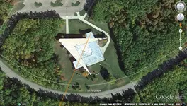
A mile south of the IPG fountain is the building pictured below. Does the shape of the building look familiar? You can see how I aligned the orange line to opposite corners of the Masonic square. When you extend this line far enough, it ends at the top of a little place called Big Lue Mountain. Interesting, no?
ipg.webp

I haven't located the Lordsburg mystery glyphs yet. Even though years ago I guided three members of the AHRF to the Silver City glyphs so that they could better document those carvings, they refused to tell me where the Lordsburg carvings were located. So much for favors, huh?
 

Let's see.... maybe about 250 billion dollars. Does this qualify as the biggest treasure find of all time? :hello2: :laughing7:

Yeah, but what if it's just an IOU?
 

Yeah, but what if it's just an IOU?

....If that's the case.....I intend to donate the entire contents of the vault to the people of the United States of America. :hello2: :occasion14: :thumbsup:
 

As you well know, mdog, when you connect two sites with a straight line on GE, that line often crosses other intriguing sites, sometimes precisely. Coincidence or ...? Of course, the key is choosing your starting and ending points for the line. There are some amazing correspondences when you line up locations from the International Peace Garden. There are two starting points there for running your lines, the first being the octagonal fountain on the US/Canadian border. Carefully choose corners, edges, midpoints, etc. to begin your alignments, then extend them to a distant location (which is the key because it requires that you have an idea of where the line goes to begin with). There are unlimited possibilities, and this is where your knowledge, research, experience and hunches counts. Thanks for the info on that M-shaped lake - I'll have to play around with it.

A mile south of the IPG fountain is the building pictured below. Does the shape of the building look familiar? You can see how I aligned the orange line to opposite corners of the Masonic square. When you extend this line far enough, it ends at the top of a little place called Big Lue Mountain. Interesting, no?

View attachment 1319409

I haven't located the Lordsburg mystery glyphs yet. Even though years ago I guided three members of the AHRF to the Silver City glyphs so that they could better document those carvings, they refused to tell me where the Lordsburg carvings were located. So much for favors, huh?

KABOOM!!! I think you just established a Treasure Mountain-Masonic link. I think I had a post that mentioned activity during the late 1920's and early 1930's to acquire certain property around the United States. The Peace Garden and the memorial where the St. Louis Arch stands were two of them. If you run lines between those two places and Treasure Mountain, you get a triangle with sides of 867.48 miles, 865.10 miles and 909.94 miles. Then, if you check out the angles of the triangle at those three places, you get 63.61 degrees at the Peace Garden, 58.72 degrees at the St. Louis Arch and 58.91 degrees at Treasure Mountain. Also, in my other research, I have found that, when you have an almost perfect equilateral triangle, a place of value is at the lower left angle and that would be Treasure Mountain. Also, with the connection you made with the Big Lue Mountain in Arizona, you might have also proven a link between the Treasure Mountain and LUE legends. Great job.
 

If you guys find any lines that hit in the mountains my way, and you want to see whats there let me know, ill do a photo recon for you.:thumbsup:
 

If you guys find the 250 billion treasure - please let me know. I'd be more than happy to take it off your hands ....

ok ok - just yankin' ya chain!~
 

If you guys find the 250 billion treasure - please let me know. I'd be more than happy to take it off your hands ....

ok ok - just yankin' ya chain!~

The vault has been pinpointed.....recovery could be a problem. :laughing7:
 

# 46, Loke, too bad, the federal government will beat you in take the whole treasures. Good hunting and good luck.
 

lue map.webp

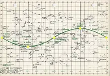
star chart 700.webp

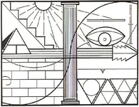
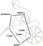
It has been mentioned in other posts that the curved line along the arrow could represent a star chart. Here's a star chart that Randy put in one of his posts from last year. It's easy to see the similarity between the two curves. If you look at the placement of the eye on the LUE map, you will see that it is at the summer solstice position. Just above the sun of the summer solstice is the constellation Auriga (gold line). The eye might have been put in that position to alert the reader that the five peaks of the Auriga setup were to be considered. I've been trying to find something on the map that would show an Auriga connection and maybe this is it.
 

star chart crop 700.webp

Here's a closeup showing Auriga.
 

Here's a simple picture of the Auriga Constellation.

auriga.webp


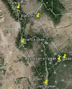
Here is a google earth picture showing the Auriga setup in Colorado using mountains associated with treasure legends. Treasure Mountain is to the west of these mountains.

map 500 t.webp

The peak on the right edge is East Spanish Peak.

As far as I know, there is no legend involving Black Mountain. Black Mountain is at the Capella spot which may or may not have some significance.
 

Last edited:
Randy Bradford said I could post this info on his Treasure Mountain thread, but I decided to start a new one. I'm not going to go into a lot of detail unless somebody asks and then I'll be happy to.

Here's the LUE map that I'll use.

View attachment 1316353

Here's an excerpt that I found about Lafayette C. Baker, a Union spy during the Civil War, and how he processed information.

Baker had a system devised which eliminated the need for written words and maps. He memorized them. He could but others couldn't. He would divide a map into four segments of equal size and then determine the important segments. He would then concentrate on the important segments. He would draw mental lines diagonally cross the segments and then refer everything to these lines and their point of intersection, referring to everything in kilometers and degrees of [a] compass. He would then remember the two sets of numbers. He could retain up to fifty sets of numbers and transpose them back onto a map of different scale some two to five days later with no error. Once he met someone he could always call them by name on the next meeting. He was, without doubt, a genius.

I thought this was interesting because the LUE map is divided into four parts.


=========================================
I see a LOT of VERY OLD math concepts in this "map".
Without going into a book of detail,,, EXACTLY what are YOUR opinions of the origins of it?
I will tell mine after I read yours.
 

=========================================
I see a LOT of VERY OLD math concepts in this "map".
Without going into a book of detail,,, EXACTLY what are YOUR opinions of the origins of it?
I will tell mine after I read yours.

It's just my opinion that, if the map represents the geography and the geometry that I've been describing, it originated with some Masonic group, probably not the Masons as an organization, but a group familiar with Masonic activities. I would guess that the map was drawn at some time between 1920-1935, that's assuming that the map was created to record the movement or concealment of bullion. BUT, if just one person knew the geography, that person could have drawn out the map the day before it was made public. I could make a similar map using the same geography.

I believe the effort to create the geography began during the late 1700's and involved a great number of Masons. As our country expanded and land surveys were continually recorded, the effort grew to include cooperation at the county, state and national levels. I believe there was a flurry of activity during the late 1800's and early 1900's, probably some fine tuning. This stuff has been written about before. It's pretty easy to spot if you spend the time to look for the evidence on the maps and study the history of the locations.
 

Eh...? Try Stella Theology & Masonic Astrology... 1882.
 

Hi mdog , my apologies to you for not having the time to participate in this most fascinating thread you guys have going on .I have a question for you if it does not take to much of your time that is . Using your star map/ cappella postion on the ground for the summer solstice.could someone with your talents plot the location of these stars on the ground during the night of the summers opposite or where these constellations would be on The night of the winter solstice? I hope I have made sense with this request . Things are just seldom as they appear on the surface with this
Treasure stuff it seems , and I have this puzzle I've been working on for thirty or forty years that keeps coming up every time you bring this and stuff up. :icon_thumright:

You know now that I think about it maybe you have already done all the work and the only thing left to do would be to use your postions from modern times and this map you have already given for the summer set up as the key reference and simply over lay the winter constilations from old .the problem I have had with my little science project is not stars moving around . More like the earth screaming through the Galaxy for eons.lol


All that masonic stuff
As above so below ..
All things have an opposite....
Seasons , Time ,

Awe heck I'm just guessing ,,,,,,, a little game I play called where in the vast endlessness of space was Orion.NIGHT SKY~WINTER HEXAGON
 

Last edited:
Oooop PS I meant to type Auriga. Not cappella .... sorry. I guess I'm really typing in code, here I hope your a good mind reader :BangHead:
Lol
 

Top Member Reactions

Users who are viewing this thread

Back
Top Bottom