Blindbowman
Bronze Member
- Joined
- Aug 15, 2007
- Messages
- 2,077
- Reaction score
- 1,013
- Golden Thread
- 0
- Primary Interest:
- All Treasure Hunting

 ?
? 

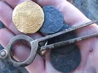
very true my friend ...i have uses this type before ,and they are very very hard and can be re sharpend dozen and dozen of times ..they are also razor needel sharp ...and can be sharpend with a common wet stone ..Real de Tayopa Tropical Tramp said:HI Beth, those are probably old shipboard dividers, They were made sturdier by using that curved section for extra support. On an old sailing ship, pitching and rolling, it would be all too easy to spring a standard type.
Don Jose de La Mancha


“Wise men speak because they have something to say; Fools speak because they have to say something.”

shadow hunter said:what leads you to the conclusion that those are what the tool of choice was when making this map? let's hear some thoughts behind this?
EE THr said:I don't think that being sharp had a lot to do with the quality or accuracy of dividers back then, because who would want to poke holes in their maps?
Even "modern" use of navagation dividers include the use of glass or plexi over the map, and a grease pencil to mark your sightings and course with, so they can be erased, and to protect the map.
shadow hunter said:Good point EE THr and Beth....
plus the odds of the person who made the map having that particular kind of instrument is highly unlikely. I am not saying he/she did not have something similar, but the high quality, sea mapping kind is kinda a far fetch. also, anyone that mad maps out in the sea rely heavily on the stars and the time of year, these maps don't really give that kind of indication. I think BB it was a valient attempt, but i don't think anyone is buying into that theory. I don't have a theory on how they were made, but you know the old saying, “Wise men speak because they have something to say; Fools speak because they have to say something.”
Blindbowman said:shadow hunter said:Good point EE THr and Beth....
plus the odds of the person who made the map having that particular kind of instrument is highly unlikely. I am not saying he/she did not have something similar, but the high quality, sea mapping kind is kinda a far fetch. also, anyone that mad maps out in the sea rely heavily on the stars and the time of year, these maps don't really give that kind of indication. I think BB it was a valient attempt, but i don't think anyone is buying into that theory. I don't have a theory on how they were made, but you know the old saying, “Wise men speak because they have something to say; Fools speak because they have to say something.”
do some research before you reply ,, you are wrong again "anyone that mad maps out in the sea rely heavily on the stars and the time of year"
where did you get this idea .. its out right wrong .
shadow hunter said:Blindbowman said:shadow hunter said:Good point EE THr and Beth....
plus the odds of the person who made the map having that particular kind of instrument is highly unlikely. I am not saying he/she did not have something similar, but the high quality, sea mapping kind is kinda a far fetch. also, anyone that mad maps out in the sea rely heavily on the stars and the time of year, these maps don't really give that kind of indication. I think BB it was a valient attempt, but i don't think anyone is buying into that theory. I don't have a theory on how they were made, but you know the old saying, “Wise men speak because they have something to say; Fools speak because they have to say something.”
do some research before you reply ,, you are wrong again "anyone that mad maps out in the sea rely heavily on the stars and the time of year"
where did you get this idea .. its out right wrong .
please enlighten me sir. because from what i have been taught is maps were made at sea by using the stars. Sailors measured the position of the stars above the horizon using a sextant, from a table of known postions of the stars. they also had to know what time of year and what time of day it was, this was taken from a known point at Greenwich in England (Greenwich Mean Time GMT). Every place on earth takes its time from being plus or minus so many hours from GMT. If you could please tell show me the other methods used i would be more then happy to learn something new. well, let me clarify, I would be happy to learn something new if it had some truth behind it then a wild eyed theory.
Real de Tayopa Tropical Tramp said:Good morning: I have to partially side with BB on this. Maps were made on shore with the accumulated data from the pilots of that time. The first crude attempts to measure Celestial bodies 'prob'. came in the 1600's using astrolabes. The later refinement of using a sextant required an accurate time piece as suggested by Shadow. The usual needed position correction, came with the normal noon day sun shot, or Moon shot which when used with reference to the time piece adjusted to Greenwich, gave a fairly accurate location . The accumulated data from many pilots logs was then transferred to the charts.
Geeze, it has been so long since I did any celestial navigation that I am a bit rusty on my historical and actual memories, so don't shoot me if I am a bit off.
Don Jose de La Mancha
shadow hunter said:BB
interesting site, like they say.....you learn something new everyday, and that was mine today. I do see where you are coming from on how they navigated then, and i can see your point. I still don't buy into the fact that you think the stones were carved with such an instrument, but i can see how you may suggest that as a theory. i do have a question though, let's say that they did use dividers to carve the map, and as they dulled they had to resharpen them. would it be safe to say that the carvings would indicate that by showing some places that are more dull and rounded in the stone, opposed to a newly sharpened tool that would leave a deeper sharper cut in the stone. so presumably the stones carvings would have different styles of cuts on them depending on the sharpness of the tool used?
shadow hunter