What's new

What happened to the Kidd-Palmer treasure maps?

Maybe of interest to you all regarding the above and the (Failed)Captain Studdard expedition. He sent the 'parchment' to the Home Office forensic Science laboratory in August 1951. I have the report, the parchment in question was the first chart found in the Bureau. They of course did a thorough examination - ink/paper/style etc. It is only necessary for me to part quote the conclusion; ...The only conclusion which is justified on the evidence is that the initials 'W.K' were not signed by Captain Kidd and that other evidence points to the map being a comparatively recent production on what might very well be an old sheet of parchment' Unquote. It is what I have been telling you all for years - THE MAPS ARE FAKE! Does anybody want to argue with the Home Office?
And why all the fuss about what happened to the charts? It is irrelevant! Mrs Dick had them photographed before they were sold - whenever that was - or whoever to, it doesn't matter! I have the negatives for posterity. Wilkins created the charts, including the two in his 'Skeleton Island' book, but he was cunning and crafty, he inserted clues in them to the ultimate treasure - nothing to do with Kidd, - but you had to know about this treasure and therefore know what to look for.
If you read one of my posts in other thread (or this article) you will find proof the first map Palmer acquired came from the Hardy Chest (not the oak bureau). Howlett (1958) got the sequence wrong when the maps/chests came into Palmer's possession (he also got a lot else wrong and is unreliable). That said, I agree the maps are a hoax. That has always been my viewpoint, however, I disagree Wilkins had any involvement with the hoax. The hoaxer was almost certainly Arthur Hill Cutler (but I remain unsure of Palmer's involvement). As for what happened to the maps, I think it is important to know. You said in your 1996 book the maps were sold in 1957, however, Gjb, claims they were sold the previous year, while Elizabeth Dick's nephew thought they were sold in 1964. Can you provide any info on the 1957 date?
 
If you read one of my posts in other thread (or this article) you will find proof the first map Palmer acquired came from the Hardy Chest (not the oak bureau). Howlett (1958) got the sequence wrong when the maps/chests came into Palmer's possession (he also got a lot else wrong and is unreliable). That said, I agree the maps are a hoax. That has always been my viewpoint, however, I disagree Wilkins had any involvement with the hoax. The hoaxer was almost certainly Arthur Hill Cutler (but I remain unsure of Palmer's involvement). As for what happened to the maps, I think it is important to know. You said in your 1996 book the maps were sold in 1957, however, Gjb, claims they were sold the previous year, while Elizabeth Dick's nephew thought they were sold in 1964. Can you provide any info on the 1957 date?
No! writing and research took place 30/40 years ago. I don't really understand the who/when/why/where, it is all irrelevant, why waste time. OK, track the maps down if it is that important, what then? They won't lead you to Kidd's treasure! Why not use your time instead to find out why Wilkins hid certain clues in the fake maps? Why did he want to send you on a goose chase to Hei Ling Chau, the island in the China Sea close to Hong Kong? I used my time to do just that for my later book, and found the answers. Wilkins knew a lot more than he let on. The clues are all over the place when you know what to look for.

 
No! writing and research took place 30/40 years ago. I don't really understand the who/when/why/where, it is all irrelevant, why waste time. OK, track the maps down if it is that important, what then? They won't lead you to Kidd's treasure! Why not use your time instead to find out why Wilkins hid certain clues in the fake maps? Why did he want to send you on a goose chase to Hei Ling Chau, the island in the China Sea close to Hong Kong? I used my time to do just that for my later book, and found the answers. Wilkins knew a lot more than he let on. The clues are all over the place when you know what to look for.

First off, it’s not known that the maps are fake or a hoax and so nobody should be stating this to be a fact. It’s opinion, surmise, and should be expressed as such. The map contents could be fake, but then again they may not be. We don’t know either way so nobody should be declaring that they do.

I, too, fail to understand why there should be such a fuss about whether the date was 1957 or 1956 when there are so many more significant questions still outstanding.

If there's no absolute proof that the purchase occurred in 1957 then I suggest that the date provided by the putative purchaser should be the one preferred. However, I note that it has been suggested that Taylor deceived Furneaux about his being the purchaser as there are newspaper reports that the maps were purchased in the mid-1960s.

The 1964 date may well have arisen because approaches were certainly made to Mrs. Dick about buying the maps in that year not knowing that they had been sold. This explanation was clearly always a potential answer to the conflicting sources, but has for some reason been totally discounted.

I’m fully aware that George read through Furneaux’s papers way back, and he may well have made a mistake in taking down the date, but it's hardly important. However, it would perhaps have been more appropriate to take note of what the person holding Taylor's letter is saying, unless perhaps it’s believed that this individual is also attempting to deceive people.

As this seems to be the prevailing opinion, I include below the relevant extract from the letter in the hope that we might all learn something from this episode and move on to more important matters.

TaylorExtract.webp
 
Last edited:
No! writing and research took place 30/40 years ago. I don't really understand the who/when/why/where, it is all irrelevant, why waste time. OK, track the maps down if it is that important, what then? They won't lead you to Kidd's treasure! Why not use your time instead to find out why Wilkins hid certain clues in the fake maps? Why did he want to send you on a goose chase to Hei Ling Chau, the island in the China Sea close to Hong Kong? I used my time to do just that for my later book, and found the answers. Wilkins knew a lot more than he let on. The clues are all over the place when you know what to look for.

What maps do you mean? The Kidd-Palmer maps or the Mar Del maps?

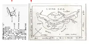
If you mean the Mar Del, I do not dispute Wilkins drew them. One even has his name as a copyright. Wilkins admitted these maps were largely imaginary because he was prevented from closely copying the maps in Hubert Palmer's possession (the so-called Kidd-Palmer maps). In his own words, "[Palmer's] refusal to let me copy this chart [Coral Island Map?] and I did not blame him. Why should he furnish an illustration to the publisher for my book". However, a few details he was allowed to copy from memory having seen the Kidd-Palmer maps earlier, writing: "I incorporated as much detail from the collector's chart as he would allow"; for example, "reef(s)", coral [beach], "wrecks", "hills" and "woods" appear on the Coral Island Map and/or Skeleton Map and the Mar Del maps. Wilkins admitted to changing the shape of the island in the Mar Del maps and making up the map legend for the location of the buried treasure or cache; furthermore, he was clear he made up the clues such as "7 by 8 by 4" on the Mar Del maps:

I added a legend for the location of the cache which was totally different from the original. It was meant only as an illustration for my book.

- "Mystery of the Pirate's Chart", FATE Vol. 3, No. 8 p. 29

For this reason, I have never taken seriously the idea there are real clues in the Mar Del maps unless you only take into consideration the vague "reef(s)", coral [beach], "wrecks", "hills" and "woods".

As for the Kidd-Palmer maps, there is much evidence against Wilkins being involved in the hoax (the hoaxer was instead Cutler). For starters, are you aware Wilkins did not see one or more of the maps until 1932? By that time, Palmer already had acquired most of the maps. The timeline makes no sense to involve Wilkins. We also know Wilkins wrote to his brother about these maps and repeatedly stated he believed they were authentic. Would he really go as far as duping his family members?
 
First off, it’s not known that the maps are fake or a hoax and so nobody should be stating this to be a fact. It’s opinion, surmise, and should be expressed as such. The map contents could be fake, but then again they may not be. We don’t know either way so nobody should be declaring that they do.

I, too, fail to understand why there should be such a fuss about whether the date was 1957 or 1956 when there are so many more significant questions still outstanding.

If there's no absolute proof that the purchase occurred in 1957 then I suggest that the date provided by the putative purchaser should be the one preferred. However, I note that it has been suggested that Taylor deceived Furneaux about his being the purchaser as there are newspaper reports that the maps were purchased in the mid-1960s.

The 1964 date may well have arisen because approaches were certainly made to Mrs. Dick about buying the maps in that year not knowing that they had been sold. This explanation was clearly always a potential answer to the conflicting sources, but has for some reason been totally discounted.

I’m fully aware that George read through Furneaux’s papers way back, and he may well have made a mistake in taking down the date, but it's hardly important. However, it would perhaps have been more appropriate to take note of what the person holding Taylor's letter is saying, unless perhaps it’s believed that this individual is also attempting to deceive people.

As this seems to be the prevailing opinion, I include below the relevant extract from the letter in the hope that we might all learn something from this episode and move on to more important matters.

View attachment 2219219
Well Maurice was well and truly duped!.....'and all copies thereof'. How is it then that I have the chart negatives??
 
What maps do you mean? The Kidd-Palmer maps or the Mar Del maps?
Wilkins did not state that he had faked any of the legends (instructions) on his three maps, he only observed that they were not as on the original Palmer maps. He also did not reveal where he got those instructions from.
 
Well Maurice was well and truly duped!.....'and all copies thereof'. How is it then that I have the chart negatives??
I assume that Mrs. Dick was unaware of the fact that the negatives had either been taken without her permission or had been misappropriated by people who should have known better than to keep them. I would further observe that should there have been a contract of sale incorporating the words 'and all copies thereof' then your negatives actually belong to Taylor and should be returned to his heirs. I don't think Taylor was 'well and truly duped' by Mrs. Dick, but that she was more than likely willfully deceived by people close to her.
 
As this seems to be the prevailing opinion, I include below the relevant extract from the letter in the hope that we might all learn something from this episode and move on to more important matters.

View attachment 2219219
Thanks for posting this. Do you know what year Maurice Taylor was born or any other details (C. R. = ?.) Based on newspaper reports in 1951 that said he was 27, this would put his date of birth in 1924 but it is possible they were slightly inaccurate. While I do not trust what Taylor wrote in the letter, I can try and get in touch with his family to see if they know anything. He could still be alive but would now be ~100 (unlikely but not impossible). The more newspaper articles I read that mention and quote Taylor, the less credible he appears. He bizarrely thought Chinese pirates were going to chase him and that he would "have unearthed the treasure and be back again in six months".

1754005699588.webp


The Grape Belt and Chautauqua Farmer (2 November 1951)
 
Last edited:
Thanks for posting this. Do you know what year Maurice Taylor was born or any other details (C. R. = ?.) Based on newspaper reports in 1951 that said he was 27, this would put his date of birth in 1924 but it is possible they were slightly inaccurate. While I do not trust what Taylor wrote in the letter, I can try and get in touch with his family to see if they know anything. He could still be alive but would now be ~100 (unlikely but not impossible). The more newspaper articles I read that mention and quote Taylor, the less credible he appears. He bizarrely thought Chinese pirates were going to chase him and that he would "have unearthed the treasure and be back again in six months".

View attachment 2219288

The Grape Belt and Chautauqua Farmer (2 November 1951)
You may recall that I opened my Book 1 with this episode and its sad end.

I believe that Crow may have done some research into Taylor's background, and might perhaps be approached for his contribution to the discussion.
 
Last edited:
Wilkins did not state that he had faked any of the legends (instructions) on his three maps, he only observed that they were not as on the original Palmer maps. He also did not reveal where he got those instructions from.
Hi gjb,
Do you have a theory on where Wilkins got those instructions from?
 
It seems frequently to be assumed that because the medium is fake then so also is the message. I get the impression that many would agree that the maps are probably not original, but they don't reject the possibility that they may be copies of copies of copies. Hence, focus on what they say not the paper they're written on, the ink used, when it was written and who wrote it.

I've found no proof that Wilkins created the Palmer maps, otherwise I completely agree. Wilkins doesn't deny that the island outlines of his own maps are his own creations, and he openly claims copyright. However, the same applies: the instructions written on his maps could nevertheless be original, and Wilkins was fully aware that they are just that.
Wilkins liked to play games, especially with the gullible and those who couldn't put 2 plus 2 together. He did many things like this for example, writing to Gilbert Hedden and including some obvious tell that he had drawn the maps knowing that for many something as basic as checking the handwriting was above their pay grade.
 

Attachments

  • wilkins smoking gun cut.webp
    wilkins smoking gun cut.webp
    1.6 MB · Views: 74
Or, let's see, such a choice of Wilkins 'in-jokes' to choose from!

That it said 'turtles' because you were looking at a turtle.


circle.webp


And the map itself was just a copy of a 25 cent map of Juan Fernandez Island.

glno176asmall.webp


You can just go on and on showing the joke tells but how basic and obvious they were can get a bit embarrassing for those who staked their research 'findings' on them being real........
 
Last edited:
Hi gjb,
Do you have a theory on where Wilkins got those instructions from?
Hi Randawg72
Here's the problem! I've reported this somewhere else on the forum, but it's just a personal experience not proven fact, and nobody seems to want to follow up the implications. When I was hunting for primary and secondary sources concerning the maps I was contacted by an old gentleman who claimed to hold the source file from which they were copied. This proved to be a private collection of documents apparently assembled in the latter part of the 18th century. I was allowed to see some of the file including the claimed predecessors of the maps. I recognised the island depicted, but nobody wants to believe this or wishes to follow it up. From what you've written, I very much doubt that you would either!
 
Or, let's see, such a choice of Wilkins 'in-jokes' to choose from!

That it said 'turtles' because you were looking at a turtle.


View attachment 2219457

And the map itself was just a copy of a 25 cent map of Juan Fernandez Island.

View attachment 2219458


You can just go on and on showing the joke tells but how basic and obvious they were can get a bit embarrassing for those who staked their research 'findings' on them being real........
I’ve found no evidence that Wilkins was playing games, on the contrary he was deadly serious. This is very apparent from the evidence of his private papers. He wanted a shot at the treasure and wasn’t prepared to reveal all his cards. He also felt the need to put people off the scent, hence his outrageous response to Hedden who had gotten far too close to the truth for comfort.

Wilkins wasn’t the one who selected Juan Fernandez as the island, this was the belief of the people who owned the originals of the maps from which Wilkins extracted his information. There's potential evidence that 'Turtle' of 'Turtles' may have been the name given to the island: Tortuga, Tortue or Turtle Island.
 
That it said 'turtles' because you were looking at a turtle.

View attachment 2219457

And the map itself was just a copy of a 25 cent map of Juan Fernandez Island.

View attachment 2219458


You can just go on and on showing the joke tells but how basic and obvious they were can get a bit embarrassing for those who staked their research 'findings' on them being real........
I have seen quite a few turtles and this one looks quite deformed and sick. If you want to see one in the drawing you probably will.
He did many things like this for example, writing to Gilbert Hedden
Can you post the whole text? When did he write this?
 
Last edited:
Or, let's see, such a choice of Wilkins 'in-jokes' to choose from!

That it said 'turtles' because you were looking at a turtle.


View attachment 2219457

And the map itself was just a copy of a 25 cent map of Juan Fernandez Island.

View attachment 2219458


You can just go on and on showing the joke tells but how basic and obvious they were can get a bit embarrassing for those who staked their research 'findings' on them being real........
I think you got the above from George Edmunds website. I am not convinced. The turtle thing is pareidolia. Nothing more. While my view is the maps are indeed a hoax, Edmunds idea about turning the island upside down and the turtle is very speculative.

Concerning Juan Fernandez Island, about a dozen different islands on old charts appear very similar in shape to the island on the Kidd-Palmer maps. This is why I doubt whether the hoaxer was inspired by or based their drawing on Juan Fernandez Island. Furthermore, I think I have found a partial insular location fitting the shape which the maps point to (but I have not yet published my findings).
 
I think you got the above from George Edmunds website. I am not convinced. The turtle thing is pareidolia. Nothing more. While my view is the maps are indeed a hoax, Edmunds idea about turning the island upside down and the turtle is very speculative.

Concerning Juan Fernandez Island, about a dozen different islands on old charts appear very similar in shape to the island on the Kidd-Palmer maps. This is why I doubt whether the hoaxer was inspired by or based their drawing on Juan Fernandez Island. Furthermore, I think I have found a partial insular location fitting the shape which the maps point to (but I have not yet published my findings).
I'm sorry, but I feel that you’re doing exactly what you’re criticising others for doing, and you’re ignoring evidence from Wilkins himself, even from his books, apparently because it doesn’t suit your thinking!

The map on the inside page of Wilkins’ book is based on a 17th century chart of Juan Fernandez, and this can be demonstrated by the overall outline and the presence of ‘Goat Hills’ in exactly the same location and also, very unusually, a scharfes ‘S’ in the word ‘False’ the original being accompanied by an anchor and the 'copy' with the word ‘Anchorage’ signifying the same thing. We also have ‘Hunters Gulley’ and ‘Death Valley’ in much the same location, as below.

JF Old Wilkins.gif


At left above is an image of the original 17th century chart. It may be deduced that Wilkins, having observed that Palmer’s maps reference Rocks, a Lagoon and Sand and Coral, then adjusted his copy map of Juan Fernandez to suit. Juan Fernandez has no coral reefs and no desert, but the fact that Wilkins added these does not mean that this is not the island upon which he based his outline.

The same argument can be applied to the map on the book’s endpapers. Wilkins’ second map has the same outline as the first and the same features in the same locations: the Lagoon and Coral banks. Some of the text is also the same: Cape Blanco, Mar Del, Galleon Wrecks and Lat.dmd.

Thus, being so similar to the first, one might safely observe that the second map is intended to depict the same island - that is, Juan Fernandez. The fact that the compass roses are different doesn’t necessarily mean that they are completely different islands.

Wilkins was fully aware that the maps’ owners believed this to be the island the instructions pertained to and thereafter picked on a 17th century chart of the island, based on the 1669 date referenced by the Palmer maps, not knowing that the group had selected the island’s outline from an 18th century chart as below:

JF Old Palmer.gif


This might be recognised as Palmer’s ‘Coral Island Map’ but without the Lagoon and Coral Bank, though those not wishing to concede the possibility will inevitably declare that it is definitely not so. It should be noted that neither chart of Juan Fernandez is particularly accurate, though the one above is the closer of the two.

This aside, the outline of the Key Chart or Skeleton Map doesn’t fit this profile particularly well, though the map from which it was drawn doesn’t either. The outline of the map from which the instructions were taken actually appears in Wilkins book Captain Kidd and His Skeleton Island for which see (Wilkins,1934, p345) or (Wilkins,1937, p383) where he presents it as ‘John S’s Rough Map’.

OI Gloucs John Ss.gif


This matches the outline of Oak Island as Gloucester Isle from an 18th century chart by J.F.W Des Barres (as do the maps containing Wilkins' instructions that I saw). Note the distinctive inlet at northwest, the two apparent ‘rivers’ in exactly the same locations and the promontory in the form of a bulb at east.

So, what was Wilkins doing including a map of Oak Island in a book about Kidd and the Kidd maps and then asking his readers to identify it for him? He desperately wanted to know where the island was, because he knew that this was the island to which the instructions actually apply!

Despite what’s being claimed here, the instructions may therefore equally have first appeared on maps of Oak Island, though the outline looked very little like what it does today. As the island was not initially identified, it was thereafter assumed that it was Juan Fernandez, though for a number of questionable reasons.

So, the instructions were written onto copies of an 18th century chart of that island thus giving rise to the Palmer maps. Wilkins simply chose to put the instructions that he obtained from the very same source onto his version of a chart of the same island, but as depicted in the 17th century. In this event, the instructions on all the maps, including the Flood Map, would not apply to the island depicted.
 
Last edited:
I'm sorry, but I feel that you’re doing exactly what you’re criticising others for doing, and you’re ignoring evidence from Wilkins himself, even from his books, apparently because it doesn’t suit your thinking!

The map on the inside page of Wilkins’ book is based on a 17th century chart of Juan Fernandez, and this can be demonstrated by the overall outline and the presence of ‘Goat Hills’ in exactly the same location and also, very unusually, a scharfes ‘S’ in the word ‘False’ the original being accompanied by an anchor and the 'copy' with the word ‘Anchorage’ signifying the same thing. We also have ‘Hunters Gulley’ and ‘Death Valley’ in much the same location, as below.

View attachment 2219519

At left above is an image of the original 17th century chart. It may be deduced that Wilkins, having observed that Palmer’s maps reference Rocks, a Lagoon and Sand and Coral, then adjusted his copy map of Juan Fernandez to suit. Juan Fernandez has no coral reefs and no desert, but the fact that Wilkins added these does not mean that this is not the island upon which he based his outline.

The same argument can be applied to the map on the book’s endpapers. Wilkins’ second map has the same outline as the first and the same features in the same locations: the Lagoon and Coral banks. Some of the text is also the same: Cape Blanco, Mar Del, Galleon Wrecks and Lat.dmd.

Thus, being so similar to the first, one might safely observe that the second map is intended to depict the same island - that is, Juan Fernandez. The fact that the compass roses are different doesn’t necessarily mean that they are completely different islands.

Wilkins was fully aware that the maps’ owners believed this to be the island the instructions pertained to and thereafter picked on a 17th century chart of the island, based on the 1669 date referenced by the Palmer maps, not knowing that the group had selected the island’s outline from an 18th century chart as below:

View attachment 2219520

This might be recognised as Palmer’s ‘Coral Island Map’ but without the Lagoon and Coral Bank, though those not wishing to concede the possibility will inevitably declare that it is definitely not so. It should be noted that neither chart of Juan Fernandez is particularly accurate, though the one above is the closer of the two.

This aside, the outline of the Key Chart or Skeleton Map doesn’t fit this profile particularly well, though the map from which it was drawn doesn’t either. The outline of the map from which the instructions were taken actually appears in Wilkins book Captain Kidd and His Skeleton Island for which see (Wilkins,1934, p345) or (Wilkins,1937, p383) where he presents it as ‘John S’s Rough Map’.

View attachment 2219522

This matches the outline of Oak Island as Gloucester Isle from an 18th century chart by J.F.W Des Barres (as do the maps containing Wilkins' instructions that I saw). Note the distinctive inlet at northwest, the two apparent ‘rivers’ in exactly the same locations and the promontory in the form of a bulb at east.

So, what was Wilkins doing including a map of Oak Island in a book about Kidd and the Kidd maps and then asking his readers to identify it for him? He desperately wanted to know where the island was, because he knew that this was the island to which the instructions actually apply!

Despite what’s being claimed here, the instructions may therefore equally have first appeared on maps of Oak Island, though the outline looked very little like what it does today. As the island was not initially identified, it was thereafter assumed that it was Juan Fernandez, though for a number of questionable reasons.

So, the instructions were written onto copies of an 18th century chart of that island thus giving rise to the Palmer maps. Wilkins simply chose to put the instructions that he obtained from the very same source onto his version of a chart of the same island, but as depicted in the 17th century. In this event, the instructions on all the maps, including the Flood Map, would not apply to the island depicted.
To clarify, my previous post meant the Kidd-Palmer maps (not the Mar Del maps), however, my point applies to the latter as well:

Concerning Juan Fernandez Island, about a dozen different islands on old charts appear very similar in shape...

You can take the shapes of the islands on both the Kidd-Palmer maps and Mar Del maps and find them closely resemble a dozen (if not more) real islands. As an example, Richard Knight was convinced the island on the Kidd-Palmer maps matches Hon Tre Lon; Rupert Furneaux, the Providenciales, and so on. The shape also vaguely resembles early maps of Nantucket. Any similarities are coincidental.

Compare the images you posted:

1754156267670.webp


To Hon Tre Lon:
1754156367389.webp


Why should the chart of Juan Fernandez be preferred over Hon Tre Lon? For the record, I do not think the Kidd-Palmer maps have anything to do with Hon Tre Lon, or Juan Fernandez. I am merely using Hon Tre Lon as an example to highlight you can find many different similar shaped islands and the shape similarity is purely a coincidence.

I am not remotely convinced Wilkins Mar Del maps are related to Juan Fernandez island; you state:

The map on the inside page of Wilkins’ book is based on a 17th century chart of Juan Fernandez, and this can be demonstrated by the overall outline and the presence of ‘Goat Hills’ in exactly the same location and also, very unusually, a scharfes ‘S’ in the word ‘False’ the original being accompanied by an anchor and the 'copy' with the word ‘Anchorage’ signifying the same thing. We also have ‘Hunters Gulley’ and ‘Death Valley’ in much the same location, as below.

Again, I would say this is coincidence; in fact, the shape is not a very close match (Mar Del island is wider at middle-bottom):

1754158748759.webp


There are admittedly "hills" in the same location (on left of both maps) but that's about it; trees are not in a similar position. No matching desert, palms, wrecks, etc; "rock(s)" appear on the right on the Mar Del map, but on the opposite side on the other map. There are far more differences than similarities between these maps. Furthermore, Wilkins (1950) seems to contradict your claims.

According to Wilkins (1950):

1754159487721.webp


I will quote the relevant text:

"However, my London published was insistent on having a chart. Now I have some knowledge of pirate charts of the 17th and 18th centuries and am familiar with their peculiar style and cartographic detail. I sat down in my den and out of my imagination I drew a chart such as a 17th buccaneer might have produced. I modified the outline of the island as I remembered it from the real Kidd treasure chart belonging to the collector. I made my island about 3 miles long by 2 miles wide running NE to SW., and marked it South China Sea. I incorporated as much detail from the collector's chart as he would allow and I put in such tropical features as coral reefs, coco-palms, a landing place, hills, a 'death valley', and at the bottom added the initials of Kidd and the date 1669. I thought it was obvious that my island must be in the tropics. I even inverted he compass points giving a true north, geographic, not magnet, which was not in the collector's chart. I added a legend of the cache which was totally different from the original. It was meant only as an illustration for my book."

This contradicts your earlier comment:

Wilkins did not state that he had faked any of the legends (instructions) on his three maps, he only observed that they were not as on the original Palmer maps. He also did not reveal where he got those instructions from.
If you read Wilkins though, what he actually says is he made up the (legend) instructions "only as an illustration for my book".

Wilkins made up the instructions on the Mar Del maps. His own article even summarised the map was from his imagination: "The author drew up a treasure map out of his imagination." The Mar Del Maps have nothing whatsoever to do with instructions to a buried treasure on Oak Island, or anywhere for that matter since Wilkins was clear he made the instructions up out of whole cloth.
 
I’ve found no evidence that Wilkins was playing games, on the contrary he was deadly serious. This is very apparent from the evidence of his private papers. He wanted a shot at the treasure and wasn’t prepared to reveal all his cards. He also felt the need to put people off the scent, hence his outrageous response to Hedden who had gotten far too close to the truth for comfort.
I read his response to Hedden (and Palmer's) as very different. Both were fed up with the idea of trying to link Oak Island to the Kidd-Palmer maps and Wilkins made clear the maps including his own (the Mar Del) and Captain Kidd have nothing to do with Oak Island in a letter he published in The Listener: "The yarn of Oak Island and Captain Kidd is one that newspaper men, Canadian and United States news hounds... have repeated ad nauseum..." I am baffled how you somehow managed to reach the opposite conclusion. :confused:

1754181698299.webp
 
I think you got the above from George Edmunds website. I am not convinced. The turtle thing is pareidolia. Nothing more. While my view is the maps are indeed a hoax, Edmunds idea about turning the island upside down and the turtle is very speculative.

Concerning Juan Fernandez Island, about a dozen different islands on old charts appear very similar in shape to the island on the Kidd-Palmer maps. This is why I doubt whether the hoaxer was inspired by or based their drawing on Juan Fernandez Island. Furthermore, I think I have found a partial insular location fitting the shape which the maps point to (but I have not yet published my findings).
To add to this comment, I will note how other individuals have rotated the Kidd-Palmer maps to match them to different island shapes. Seems arbitrary, and doing this can match to dozens more islands across the world, which is correct? Well, none are. One such example is the French writer Albert Fagioli; you can watch him in a video here. He identified the island in the Coral Island Map as Koh Matlang (located close to the coast of Chaweng Beach on Koh Samui, Thailand) but confusingly the island in the Skeleton Map as a separate island also near Thailand; a newspaper reporting about this can be read here. Of course, like the others his idea is completely wrong.

1754184101392.webp


As with Oak Island, Hon Tre Lon, Juan Fernandez, etc., doing this is counterproductive and quite frankly pointless. Thankfully, it is not something I have wasted my time with (the location I think the hoaxer might have based the map on is not an island). The reality is, the Kidd-Palmer maps have nothing to do with any of these islands and you can rotate the island on the Kidd-Palmer maps to match many different islands across the globe. It is an arbitrary exercise.
 
Last edited:

Users who are viewing this thread

Back
Top Bottom