- #1
Thread Owner
In an attempt to simplify the information that I shared in my thread LUE MAP THEORY, MAYBE SOME CONTEXT, I decided to start this thread. I'll keep it brief.

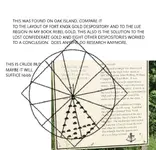
The orientation of the map is South at the top, North at the bottom, West on the right and East on the left.
The three large triangles in the lower right quadrant, represent the United States. The dot at the top of the center triangle is at 45deg 48' 47" N and 95deg 40' 18" W, the site of the Kensington Runestone, in Minnesota. Scott Wolter has written that in 1926 ten men initiated an effort to raise $300,000 to build a 204 foot obelisk that would house the Kensington Runestone. Eight of these ten men were Masons.
The dot in the center of the circle is at 42deg 35' 59" N and 109deg 38' 22" W.
The lower right corner of the center triangle is at 29deg 58' 45" N and 81deg 18' 44" W. This site is just north of St. Augustine, Florida which is one of the earliest Spanish settlements in what is now the United States. The latitude, at this point, is the same latitude as the Great Pyramid of Giza, Egypt.
The horizontal line that bisects two of the triangles varies between 37deg 41' N, on the left, and 37deg 23' N. on the right. On this latitude there are several treasure and treasure legend related sites. They are. the Beale Treasure, the Swift Treasure, Fort Knox Bullion Depository, Blanca Peak, Colorado and Treasure Mountain, Colorado. Further west, the latitude passes 13 miles north of the Four Corners Monument and into the Monument Valley of Utah.
I think this latitude was chosen because it is halfway between the latitude of the Kensington Runestone 45deg 48' N and the latitude of the Great Pyramid, 29deg 58' N, whose latitude is found just north of St. Augustine, Florida. The halfway point, between those two latitudes, is at 37deg 53' N, which is the latitude of the United States Bullion Depository at Fort Knox. This is interesting because Fort Knox is mentioned in Von Mueller's caption under the picture of the LUE map in Treasure Hunter's Manual #7. Something else of interest is found in Von Mueller's book Treasure of the Valley of Secrets. In his book, he mentions Blanca Peak, Treasure Mountain and Monument Valley, Utah, all places along the bisecting latitude.
Another place on this bisecting latitude is found on the west side of Blanca Peak. Von Mueller has written that the word LUE came from the first letters of three words written on the map, LLORO URRACA ENTERRARI, I cry, magpie, bury. I believe this phrase refers to the Pioneer Urraca Cemetery at the foot of Blanca Peak.
In the upper left quadrant of the LUE map are five steps that could be used to show latitude, each step would equal ten degrees. Five is also a number that is associated with the five petals on the red wild rose and the five wounds on Christ at the Cross. The red wild rose would represent the blood of Christ. Blanca Peak is located in a mountain range named Sangre de Christo, the blood of Christ. The steps on the LUE map could indicate the Sangre de Christo Mountains.
In the middle of the LUE map, where the quadrants join, there are four corners. These corners could indicate the Four Corners region of Colorado, New Mexico, Arizona and Utah.
In the upper left quadrant the Sun and it's rays should be considered a protractor. The rays show degree headings. The headings are 103.5, 119, 134, 150, 165, 180, 196, 210, 227, 242 and 257. Start these headings at the Kensington Runestone and the point in the circle location. Run the lines to the borders of the United States, using Google Earth or a table map that shows latitude and longitude as slightly curving lines. Two more starting points will be on the north side of Fort Knox and at a point 13 miles above the Four Corners Memorial. The intersections of these lines will create multiple locations on your map of the United States. Some of the intersections will be near areas associated with treasure legends. Some locations are at Socorro, New Mexico, The Spider Rock location in Texas, Wildcat Bluff, Arkansas and the Waterhouse Treasure legend of NE Georgia.
Many thanks to Randy Bradford for the LUE map information that he has shared over the years.
The orientation of the map is South at the top, North at the bottom, West on the right and East on the left.
The three large triangles in the lower right quadrant, represent the United States. The dot at the top of the center triangle is at 45deg 48' 47" N and 95deg 40' 18" W, the site of the Kensington Runestone, in Minnesota. Scott Wolter has written that in 1926 ten men initiated an effort to raise $300,000 to build a 204 foot obelisk that would house the Kensington Runestone. Eight of these ten men were Masons.
The dot in the center of the circle is at 42deg 35' 59" N and 109deg 38' 22" W.
The lower right corner of the center triangle is at 29deg 58' 45" N and 81deg 18' 44" W. This site is just north of St. Augustine, Florida which is one of the earliest Spanish settlements in what is now the United States. The latitude, at this point, is the same latitude as the Great Pyramid of Giza, Egypt.
The horizontal line that bisects two of the triangles varies between 37deg 41' N, on the left, and 37deg 23' N. on the right. On this latitude there are several treasure and treasure legend related sites. They are. the Beale Treasure, the Swift Treasure, Fort Knox Bullion Depository, Blanca Peak, Colorado and Treasure Mountain, Colorado. Further west, the latitude passes 13 miles north of the Four Corners Monument and into the Monument Valley of Utah.
I think this latitude was chosen because it is halfway between the latitude of the Kensington Runestone 45deg 48' N and the latitude of the Great Pyramid, 29deg 58' N, whose latitude is found just north of St. Augustine, Florida. The halfway point, between those two latitudes, is at 37deg 53' N, which is the latitude of the United States Bullion Depository at Fort Knox. This is interesting because Fort Knox is mentioned in Von Mueller's caption under the picture of the LUE map in Treasure Hunter's Manual #7. Something else of interest is found in Von Mueller's book Treasure of the Valley of Secrets. In his book, he mentions Blanca Peak, Treasure Mountain and Monument Valley, Utah, all places along the bisecting latitude.
Another place on this bisecting latitude is found on the west side of Blanca Peak. Von Mueller has written that the word LUE came from the first letters of three words written on the map, LLORO URRACA ENTERRARI, I cry, magpie, bury. I believe this phrase refers to the Pioneer Urraca Cemetery at the foot of Blanca Peak.
In the upper left quadrant of the LUE map are five steps that could be used to show latitude, each step would equal ten degrees. Five is also a number that is associated with the five petals on the red wild rose and the five wounds on Christ at the Cross. The red wild rose would represent the blood of Christ. Blanca Peak is located in a mountain range named Sangre de Christo, the blood of Christ. The steps on the LUE map could indicate the Sangre de Christo Mountains.
In the middle of the LUE map, where the quadrants join, there are four corners. These corners could indicate the Four Corners region of Colorado, New Mexico, Arizona and Utah.
In the upper left quadrant the Sun and it's rays should be considered a protractor. The rays show degree headings. The headings are 103.5, 119, 134, 150, 165, 180, 196, 210, 227, 242 and 257. Start these headings at the Kensington Runestone and the point in the circle location. Run the lines to the borders of the United States, using Google Earth or a table map that shows latitude and longitude as slightly curving lines. Two more starting points will be on the north side of Fort Knox and at a point 13 miles above the Four Corners Memorial. The intersections of these lines will create multiple locations on your map of the United States. Some of the intersections will be near areas associated with treasure legends. Some locations are at Socorro, New Mexico, The Spider Rock location in Texas, Wildcat Bluff, Arkansas and the Waterhouse Treasure legend of NE Georgia.
Many thanks to Randy Bradford for the LUE map information that he has shared over the years.