What's new

LUE MAP THEORY, MAYBE SOME CONTEXT

Reading on page 1 someone mentioned Colorado I've always wondered if there was a reason Karl Von M lived in Segundo? Did he pick it because it was close to a treasure he was investigating?
 
Reading on page 1 someone mentioned Colorado I've always wondered if there was a reason Karl Von M lived in Segundo? Did he pick it because it was close to a treasure he was investigating?
Von Mueller wrote an article about that and Randy Bradford included it in one of his books. Von Mueller said he liked the area and the people and the treasure legends associated with the location. He was investigating a treasure cave that was uncovered in the mountains west of Segundo. He wrote a book named The Treasure of the Valley of Secrets that describes his research.
 
  • Like
Reactions: neo
Reading on page 1 someone mentioned Colorado I've always wondered if there was a reason Karl Von M lived in Segundo? Did he pick it because it was close to a treasure he was investigating?
I don't think it was because of the LUE, but I do think he moved there to be closer to the cave of gold he talks about in Treasure of the Valley of Secrets.
 
View attachment 2139095View attachment 2138981
These two pictures shoe the LUE Map and a map I created plotting great circle lines over a map of the United States. As you can see, the pyramid shown by the yellow lines is similar to the pyramid in the upper left quadrant of the LUE Map. I wasn't trying to solve the LUE Map but I was studying the Kensington Runestone and trying to figure out if there was any organized placement of the stone. As I researched the site, I noticed some features that were on the LUE Map so I thought I would share the information and you can decide for yourself if there is anything useful in my mapping that might relate to the LUE legend.
Too much baloney, no steak.

None of this map of the Continental USA equals to anything.

The farthest point on the map is less than thirty miles to the next point as the crow flies. All the other points are within the thirty miles to each other symbol on the map.

Think about Glen Carson’s book Palo Dura that and the center of the center Pillar on L U E map are the same kind of ground feature.

The Spanish were no dummies when they devised the map. It’s not Nazi, KGC or Knights Templar.

Contemplate this when you are looking at the map. Each equals a certain ground feature.

Bests in Treasure

LUE-Hawn
 
Too much baloney, no steak.

None of this map of the Continental USA equals to anything.

The farthest point on the map is less than thirty miles to the next point as the crow flies. All the other points are within the thirty miles to each other symbol on the map.

Think about Glen Carson’s book Palo Dura that and the center of the center Pillar on L U E map are the same kind of ground feature.

The Spanish were no dummies when they devised the map. It’s not Nazi, KGC or Knights Templar.

Contemplate this when you are looking at the map. Each equals a certain ground feature.

Bests in Treasure

LUE-Hawn

Thanks for the comments.

I've read many of your posts about the LUE, over the years. You have given some good hints but never explained the symbolism on the map. I believe you have said it's on private ground and out of reach. You have posted that it is all common sense, but still no explanation of the symbols.

Please tell us how you interpret the map, so that your theory can be on record, with all the others.
 
Thanks for the comments.

I've read many of your posts about the LUE, over the years. You have given some good hints but never explained the symbolism on the map. I believe you have said it's on private ground and out of reach. You have posted that it is all common sense, but still no explanation of the symbols.

Please tell us how you interpret the map, so that your theory can be on record, with all the others.
It’s an active site here in Colorado, no other place in the USA. Don’t be ridiculous I’m not going to lead you to something that has already been found. The map in TOTVOS is an earlier representation of the L U E Map. Nearly everything on the stone carved map is an indication of what the L U E Map is and where it is located in this state.

I will give you a tickler. See the top of the mountain with the black triangular shadow. Its only visible from late October to early November so long as its not overcast, raining or snowing.

Bests in Treasure

LUE-Hawn
 
If you weren’t paying attention. I had two photographs up for about a minute then deleted them.

Bests in Treasure

LUE-Hawn
 
Too much baloney, no steak.

None of this map of the Continental USA equals to anything.

The farthest point on the map is less than thirty miles to the next point as the crow flies. All the other points are within the thirty miles to each other symbol on the map.

Think about Glen Carson’s book Palo Dura that and the center of the center Pillar on L U E map are the same kind of ground feature.

The Spanish were no dummies when they devised the map. It’s not Nazi, KGC or Knights Templar.

Contemplate this when you are looking at the map. Each equals a certain ground feature.

Bests in Treasure

LUE-Hawn
I respect your opinion, but the LUE map is full of Masonic symbols, not Spanish ones. That said, maybe it was done by Spanish, or Mexican Freemasons.......who knows.
 
It’s an active site here in Colorado, no other place in the USA. Don’t be ridiculous I’m not going to lead you to something that has already been found. The map in TOTVOS is an earlier representation of the L U E Map. Nearly everything on the stone carved map is an indication of what the L U E Map is and where it is located in this state.

I will give you a tickler. See the top of the mountain with the black triangular shadow. Its only visible from late October to early November so long as its not overcast, raining or snowing.

Bests in Treasure

LUE-Hawn
I think our biggest difference of opinion is that you think the map leads to one location and I think that the map leads to dozens of treasure related sites.
 
I think our biggest difference of opinion is that you think the map leads to one location and I think that the map leads to dozens of treasure related sites.
I said in an earlier post the area in question is under 30 miles as the crow flies. Every single line on the map represents a certain ground feature not one single site. You misunderstood it as a single site. Which it is not. I posted a hint for one minute of one of the ground features that can only be seen between late October and early November. I will post it again for ten seconds a little after 10:00 tomorrow 07/17/2025 Mountain Time of the black triangular shadow on the pyramid symbol on the left side of the L U E map if anyone is interested.

Bests in Treasure

LUE-Hawn
 
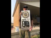
Randy Bradford will be a the Moon Lake Gathering August 14,15 and 16 2025 at the Duchesne Events Center in Duchesne, Utah. All you treasure hunters out there won’t want to miss this one. It’s FREE to attend all you have to do is rent a hotel or camp out.

Terry Carter will be there too, he is featured in the attached photograph at the August 2021 Moon Lake Gathering when it was in Altamont, Utah.
 

Attachments

  • IMG_3704.webp
    IMG_3704.webp
    241.2 KB · Views: 77
Last edited:
Reading on page 1 someone mentioned Colorado I've always wondered if there was a reason Karl Von M lived in Segundo? Did he pick it because it was close to a treasure he was investigating?
Correct on Karl Von Mueller.
 
Correct on Karl Von Mueller.
Look to Masonic and or KGC graveyards. A grave marked in a special way. Best place in the world to hide a box of treasure. Those who are Masons remember your 3rd degree. If you think about it Pyramid's are graves. The blocks on the lower left remind me of graves lined up.
Sgtfda PM
 
Last edited:
So...... I know I skipped out on this Lue discussion, BUT.... you may be interested in this if you havent seen it already.
Ill be there at the 2025 Moon Lake gathering and I hope to meet some of you guys/gals in person. Ill probably make an adventure of it and take my motorcycle from Phoenix and sleep next to it under the stars.
It'll be a blast!! :)


Side note, going back to pages ago when I was going on and on about "consciousness" and boring everybody with Masonic symbolism and its deeper meanings......
Bob Brewer just said something interesting in that video above: that the immediate area around me (Superstition Mtn area) was named by the....lets just say "organization" to reflect the book "Through the Looking Glass," (Queen Creek. Silver King. Etc..) or as we know it...Alice in Wonderland, which....as you know is an exploration of consciousness.

That is all ;)

Look to Masonic and or KGC graveyards. A grave marked in a special way. Best place in the world to hide a box of treasure. Those who are Masons remember your 3rd degree. If you think about it Pyramid's are graves. The blocks on the lower left remind me of graves lined up.
Sgtfda PM
Sgtfda, Please don't say things you are not sure of, Yes there are clues in cemeteries but the organization did not put treasure in graves, Many graves have be desecrated by rogue treasure hunters. In all my years working with others on treasure never, that I know of, was treasure found in graves some of them may have dug into. Even if gold was buried with some person, reputable treasure hunters would not violate a grave, which a honest people consider sacred. One cemetery near my old home was forgotten by all but those who knew those buried there. A logging crew cut timber near the graves and soon after they all were dug up. I know the names and families they were all from and no gravestone, (all stones) had any treasure related markings. I am investigating this criminal action and will give any evidence to our Prosecuting Attorney. I have found clues on the perimeter of cemeteries that led to recoveries and headstones giving directions and distances but again, I sincerely believe no treasure was in any of the many graves with coded information. Please, never dig into a grave, even if it lies in a forgotten graveyard.
HBBB
 
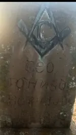
Graveyards' values are typically above ground, especially if the information carved on the stone is one tied into the lore. The names, dates and birth/death locations can alert to other meanings. There's a "Crittenden" grave in the old Georgetown cemetery near Santa Rita NM (James connection), another one with a "Lone Pine" place of birth notation (frequently KGC usage). And another quite modest one that HBBB's now deceased partner told me could mean "Free Mason" with a directional pointer. All pretty subtle stuff.
F.M..webp
 
The few clues we have found In cemetaries here in north Louisiana, are directional in nature. Look closely @ the letter N in Johnson. The top has the directional sign telling you to travel to the left when facing it. This is repeated across more than one cemetary and over many miles. Now you could argue that the bottom also has a pointer, but so far it seems the top is the direction to go. So, very subtle like you said. They also used trees of course as Mr. Brewer has already said. There is an old confederate cemetary down the road from me that has what I call an "eye of the needle". This needle shape is formed by the fusion of two large tree trunks. It is the beginning of a secret trail through a large swamp and this trail also happens to be the shortest way across to dry land. I can't find a pic of the tree, but if anyone is interested I can go take one tomorrow. This trail is also confirmed by signs on a captured confederate map from 1865 of the area.
 

Attachments

  • IMG_4908.webp
    IMG_4908.webp
    33.9 KB · Views: 67
The few clues we have found In cemetaries here in north Louisiana, are directional in nature. Look closely @ the letter N in Johnson. The top has the directional sign telling you to travel to the left when facing it. This is repeated across more than one cemetary and over many miles. Now you could argue that the bottom also has a pointer, but so far it seems the top is the direction to go. So, very subtle like you said. They also used trees of course as Mr. Brewer has already said. There is an old confederate cemetary down the road from me that has what I call an "eye of the needle". This needle shape is formed by the fusion of two large tree trunks. It is the beginning of a secret trail through a large swamp and this trail also happens to be the shortest way across to dry land. I can't find a pic of the tree, but if anyone is interested I can go take one tomorrow. This trail is also confirmed by signs on a captured confederate map from 1865 of the area.
Im interested :). If you find yourself out that way, take a pic for us :)
 

Users who are viewing this thread

Latest Discussions

Back
Top Bottom