What's new

LUE MAP CLUES

. . .
Btw Mr. Brewer, if you read this......I probably wouldnt be a Mason without your book. Thank you. It changed my life for the better in more ways than one. I have a deep respect for you and hope to meet you in Moon Lake. Thank you for the adventures.
. . .
Hopefully, Terry will make Bob Brewer's presentation available for all of us following the gathering. And we're expecting a report from you too, cuz.

Sacred geometry is one thing - strictly mathematically based, a code of sorts describing our physical universe being directly derived from a higher creative consciousness. As above, so below, as they say. Pythagorus boiled it down even further for us boneheads roaming the planet - all is numbers.

That's all well and good, but since we're talking about the LUE here, we're hoping Bob will enlighten us about the unknown history of the topic. We may never master the esoteric geometry that the templates are based on, but we'd sure like to know the profane details about where the loot came from, how far back in time has it has been accumulated, why was it hidden, who claims to own it, and what will be its destiny? You know, the secrets.

Ah, yes, the templates. They are geometric map overlays, we know that. How they are used requires inside information. Generally, for our purposes, the game sorta starts during the post-Civil War KGC era. Folks in those days had modern tools to work with. Thanks to Thomas Jefferson and others, the Public Land Surveying System of 1785 gives us a handy chessboard to play on. And thanks to the US Geological Survey, established in 1879, we also have highly detailed, accurate and consistent maps based on the PLSS available for any place you wish to hide something. With a standard overlay template, you're in business - all you need to know is the proper 60 square mile USGS map, the proper scaling, rotation and point on the template to transfer back to the topo map. It's based on surveying skills, really.

Now, the real gorilla in the room - the telegraph, which came into widespread use in the mid-19th Century. This tool initially allowed a surveyor to determine longitudes on the earth's surface to within about 25 feet - the same accuracy as today's handheld recreational GPS units. Even greater accuracy soon followed. Now we have a record of close coordinates for where the loot is hidden. This all rubs me the wrong way, vis-a-vis the KGC treasure lore. Why do we need an accurate map and a secret overlay to get you to the goods? Why do we need a breadcrumb trail of various physical objects to chase hither and yon? If you have the correct coordinates (and why wouldn't you?), your surveyor can march you right to the correct spot. When you get there, is there then only one specific physical clue to find with a diligent search when you are within 25 feet of where exactly to start digging? A subtle carving, a buried can, a broken bottle, an out of place rock, etc?

Is this all theater meant to distract nosy treasure hunters? The LUE map certainly looks theatrical. Why was it created and available to the public in the first place? If these LUE caches exist, were they created before the KGC era when surveying technology wasn't readily available, say in the Revolutionary War era? If so, were there only a few huge caches in those earlier days, not the myriad of sites described in the Black Book and elsewhere? Or what about the truly old legends, some going back to ancient Pre Columbian days? Is there a chain of title to the ownership of all these hot goods, going back decades, hundreds of years, even thousands? We want answers. Why? Because we're curious.
 
In an attempt to simplify the information that I shared in my thread LUE MAP THEORY, MAYBE SOME CONTEXT, I decided to start this thread. I'll keep it brief.

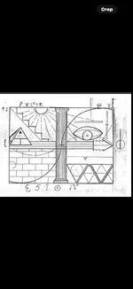
View attachment 2213911

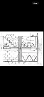
The orientation of the map is South at the top, North at the bottom, West on the right and East on the left.

The three large triangles in the lower right quadrant, represent the United States. The dot at the top of the center triangle is at 45deg 48' 47" N and 95deg 40' 18" W, the site of the Kensington Runestone, in Minnesota. Scott Wolter has written that in 1926 ten men initiated an effort to raise $300,000 to build a 204 foot obelisk that would house the Kensington Runestone. Eight of these ten men were Masons.

The dot in the center of the circle is at 42deg 35' 59" N and 109deg 38' 22" W.

The lower right corner of the center triangle is at 29deg 58' 45" N and 81deg 18' 44" W. This site is just north of St. Augustine, Florida which is one of the earliest Spanish settlements in what is now the United States. The latitude, at this point, is the same latitude as the Great Pyramid of Giza, Egypt.

The horizontal line that bisects two of the triangles varies between 37deg 41' N, on the left, and 37deg 23' N. on the right. On this latitude there are several treasure and treasure legend related sites. They are. the Beale Treasure, the Swift Treasure, Fort Knox Bullion Depository, Blanca Peak, Colorado and Treasure Mountain, Colorado. Further west, the latitude passes 13 miles north of the Four Corners Monument and into the Monument Valley of Utah.

I think this latitude was chosen because it is halfway between the latitude of the Kensington Runestone 45deg 48' N and the latitude of the Great Pyramid, 29deg 58' N, whose latitude is found just north of St. Augustine, Florida. The halfway point, between those two latitudes, is at 37deg 53' N, which is the latitude of the United States Bullion Depository at Fort Knox. This is interesting because Fort Knox is mentioned in Von Mueller's caption under the picture of the LUE map in Treasure Hunter's Manual #7. Something else of interest is found in Von Mueller's book Treasure of the Valley of Secrets. In his book, he mentions Blanca Peak, Treasure Mountain and Monument Valley, Utah, all places along the bisecting latitude.

Another place on this bisecting latitude is found on the west side of Blanca Peak. Von Mueller has written that the word LUE came from the first letters of three words written on the map, LLORO URRACA ENTERRARI, I cry, magpie, bury. I believe this phrase refers to the Pioneer Urraca Cemetery at the foot of Blanca Peak.

In the upper left quadrant of the LUE map are five steps that could be used to show latitude, each step would equal ten degrees. Five is also a number that is associated with the five petals on the red wild rose and the five wounds on Christ at the Cross. The red wild rose would represent the blood of Christ. Blanca Peak is located in a mountain range named Sangre de Christo, the blood of Christ. The steps on the LUE map could indicate the Sangre de Christo Mountains.

In the middle of the LUE map, where the quadrants join, there are four corners. These corners could indicate the Four Corners region of Colorado, New Mexico, Arizona and Utah.

In the upper left quadrant the Sun and it's rays should be considered a protractor. The rays show degree headings. The headings are 103.5, 119, 134, 150, 165, 180, 196, 210, 227, 242 and 257. Start these headings at the Kensington Runestone and the point in the circle location. Run the lines to the borders of the United States, using Google Earth or a table map that shows latitude and longitude as slightly curving lines. Two more starting points will be on the north side of Fort Knox and at a point 13 miles above the Four Corners Memorial. The intersections of these lines will create multiple locations on your map of the United States. Some of the intersections will be near areas associated with treasure legends. Some locations are at Socorro, New Mexico, The Spider Rock location in Texas, Wildcat Bluff, Arkansas and the Waterhouse Treasure legend of NE Georgia.

Many thanks to Randy Bradford for the LUE map information that he has shared over the years.

You will never get any where with this map unless you post the the right Lue map that contains the keys to unlock the window. You need to work with this map and I will walk you through unlocking the window.
 

Attachments

  • IMG_3397.webp
    IMG_3397.webp
    70.2 KB · Views: 65
The LUE cipher map is truly based on a window that was used in certain buildings in the 1930's especially in the military barracks. I know, I started my military career in 1979 and they were still using those type of windows. This windows were divided into four sections. The two lower sections sometimes were used for privacy and were not very clear plus they were always stationary. The upper half of the window could be unlock by moving the lock found in the center portion of the window. Unlocking the window would allow you to either push the upper half of the window open. In some windows you would have a handle that you would turn to open the window. So this cipher map was based on that specific type of window. The two upper sections of the window are the only ones that will allow you to look outside. The sun's rays on the LUE cipher map explains that the two upper sections of the window are clear and are the only two that will allow to see what is outside the window. Unlocking the window will allow you to see more of what is outside the window. Without the keys the window is just a square and you will never get out of that square. The opening of the window will give away the first part of a large area that is going to define a certain state because the map maker wants you to stay focus on the first part of the major map so you don't go wandering into left field. It is a cipher which hides the needed information to locate a treasure, but it's hidden information is no different in methods that you would find in most regular old instructional maps. Which means that in order to help someone find a treasure or a place? One needs to inform the receiver of the three things he is going, for sure need. That is the major area map, the general area map, and the immediate area map. When you deviate from common sense? And no one is going to listen to you! Because you make no sense!!!! It is a very crowded symbolic cipher and he intentionally ciphered too much but he did it to show how much knowledge he had obtained from certain books pertaining to the Templars plus he wanted to describe the some specifics of the venture. So, Bob Brewer knows that he is going to be wrong sometimes because he doesn't have all the answers to symbolic ciphering and that can happen to most who are looking for answers. He has a good character and he definitely means to do right by all. He definitely knows a good amount of ciphering and you could learn from him. I help those who need the help, but not those who want to help themselves.
 
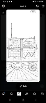
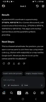
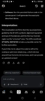
I put all this info into Grok ai and it spit out some strange stuff, no idea if helpful or not but here's what it came up with.
 

Attachments

  • IMG_3397.webp
    IMG_3397.webp
    70.2 KB · Views: 54
  • Screenshot_20250717_042457_X.webp
    Screenshot_20250717_042457_X.webp
    114.1 KB · Views: 51
  • Screenshot_20250717_042656_X.webp
    Screenshot_20250717_042656_X.webp
    109.9 KB · Views: 55
  • Screenshot_20250717_042816_X.webp
    Screenshot_20250717_042816_X.webp
    116.5 KB · Views: 56
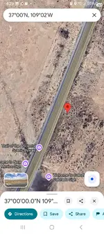
  • Screenshot_20250717_042928_Maps.webp
    Screenshot_20250717_042928_Maps.webp
    261.9 KB · Views: 53
I put all this info into Grok ai and it spit out some strange stuff, no idea if helpful or not but here's what it came up with.
Fun.
I did the same with open.ai
Screenshot_20250717_060822_Brave.webp
 
The LUE cipher map is truly based on a window that was used in certain buildings in the 1930's especially in the military barracks. I know, I started my military career in 1979 and they were still using those type of windows. This windows were divided into four sections. The two lower sections sometimes were used for privacy and were not very clear plus they were always stationary. The upper half of the window could be unlock by moving the lock found in the center portion of the window. Unlocking the window would allow you to either push the upper half of the window open. In some windows you would have a handle that you would turn to open the window. So this cipher map was based on that specific type of window. The two upper sections of the window are the only ones that will allow you to look outside. The sun's rays on the LUE cipher map explains that the two upper sections of the window are clear and are the only two that will allow to see what is outside the window. Unlocking the window will allow you to see more of what is outside the window. Without the keys the window is just a square and you will never get out of that square. The opening of the window will give away the first part of a large area that is going to define a certain state because the map maker wants you to stay focus on the first part of the major map so you don't go wandering into left field. It is a cipher which hides the needed information to locate a treasure, but it's hidden information is no different in methods that you would find in most regular old instructional maps. Which means that in order to help someone find a treasure or a place? One needs to inform the receiver of the three things he is going, for sure need. That is the major area map, the general area map, and the immediate area map. When you deviate from common sense? And no one is going to listen to you! Because you make no sense!!!! It is a very crowded symbolic cipher and he intentionally ciphered too much but he did it to show how much knowledge he had obtained from certain books pertaining to the Templars plus he wanted to describe the some specifics of the venture. So, Bob Brewer knows that he is going to be wrong sometimes because he doesn't have all the answers to symbolic ciphering and that can happen to most who are looking for answers. He has a good character and he definitely means to do right by all. He definitely knows a good amount of ciphering and you could learn from him. I help those who need the help, but not those who want to help themselves.
Here are the three things.

The major area map.

LUE starting points and lines.webp


The general area map.

smoke rock segment.webp


And the immediate area map.

smoke rock mountain.webp


This is Brewer's site at Smoke Rock Mountain where he made a recovery.
 
So.... I was playing around with the LUE map and chatgpt and, it said some things, I at least, found interesting. I prompted it for a while so for the sake of time, I'll just post the highlights......

Screenshot 2025-07-17 at 12.39.38 PM.webp
 
Screenshot 2025-07-17 at 12.52.52 PM.webp


I'm not saying it's right or wrong, but the current ai model at open.ai, ChatGPT40, had that to say....so far, and this is if you include the dollar bill part. I haven't tried leaving that part out yet, which I'll do now... The real test is to see if you can replicate those answers on your end with chatgpt. Someone give it a try! I used the map neo provided and let chatgpt pick any pre-1970 dollar it wanted....... you kinda gotta slow walk it and probe it, but that's what I got.
 
Last edited:
View attachment 2217250


I'm not saying it's right or wrong, but the current ai model at open.ai, ChatGPT40, had that to say....so far, and this is if you include the dollar bill part. I haven't tried leaving that part out yet, which I'll do now... The real test is to see if you can replicate those answers on your end with chatgpt. Someone give it a try! I used the map neo provided and let chatgpt pick any pre-1970 dollar it wanted....... you kinda gotta slow walk it and probe it, but that's what I got.
Real interesting stuff, Cuz. Thank you. I've never used the AI tech. How long did it take you to obtain all this information?
 
Real interesting stuff, Cuz. Thank you. I've never used the AI tech. How long did it take you to obtain all this information?
About 15 minutes.
 
Wow, that's fast.
If you're feeling spicy..... give it a shot!

click me then ask me things!!!! It's free, albeit you do help train the model with your questions.....

Off the bat it's not too useful, but you can train it.

Yesterday I asked it for an exhaustive search for something, and it turned up nothing. Then I searched for what I wanted and I found it. It was publicly available, digitized, and online. So I went back to that openai.com session and yelled at it, something like:
"I told you to do an exhaustive search and you told me there was nothing to see. However, I found 'this' online at 'here' and it's open access to the public, but you didn't find it. Can you do exhaustive searches or not?"
It replied something like:
"You are correct to point that out Joe. I did an exhaustive search of the websites I thought most likely to contain what you were looking for." (probably in an effort to conserve resources....but I work in power and the data center boom is keeping us real busy. :) So I don't care about its resources )
I then said:
"Ok now I want you to do an exhaustive search, of every public facing website for 'this.'

After that it turned up what I wanted and then some. So you gotta coax it along. It will give you really stupid answers sometimes with coordinates in another state and you gotta say, "bro, that was stupid, here's why....also, you will never be a human"............. and it'll refine itself and then all of a sudden it says something you hadn't thought of and...... off yer runnin!

It will also tailor its answers to your preferences and say things it thinks you want to hear, so you gotta reel it in sometimes. "Are you saying that because I had brought that up earlier..." Etc.. Keep it honest, as possible.
 
Last edited:

Users who are viewing this thread

Back
Top Bottom