"The Lue Map and the Nazi Connection -3"

Crow

Silver Member
Jan 28, 2005
3,325
9,295
In a tax haven some where
Detector(s) used
ONES THAT GO BEEP! :-)
Primary Interest:
Other
Some interesting stuff.

ironic with such conspiracy stories. there was a lot of ill feeling in 1890s with many banks failure taking peoples life savings and government of day saved and bailed out the top end of town with the average poor who lost money from banking collapses getting the short straw. sounds familiar? 2008!

The book by Walter hurt is horrid hard to read book to read as it is through the eyes of committed socialist that had his own personal vendetta on capitalism. interesting enough Walter Hurt wrote another book. The problem with the Jews. You can see where this was leading 30 odd year later in Germany?

These stories true or not true, leaking into the public imagination over time with each retelling. I cannot trust Walter Hurts book The scarlet shadow . As there is blend of fact and fiction mingled to to suit a personal agenda. To me the book was the rantings of a brain washed ideals inspired by Karl Marx on evils of capitalism.

That said the strange story of this cave in the book full of gold? Was it a fictional story for hurt to show the evils of such a folly linked to labor wars of Colorado in the late 19th early 20th century?

Strange enough my associate is no slouch when it comes to research. there was a cave allegedly discovered in 1923.

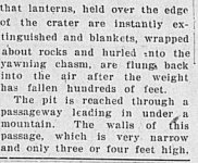
reference: San Pedro News pilot, 30 April 1923. - A bottomless pit and the legend of old Spanish mine, interest Colorado tourists. Article.

x1.jpg

x2.jpg


x3.jpg


x4.jpg


x5.jpg


Hurt described a in his book the Scarlet shadow. a bowl shaped valley with two entrances and cave somewhere near the headwaters purgatorie river in 1907.

The newspaper say volcanic crater the location

Coincidence?
 

Attachments

  • x3.jpg
    x3.jpg
    25.9 KB · Views: 5
Last edited:

Crow

Silver Member
Jan 28, 2005
3,325
9,295
In a tax haven some where
Detector(s) used
ONES THAT GO BEEP! :-)
Primary Interest:
Other
Interesting enough 4 years before Walter Hurt wrote the Scarlet Shadow. There was a conspiracy to high grade gold from the mines at cripple creek.

reference: The Daily Journal (Telluride ), July 21, 1905 - steal million dollars a year (Article)

The Daily Journal (Telluride), July 21, 1905 IIIF issue link — STEAL MILLION DOLLARS A YEAR [A...jpg

The Daily Journal (Telluride), July 21, 1905 IIIF issue link — STEAL MILLION DOLLARS A YEAR [A...JPG

The Daily Journal (Telluride), July 21, 1905 IIIF issue link — STEAL MILLION DOLLARS A YEAR [A...JPG

The Daily Journal (Telluride), July 21, 1905 IIIF issue link — STEAL MILLION DOLLARS A YEAR [A...JPG

So where was this alleged ranch?

Crow
 

Last edited:

Crow

Silver Member
Jan 28, 2005
3,325
9,295
In a tax haven some where
Detector(s) used
ONES THAT GO BEEP! :-)
Primary Interest:
Other
Walter Hurt's The Scarlet Shadow, published by The Appeal to Reason in 1907. Hurt's novel was based on the Western Federation of Miners' Colorado bombing case of 1905. In this case, IWW leader Big Bill Haywood, Charles Moyer, and George Pettibone were kidnapped in Denver and taken to Idaho to stand trial for the death by bombing of ex-Governor of Idaho Frank Steunenberg. The three were acquitted, partly due to the expert legal defense engineered by Clarence Darrow.

Assassination of Frank Steunenburg

Walter Hurt was reporter for Denver post in 1903 directory below.

walter hurt reporter denver post 1903.JPG


Walter Hurt was well aware of the cripple creek events, strikes etc and high grading and bombing.

Cripple Creek strike 1894

Colorado labor wars

He weaved it into a novel. All be it badly blending fact and fiction. So we have to question was the chapter 53 in his book the Scarlet shadow a real event or just a creation?

Karl Von Muller did not have luxury in his day to cross reference like we can today by getting access to newspapers.

Even so the fact remains not all of this high graded ore was every fully accounted for.

My apologies diverting from the topic of the Lue But its fairly obvious the lue is not connected to The Scartlet Shadow book. As Karl Von Muller maintained as Randy pointed out.

Crow
 

Last edited:

Crow

Silver Member
Jan 28, 2005
3,325
9,295
In a tax haven some where
Detector(s) used
ONES THAT GO BEEP! :-)
Primary Interest:
Other
Sdcfia

I like the phrase.

Some people are like Slinkys. They don't really have a purpose,
but they bring a smile to your face when you push them down the stairs.


That is what my ex bosses thought of me!
except I was not pushed down a stairs but under a bus!

Crow
:laughing7:
 

mdog

Bronze Member
Mar 22, 2011
2,348
4,404
The pyramid is Treasure Mountain. The five steps are the five peaks shown forming a pentagon. The column is the Mississippi River. The arrow shows three lines going east, with the middle line being the most important. To the east. the lines go to Oak Island (Money Pit), Montvale, Virginia (Beale Treasure) and Wildcat Bluff, Arkansas (Black Book Treasure). The middle line goes through the area of the gold cache. As you can see, the three lines pass over the upper, middle and lower peaks, all associated with treasure legends. To find the gold, you have to run a line from the bottom line, Wildcat Bluff, to the top line, Oak Island. That line will intersect the middle line at Fort Knox. I do believe that Von Mueller mentioned the LUE as being the natural Fort Knox.
lue 10.jpg
 

sdcfia

Silver Member
Sep 28, 2014
3,661
8,890
Primary Interest:
Other
Does this mean I get all the gold?
You bet, dog - you will have earned it. But save some crumbs for your pals.

Leave it to mdog to actually provide some plausible tools to use while pondering the "LUE". His application of axis mundi spherical geometry (ala Cort Lindahl) on numerous treasure related subjects years ago has had surprising results. By the way, Lindahl's earlier YT videos are highly recommended - they certainly widely opened my eyes to amazing locational "coincidences" worldwide. Since I don't believe in coincidences, I realized that, for many of the "treasure legends" we ponder in the US, there may well be a Unified Theory concerning the caches' owners and placements. The field clues found (carvings, et al) could all be local and diversionary, whereas the true mapping is all defined on higher level. As dog also demonstrated, certain place names (towns, landmarks, et al) are useful red flags and may occupy nodes on geometrical patterns. All you need is Google Earth Pro and a curious mind.

This all implies a highly organized conspiracy, of course. Is the "LUE" somehow just a part of a larger mix? Was Hammond's map just bait to entice Miller to create a cover story for another KGC cache? I don't have the answers, but I do have questions. Re the "LUE", it seems unlikely the KGC would select a Marxist theme for a cache, but if there's oil dripping from your engine, things can get confusing when you lift the hood.
 

mdog

Bronze Member
Mar 22, 2011
2,348
4,404
View attachment 2130771
Well, okay, let's continue. In the figure, as for the lines related to the rays of the sun, not all of them are like that. The lines that I indicated with arrows with a question mark, these lines simply represent the symbol that I colored, it reminds us of an arrow from a bow, where the red color is the tip of the arrow. Did you know that in the days when the main weapon was the bow, arrowheads had different and special purposes, that is, there were specialized arrowheads? So if not, ask. This photograph shows a very distinctive and very rare arrowhead. I looked through many of their options in all sources and finally came across this one, one on one. If you are interested, try searching the internet yourself and if you come across it, we will quickly continue the topic with you.
The column is the Mississippi River. The upper left quadrant shows that the five peaks are between Treasure Mountain and the rising Sun. The arrow shows three lines going east, with the middle line being the most important.
The lower right quadrant shows a map of the United States. The line, with the little triangle on it, is the Canadian border. The upper left point of the little triangle is Apple Lake, Minnesota. The top point of the middle triangle is the Kensington Runestone. The lower midpoint of that triangle is Center Point, Texas. The right side of the triangle on the right is the Atlantic coast. The left side of the triangle on the left is the Pacific coast. The circle inside the left triangle is a symbol for gold, most of the gold producing regions in the United States are in the western third of the country.
The lines going from west to east are great circle segments. They show the shortest distance between two points on the surface of a sphere.
 

sdcfia

Silver Member
Sep 28, 2014
3,661
8,890
Primary Interest:
Other
Sdcfia

I like the phrase.

Some people are like Slinkys. They don't really have a purpose,
but they bring a smile to your face when you push them down the stairs.


That is what my ex bosses thought of me!
except I was not pushed down a stairs but under a bus!

Crow
:laughing7:
Ouch! That oughta toughen up an old bird.
 

sdcfia

Silver Member
Sep 28, 2014
3,661
8,890
Primary Interest:
Other
The column is the Mississippi River. The upper left quadrant shows that the five peaks are between Treasure Mountain and the rising Sun. The arrow shows three lines going east, with the middle line being the most important.
The lower right quadrant shows a map of the United States. The line, with the little triangle on it, is the Canadian border. The upper left point of the little triangle is Apple Lake, Minnesota. The top point of the middle triangle is the Kensington Runestone. The lower midpoint of that triangle is Center Point, Texas. The right side of the triangle on the right is the Atlantic coast. The left side of the triangle on the left is the Pacific coast. The circle inside the left triangle is a symbol for gold, most of the gold producing regions in the United States are in the western third of the country.
The lines going from west to east are great circle segments. They show the shortest distance between two points on the surface of a sphere.
The Kensington Runestone (1362 CE) is an uber-important artifact and close to nearby Inspiration Peak, 400 feet above all surrounding terrain and the Point of Beginning of a remarkable early survey of today's continental United States. It's all detailed in the following website, which includes aerial photographs of the geoglyphs created as nodes of the survey. Was it a Land Claim?
https://www.thekensingtonrunestone.com/

KRS:IP.png
 

mdog

Bronze Member
Mar 22, 2011
2,348
4,404
I'm surprised that there are no questions about this mapping. This map shows three lines intersecting at the same spot, just above Fort Knox. The east/west line starts at Treasure Mountain, Colorado and goes to Montvale, Virginia (Beale Treasure). The SW/NE line connects Wildcat Bluff, Arkansas (Black Book Treasure) to Oak Island (Money Pit). The SE/NW line goes from Santa Elena, South Carolina to the site of the Kensington Runestone in Minnesota. Santa Elena was settled and fortified by the Spaniard Pedro Menendez de Aviles during the 1560s. He was one of the few men who organized and protected the Spanish treasure fleets that sailed from Cuba to Spain. I didn't choose the site of Santa Elena without reason. It has a connection to a treasure legend site further west. At any rate, the intersection of the three lines is exact.
santa elena.jpg
 

mdog

Bronze Member
Mar 22, 2011
2,348
4,404
I believe Von Mueller said that the LUE was 40 acres of gold, just under the ground. The bullion depository at Fort Knox sits on 42 acres and has a subterranean vault.
 

mdog

Bronze Member
Mar 22, 2011
2,348
4,404
I have more information that I can share, if it's ok with you, Sergei 3.
 

Randy Bradford

Hero Member
Jun 27, 2004
504
891
I believe Von Mueller said that the LUE was 40 acres of gold, just under the ground. The bullion depository at Fort Knox sits on 42 acres and has a subterranean vault.
Tom Hilton said the LUE was 40 acres, Karl did not. I've often wondered where Tom got the idea of the 40 acres. Karl did, however, call it a natural Fort Knox.
 

mdog

Bronze Member
Mar 22, 2011
2,348
4,404
Tom Hilton said the LUE was 40 acres, Karl did not. I've often wondered where Tom got the idea of the 40 acres. Karl did, however, call it a natural Fort Knox.
Thanks Randy. It would be interesting to know were he heard that because it would be a clue.
Was Von Mueller the person who said part of the LUE treasure was found by Black Lake, New Mexico at longitude 105 deg. 15'?
 

mdog

Bronze Member
Mar 22, 2011
2,348
4,404
By the way, if anyone wants to share their thoughts on this topic, but not for public viewing, then you can always write to me in a personal message.
In a personal message, they often send me all sorts of diagrams of sites, outlines of reliefs that resemble some individual fragments of the drawing of the “Lu map” (views from above, for example). Then I will answer everyone at once. No, the “Lu map” does not have any coincidences with the outlines on the ground, this is a completely different approach to determining the location of a place. Everything is built on symbolism.
Hi Sergei. The above is your 4th post so I'm going to take it as an invitation to share information.
 

Randy Bradford

Hero Member
Jun 27, 2004
504
891
Thanks Randy. It would be interesting to know were he heard that because it would be a clue.
Was Von Mueller the person who said part of the LUE treasure was found by Black Lake, New Mexico at longitude 105 deg. 15'?
Karl first mentioned the 105 degree 12.5 latitude parallel in the Treasure of the Valley of Secrets. I believe Tom Hilton might have been the first to publish this detail, however. Karl would refer to this clue repeatedly throughout his writing on the LUE over the years. Tom Hilton, interestingly, published this in a magazine article deeply critical of the LUE but would later write an article about the Beale treasure, where he makes a case for the mine Beale and co. dug their gold and silver being on the same parallel. I found his insistence on using the same clue with a completely different treasure interesting.

Tom Hilton was alleged by Karl in the NPG to have come to the Exanimo shop frequently during the height of the LUE craze and inferred that Hilton was prone to nagging for information and went as far as to camp in the mountains and spy on folks who were looking for LUE caches. It's worth noting that Long John Latham, who owned and published True Treasure and Treasure World published the Hilton article and repeatedly took shots at Karl in his editorials without naming Karl outright. Similarly, Hilton never credited Karl one bit with any aspect of the LUE story or as a source of information.

Karl did indicated multiple individuals recovered gold at Black Lake (near Eagle's Nest) New Mexico, but publicly I don't think he ever indicated he was one of them. Privately is another story. There were rumors for years that Karl did make that recovery and I have a letter Karl wrote himself admitting that he and Hardrock Hammond make a recovery in 1958. Karl mentions at least 6 other places where recoveries were made as well and speculated other locations were yet to be made.

One other thing about the 40 acres. The Black Lake caches were spread out over an indeterminate area in what Karl referred to as "pots." As I read it, many pots (implied to be roughly 100 pounds of ore or unrefined gold) were spread out over the area, relatively close to the surface...less than a foot deep if memory serves me correct. One can surmise these pots were buried in some sort of discernable configuration. Roy Roush speculated a KGC alignment with pots being laid out at regular intervals if one knew how to calibrate an overlay. My sense is that Karl did not have an overlay but rather found the area through the LUE map and used a metal detector to locate some of the smaller, individual pots. He complained a number of times about how the mineralization in the soil made operating a detector quite difficult and felt that was a large part of why Tom Hilton failed in locating any remaining treasure in the area.
 

Top Member Reactions

Users who are viewing this thread

Top