What's new

Oak Island Treasure Revelations

No one in their right mind would dig a pit even remotely like the one on OI to bury anything.
Especially Captain Kid.

To even suggest Captain Kidd had a hand at anything to do with what is called "the money pit"... would be purely imagination at its worse... and would show the lack of knowledge of CK's historical situation during that timeline.

No offense.
 
Even if you assume the Deadmans Island map is real (and it doesn't look even remotely real), the island looks nothing like Oak Island and the mainland is shown to be east of the island, not west. So this can't possibly represent Oak Island.

Do you have any actual evidence (non-confidential, or course) to otherwise support your hypothesis? For example, hard evidence that Kidd visited Oak Island, or that Kidd teamed up with Avery, or that a massive repository was constructed on OI. Anything? Or is it all based on "probability"?
Hi Carl-NC:
If you can get an enlarged copy of the Deadman Island Map so all the writing on it is clear it will give you a better picture of what I base my own opinion and theory on. The map does not look exactly the same as a satellite image of Oak Island although the west side is rounded the same and it's described as thickly wooded. You have to remember they did not have the benefit of a birds eye view and the east side of Oak Island might have looked different in their time, it is because it is constantly open to storms and powerful North Atlantic wave damaged. Frog island and Apple Island are also drawn on the map but given different names.
On the map it shows a tiny triangular pound and at the apex a fresh water stream runs through higher ground and down to the north through wet land, and then further on to an anchorage.
On Oak Island a triangular pond (reservoir) has a fresh water stream at the apex s it that runs north down to a wet swampy area and then to an anchorage in Joudary Cove. (The secret Jetty is shown in my book)
The great subterranean network of shafts (see CAD in my book) required hundreds of logs for its construction. For two years many logs were cut by Henry Every's men in a stockpile at Campeachy Bay, this located in the great Bay of Mexico. But he required many more logs. On the map Kidd strangely mentioned that a Spanish stock pile is located on the far side of Mahone Bay, "Here Spanish cut logs" This actual distant mainland area area does exist and it is depicted on the map but it is no where near to Oak Island. Why Kidd felt it necessary to add this information on the availability of logs on his treasure map is a real mystery, Henry Every needed to freight many logs to and unknown location for an unknown purpose and, was this just a coincidence or does it add credence to my theory of collusion between those two men.
Captain Kidd got over confident and admitted on the signed and dated map that he had taken Mogul treasure to Oak Island in the Adventure Price, and what's more where he moored that ship at the "Secret Jetty" located in Joudary Cove as described in my book.

My suggestion that Henry Every was the secret partner of William Kidd is my own hypothesis, is based what I consider to be sound evidence. Every had a lot of treasure yet he and his men spent two years cutting logs, what for if not to be used in the Oak Island mine. On Captain Kidd's map he clearly stated the location of logs, why mention that at all when he had transported treasure?

May I say to all who wish to have my opinion on anything appertaining to Oak Island, if you are polite I will always give you a truthful answer. The location of the "Loading Shaft", "Access Tunnel" and treasure filled "Repository" ( see CAD in the book) are confidential, and if the current searchers continue to feel that my unproven theories and offers to assist them are superfluous to requirements then sadly the treasure will probably never be found and recovered.

Please allow me to reiterate that I don't want any part of the treasure, and in 2025 I offered to help them if they in return got my book published. After waiting six weeks with no response I withdrew my offer, now it will cost them a lot or the treasure will probably stay hidden beneath Oak Island.

Oak Island Sage
 
Hi TruthbeTold:
1/ The factual evidence is shown on the Deadmans Island map.
I have to disagree that Dunfield debunked flood tunnels, the huge excavation he did with a huge Clam Digger to find the location of the Money Pit was plagued by sea water entering from - flood tunnels.
On the Oak Island Treasure website on Dunfeild's demise his son came under came under intense fire for the massive damage his father had made during his search. I came to his sons aid and pointed out that if his father had found treasure he would be considered a hero all sins forgiven, also if it wasn't for him there would be no causeway.
Oak Island Sage

I agree with Carl-NC that the deadman's map looks to be fake (unless you can provide actual evidence it isn't).

Dunfield excavated looking for flood tunnels from the fictional money pit area towards the swamp and found no flood tunnels.

Below is an actual letter from Dunfield stating that no flood tunnels were found and as everyone knows, the island has naturally occurring underground waterways:

IMG_0995.webp
 
Last edited:

Not quite true.

In May 2015, explorer Barry Clifford found a large silver bar (around 50kg/110lbs) off Madagascar's Sainte-Marie island, claiming it was from Captain Kidd's shipwreck, the Adventure Galley. However, UNESCO later determined the bar was mostly lead and the supposed shipwreck was likely dock construction debris, discrediting Clifford's sensational claims despite initial global excitement and presentation to Madagascar's President.

The sensationalized discovery was debunked by UNESCO, highlighting issues with scientific handling and premature claims. Barry Clifford, who also found the verified Whydah wreck, faced criticism for sensationalizing finds. Discrediting Clifford's sensational claims despite initial global excitement and presentation to Madagascar's President. The sensationalized discovery was debunked by UNESCO, highlighting issues with scientific handling and premature claims. Barry Clifford, who also found the verified Whydah wreck, faced criticism for sensationalizing finds.

The fact of the matter Kidd buried treasure at Gardiners island. And he mention treasure in saint Thomas to his jailers, 63 thousand pounds of treasure.

Screenshot 2026-01-12 102947.webp


But this is where facts fall away and fantasy takes over.


Crow
 
Thanks for the update Crow.

Your knowledge of historical treasures is 2nd to none.

Was Kidd’s sunken ship off of Madagascar ever found?

Is there any proof that the Gardiners accepted treasure from Kidd and then buried it on the island other than heresay?

Of course the oak island scam believers here will use your post to say it proves that treasure is on oak island. 🙄
 
Last edited:
Thanks for the update Crow.

Your knowledge of historical treasures is 2nd to none.

Was Kidd’s sunken ship off of Madagascar ever found?

Is there any proof that the Gardiners accepted treasure from Kidd and then buried it on the island other than heresay?

Of course the oak island scam believers here will use your post to say it proves that treasure is on oak island. 🙄
ZZZZZZZZZZZZZZZZŹZZZZZZZZ. YAUN. ZZZZZZZZZZZZZZZZZZZZZZZZZ. YAAAAAAAUN
 
I agree with Carl-NC that the deadman's map looks to be fake (unless you can provide actual evidence it isn't).

Dunfield excavated looking for flood tunnels from the fictional money pit area towards the swamp and found no flood tunnels.

Below is an actual letter from Dunfield stating that no flood tunnels were found and as everyone knows, the island has naturally occurring underground waterways:

View attachment 2240468
Thruthbetold:
This letter only shows that Dunfield did not personally identify the source of sea water as coming from excavated flood tunnels. As in my opinion the Chappell Shaft excavations did not connect with the original subterranean net work of flood tunnels, so I am not surprised that no flood tunnels were found by him. Incidentally the flood tunnels were approximately four feet high and two feet wide and filled with washed down beech stones they would not have been obvious during Dunfield's massive excavations.

I mean no offence but you are wrong, the Deadman Island map was genuinely drawn by the over confident Captain Kidd.
 
the flood tunnels were approximately four feet high and two feet wide and filled with washed down beech stones they would not have been obvious during Dunfield's massive excavations.
From my understanding of the Dunfield dig, he was primarily digging in just one spot. As he dug deeper the sides would slide down into where he was digging causing the cone shaped crater.

If you are correct that the tunnels were indeed 4x2, then they would would have been exposed as the dirt slid down around them and easily seen. Depending on how we’ll they held together, you could have 4, 5 or so feet of the "tunnel " sticking out of the side of pit.
 
From my understanding of the Dunfield dig, he was primarily digging in just one spot. As he dug deeper the sides would slide down into where he was digging causing the cone shaped crater.

If you are correct that the tunnels were indeed 4x2, then they would would have been exposed as the dirt slid down around them and easily seen. Depending on how we’ll they held together, you could have 4, 5 or so feet of the "tunnel " sticking out of the side of pit.
I should add...
If i remember correctly the top of the pit was 100ft across and at the bottom was very small; 15 to 20ft. Where he would have encountered the tunnels might have been maybe 30 ft across. It would have been at this point he would have hit wood and he would have known it because it would have been all dirt up to that point.

That doesn't mean he couldn't have missed it. Its probably just hard to hit a tunnel at 100ft as it is treasure vault.
 
I should add...
If i remember correctly the top of the pit was 100ft across and at the bottom was very small; 15 to 20ft. Where he would have encountered the tunnels might have been maybe 30 ft across. It would have been at this point he would have hit wood and he would have known it because it would have been all dirt up to that point.

That doesn't mean he couldn't have missed it. Its probably just hard to hit a tunnel at 100ft as it is treasure vault.
As i already stated, the Dunfield dig proves you cannot dig 100ft without the sides falling in so you need cribbing to support the walls and since none was reported, no one dug a shaft that deep before the Onslow company in 1803.

So flood tunnels is a moot point.
 
As i already stated, the Dunfield dig proves you cannot dig 100ft without the sides falling in so you need cribbing to support the walls and since none was reported, no one dug a shaft that deep before the Onslow company in 1803.

So flood tunnels is a moot point.
I agree that it's a moot point, but why could there not have been cribbing between the platforms (if these existed) before the space between them was filled in with soil? I appreciate the difficulty of removing the cribbing from the bottom up, but what if it was designed that way when the cribbing was introduced? So, surely, someone could have dug such a shaft to 110 feet before 1803.

R.V. Harris reports that a water bearing tunnel entering the pit excavations was recorded by two different operators at much the same depth (about 110 feet) both of whom agreed that it was well cut, man-made, and measured 4 feet by 2.5 feet. One report said that it was angled at 22.5 degrees (presumably upwards). Furthermore, the subsequent activities of each group were based on the existence of this tunnel, that is, they actually acted upon it as being fact and spent considerable time and money trying to block off the tunnel they'd encountered and thereby stop the flow of water.

It's all very well for some to declare that these people must have been lying, because of Dunfield's observations, but as far as I'm aware Dunfield didn't actually say that his observations proved that there was never a water bearing tunnel, just that he didn't see one. Could such a tunnel have collapsed?
 
I agree that it's a moot point, but why could there not have been cribbing between the platforms (if these existed) before the space between them was filled in with soil? I appreciate the difficulty of removing the cribbing from the bottom up, but what if it was designed that way when the cribbing was introduced? So, surely, someone could have dug such a shaft to 110 feet before 1803.

R.V. Harris reports that a water bearing tunnel entering the pit excavations was recorded by two different operators at much the same depth (about 110 feet) both of whom agreed that it was well cut, man-made, and measured 4 feet by 2.5 feet. One report said that it was angled at 22.5 degrees (presumably upwards). Furthermore, the subsequent activities of each group were based on the existence of this tunnel, that is, they actually acted upon it as being fact and spent considerable time and money trying to block off the tunnel they'd encountered and thereby stop the flow of water.

It's all very well for some to declare that these people must have been lying, because of Dunfield's observations, but as far as I'm aware Dunfield didn't actually say that his observations proved that there was never a water bearing tunnel, just that he didn't see one. Could such a tunnel have collapsed?
From my research, the process of cribbing used at the time is as follows...

Method 1: You dig a hole and stack prefabricated frames the size of the shaft on top of each other.

As digging continues, the cribbing keeps moving down and a new prefabricated frame is placed on top.

Method 2: Another method used...after digging a hole, precut logs were lowered down and the frame is built in the bottom of the shaft, and stacked on top of each other before they are pinned in place. They continued digging down, framed the next section and pinned it in place.

Platforms for both methods were attached inside the cribbing to allow largest possible opening to traverse the shaft and lift and lower buckets.

In both cases, the weight of the cribbing rests on top of each other making difficult to remove from the bottom up. So if someone wanted to hide their shaft they'd remove the top 10 or 20ft, lay a platform across the top and fill with dirt. They would never think about removing the cribbing because of danger and effort envolved.

This is the same method used by Chappels shaft shown in the picture i attach earlier in this thread.

Could someone have used another method? Maybe.
Lets suppose they dug down 10ft and laid a platform into the sides of the hole and then cribbed the sides resting on the platform. This would imply the platform covers the entire hole, so how would they get below the platform to dig deeper.
I guess you'd have to cut an opening in the middle.
Since the shaft was 12ft in diameter, how big can you make the hole. 3ft, 4ft square?
A bigger hole means you need to re-enforce the platforms.

So lets say they did this. its a lot of effort and danger to remove the wall cribbing and replacing cut logs for the opening with full logs.

Ive never cribbed a shaft and i had a hard time finding out how they cribbed before 1800 so if some knows more or finds my description wrong, you will in no way hurt my feelings.

With regards to the 4x2.5 tunnel, i don't know but i can only make one comment...they used cribbing to get down there to find it.

One last thought...how did dan blankenship stack those tanker cars when he dug 10X? I think Method 1 was used.

Maybe Old Sage can tell us since spoke to dan.
 
Thruthbetold:
This letter only shows that Dunfield did not personally identify the source of sea water as coming from excavated flood tunnels. As in my opinion the Chappell Shaft excavations did not connect with the original subterranean net work of flood tunnels, so I am not surprised that no flood tunnels were found by him. Incidentally the flood tunnels were approximately four feet high and two feet wide and filled with washed down beech stones they would not have been obvious during Dunfield's massive excavations.

I mean no offence but you are wrong, the Deadman Island map was genuinely drawn by the over confident Captain Kidd.

When previous diggers encountered water running in the the sides they always attributed it to mysterious flood tunnels when in fact, it was just one of the many natural underground water passages that run under the island.

ZERO factual proof has ever be presented regarding manmade flooed tunnels on oak island.

Please provide your factual evidence that the deadman’s map was drawn by Kidd.
 
As i already stated, the Dunfield dig proves you cannot dig 100ft without the sides falling in so you need cribbing to support the walls and since none was reported, no one dug a shaft that deep before the Onslow company in 1803.

Maybe. On the other hand, upwards of 15 shafts had been dug in or around the Money Pit by the turn of the century, so Dunfield was very likely not excavating virgin clayish till, he was digging in pre-worked earth by that point, which probably gave it very different collapse properties.

--GT
 
Maybe. On the other hand, upwards of 15 shafts had been dug in or around the Money Pit by the turn of the century, so Dunfield was very likely not excavating virgin clayish till, he was digging in pre-worked earth by that point, which probably gave it very different collapse properties.

--GT
He was not digging in the MP but 50ft or more SW of it.

The Restalls identified where they thought the flood tunnels were and dropped a shaft with cribbing looking for them. That's when they encountered gas and died. Dunfield dropped his bucket on that shaft picking up where they left off.

Some of the till he dug was probably worked earth but most of it was probably clayish till.

Having said that, im not sure clayish till is adequate to dig a 90ft shalt without cribbing. In order to do that, you need CLAY but even then, when clay is saturated with water it turns into a sloppy mess so they would have needed some kind of support once they got below sea level...35ft i think.

Once again, if this info in wrong, you will not hurt my feelings if you call me out. In fact i would be appreciative of the correct answer(s).
 
Please provide your factual evidence that the deadman’s map was drawn by Kidd.
None is presented in the book nor does he present a shred of evidence here. Most of his book is fallacious argument by assertion.

"Arguing by assertion (aka proof by assertion, bare assertion) is a logical fallacy where someone tries to prove a claim is true simply by stating it repeatedly or emphatically, without providing actual evidence." :BangHead:
 
Maybe. On the other hand, upwards of 15 shafts had been dug in or around the Money Pit by the turn of the century, so Dunfield was very likely not excavating virgin clayish till, he was digging in pre-worked earth by that point, which probably gave it very different collapse properties.

--GT
Here's what google AI says...
You can often dig a few feet into clayish till before sides collapse, especially if it's moist, but depth depends heavily on moisture (wet clay slumps) and compaction (hardpan stops you); generally, vertical walls are risky beyond 2-3 feet, requiring a wide, sloped bank (3:1 ratio) or shoring for deeper excavations, as clay's tendency to hold water and crack makes stability unpredictable for deep, narrow holes.

My original research indicated you could dig 30ft before it gets dangerous and why i believe the first part of the story about the 3 boys could be true.
 
He was not digging in the MP but 50ft or more SW of it.

That might have been enough to take him out of the pre-worked zone, but difficult to say for sure. OITCo was venturing at least as far as 25 feet from the MP proper with their shafts, along with Cave-In Pit excavations and shafts along the purported flood tunnel route, all before 1899. It's possible that Dunfield's crater did not collapse evenly all round the circle, but had weak spots where it intersected prior digs.

--GT
 
That might have been enough to take him out of the pre-worked zone, but difficult to say for sure. OITCo was venturing at least as far as 25 feet from the MP proper with their shafts, along with Cave-In Pit excavations and shafts along the purported flood tunnel route, all before 1899. It's possible that Dunfield's crater did not collapse evenly all round the circle, but had weak spots where it intersected prior digs.

--GT
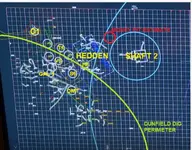
The attach diagram shows the perimeter of the Dunfield dig in green. The center of his dig is off screen lower left.
The till near the upper right would be worked till but at the center it seems it would be original till.
 

Attachments

  • Screenshot_20250707_152541_Chrome~2.webp
    Screenshot_20250707_152541_Chrome~2.webp
    104.2 KB · Views: 54

Users who are viewing this thread

Back
Top Bottom