What's new

LUE MAP CLUES

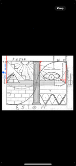
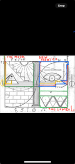
I'm pretty sure some of you were successful in opening the window. The map maker uses symbolic symbols to explain what he wants done without using words. Just like the story Maddog posted of the civil war soldier who was plotting coordinates without using numbers or words. I think that shorthand is related to ciphering. A symbol can carry many meanings and can deliver multiple messages. Let's look at the messages that the map maker is giving us? The window is unlocked for you, to open the window. Look to the right and follow the pointer which is pointing to two movable lines and a rotating symbolic symbol that looks like a handle. The pointer is pointing and also telling you up to what point to crack open the window. The two lines are going to assist the pointer to accomplish this cipher message. Rotate the first line to the left hand side of the window in the exact angle it has been drawn. The line will angle towards the outside of the window to help in deciphering several other clues located outside the window. Then rotate the second faded line located outside the right hand side of the window which contains a small corner turn at the top touching the window frame. Because it's touching the window frame? You must rotate it to the inside of the window, but do not draw the line past the pointer because the lines and the pointer work together to define how far the window will be cracked open. The dollar bill is going to clue you in on the fact that similar symbols can be used in differently ways to deliver different messages, but the symbolic application on the dollar bill will not apply to this cipher message. As mentioned before, the second line will be drawn inside the right window panel to help decipher the next clues. This begins the treasure hunt because the window is now open. The map maker can now explain what lies outside the window. Remember to stay focus? This is a map to a treasure and the map maker has to guide you to it step by step starting with the most important question you have been asking? Where do we start? Give us the starting point? The starting point is on the right hand window panel. The setup is in place and the focus is in the right hand corner of the panel. Now you're able to see the square corner indentation that you can fine on the right hand corner outline of the state of New Mexico. But the map maker wants to make sure that you understand what he saying and therefore he added more clues to his cipher to help you understand his message clearly. So he wants you to start on the right hand corner and follow the towards left then down catching another that leads to the right in order to map out something that looks like the state of New Mexico. but wait! There's a problem in the way? There's a line drawn improperly! If you look closely, the line contains two small round circles one on each end. This a trick! A movable line that contracts and expands using a rolling bearing attached to the window frame. This map maker is over doing his ciphering? He is just showing off how much he knows about ciphering. Once you adjust the line horizontal you will be able to come out with an outline that looks like the state of New Mexico. But the map maker knows that one example will not be enough! When it comes to ciphering based on Templar ciphering knowledge! The Templars understood that ciphering primarily is made to deceive the enemy and they created a method which I call the tri-method. It's a secret way of delivering the same message three times which the enemy does not understand. So he added several lines to accomplish his tri-method of messaging. which means you can draw the outline of the state of New Mexico three different ways by substituting a line or two. Some of you stuck to your common sense and never left beyond the borders of New Mexico. Even though you're not done with the extra clues on the right upper window panel. The map maker is taking you to the next step which is the second map on the upper left window panel. This one will be simple for you because it follows the same method as the first map. Find the three hooks that represent the hook of New Mexico. The not stop until you find third hook because it's well hidden. The next step will be defining the third map that focuses on the immediate area located in the lower right window panel. This panel explains more than just the map. It explains part of the story of how they got the gold there. This is where it gets very interesting. This is where you say you don't need me any more? If? You know how to decipher the rest of the map? But historians would like to know how symbols are used and how the story played out to record things they didn't know? How is this related to Leon Trabuco's gold? Well, you can learn more as I decipher the map the way the map maker explains.
 
By the way! What about the pillar? Yeah! I missed that, so I'm going to bring that up! Before anybody brings it up! Symbols are used to take place of actual things to hide their appearance like a locking mechanism that looks like a sine wave or a rotating instrument in place of a handle, or a pillar instead of basic outline of a square window panel. But for some reason the map maker uses the pillar, not only to hide the outline of a window, but to also use part the pillar to set up another clue like a hook resembling the hook of New Mexico on the left upper window panel. But what is the relationship of the pillar to the outline of the state of New Mexico symbolically speaking? You may think? Well, the base of a pillar is made out of stone and so is the top cap. If you go to the southwest corner of New Mexico? You might notice that the ground base is hard and rocky. If you go to the northwest corner of New Mexico? You might find Rocky Mountains? At least that's what the map maker is saying! Is this true? Did he know that? Did he venture to the southwest of New Mexico as well as the northwest corner of New Mexico? The story floating around about Trabuco does mention the northwest. This cipher map mentions the southwest. The connection between those two are going to come together at some point of the LUE cipher map story.
 
In an attempt to simplify the information that I shared in my thread LUE MAP THEORY, MAYBE SOME CONTEXT, I decided to start this thread. I'll keep it brief.

View attachment 2213911

The orientation of the map is South at the top, North at the bottom, West on the right and East on the left.

The three large triangles in the lower right quadrant, represent the United States. The dot at the top of the center triangle is at 45deg 48' 47" N and 95deg 40' 18" W, the site of the Kensington Runestone, in Minnesota. Scott Wolter has written that in 1926 ten men initiated an effort to raise $300,000 to build a 204 foot obelisk that would house the Kensington Runestone. Eight of these ten men were Masons.

The dot in the center of the circle is at 42deg 35' 59" N and 109deg 38' 22" W.

The lower right corner of the center triangle is at 29deg 58' 45" N and 81deg 18' 44" W. This site is just north of St. Augustine, Florida which is one of the earliest Spanish settlements in what is now the United States. The latitude, at this point, is the same latitude as the Great Pyramid of Giza, Egypt.

The horizontal line that bisects two of the triangles varies between 37deg 41' N, on the left, and 37deg 23' N. on the right. On this latitude there are several treasure and treasure legend related sites. They are. the Beale Treasure, the Swift Treasure, Fort Knox Bullion Depository, Blanca Peak, Colorado and Treasure Mountain, Colorado. Further west, the latitude passes 13 miles north of the Four Corners Monument and into the Monument Valley of Utah.

I think this latitude was chosen because it is halfway between the latitude of the Kensington Runestone 45deg 48' N and the latitude of the Great Pyramid, 29deg 58' N, whose latitude is found just north of St. Augustine, Florida. The halfway point, between those two latitudes, is at 37deg 53' N, which is the latitude of the United States Bullion Depository at Fort Knox. This is interesting because Fort Knox is mentioned in Von Mueller's caption under the picture of the LUE map in Treasure Hunter's Manual #7. Something else of interest is found in Von Mueller's book Treasure of the Valley of Secrets. In his book, he mentions Blanca Peak, Treasure Mountain and Monument Valley, Utah, all places along the bisecting latitude.

Another place on this bisecting latitude is found on the west side of Blanca Peak. Von Mueller has written that the word LUE came from the first letters of three words written on the map, LLORO URRACA ENTERRARI, I cry, magpie, bury. I believe this phrase refers to the Pioneer Urraca Cemetery at the foot of Blanca Peak.

In the upper left quadrant of the LUE map are five steps that could be used to show latitude, each step would equal ten degrees. Five is also a number that is associated with the five petals on the red wild rose and the five wounds on Christ at the Cross. The red wild rose would represent the blood of Christ. Blanca Peak is located in a mountain range named Sangre de Christo, the blood of Christ. The steps on the LUE map could indicate the Sangre de Christo Mountains.

In the middle of the LUE map, where the quadrants join, there are four corners. These corners could indicate the Four Corners region of Colorado, New Mexico, Arizona and Utah.

In the upper left quadrant the Sun and it's rays should be considered a protractor. The rays show degree headings. The headings are 103.5, 119, 134, 150, 165, 180, 196, 210, 227, 242 and 257. Start these headings at the Kensington Runestone and the point in the circle location. Run the lines to the borders of the United States, using Google Earth or a table map that shows latitude and longitude as slightly curving lines. Two more starting points will be on the north side of Fort Knox and at a point 13 miles above the Four Corners Memorial. The intersections of these lines will create multiple locations on your map of the United States. Some of the intersections will be near areas associated with treasure legends. Some locations are at Socorro, New Mexico, The Spider Rock location in Texas, Wildcat Bluff, Arkansas and the Waterhouse Treasure legend of NE Georgia.

Many thanks to Randy Bradford for the LUE map information that he has shared over the years.
lue coor 2.webp

This drawing shows how the steps in the upper left quadrant can be used to find latitude and how the shallow curve on the right side of the map can be used to find longitude. It also shows an interesting connection between the Kensington Runestone and the star Capella. I wonder what the creators of the Kensington Runestone called it, maybe they called it Capella. Capella can be seen all night long and all year long, at latitudes above 44 degrees north. It could be useful as a navigating reference. Capella could also have a Masonic connection. Masonic tracing boards have two stars, the Sun and another Blazing Star. The Sun can be seen in the upper left quadrant, so maybe Capella was meant to represent the Blazing Star in the upper right quadrant. Maybe our supporting Mason, Cuz, can share his thoughts about that. Thank you.

The drawing also shows how the horizontal and vertical bars in the upper right quadrant can be used to find latitude and longitude. The horizontal bar can be used to find the longitude of the Kensington Runestone, but, if you move the horizontal bar up and to the right, so that it fills the gap in the vertical bar, you get the 45 degree latitude of the Kensington Runestone and the star Capella as well as the longitude of Capella.

The three large triangles in the lower right quadrant of the map, represent the United States. The dot at the top of the center triangle is at 45deg 48' 47" N and 95deg 40' 18" W, the site of the Kensington Runestone, in Minnesota.

The lower right corner of the center triangle is at 29deg 58' 45" N and 81deg 18' 44" W. This site is just north of St. Augustine, Florida which is one of the earliest Spanish settlements in what is now the United States. The latitude, at this point, is the same latitude as the Great Pyramid of Giza, Egypt. On the drawing, I ran a line from the top of the pyramid to the steps, to find the pyramid's latitude of 29 deg.

The 37 deg. latitude is at the halfway point between the latitudes of 45 deg. and 29 deg.
 
View attachment 2218427
This drawing shows how the steps in the upper left quadrant can be used to find latitude and how the shallow curve on the right side of the map can be used to find longitude. It also shows an interesting connection between the Kensington Runestone and the star Capella. I wonder what the creators of the Kensington Runestone called it, maybe they called it Capella. Capella can be seen all night long and all year long, at latitudes above 44 degrees north. It could be useful as a navigating reference. Capella could also have a Masonic connection. Masonic tracing boards have two stars, the Sun and another Blazing Star. The Sun can be seen in the upper left quadrant, so maybe Capella was meant to represent the Blazing Star in the upper right quadrant. Maybe our supporting Mason, Cuz, can share his thoughts about that. Thank you.

The drawing also shows how the horizontal and vertical bars in the upper right quadrant can be used to find latitude and longitude. The horizontal bar can be used to find the longitude of the Kensington Runestone, but, if you move the horizontal bar up and to the right, so that it fills the gap in the vertical bar, you get the 45 degree latitude of the Kensington Runestone and the star Capella as well as the longitude of Capella.

The three large triangles in the lower right quadrant of the map, represent the United States. The dot at the top of the center triangle is at 45deg 48' 47" N and 95deg 40' 18" W, the site of the Kensington Runestone, in Minnesota.

The lower right corner of the center triangle is at 29deg 58' 45" N and 81deg 18' 44" W. This site is just north of St. Augustine, Florida which is one of the earliest Spanish settlements in what is now the United States. The latitude, at this point, is the same latitude as the Great Pyramid of Giza, Egypt. On the drawing, I ran a line from the top of the pyramid to the steps, to find the pyramid's latitude of 29 deg.

The 37 deg. latitude is at the halfway point between the latitudes of 45 deg. and 29 deg.

Ya slap me.
Looking at your bar(s) I keep wanting to slide the pyramid .

Time and or location viewed from ; changes the sun. Star. Moon position perspective/location.
No I don't see where time is given.( Like I see little enough as is.)

Two compass divider footprints want chased and expanded. Like ; the top one to each step of the 5 to the N.W..
Or the lower one the same (N.W.) direction all the way through the N.W. lower block of the pyramid. Only circling where a straight line indicates intersections of lines. Through intersections. Are there 5 again like the steps?

Both upper and lower have E.W. indications. The corners of the lower compass foots mark circled's triangle it is housed ins upper corners. And the ends of the "football" in the upper.

E.W. can be movement of sun or moon given time of year. With tilts granted in seasons of sun like more South in our area in winter but still tracking W.E.. Getting the moon more dependable; limits dates.
[When the Moon is full, it rises close to due east and sets close to due west on those dates nearest the Vernal and Fall Equinoxes. In fact, when the Moon is full, it’s nearly opposite the setting Sun. As you watch the Sun set, turn around and you’ll find the full Moon rising.]

LUE moon?
Sing it Frankie!

"And then there suddenly appeared before me
The only one my arms will hold
I heard somebody whisper, "Please, adore me"
And when I looked, the moon had turned to gold
Blue moon"


1753546522363.webp
 
Last edited:
Ya slap me.
Looking at your bar(s) I keep wanting to slide the pyramid .

Time and or location viewed from ; changes the sun. Star. Moon position perspective/location.
No I don't see where time is given.( Like I see little enough as is.)

Two compass divider footprints want chased and expanded. Like ; the top one to each step of the 5 to the N.W..
Or the lower one the same (N.W.) direction all the way through the N.W. lower block of the pyramid. Only circling where a straight line indicates intersections of lines. Through intersections. Are there 5 again like the steps?

Both upper and lower have E.W. indications. The corners of the lower compass foots mark circled's triangle it is housed ins upper corners. And the ends of the "football" in the upper.

E.W. can be movement of sun or moon given time of year. With tilts granted in seasons of sun like more South in our area in winter but still tracking W.E.. Getting the moon more dependable; limits dates.
[When the Moon is full, it rises close to due east and sets close to due west on those dates nearest the Vernal and Fall Equinoxes. In fact, when the Moon is full, it’s nearly opposite the setting Sun. As you watch the Sun set, turn around and you’ll find the full Moon rising.]

LUE moon?
Sing it Frankie!

"And then there suddenly appeared before me
The only one my arms will hold
I heard somebody whisper, "Please, adore me"
And when I looked, the moon had turned to gold
Blue moon"


View attachment 2218438
I've been looking for a treasure connection with the star Capella and have only found a couple. I remember, years ago, L.C. Baker posted a picture of a cross with Capella carved on it. I believe he used it to navigate to a clue on his trail.

Another mention was in a long article titled The Great Lost Treasure. Sdcfia has posted the article, in the past. The star, Capella, was mentioned as part of a treasure legend. https://thegreatlosttreasure.info/

Here's a Greek myth that I found using AI. "
  • The cornucopia connection: In Greek mythology, Capella is the goat whose broken horn became the cornucopia, a horn of plenty that could be filled with anything its owner desired. This links the star to the concept of abundance and fulfillment of desires, which could be interpreted as a form of "treasure".
I suppose this could apply to the LUE and it's abundance of treasure.
 
I've been looking for a treasure connection with the star Capella and have only found a couple. I remember, years ago, L.C. Baker posted a picture of a cross with Capella carved on it. I believe he used it to navigate to a clue on his trail.

Another mention was in a long article titled The Great Lost Treasure. Sdcfia has posted the article, in the past. The star, Capella, was mentioned as part of a treasure legend. https://thegreatlosttreasure.info/

Here's a Greek myth that I found using AI. "
  • The cornucopia connection: In Greek mythology, Capella is the goat whose broken horn became the cornucopia, a horn of plenty that could be filled with anything its owner desired. This links the star to the concept of abundance and fulfillment of desires, which could be interpreted as a form of "treasure".
I suppose this could apply to the LUE and it's abundance of treasure.
Capella as the cornucopia could be the link to the Masons. Here's more information from AI.

In Freemasonry, the Cornucopia, or Horn of Plenty, is a prominent symbol of abundance and prosperity. It is particularly associated with the Masonic Stewards, who wear it on their collars as the jewel of their office.
The symbolism extends beyond material wealth to encompass the idea of a universal spiritual abundance that Masons are encouraged to embrace and share.

Significance in Freemasonry
  • Abundance and Nourishment: The Cornucopia serves as a reminder of the duty of the Stewards to ensure the well-being and comfort of their fellow Lodge members, especially during refreshment. This includes providing for their physical needs, such as meals, but also extends to fostering a spirit of generosity and sharing within the Masonic community.
  • Hospitality: The Cornucopia symbolizes hospitality and the importance of creating a welcoming and supportive environment within the Lodge.
  • Spiritual Abundance: Beyond material plenty, the Cornucopia represents a spiritual richness and the abundance of divine guidance and universal knowledge available to Masons on their path of self-improvement and enlightenment. It encourages Masons to seek awareness and growth beyond the material realm, striving for a better humanity.
  • Continuity and Gratitude: The cornucopia's symbolic history, originating from the myth of Zeus and Amalthea, emphasizes unending sustenance and the bountiful gifts of nature, according to freemasonry.wiki. In Freemasonry, this resonates with the importance of gratitude for blessings and the continuous pursuit of knowledge and personal development.
  • In essence, the Masonic Cornucopia transcends a purely material interpretation to embrace a holistic view of abundance, encompassing physical well-being, spiritual growth, and the cultivation of generosity and fraternal bonds within the Masonic brotherhood.
 
I've been looking for a treasure connection with the star Capella and have only found a couple. I remember, years ago, L.C. Baker posted a picture of a cross with Capella carved on it. I believe he used it to navigate to a clue on his trail.

Another mention was in a long article titled The Great Lost Treasure. Sdcfia has posted the article, in the past. The star, Capella, was mentioned as part of a treasure legend. https://thegreatlosttreasure.info/

Here's a Greek myth that I found using AI. "
  • The cornucopia connection: In Greek mythology, Capella is the goat whose broken horn became the cornucopia, a horn of plenty that could be filled with anything its owner desired. This links the star to the concept of abundance and fulfillment of desires, which could be interpreted as a form of "treasure".
I suppose this could apply to the LUE and it's abundance of treasure.

Nationality origin forgotten if known prior.... A hot place perhaps.
A co-workers wish for those meaning well was "may your basket always be full".
And in many countries that is being rich.

I'd need a pile of map copies to mark up to use a compass and see what circles become as the map would be gone past at points. Leaving radio wave arcs.
Then choose a time or place.
If the compass heading along intersections at intervals aligned with triangle corner to pyramid involve it's (the pyramids/capstones as indicted) shadow that might help.
Then toss time and look at straighter curves vs half circle types for longitude and latitude. Then lines.....

1753632533224.webp

Auriga as depicted in Urania’s Mirror, a set of constellation cards published in London circa 1825. Capella, the Goat Star, is a goat that the Charioteer carries on his shoulder. Notice the 2 baby goats – known as The Kids – at the larger goat’s feet. Image via Wikipedia (public domain).
 
Nationality origin forgotten if known prior.... A hot place perhaps.
A co-workers wish for those meaning well was "may your basket always be full".
And in many countries that is being rich.

I'd need a pile of map copies to mark up to use a compass and see what circles become as the map would be gone past at points. Leaving radio wave arcs.
Then choose a time or place.
If the compass heading along intersections at intervals aligned with triangle corner to pyramid involve it's (the pyramids/capstones as indicted) shadow that might help.
Then toss time and look at straighter curves vs half circle types for longitude and latitude. Then lines.....

View attachment 2218576
Auriga as depicted in Urania’s Mirror, a set of constellation cards published in London circa 1825. Capella, the Goat Star, is a goat that the Charioteer carries on his shoulder. Notice the 2 baby goats – known as The Kids – at the larger goat’s feet. Image via Wikipedia (public domain).
As a treasure map, the LUE map is probably obsolete, but as an historic Masonic artifact, it's an amazing record of Masonic lore. I'd love to see the original.

In post 63, I showed how the coordinates of the Kensington Runestone and the terrestrial coordinates of the star Capella can be found, by looking at information found in the upper right quadrant of the LUE map. I was looking for evidence that would show why the coordinates of Capella would be on the LUE map, when I found information that Capella could represent the cornucopia, the horn of plenty. Further investigation showed that two officers, in a Masonic Temple, the Senior Steward and the Junior Steward, have identical jewels of the cornucopia.

Senior Steward – Duties​

His Jewel is the Cornucopia, which is an exact duplicate of the Junior Steward’s Cornucopia. The Cornucopia signifies the “Horn of Plenty”. It is a goat horn filled with fresh fruits and vegetables to denote the “fruits of your labors” and represents a job well done. The Senior Steward sits to the right of the Junior Warden in the South.

The Senior Steward of a Masonic Lodge is an appointed officer of the Lodge.

The Senior Steward is tasked to understudy the Junior Deacon’s position and fill in for the Junior Deacon when absent.

The Junior Deacon’s principal role is to prepare the candidates during ritual and escort them to the lodge room and assist the Senior Deacon. In their entry Officer positions, both the Senior and Junior Stewards handle kitchen duties and wait staff for the members.
jewel-stewards.png

Junior Steward – Duties​

His Jewel is the Cornucopia, which is an exact duplicate to the Senior Steward’s Cornucopia. The Cornucopia signifies the “Horn of Plenty”. The Junior Steward sits to the left of the Junior Warden in the South.

It is a goat horn filled with the “fruits of your labors” and represents a job well done.

The Junior Steward of a Masonic Lodge is an appointed officer of the Lodge.

The Junior Steward is tasked to understudy the Senior Steward position and fill in for the Senior Steward in his absence. The Junior Steward’s principle role is to assist the Senior Steward and the Senior Deacon in the preparation of the Candidates.

Both the Senior and Junior Stewards carry rods, atop which are the jewels of their offices. The rods represent England’s Lord High Steward’s rod in the House of Lords.

Mdog here. Something else of interest is that both stewards sit on the south side of the Masonic Temple and the LUE map is oriented with south at the top, where the coordinates of the KRS and Capella are found. This picture shows how a British Masonic Temple is set up, notice that the Temple is oriented with south at the top. We know that south is at the top because the two seats occupied by the Senior and Junior Stewards are in the south of the Temple and those seats are shown at the top of the picture.

British Lodge.webp


lue coor 2.webp
 
A symbolic treasure cipher map is made with the intention to deceive first and secondary to deliver hidden step by step information based on clues that help find X marks the spot where a treasure is buried or placed. A cipher map maker has to consider how far to zoom out in order to draw confusion. In the 1930's there were many people living in New Mexico and because of the many eyes around the area in question? The map maker had to zoom out to be able to bring attention and focus on the four corners that connect four states by using a four window panel window style map. It's the reason why many individuals thought of the four corners initially referencing the four corners that come together in the central part of the window. This setup, trick, or trap? Was used by the map maker to draw treasure hunters away from the area where the treasure was buried. If you don't open the window? You will be stuck inside the window and it won't matter if your able to decipher lots of clues because you will never find the connection that they have with each other if you get stuck inside the window to also include that you will never find the immediate area. The most important information in breaking a treasure cipher is to locate the immediate area. Not opening the window will only help you become part of the statistics of those who tried and die trying. Opening the window will expose the three maps that you need in order to find the immediate location. I found the Immediate location by using the skill and knowledge that I had obtained by studying other pirates who had created cipher maps before I ran into the LUE cipher map containing the keys or clues to open the window. I employed reverse engineering in deciphering the whole LUE map cipher. Because again, as I said before, you need the immediate area to break the code or clues. The one thing that the map maker knows for sure? Is? That you need to find the immediate location and you need to take the map with you to be able to break the clues. No! Other way to do it! It's always being hard to decipher cipher maps! Due to the fact that they didn't have advance technology then and it was a big gamble to go every where trying to find a starting point to include failing if you fail to define just one clue never knowing that you walked right by the treasure! Try to understand that today you have more leverage with technology, but if you don't follow the clues in proper order, technology will not be able to help you. Looking at the right hand upper window panel and trying to find a starting point is the right step. Defining the clue or clues that pertains to the first step is more correct than defining all the clues you see. Deception has been added for all those who don't follow step by step instructions. Opening the window will expose the three maps that you will need in order to locate the immediate area. The right upper panel will expose the state of New Mexico and the right upper left panel will expose the hook that pertains to the state of New Mexico followed by the third lower right hand panel which will expose the immediate area. Three maps to get you there! Three examples in each window panel. The three maps that need to accomplish the mission. You need to unfold the LUE cipher map. Here is the example below.
 

Attachments

  • IMG_3434.webp
    IMG_3434.webp
    471.4 KB · Views: 64
  • IMG_3433.webp
    IMG_3433.webp
    793.8 KB · Views: 62
A symbolic treasure cipher map is made with the intention to deceive first and secondary to deliver hidden step by step information based on clues that help find X marks the spot where a treasure is buried or placed. A cipher map maker has to consider how far to zoom out in order to draw confusion. In the 1930's there were many people living in New Mexico and because of the many eyes around the area in question? The map maker had to zoom out to be able to bring attention and focus on the four corners that connect four states by using a four window panel window style map. It's the reason why many individuals thought of the four corners initially referencing the four corners that come together in the central part of the window. This setup, trick, or trap? Was used by the map maker to draw treasure hunters away from the area where the treasure was buried. If you don't open the window? You will be stuck inside the window and it won't matter if your able to decipher lots of clues because you will never find the connection that they have with each other if you get stuck inside the window to also include that you will never find the immediate area. The most important information in breaking a treasure cipher is to locate the immediate area. Not opening the window will only help you become part of the statistics of those who tried and die trying. Opening the window will expose the three maps that you need in order to find the immediate location. I found the Immediate location by using the skill and knowledge that I had obtained by studying other pirates who had created cipher maps before I ran into the LUE cipher map containing the keys or clues to open the window. I employed reverse engineering in deciphering the whole LUE map cipher. Because again, as I said before, you need the immediate area to break the code or clues. The one thing that the map maker knows for sure? Is? That you need to find the immediate location and you need to take the map with you to be able to break the clues. No! Other way to do it! It's always being hard to decipher cipher maps! Due to the fact that they didn't have advance technology then and it was a big gamble to go every where trying to find a starting point to include failing if you fail to define just one clue never knowing that you walked right by the treasure! Try to understand that today you have more leverage with technology, but if you don't follow the clues in proper order, technology will not be able to help you. Looking at the right hand upper window panel and trying to find a starting point is the right step. Defining the clue or clues that pertains to the first step is more correct than defining all the clues you see. Deception has been added for all those who don't follow step by step instructions. Opening the window will expose the three maps that you will need in order to locate the immediate area. The right upper panel will expose the state of New Mexico and the right upper left panel will expose the hook that pertains to the state of New Mexico followed by the third lower right hand panel which will expose the immediate area. Three maps to get you there! Three examples in each window panel. The three maps that need to accomplish the mission. You need to unfold the LUE cipher map. Here is the example below.
How did you start your reverse engineering?
 
How did you start your reverse engineering?

Good question!? Great question! It's like finding an alien spaceship but you don't understand it? So you break it down to see how it was put together to define what each piece does and how they work together. But first you must find a spaceship? The similarities that a spaceship has to treasure hunting, is the word (space). If you can find the actual space, site, or area where the story took place? And you have a map that you don't know how to read? And if you're sure that the evidence that you found in a specific area relates to the story and the map? Then deciphering the map will prove or piece everything together? Going back in time of how something was put together is the same as going back in time and putting together a spaceship! And the map has the last word because it contains the evidence of placement of buried gold. The gold may still be there or not? But even if the gold is not there, it will never takeaway from a true story containing a true cipher map because the evidence will for ever back up the story and the map! The gold found will complete the ending of a treasure story . But if, not found, the story will have a bad ending of not having an ending? Sad, but true! So like myself, I normally find the area in question by following a story and in order to piece together what happened there, I must go back in time and become the most knowledgeable pirate of this operation. The one who knew every inch of the area in question? The one who hid the gold, the one who made the cipher map, the one who was in control, the last one to handle the gold, the one who knows how it was carried and placed in the ground, the who eliminated every one who knew about the location of the gold, last one standing? The missing link? Linked to the cipher map! You need to be pirate to figure him out? You need the experience, knowledge, and skills to do this! I call this reverse engineering of thought pertain to the pirate, which will help you figure it out. Like in the movie "no country for old men". The detective goes in to an old trailer and notices evidence of entry by the hitman or assassin? He sits in the same place where the hitman sat drank milk looking at a blank TV screen trying to figure out every move or action that the hitman made in hopes of finding a piece of the puzzle or lead that will help him understand what he is up to? Be like him, think like him! I don't know if this answers your question, but you're welcome to ask me another.
 
Good question!? Great question! It's like finding an alien spaceship but you don't understand it? So you break it down to see how it was put together to define what each piece does and how they work together. But first you must find a spaceship? The similarities that a spaceship has to treasure hunting, is the word (space). If you can find the actual space, site, or area where the story took place? And you have a map that you don't know how to read? And if you're sure that the evidence that you found in a specific area relates to the story and the map? Then deciphering the map will prove or piece everything together? Going back in time of how something was put together is the same as going back in time and putting together a spaceship! And the map has the last word because it contains the evidence of placement of buried gold. The gold may still be there or not? But even if the gold is not there, it will never takeaway from a true story containing a true cipher map because the evidence will for ever back up the story and the map! The gold found will complete the ending of a treasure story . But if, not found, the story will have a bad ending of not having an ending? Sad, but true! So like myself, I normally find the area in question by following a story and in order to piece together what happened there, I must go back in time and become the most knowledgeable pirate of this operation. The one who knew every inch of the area in question? The one who hid the gold, the one who made the cipher map, the one who was in control, the last one to handle the gold, the one who knows how it was carried and placed in the ground, the who eliminated every one who knew about the location of the gold, last one standing? The missing link? Linked to the cipher map! You need to be pirate to figure him out? You need the experience, knowledge, and skills to do this! I call this reverse engineering of thought pertain to the pirate, which will help you figure it out. Like in the movie "no country for old men". The detective goes in to an old trailer and notices evidence of entry by the hitman or assassin? He sits in the same place where the hitman sat drank milk looking at a blank TV screen trying to figure out every move or action that the hitman made in hopes of finding a piece of the puzzle or lead that will help him understand what he is up to? Be like him, think like him! I don't know if this answers your question, but you're welcome to ask me another.
Thank you

Yes, I was wondering what you saw on the map that offered a beginning for your reverse engineering.

For me, it was the lower right quadrant but only because I recognized the pattern from my research on something else.

lue dot new 700.webp
 
Thank you

Yes, I was wondering what you saw on the map that offered a beginning for your reverse engineering.

For me, it was the lower right quadrant but only because I recognized the pattern from my research on something else.

View attachment 2218939
I'll tell you first, six years ago, I ran into the LUE cipher map without no keys by mistake and my first thought was that it looked like an album cover from Pink Floyd. At that moment, I could not see a beginning and since I was busy with other cipher maps, I decided to skip it. Months later I ran into the story of Trabuco's lost gold in New Mexico desert. So I used the story and I applied knowledge from other treasure pirates as to what they would have done in order to hide a large treasure in the middle of nowhere? In the desert? I knew that, that statement was a lie! No one or no pirate in their right mind would bury a large amount of gold in the baron desert! Without cover? So I select the area of New Mexico that extends further in to Mexico which they called the hook of New Mexico. I spotted an area that attracted me which would be a good hiding place or staging place for bringing gold a cross the border. I read Trabuco's story and noted that he was spotted somewhere north near the four points. My belief was that the farther you go into New Mexico? The harder it will be to smuggle the gold, especially 16 times? Without no one knowing? So I investigate the area thoroughly as much as I could, like I always do with treasure, just to see if there was some kind of connection, clue, or marker? To see if they were using this area as a staging point because I like the area so much and I thought that most pirates would agree with me on the location plus it had a dirt road that ran east or west which is something you might need to transport heavy loads to also include finding a specific symbolic symbol that attracted my attention and interest. Not long after that I ran into the LUE map story again and I decided to pay more attention to the story. This time I found a connection to Trabuco's story. Both stories had a connection to the amount of gold that both stories claim to have smuggled in to New Mexico. Most of my focus was on the left hand upper panel. The first clue I tackled was the setting of the sun in comparison to the area I was investigating. The second clue was the shadow that the gives away the position of a hill, mountain or rock structure in reference to the sun and since there are no real pyramids in New Mexico? The small pyramid is therefore a symbol of something small? And it aligned perfectly with a small hill containing a small cave which I had seen in the area I was investigating! I stuck to the left upper panel because it's the one that details the area in questioned and all that gold is sitting below it on the left lower window panel. The sun, the hill, and the shadow were my first clues. When I ran into Sergie's treasure map containing the keys to opening the window which initially I didn't know how to work until I figured it out! The first thing I did, before trying to open the window was identify the small cave which was part of the hill. There was one more clue on the hill that was part of the map. After that I started to investigate all the symbols out side the window. The one thing that was obvious to me and that I could not miss was the pointing arrow or pointer. So I managed to define the instrument that the pointer was pointing to outside the window. It is a rotating engineering instrument used to define the angle of thrust based on the power output of an aircraft engine described on the map as a symbolic rotating instrument. So the question was? What to rotate? Was it the window? Which way? How? What was I supposed to do? I knew what the action was to be taken, but didn't know what to rotate? Then staring at the pointer, I finally saw the traffic of other lines in front of the pointer! Then I was stuck with which line to move first? And what was the reason or clue behind this lines? Then, as you can see I figured out! But I had more help than anyone because I had uncovered the staging area which was helping me identify what the map was leading to plus I could identify certain symbols and their different usage by studying other cipher maps. But there are a lot of symbols I had not encountered before which I had to define. Defining all the symbols helps in defining the whole story the map maker wants you to know. But you can skip some if you want just to locate the location of the treasure. The problem is that most individuals don't know what to skip like I can. When you decipher the whole map you will understand. I hope I answered your last question.
 
I'll tell you first, six years ago, I ran into the LUE cipher map without no keys by mistake and my first thought was that it looked like an album cover from Pink Floyd. At that moment, I could not see a beginning and since I was busy with other cipher maps, I decided to skip it. Months later I ran into the story of Trabuco's lost gold in New Mexico desert. So I used the story and I applied knowledge from other treasure pirates as to what they would have done in order to hide a large treasure in the middle of nowhere? In the desert? I knew that, that statement was a lie! No one or no pirate in their right mind would bury a large amount of gold in the baron desert! Without cover? So I select the area of New Mexico that extends further in to Mexico which they called the hook of New Mexico. I spotted an area that attracted me which would be a good hiding place or staging place for bringing gold a cross the border. I read Trabuco's story and noted that he was spotted somewhere north near the four points. My belief was that the farther you go into New Mexico? The harder it will be to smuggle the gold, especially 16 times? Without no one knowing? So I investigate the area thoroughly as much as I could, like I always do with treasure, just to see if there was some kind of connection, clue, or marker? To see if they were using this area as a staging point because I like the area so much and I thought that most pirates would agree with me on the location plus it had a dirt road that ran east or west which is something you might need to transport heavy loads to also include finding a specific symbolic symbol that attracted my attention and interest. Not long after that I ran into the LUE map story again and I decided to pay more attention to the story. This time I found a connection to Trabuco's story. Both stories had a connection to the amount of gold that both stories claim to have smuggled in to New Mexico. Most of my focus was on the left hand upper panel. The first clue I tackled was the setting of the sun in comparison to the area I was investigating. The second clue was the shadow that the gives away the position of a hill, mountain or rock structure in reference to the sun and since there are no real pyramids in New Mexico? The small pyramid is therefore a symbol of something small? And it aligned perfectly with a small hill containing a small cave which I had seen in the area I was investigating! I stuck to the left upper panel because it's the one that details the area in questioned and all that gold is sitting below it on the left lower window panel. The sun, the hill, and the shadow were my first clues. When I ran into Sergie's treasure map containing the keys to opening the window which initially I didn't know how to work until I figured it out! The first thing I did, before trying to open the window was identify the small cave which was part of the hill. There was one more clue on the hill that was part of the map. After that I started to investigate all the symbols out side the window. The one thing that was obvious to me and that I could not miss was the pointing arrow or pointer. So I managed to define the instrument that the pointer was pointing to outside the window. It is a rotating engineering instrument used to define the angle of thrust based on the power output of an aircraft engine described on the map as a symbolic rotating instrument. So the question was? What to rotate? Was it the window? Which way? How? What was I supposed to do? I knew what the action was to be taken, but didn't know what to rotate? Then staring at the pointer, I finally saw the traffic of other lines in front of the pointer! Then I was stuck with which line to move first? And what was the reason or clue behind this lines? Then, as you can see I figured out! But I had more help than anyone because I had uncovered the staging area which was helping me identify what the map was leading to plus I could identify certain symbols and their different usage by studying other cipher maps. But there are a lot of symbols I had not encountered before which I had to define. Defining all the symbols helps in defining the whole story the map maker wants you to know. But you can skip some if you want just to locate the location of the treasure. The problem is that most individuals don't know what to skip like I can. When you decipher the whole map you will understand. I hope I answered your last question.
Thank you for the explanation. I don't know the Trabuco story but I'll have to look it up.

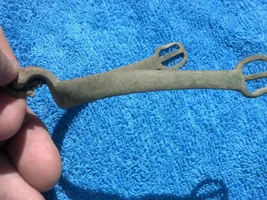
Did you find any carvings at the site that compared to anything on the LUE map?
 
1000041439.webp
 

Attachments

  • Screenshot_20250730_213618_Maps.webp
    Screenshot_20250730_213618_Maps.webp
    592.6 KB · Views: 57
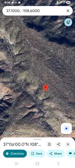
I asked ai to use that story and give coordinates without using lue map then use lue map and give coordinates that's what it gave me back. The first Pic is the one that came up with the lue map.
 
As a treasure map, the LUE map is probably obsolete, but as an historic Masonic artifact, it's an amazing record of Masonic lore. I'd love to see the original.

In post 63, I showed how the coordinates of the Kensington Runestone and the terrestrial coordinates of the star Capella can be found, by looking at information found in the upper right quadrant of the LUE map. I was looking for evidence that would show why the coordinates of Capella would be on the LUE map, when I found information that Capella could represent the cornucopia, the horn of plenty. Further investigation showed that two officers, in a Masonic Temple, the Senior Steward and the Junior Steward, have identical jewels of the cornucopia.

Senior Steward – Duties​

His Jewel is the Cornucopia, which is an exact duplicate of the Junior Steward’s Cornucopia. The Cornucopia signifies the “Horn of Plenty”. It is a goat horn filled with fresh fruits and vegetables to denote the “fruits of your labors” and represents a job well done. The Senior Steward sits to the right of the Junior Warden in the South.

The Senior Steward of a Masonic Lodge is an appointed officer of the Lodge.

The Senior Steward is tasked to understudy the Junior Deacon’s position and fill in for the Junior Deacon when absent.

The Junior Deacon’s principal role is to prepare the candidates during ritual and escort them to the lodge room and assist the Senior Deacon. In their entry Officer positions, both the Senior and Junior Stewards handle kitchen duties and wait staff for the members.
jewel-stewards.png

Junior Steward – Duties​

His Jewel is the Cornucopia, which is an exact duplicate to the Senior Steward’s Cornucopia. The Cornucopia signifies the “Horn of Plenty”. The Junior Steward sits to the left of the Junior Warden in the South.

It is a goat horn filled with the “fruits of your labors” and represents a job well done.

The Junior Steward of a Masonic Lodge is an appointed officer of the Lodge.

The Junior Steward is tasked to understudy the Senior Steward position and fill in for the Senior Steward in his absence. The Junior Steward’s principle role is to assist the Senior Steward and the Senior Deacon in the preparation of the Candidates.

Both the Senior and Junior Stewards carry rods, atop which are the jewels of their offices. The rods represent England’s Lord High Steward’s rod in the House of Lords.

Mdog here. Something else of interest is that both stewards sit on the south side of the Masonic Temple and the LUE map is oriented with south at the top, where the coordinates of the KRS and Capella are found. This picture shows how a British Masonic Temple is set up, notice that the Temple is oriented with south at the top. We know that south is at the top because the two seats occupied by the Senior and Junior Stewards are in the south of the Temple and those seats are shown at the top of the picture.

View attachment 2218662


View attachment 2218663
Great work. Great explanations. To make it easier in the future, all Lodges are "dark" in the north. Although you will see the Senior Deacon (hey that was me last year :) ) in the north, it is only because he has to be close to the Master so that he can receive messages from the Master and pass them to the Senior Warden. Otherwise....nobody sits in the north. The sun stays in the southern sky...
 
Great work. Great explanations. To make it easier in the future, all Lodges are "dark" in the north. Although you will see the Senior Deacon (hey that was me last year :) ) in the north, it is only because he has to be close to the Master so that he can receive messages from the Master and pass them to the Senior Warden. Otherwise....nobody sits in the north. The sun stays in the southern sky...
Thank you, Cuz.
 
Who drew?
And why?

We've seen examples of Travis Tumlinson's stonework.
The chimney being one of if not the earliest.
Was it a treasure map? A deceit? No the work was neither. But we have the advantage of his family declaring what it was.
Later Travis was carving again. And again icon type symbolism. Choices based on what???

Colonial era women's pockets. (Bear with me.)
Consider the utilitarian aspect aside and look at the samples of work.
Number of stiches per inch for example. How straight the stitches. Then to the art aspects. And subjects which certainly varied.
Now move closer towards us in time to the needlework samplers framed on house interior walls at time.
What they do is showcase skill and ability. A bit more structured in content. Alphabet letters maybe.

Sometimes the Lue map stalls me out into thinking someone was staring at the wall subconsciously and started a sampler of thier own.
Or worse , found a sampler of a pattern board of someone elses.
I don't try the Masons as the source though one or more could have been an influence.
( No reason a treasurer for example would need to elaborate.)

The original author / drawer would be nice to know. It's awful busy in content .
A map should get you somewhere without having to press your eyes against it as you progress.


View attachment 2217333

View attachment 2217332
I carved this on Peg Legs chimney next to the carvings made by Travis.
IMG_20171021_165023621_HDR.webp
 
I carved this on Peg Legs chimney next to the carvings made by Travis.View attachment 2219180

I don't know if I should laugh or jump up and down.
Danged tagger on the loose.
But they say confession is good for the soul. ( Post statute of limitations.)
 

Users who are viewing this thread

Back
Top Bottom