What's new

Oak Island Treasure Revelations

My question is, how would you locate it? Satellite imagery? Geophysical instrument? Dowsing?
Hi if I told you that I would render myself superfluous to requirements, and my mother didn't raise stupid children.

Oak Island Sage
Since i was making a genieric shaft in my diagram i only showed the platform that is needed to create the air lock.

This gets back to our earlier back and forth...
The horizontal flood tunnels had to use timbers, ceiling and wall support up to the point where it intersected the vertical shaft.

When the system is activated the flood tunnels would be well supported; however, as the sea water fills the vertical shaft to create the air lock the vertical walls are not protected exposing the clayish till to the seawater directly.

According to gravelteeth's geologist friend, this exposure would compromise, the shaft walls causing them to collapse.

It seems to me you need to show the airlock platform and wall support from the tunnels up to the airlock platform.
Let me make this clear to you, I have not found any evidence of cribbing used anywhere of Oak Island by the original miners, as you know they could have dug the shaft during the hot summertime. If you wish theorise that there was a lot cribbing used then please do so, if my own theories don't suit your investigation then I cant help you.
As for how they flooded the mine perhaps you could check out my post to GT 326. The next point to remember (as I explained in my book). during the time treasure was arriving for storage in the completed subterranean Repository the whole mine was completely dry. It was only when danger of exposure threatened all concerned with imminent arrest, and subsequent execution, that the mine was the flooded as it was designed to do in an emergency. At that stage 3 any collapsing of shafts or tunnels was the least of their worries now because they had already abandoned the treasure anyway. If you want to know reason why they never returned for their treasure at a safe future time, and why it remain today exactly as they left in abject panic, then read my book.

Oak Island Sage
 
I bet back in the day the islander's saw people digging out a ship that got stuck in the triangle swamp
Hi Brianbegreat, there was never a ship in the triangular shaped swamp, and it was actually a triangular shaped reservoir and it was man made. At the apex it overflowed as a filtered fresh water stream down to the north which was vitally required for the huge work force.
Oak Island Sage
 
If you want to know reason why they never returned for their treasure at a safe future time, and why it remain today exactly as they left in abject panic, then read my book.

Oak Island Sage

Sir you can not continue promoting your book without being a supporting vendor. If it continues your thread will be locked.
 
Hi Brianbegreat, there was never a ship in the triangular shaped swamp, and it was actually a triangular shaped reservoir and it was man made. At the apex it overflowed as a filtered fresh water stream down to the north which was vitally required for the huge work force.
Oak Island Sage
I just started the curse of oak Island episodes from season one is pretty cool
 
The key trick to it all of course is to employ a Cornish pick. (Obviously ; the pick found in a filled in hole explains that well enough.)
Use the pick to poke a hole (s) through the water to breath.
Swing it like a pendulum to accelerate time to reduce labor and supply requirements in order to reduce construction of a three year project into a mere couple of days.
Of course alternatively they could have just used a bellows operated air ventilation system similar those that were used in the film "The Great Escape".
Swinging a pick, no to much effort required that way, to flood the mine they just lit some fuses. check out post 326
Oak Island Sage
 
OIS,
It was post 236.

I get it now!
They were afraid of getting caught and losing the treasure so they dug west from the MP, under the swamp, 1500ft to South Shore and 300ft to 700ft under the Atlantic where they placed explosives.

Makes total sense they would choose South Shore over the east shore that's 500ft away.

I'm convinced.
 
Curse of oak island s6 ep15, Dye Harder, summarizes the dye test performed by the oak island treasure company. I believe their test showed dye came out at Smith's Cove and the east shore.

I haven't watched it since aired so i could be wrong.
 
Here's my confusion...
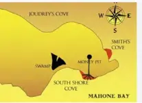
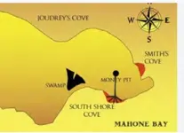
According to this pic, dye came out in two places; south and east. I believe it came from s2 e6 or s6 e15.

According to my understanding the finger drains shown to the south, were found in Smith's Cove. The east shore is Sheerdam Cove. If im correct, this picture was labeled wrong when identifying where the dye was seen by the Oak Island Treasure company.

If the above is correct then South Shore would then be located on the south shore of the western part of the island and 1500ft from the MoneyPit.
I derived this lacation from OIS schematic which shows box drains at Smith's Cove and four shafts off South Shore.

In order for OIS's schematic to be accurate, the box drains should have been drawn to the east shore and not to the south as shown in the pic.

Can someone explain the names correctly?
 

Attachments

  • Screenshot_20260210_060227_Chrome.webp
    Screenshot_20260210_060227_Chrome.webp
    37.2 KB · Views: 46
Last edited:
Here's my confusion...
According to this pic, dye came out in two places; south and east.

According to my understanding the finger drains shown to the south, were found in Smith's Cove. The east shore is Sheerdam Cove. If im correct this picture was labeled wrong when identifying where the dye was seen by the Oak Island Treasure company.

South shore is located would be the south shore of the western part of the island. I deived this from OIS schematic which shows box drains at Smith's Cove and four shafts off South Shore.

Can someone explain the names correctly?
BTW, i started down this rabbit hole because in OIS post #236, OIS stated the dye came out on South Shore proving the four vertical shafts creatng the ice holes.
But the diagram provided in previous post indicates these were box drains.

If finding the truth proves me wrong, im okay with that.
 
Here is my schematic drawing of the shaft and linked tunnels beneath Oak Island based on my own hypothesis as illustrated in my book.

Oak Island Sage
View attachment 2243439
OIS,
Could you provide a diagram of oak island and identify the location of the south shore and Smith's Cove.
I think that's the problem. Im just using the wrong locations.
 
OIS,
It was post 236.

I get it now!
They were afraid of getting caught and losing the treasure so they dug west from the MP, under the swamp, 1500ft to South Shore and 300ft to 700ft under the Atlantic where they placed explosives.

Makes total sense they would choose South Shore over the east shore that's 500ft away.

I'm convinced.
I am very please to hear that, I also think that the all shafts were dug first in Phase 1/ with different groups of miners simultaneously excavating at different locations across the island. The tunnels were added later and the distance between each shaft was measure on the surface with a long chord then played out in the corresponding and ascending tunnel below ground in order to ascertain the correct distance.
The triangular shaped pond was actually a man made reservoir that had a filter at the apex. It was designed as a fresh water stream that ran down to the north through swampy areas, and it served as a vital water supply for hundreds of workers, perhaps some wells were also added.
The tall bank of earth that runs along the bottom of the triangle is three hundred feet long and it was also artificially constructed. and for confirmation of that. the Smithsonian Experts declared that it was not a natural feature.
If you look at the CAD and just for a moment consider that it is accurate, we all then have to wonder what amount of treasure is still down in the undersea level repository, it has to be huge to justify all the cost, work, and planning that went into this covert top secret operation.
My research suggest we are talking by todays valuation of about a billion pounds worth of miscellaneous items of gold and silver items of treasure, and it was all abandoned in abject panic. Some items was stored ( like possibly Knights Templar treasure), and others were awaiting conversion into untraceable coinage or bars. That was the real purpose of the covert and ingeniously protected mine beneath Oak Island.

Oak Island Sage

 
OIS,
Could you provide a diagram of oak island and identify the location of the south shore and Smith's Cove.
I think that's the problem. Im just using the wrong locations.
There are lots of pictures of Oak Island on the net, some people have described it as looking like a little elephant with a curled up trunk, so his forehead would be Smiths Cove and his belly would the South Shore.:laughing7:

Oak Island Sage

 
BTW, i started down this rabbit hole because in OIS post #236, OIS stated the dye came out on South Shore proving the four vertical shafts creatng the ice holes.
But the diagram provided in previous post indicates these were box drains.

If finding the truth proves me wrong, im okay with that.
The box filter drains were only found a Smith Cove, the four inlets were off the south shore;
 
There are lots of pictures of Oak Island on the net, some people have described it as looking like a little elephant with a curled up trunk, so his forehead would be Smiths Cove and his belly would the South Shore.:laughing7:

Oak Island Sage

Any explanation as to why the finger drains at Smith's Cove are shown where you say South Shore is?
Because thats where i always thought Smith's Cove was.

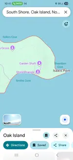
BTW, google maps puts Smith's Cove at the bottom, too.
 

Attachments

  • Screenshot_20260210_060227_Chrome.webp
    Screenshot_20260210_060227_Chrome.webp
    37.2 KB · Views: 44
Any explanation as to why the finger drains at Smith's Cove are shown where you say South Shore is?
Because thats where i always thought Smith's Cove was.

BTW, google maps puts Smith's Cove at the bottom, too.
Google maps
 

Attachments

  • Screenshot_20260210_104112_Maps.webp
    Screenshot_20260210_104112_Maps.webp
    73.2 KB · Views: 49
Here's why i wanted to get the distances correct...
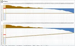
The attached diagram shows a side view of Oak Island. Elevation is 35ft. Its about 400ft to South Shore and 50ft deep at 300ft off South Shore where bubbles from the flood tunnels created ice holes.

A tunnel 2.5ftx4ftx 700ft has a volume of 7000 cubic feet. This is roughly the same volume of a 12ftx12ftx50ft vertcal shaft.
If the air lock is already in place when the tunnel is exploded to flood the tunnel, the airlock of 7000 cubic feet of air plus the air in the vertical shaft would keep the seawater from rushing in.

Now add the other 3 tunnels which would need to be blown in the correct sequence to fill each vertical shaft/airlock properly.
This could take a long time to equilibrate if it equilibrates at all.

Maybe the finger drains act as a vent.
 

Attachments

  • Airlock.webp
    Airlock.webp
    96 KB · Views: 48
Here's why i wanted to get the distances correct...
The attached diagram shows a side view of Oak Island. Elevation is 35ft. Its about 400ft to South Shore and 50ft deep at 300ft off South Shore where bubbles from the flood tunnels created ice holes.

A tunnel 2.5ftx4ftx 700ft has a volume of 7000 cubic feet. This is roughly the same volume of a 12ftx12ftx50ft vertcal shaft.
If the air lock is already in place when the tunnel is exploded to flood the tunnel, the airlock of 7000 cubic feet of air plus the air in the vertical shaft would keep the seawater from rushing in.

Now add the other 3 tunnels which would need to be blown in the correct sequence to fill each vertical shaft/airlock properly.
This could take a long time to equilibrate if it equilibrates at all.

Maybe the finger drains act as a vent.
 
BTW, google maps puts Smith's Cove at the bottom, too.

Yeah I've wondered about that for years. Google maps and some other mapping services show Smith's Cove in a different spot from where it has traditionally been referred to by searchers. I hesitate to say one or the other is "wrong", but the searcher tradition, and where the finger drains and u-shaped structure were found, is the east beach (you could even see the dam that CoOI crew built on the satellite view that year). "South shore" is, I believe, the south coast of the east drumlin.

--GT
 

Users who are viewing this thread

Back
Top Bottom